- Nagaland
-
Nagaland — State — 
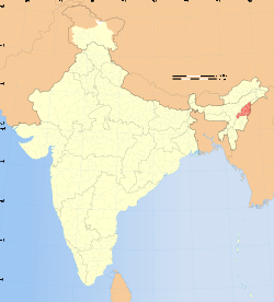
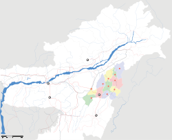
SealLocation of Nagaland in India Map of Nagaland Coordinates (Kohima): 25°40′N 94°07′E / 25.67°N 94.12°ECoordinates: 25°40′N 94°07′E / 25.67°N 94.12°E Country  India
IndiaEstablished December 1, 1963 Capital Kohima Largest city Dimapur Districts 11 Government – Governor Nikhil Kumar – Chief Minister Neiphiu Rio (Nagaland People's Front) – Legislature Unicameral (60 seats) – Parliamentary constituency 1 Area – Total 16,579 km2 (6,401.2 sq mi) Area rank 25th Population (2011) – Total 19,80,602 – Rank 24th – Density 119/km2 (308.2/sq mi) Time zone IST (UTC+05:30) ISO 3166 code IN-NL HDI  0.770 (medium)
HDI rank 4th (2005) Literacy 80.11% (13th) Official languages English Website nagaland.nic.in Nagaland is a state in the far north-eastern part of India. It borders the state of Assam to the west, Arunachal Pradesh and part of Assam to the north, Burma to the east and Manipur to the south. The state capital is Kohima, and the largest city is Dimapur. The state of Nagaland has an area of 16,579 km2 with a population of 19,80,602 (nineteen lakhs eighty thousand six hundred two) as per the 2011 census making it one of the smallest states of India. The state is mostly mountainous except those areas bordering Assam valley. Mount Saramati is the highest peak in Nagaland with a height of 3,840 metres and its range forms a natural barrier between Nagaland and Burma. It lies between the parallels of 98 degree and 96 degree East Longitude and 26.6 degree and 27.4 degree latitude North of the Equator.
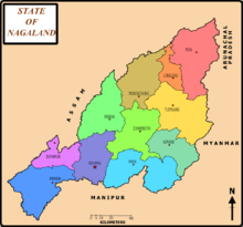
Nagaland, the 16th state of the Indian Union, was established on December 1, 1963. It is divided into eleven districts: Kohima, Phek, Mokokchung, Wokha, Zunheboto, Tuensang, Mon, Dimapur, Kiphire, Longleng and Peren. It is a largely mountainous state. Agriculture is the most important economic activity in Nagaland. Principal crops include rice, corn, millets, pulses, tobacco, oilseeds, sugarcane, potatoes and fibres. Other economy boosters are forestry, cottage industries, insurance, real estate and tourism.
Contents
History
The early history of the Nagas is the story of the customs and economic activities of the Naga tribes. The people were originally referred to as Naka in Burmese languages, which means 'people with pierced ears'.[1] It is also said that the word "Naga" was given by the British which actually means "Naked" (in Hindi "nanga" means naked). The British broadly classified the tribes of Manipur into "Nagas" and "Kukis". The Naga tribes had socio-economic and political links with tribes in Assam and Burma (Myanmar); even today a large population of Naga inhabits Assam. Following an invasion in 1816, the area, along with Assam, came under direct rule of Burma. This period was noted for oppressive rule and turmoil in Assam and Naga Hills. When the British East India Company took control of Assam in 1826, Britain steadily expanded its domain over modern Naga Hills. By 1892, all of the Naga Hills except the Tuensang area in the northeast was governed by the British. It was politically amalgamated into Assam. Missionaries played an important part in converting Nagaland's Naga tribes to Christianity.[2]
Not much is known about the history before the Burmese invasion or before the Naga people were converted to Christianity.
Road to statehood
During World War I, the British recruited several hundred Nagas and sent them to France to work as aides at the front. While in Europe, the Nagas, who had always been fractured by tribal differences, began to think that they should work towards becoming unified in order to protect their common interests. On their return to their homeland in 1918, they organized, and thus began the Naga nationalist movement.[3]
After the independence of India in 1947, the area remained a part of the province of Assam. Nationalist activities arose amongst a section of the Nagas, whose Naga National Council demanded a political union of their ancestral and native groups, damaged government and civil infrastructure and attacked government officials and civilians from other states of India. The Union government sent the Indian Army in 1955, to restore order. In 1957, the government began diplomatic talks with representatives of Naga tribes, and the Naga Hills district of Assam and the Tuensang frontier were united in a single political entity, Naga Hills Tuensang Area (NHTA),[4] that became a Union territory directly administered by the Central government with a large degree of autonomy. This was not satisfactory to the tribes, however, and soon agitation and violence increased across the state—included attacks on Army and government institutions, as well as civil disobedience and non-payment of taxes. In July 1960, following discussion between the Prime Minister of India and the leaders of the Naga People Convention (NPC), a 16-point Agreement was arrived at whereby the Government of India recognized the formation of Nagaland as a full-fledged State within the Union of India.[5] Accordingly, the territory was placed under the Nagaland Transitional Provisions Regulation, 1961[6] which provided for an Interim Body consisting of 45 members to be elected by various tribes according to the customs, traditions and usage of the respective tribes. Subsequently, Nagaland attained Statehood with the enactment of the State of Nagaland Act, 1962,[7] by the Parliament. The Interim Body was dissolved on November 30, 1963 and the State of Nagaland was formally inaugurated on December 1, 1963. After elections in January, 1964, the first Nagaland Legislative Assembly was constituted on February 11, 1964.[4]
Geography and climate
Nagaland is largely a mountainous state. The Naga Hills rise from the Brahmaputra Valley in Assam to about 2,000 feet (610 m) and rise further to the southeast, as high as 6,000 feet (1,800 m). Mount Saramati at an elevation of 12,552 feet (3,826 m) is the state's highest peak; this is where the Naga Hills merge with the Patkai Range in Burma. Rivers such as the Doyang and Diphu to the north, the Barak river in the southwest and the Chindwin river of Burma in the southeast, dissect the entire state.
Nagaland is rich in flora and fauna. About one-sixth of Nagaland is under the cover of tropical and sub-tropical evergreen forests—including palms, bamboo, and rattan as well as timber and mahogany forests. While some forest areas have been cleared for jhum cultivation, many scrub forests, high grass, reeds, and secondary dogs, pangolins, porcupines, elephants, leopards, bears, many species of monkeys, sambar, harts, oxen, and buffaloes thrive across the state's forests. The Great Indian Hornbill is one of the most famous birds found in the state. Blyth’s Tragopan, a vulnerable species of pheasant, is also found in the state and is the State Bird of Nagaland. It is sighted in mount Japfü and Dzükou valley of Kohima district, Satoi range in Zunheboto district and Pfütsero in Phek district. Of the mere 2500 tragopans sighted in the world, Dzükou valley is the natural habitat of more than 1,000.[8]
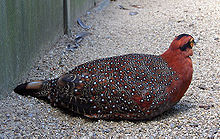 State Bird of Nagaland- Blyth's Tragopan
Nagaland has a largely monsoon climate with high humidity levels. Annual rainfall averages around 70–100 inches (1,800–2,500 mm), concentrated in the months of May to September. Temperatures range from 70 °F (21 °C) to 104 °F (40 °C). In winter, temperatures do not generally drop below 39 °F (4 °C), but frost is common at high elevations.
Culture and religion
The 14 tribes of Nagaland are Angami, Ao, Chakhesang, Chang, Khiamniungan, Konyak, Lotha, Phom, Pochury, Rengma, Sangtam, Sumi, Yimchungrü, and Zeliang, of which the Konyaks, Angamis, Aos, Lothas, and Sumis are the largest Naga tribes. Tribe and clan traditions and loyalties play an important part in the life of Nagas. Weaving is a traditional art handed down through generations in Nagaland. Each of the tribe has its own unique designs and colours, producing shawls, shoulder bags, decorative spears, table mats, wood carvings, and bamboo works. Naga Tribal dances of the Nagas give an insight into the inborn Naga reticence of the Naga people. War dances and other dances belonging to distinctive Naga tribes are a major art form in Nagaland. Some of these are Moatsu, Sekrenyi, Tuluni, Tokhu Emong,and Gan-ngai.
Christianity is the predominant religion of Nagaland. The state's population is 1.988 million, out of which 90.02% are Christians.[9] The census of 2001 recorded the state's Christian population at 1,790,349, making it, with Meghalaya and Mizoram, one of the three Christian-majority states in India and the only state where Christians form 90% of the population. The state has a very high church attendance rate in both urban and rural areas. Huge churches dominate the skylines of Kohima, Dimapur, and Mokokchung.
Nagaland is known as "the only predominantly Baptist state in the world."[10] Among Christians, Baptists are the predominant group, constituting more than 75% of the state's population, thus making it more Baptist (on a percentage basis) than Mississippi in the southern United States, where 52% of its population is Baptist.[citation needed]
Roman Catholics, Revivalists, and Pentecostals are the other Christian denomination numbers. Catholics are found in significant numbers in parts of Wokha district and Kohima district as also in the urban areas of Kohima and Dimapur.
Hinduism and Islam practiced by the non-Naga community are minority religions in the state, at 7.7% and 1.8% of the population respectively.
Languages
Each tribe of Nagaland have its own unique language. Nagas speak 60 different dialects belonging to the Sino-Tibetan family of languages. The traditional languages do not have any script of their own. The Christian missionaries used Roman script for these languages.
In 1967, the Nagaland Assembly proclaimed English as the official language of Nagaland and is the medium for education in Nagaland.
Nagamese, a creole language form of Indo-Aryan Assamese and local dialects is the most widely spoken market language. Every tribe has its own mother tongue but communicates with other tribes in Nagamese. As such Nagamese is not a mother tongue of any of the tribes; nor is it written.
Demography
The population of Nagaland is nearly two million people. The population mostly consists of Agriculturalist and around 75% of the population live in the rural areas. about one-third of this rural population can be considered to be below the poverty line. Most of them are more or less ignored due to the policy of the Central as well as the state government. Among the people living in urban areas one-fifth of them are below the poverty line.
Population change Census Pop. %± 1951 213,000 — 1961 369,000 73.2% 1971 516,000 39.8% 1981 775,000 50.2% 1991 1,210,000 56.1% 2001 1,990,000 64.5% 2011 1,980,602 -0.5% Source:Census of India[11] Administration
See also: List of districts of NagalandThe Governor is the constitutional head of state, representative of the President of India. He possesses largely ceremonial responsibilities apart from law and order responsibilities. The Legislative Assembly of Nagaland (Vidhan Sabha) is the real executive and legislative body of the state. The 60-member Vidhan Sabha — all elected members of legislature — forms the government executive and is led by the Chief minister. Unlike most states in India, Nagaland has been granted a great degree of state autonomy, as well as special powers and autonomy for Naga tribes to conduct their own affairs. Each tribe has a hierarchy of councils at the village, range, and tribal levels dealing with local disputes.
Districts – District Headquarters
- Dimapur District – Dimapur-Chumukedima
- Kiphire District – Kiphire
- Kohima District – Greater Kohima
- Longleng District – Longleng
- Mokokchung District – Mokokchung
- Mon District – Mon
- Peren District – Peren
- Phek District – Phek
- Tuensang District – Tuensang
- Wokha District – Greater Wokha
- Zunheboto District – Zunheboto
Urban centres
Greater cities and towns
Dimapur, Kohima, Mokokchung, Tuensang, Wokha, Mon, Zunheboto
Urban agglomerations
There are four urban agglomeration areas with population of more than 40,000 in the state:
Rank Metropolitan/Agglomeration Area District 2001 Census 1 Dimapur-Chumukedima Dimapur District 230,106 2 Greater Kohima Kohima District 99,795 3 Mokokchung Metropolitan Area Mokokchung District 60,161 4 Greater Wokha Wokha District 43,089 Greater (non-district headquarter) towns
Tuli town, Naganimora, Changtongya, Tizit, Tseminyu, Bhandari, Akuluto, Pfutsero
Economy
Macro-economic trend
This is a chart of trend of gross state domestic product of Nagaland at market prices estimated by Ministry of Statistics and Programme Implementation with figures in millions of Indian rupees.[12]
Year M 
1980 1,027 1985 2,730 1990 6,550 1995 18,140 2000 36,790 Nagaland's gross state domestic product for 2004 is estimated at $1.4 billion in current prices.
Agriculture is the most important economic activity in Nagaland, with more than 90% of the population employed in agriculture. Crops include rice, corn, millets, pulses, tobacco, oilseeds, sugarcane, potatoes, and threads. However, Nagaland still depends on the import of food supplies from other states. The widespread practice of jhum, tilling, has led to soil erosion and loss of fertility, particularly in the eastern districts. Only the Angami and Chakesang tribes in the Kohima and Phek districts use terracing techniques. And most of the Aos, Lothas, and Zeliangs in Mokokchung, Wokha, and Peren districts respectively till in the many valleys of the district. Forestry is also an important source of income. Cottage industries such as weaving, woodwork, and pottery are also an important source of revenue. Tourism is important, but largely limited due to insurgency since the last five decades.
Transportation
The railway network in the state is minimal. Broad gauge lines run 7.98 miles (12.84 km), National Highway roads 227.0 miles (365.3 km), and state roads 680.1 miles (1,094.5 km). There is one airport in Dimapur and another is being planned for Kohima, the state capital.
Railways
Railway: North East Frontier Railway
- Broad gauge: 7.98 miles (12.84 km)
- Total: 7.98 miles (12.84 km)
[Data Source: N. F. Railway, CME Office, Guwahati-781011]
Highways and towns served
National highways: 227.0 miles (365.3 km)
- NH 61: Kohima, Wokha, Tseminyu, Wokha, Mokokchung, Changtongya, Tuli
- NH 39: Dimapur-Kohima-Mao-Imphal (134.2 mi/216.0 km)
- NH 36: Dimapur-Doboka-Nagonan (105.6 mi/169.9 km)
- NH 150: Kohima-Jessami via Chakhabama-Pfutsero (74.6 mi/120.1 km)
- NH 155: Mokukchung-Jessami via Tuesang-Kiphire (206.9 mi/333.0 km)
State highways: 680.1 miles (1,094.5 km)
- Chakabama–Mokokchung Via Chazuba and Zunheboto
- Kohima–Meluri via Chakhabama
- Mokokchung–Mariani
- Mokokchung–Tuensang
- Namtola–Mon
- Tuensang–Mon–Naginimora
- Tuensang–Kiphire–Meluri
- Wokha–Merapani Road
[Source: Office of The Chief Engineer, P.W.D., Kohima, Nagaland]
Airways
Newspapers
- Nagaland Post
- Morung Express
- Nagaland Page
- Eastern Mirror
- [NE-INDIA,regional social network,http://www.ne-india.ning.com/]
See also
- Naga people
- Northeast Indian Railways during World War II
- Battle of the Tennis Court
- Edwin W. Clark
- Battle of Kohima
- Nagaland Baptist Church Council
- Angami Zapu Phizo
- Rani Gaidinliu
- Foreigners (Protected Areas) Order 1958 (India)
References
- ^ Inato Yekheto Shikhu (2007). A re-discovery and re-building of Naga cultural values. Daya Books. p. 4. ISBN 9788189233556.
- ^ Tezenlo Thong, “‘Thy Kingdom Come’: The Impact of Colonization and Proselytization on Religion among the Nagas,” Journal of Asian and African Studies, no. 45, 6: 595–609
- ^ The Naga Story – Then and Now
- ^ a b "Naga Hills Tuensang Area Act, 1957". http://www.indiankanoon.org/doc/727141/.
- ^ The 16-point Agreement arrived at between the Government of India and the Naga People’s Convention, July, 1960
- ^ Suresh K. Sharma (2006). Documents on North-East India: Nagaland. Mittal Publications. p. 225-228. ISBN 818324095X, 9788183240956.
- ^ The State Of Nagaland Act, 1962
- ^ [1]Nagaland struggles to save state bird- The Telegraph Calcutta Monday, July 5, 2010
- ^ Indian Census
- ^ Olson, C. Gordon. What in the World Is God Doing. Global Gospel Publishers: Cedar Knolls, NJ. 2003.
- ^ "Census Population" (PDF). Census of India. Ministry of Finance India. http://indiabudget.nic.in/es2006-07/chapt2007/tab97.pdf. Retrieved 2008-12-18.
- ^ Ministry of Statistics and Programme Implementation estimates
Further reading
- Stirn, Aglaja & Peter van Ham. The Hidden world of the Naga: Living Traditions in Northeast India. London: Prestel.
- Oppitz, Michael, Thomas Kaiser, Alban von Stockhausen & Marion Wettstein. 2008. Naga Identities: Changing Local Cultures in the Northeast of India. Gent: Snoeck Publishers.
- Kunz, Richard & Vibha Joshi. 2008. Naga – A Forgotten Mountain Region Rediscovered. Basel: Merian.
- Glancey, Jonathan. 2011. Nagaland: a Journey to India's Forgotten Frontier. London: Faber
- Hattaway, Paul. 2006. 'From Head Hunters To Church Planters'. Authentic Publishing
- Hutton, J. 1986. 'Report on Naga Hills' Delhi: Mittal Publication.
External links
- Official website
- Department of IT & Technical Education
- Department of Forest, Ecology, Environment and Wildlife
- Department of Horticulture
- Nagaland - Journey Through The Choir Of Clouds (Documentary)
- Nagaland travel guide from Wikitravel
- A photojournalist in Nagaland

Arunachal Pradesh 
Assam 
Sagaing Region,  Myanmar
 Nagaland

Manipur Districts of Nagaland States and territories of India States 
Union Territories Categories:- Nagaland
- Northeast India
- States and territories of India
- Seven Sister States
- States and territories established in 1963
Wikimedia Foundation. 2010.

