- Daman and Diu
-
Daman and Diu
दमन और दीव
દમણ અને દીવ
दमण आणि दीव
Damão e Diu— union territory — Coordinates 20°25′N 72°50′E / 20.42°N 72.83°ECoordinates: 20°25′N 72°50′E / 20.42°N 72.83°E Country India District(s) 2 Established 1987-05-30 Capital Daman Administrator Shri Satya Gopal, IAS Population
• Density
242,911 (6th(among u.t.))
• 2,169 /km2 (5,618 /sq mi)
HDI (2005) 
0.754 (medium)Official languages Marathi, Gujarati, Hindi, English Time zone IST (UTC+05:30) Area 112 km2 (43 sq mi) ISO 3166-2 IN-DD Daman and Diu (Hindi: दमन और दीव, Gujarati: દમણ અને દીવ, Marathi: दमण आणि दीव, Portuguese: Damão e Diu) is a union territory in India.
For over 450 years, the coastal enclaves of Daman and Diu on the Arabian Sea coast were part of Portuguese India, along with Goa and Dadra and Nagar Haveli. Goa, Daman, and Diu were incorporated into the Republic of India on 19 December 1961, by military conquest; Portugal did not recognize the Indian annexation of these territories until 1974. Goa, Daman, and Diu were administered as part of a single union territory until 1987, when Goa was granted statehood, leaving Daman and Diu as a separate union territory; each enclave constitutes one of the union territory's two districts.
Marathi, Gujarati and English are the official[1] and main languages.[2][3] The use of Portuguese goes on declining because it is no longer official nor taught at school, though a number of elderly people can still understand it, some even preferring it for discourse at home. In addition to standard Portuguese, there are two also shrinking Portuguese-based creole languages in Daman (known as Língua da Casa, "Home Language") and Diu (Língua dos Velhos, "Elders' Language"). English is increasingly accepted for official purposes.
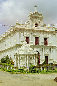
 St. Paul's Church in Diu
Contents
Districts
Population Growth Census Pop. %± 1951 49,000 — 1961 37,000 -24.5% 1971 63,000 70.3% 1981 79,000 25.4% 1991 102,000 29.1% 2001 158,000 54.9% Source:Census of India[4] - Diu District, an area of 40 km². The main settlement is the town of Diu.
- Daman District, an area of 28 sq mi or 72 km². The main settlement is the city of Daman.
Economy
Daman and Diu's gross state domestic product for 2005 is estimated at $156 million in current prices.
See also
Notes
- ^ The Goa, Daman and Diu Official Language Act, 1987
- ^ Tourism of India: Daman and Diu
- ^ Daman & Diu
- ^ "Census Population" (PDF). Census of India. Ministry of Finance India. http://indiabudget.nic.in/es2006-07/chapt2007/tab97.pdf. Retrieved 2008-12-18.
External links
- Daman Administration's Official Website
- Daman Online Website
- Daman and Diu Tourism's Official Website
- Daman and Diu at wikitravel
- Commissioner Linguistic Minorities; 42nd Report; July 2003 to June 2004


Arabian Sea 
Gujarat  Daman and Diu

Capital Districts Major towns Languages States and territories of India States 
Union Territories  State and Union Territory capitals of India
Agartala · Aizawl · Bangalore · Bhopal · Bhubaneswar · Chandigarh · Chennai (Madras) · Daman · Dehradun · New Delhi · Dispur · Gandhinagar · Gangtok · Hyderabad · Imphal · Itanagar · Jaipur · Jammu (in winter) · Kavaratti · Kohima · Kolkata (Calcutta) · Lucknow · Mumbai (Bombay) · Panaji (Panjim) · Patna · Puducherry (Pondicherry) · Port Blair · Raipur · Ranchi · Shillong · Shimla · Silvassa · Srinagar (in summer) · Thiruvananthapuram (Trivandrum)
Portuguese Empire North Africa15th century
1415–1640 Ceuta
1458–1550 Alcácer Ceguer (El Qsar es Seghir)
1471–1550 Arzila (Asilah)
1471–1662 Tangier
1485–1550 Mazagan (El Jadida)
1487– middle 16th century Ouadane
1488–1541 Safim (Safi)
1489 Graciosa16th century
1505–1769 Santa Cruz do Cabo
de Gué (Agadir)
1506–1525 Mogador (Essaouira)
1506–1525 Aguz (Souira Guedima)
1506–1769 Mazagan (El Jadida)
1513–1541 Azamor (Azemmour)
1515 São João da Mamora (Mehdya)
1577–1589 Arzila (Asilah)Sub-Saharan Africa15th century
1455–1633 Arguin
1470–1975 Portuguese São Tomé1
1474–1778 Annobón
1478–1778 Fernando Poo (Bioko)
1482–1637 Elmina (São Jorge
da Mina)
1482–1642 Portuguese Gold Coast
1496–1550 Madagascar (part)
1498–1540 Mascarene Islands16th century
1500–1630 Malindi
1500–1975 Portuguese Príncipe1
1501–1975 Portuguese E. Africa
(Mozambique)
1502–1659 St. Helena
1503–1698 Zanzibar
1505–1512 Quíloa (Kilwa)
1506–1511 Socotra
1557–1578 Portuguese Accra
1575–1975 Portuguese W. Africa
(Angola)
1588–1974 Cacheu2
1593–1698 Mombassa (Mombasa)17th century
1642–1975 Portuguese Cape Verde
1645–1888 Ziguinchor
1680–1961 São João Baptista de Ajudá
1687–1974 Portuguese Bissau2
18th century
1728–1729 Mombassa (Mombasa)
1753–1975 Portuguese São Tomé and Príncipe
19th century
1879–1974 Portuguese Guinea
1885–1975 Portuguese Congo1 Part of São Tomé and Príncipe from 1753. 2 Part of Portuguese Guinea from 1879. Southwest Asia16th century
1506–1615 Gamru (Bandar-Abbas)
1507–1643 Sohar
1515–1622 Hormuz (Ormus)
1515–1648 Quriyat
1515–? Qalhat
1515–1650 Muscat
1515?–? Barka
1515–1633? Julfar (Ras al-Khaimah)
1521–1602 Bahrain (Muharraq and Manama)
1521–1529? Qatif
1521?–1551? Tarut Island
1550–1551 Qatif
1588–1648 Matrah17th century
1620–? Khor Fakkan
1621?–? As Sib
1621–1622 Qeshm
1623–? Khasab
1623–? Libedia
1624–? Kalba
1624–? Madha
1624–1648 Dibba Al-Hisn
1624?–? Bandar-e KongIndian subcontinent15th century
1498–1545 Laccadive Islands
(Lakshadweep)16th century
Portuguese India
· 1500–1663 Cochim (Kochi)
· 1502–1661 Quilon (Coulão/Kollam)
· 1502–1663 Cannanore (Kannur)
· 1507–1657 Negapatam (Nagapatnam)
· 1510–1962 Goa
· 1512–1525 Calicut (Kozhikode)
· 1518–1619 Chaul
· 1523–1662 Mylapore
· 1528–1666 Chittagong
· 1531–1571 Chalium
· 1534–1601 Salsette Island
· 1534–1661 Bombay (Mumbai)
· 1535–1739 Baçaím (Vasai-Virar)
· 1536–1662 Cranganore (Kodungallur)
· 1540–1612 Surat
· 1548–1658 Tuticorin (Thoothukudi)16th century (continued)
Portuguese India (continued)
· 1559–1962 Daman and Diu
· 1568–1659 Mangalore
· 1579–1632 Hugli
· 1598–1610 Masulipatnam (Machilipatnam)
1518–1521 Maldives
1518–1658 Portuguese Ceylon (Sri Lanka)
1558–1573 Maldives
17th century
Portuguese India
· 1687–1749 Mylapore
18th century
Portuguese India
· 1779–1954 Dadra and Nagar HaveliEast Asia and Oceania16th century
1511–1641 Portuguese Malacca
1512–1621 Ternate
· 1576–1605 Ambon
· 1578–1650 Tidore
1512–1665 Makassar
1553–1999 Portuguese Macau
1571–1639 Decima (Dejima, Nagasaki)17th century
1642–1975 Portuguese Timor (East Timor)1
19th century
Portuguese Macau
· 1864–1999 Coloane
· 1849–1999 Portas do Cerco
· 1851–1999 Taipa
· 1890–1999 Ilha Verde
20th century
Portuguese Macau
· 1938–1941 Lapa and Montanha (Hengqin)1 1975 is the year of East Timor's Declaration of Independence and subsequent invasion by Indonesia. In 2002, East Timor's independence was recognized by Portugal & the world.
North America and the North Atlantic Ocean16th century
1500–1579? Terra Nova (Newfoundland)
1500–1579? Labrador
1516–1579? Nova ScotiaCentral and South America16th century
1500–1822 Brazil
1536–1620 Portuguese Barbados17th century
1680–1777 Nova Colônia do Sacramento
19th century
1808–1822 Cisplatina (Uruguay)Categories:- Daman and Diu
- States and territories of India
- Union Territories of India
- Diu
- Gulf of Khambhat
- Arabian Sea
Wikimedia Foundation. 2010.

