- Mombasa
-
"Mvita" redirects here. For the electoral constituency, see Mvita Constituency."Island of War" redirects here. For the television series, see Island at War.For the asteroid, see 1428 Mombasa.
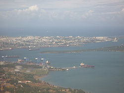
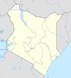
Mombasa — City — Aerial view of Mombasa from Port Reitz over Kilindini Harbour Location of Mombasa Coordinates: 4°03′S 39°40′E / 4.05°S 39.667°ECoordinates: 4°03′S 39°40′E / 4.05°S 39.667°E Country  Kenya
KenyaProvince Coast Province District Mombasa District Government – Mayor Ahmed Abubakar Mohdhar [1] Area – City 295 km2 (113.9 sq mi) – Land 230 km2 (88.8 sq mi) – Water 65 km2 (25.1 sq mi) Elevation 50 m (164 ft) Population (2009)[citation needed] – City 939,370 – Density 3,184/km2 (8,246.5/sq mi) – Urban 939,370 Time zone EAT (UTC+3) Mombasa is the second-largest city in Kenya. Lying next to the Indian Ocean, it has a major port and an international airport. The city also serves as the centre of the coastal tourism industry.
Also known as Mombas in colonial times, its name derives from Manbasa. This was the Arabic name of the former sultanate of Mvita, which had its capital here. In modern times the town is the headquarters of Mombasa District, which, like most other districts in Kenya, is named after its chief town.
Contents
Description
The city has a population of 939,370, as per the 2009 census,[citation needed] and is located on Mombasa Island, which is separated from the mainland by two creeks: Tudor Creek and Kilindini Harbour. The island is connected to the mainland to the north by the Nyali Bridge, to the south by the Likoni Ferry and to the west by the Makupa Causeway, alongside which runs the Kenya-Uganda Railway. The port serves both Kenya and countries of the interior, linking them to the Ocean. The city is served by Moi International Airport located in the northwest mainland suburb of Chaani, northwest of Changamwe area.
The city is mainly occupied by the Muslim Mijikenda/Swahili people. Over the centuries, there have been many immigrants and traders who settled in Mombasa, particularly from Iran, the Middle East, Somalia and the Indian sub-continent, who came mainly as traders and skilled craftsmen.
Traditional dress for the Swahili women is a brightly coloured, printed cotton sheet called a kanga, which may have inspirational slogans printed on it. Muslim women wear a covering known as a bui bui, that is traditionally black, along with a head covering called a hijaab, and sometimes wear a veil called a nikab. Men wear a type of sarong, which is coloured in bright bands, called a kikoi.
History
The founding of Mombasa is associated with two rulers: Mwana Mkisi (female) and Shehe Mvita. According to oral history and medieval commentaries, Shehe Mvita superseded the dynasty of Mwana Mkisi and established his own town on Mombasa Island. Shehe Mvita is remembered as a Muslim of great learning and so is connected more directly with the present ideals of Swahili culture that people identify with Mombasa. The ancient history associated with Shehe Mvita and the founding of an urban settlement on Mombasa Island is still linked to present-day peoples living in Mombasa. The Thenashara Taifa (or Twelve Nations) Swahili lineages recount this ancient history today and are the keepers of local Swahili traditions. Even though today Mombasa is a very heterogeneous cultural mix, families associated with the Twelve Nations are still considered the original inhabitants of the city.
Most of the early information on Mombasa comes from Portuguese chroniclers writing in the 16th century. The famous Moroccan scholar and traveller Ibn Battuta did visit Mombasa in 1331 on his travels on the eastern coast of Africa and made some mention of the city, although he only stayed one night. He noted that the people of Mombasa were Shãfi'i Muslims, "a religious people, trustworthy and righteous. Their mosques are made of wood, expertly built."
The exact founding date of the city is unknown, but it has a long history. Kenyan school history books place the founding of Mombasa as 900 A.D. It must have been already a prosperous trading town in the 12th century, as the Arab geographer Al Idrisi mentions it in 1151.
During the pre-modern period, Mombasa was an important centre for the trade in spices, gold, and ivory. Its trade links reached as far as India and China and oral historians today can still recall this period of local history. India history shows that there was trade links between Mombasa and Cholas of South India. Throughout the early modern period, Mombasa was a key node in the complex and far reaching Indian Ocean trading networks, its key exports then were ivory, millet, sesamum and coconuts.
In the late pre-colonial period (late 19th century), it was the metropolis of a plantation society, which became dependent on slave labour (sources contradict whether the city was ever an important place for exporting slaves) but ivory caravans remained a major source of economic prosperity. Mombasa became the major port city of pre-colonial Kenya in the Middle Ages and was used to trade with other African port cities, Persia, Arab traders, Yemen India and China.[2] 15th century Portuguese voyager Duarte Barbosa claimed, "[Mombasa] is a place of great traffic and has a good harbour in which there are always moored small craft of many kinds and also great ships, both of which are bound from Sofala and others which come from Cambay and Melinde and others which sail to the island of Zanzibar."[3]
Vasco da Gama was the first known European to visit Mombasa, receiving a chilly reception in 1498. Two years later, the town was sacked by the Portuguese. In 1502, the sultanate became independent from Kilwa Kisiwani and was renamed as Mvita (in Swahili) or Manbasa (Arabic). Portugal attacked the city again in 1528, and built Fort Jesus in 1593 in an attempt to colonise, from which time it was governed by a Captain-major. In 1638, it formally became a Portuguese colony (subordinated to Goa, as a stronghold on the route to Portuguese India).
In 1698, the town came under suzerainty of the Sultanate of Oman, but it became subordinate to Zanzibar, prompting regular local rebellions. Oman appointed three consecutive Governors (Wali in Arabic, Liwali in Swahili):
- 12 December 1698–December 1698: Imam Sa'if ibn Sultan
- December 1698–1728: Nasr ibn Abdallah al-Mazru'i
- 1728–12 March 1728: Shaykh Rumba
Next, Mombasa returned to Portuguese rule by captain-major Álvaro Caetano de Melo Castro (12 March 1728–21 September 1729), then four new Omani Liwali until 1746, when the last of them made it independent again (disputed by Oman), as the first of its recorded Sultans:
- 1746–1755: 'Ali ibn Uthman al-Mazru'i
- 1755–1773: Masud ibn Nasr al-Mazru'i
- 1773–1782: Abdallah ibn Muhammad al-Mazru'i
- 1782–1811: Ahmad ibn Muhammad al-Mazru'i (born 17–died 1814)
- 1812–1823: 'Abdallah ibn Ahmad al-Mazru'i (died 1823)
- 1823–1826: Sulayman ibn 'Ali al-Mazru'i
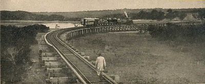
From 9 February 1824 to 25 July 1826, there was a British protectorate over Mombasa, represented by Governors. Omani rule was restored in 1826; seven liwalis where appointed. On 24 June 1837, it was nominally annexed by sultan of Zanzibar and Muscat Sayyid Said bin Sultan. On 25 May 1887, its administration was relinquished to the British East Africa Association (see Kenya). The sultan formally presented the town in 1898 to the British. It soon became the capital of the British East Africa Protectorate and is the sea terminal of the Uganda Railway, which was started in 1896. Many workers were brought in from British India to build the railway, and the city's fortunes revived. On 1 July 1895, it became part of Britain's Kenya protectorate (the coastal strip nominally under Zanzibari sovereignty).
Mombasa became the capital of the coastal Protectorate of Kenya in 1920. On December 12, 1963 it became part newly independent Kenya.[4]
On 28 November 2002, a suicide car bomb exploded at the Israeli-owned beachfront Paradise Hotel, killing three Israelis and ten Kenyans. About 20 minutes earlier, an unsuccessful attempt was made to shoot down an Arkia Israel Airlines Boeing 757 chartered tourist plane taking off from nearby Moi International Airport using surface-to-air missiles; nobody was hurt on the plane, which landed safely in Tel Aviv. The main suspect for both attacks is al Qaeda (see Kenyan hotel bombing).
In February 2010, Canadian, Amyn Mawani was made Mayor of the Day. He promised on his next visit he will help rebuild the fire dept. and improve the hospitals.
Geography and climate
Being a coastal town, Mombasa is characterised by a flat topography. The town of Mombasa is centered on Mombasa Island, but extends to the mainland. The island is separated from the mainland by two creeks, Port Reitz in the south and Tudor Creek in the north.
Mombasa has a warm, tropical climate. The amount of rainfall depends essentially on season. The rainiest months are April and May, while in January to February the rainfall is minimal.
Climate data for Mombasa Month Jan Feb Mar Apr May Jun Jul Aug Sep Oct Nov Dec Year Average high °C (°F) 32.0
(89.6)32.3
(90.1)32.6
(90.7)31.2
(88.2)29.3
(84.7)28.4
(83.1)27.7
(81.9)27.9
(82.2)28.8
(83.8)29.6
(85.3)30.6
(87.1)31.6
(88.9)30.17
(86.30)Average low °C (°F) 23.2
(73.8)23.6
(74.5)24.2
(75.6)23.9
(75.0)22.7
(72.9)21.3
(70.3)20.4
(68.7)20.3
(68.5)20.8
(69.4)22.0
(71.6)23.1
(73.6)23.3
(73.9)22.40
(72.32)Precipitation mm (inches) 33
(1.3)15
(0.59)56
(2.2)163
(6.42)240
(9.45)80
(3.15)70
(2.76)66
(2.6)72
(2.83)97
(3.82)92
(3.62)75
(2.95)1,059
(41.69)Source: WorldWeather.org[5] Economy
Mombasa is a major trade centre and home to Kenya's only large seaport, the Kilindini Harbour. Kilindini is an old Swahili term meaning "deep". The port is so called because the channel is naturally very deep. Kilindini Harbor is an example of a natural geographic phenomenon called a ria, formed millions of years ago when the sea level rose and engulfed a river that was flowing from the mainland.
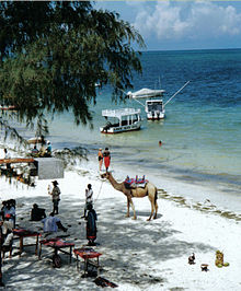
Mombasa is the centre of coastal tourism in Kenya. Mombasa Island itself is not a main attraction, although many people visit the Old Town and Fort Jesus. The Nyali, Kenyatta, Bamburi, and Shanzu beaches are located north of the city. The Shelly, Tiwi, and Diani beaches are located south of Mombasa. Several luxury hotels exist on these beaches, while the less expensive hotels are located further away.
Mombasa's northern shoreline is renowned for its vibrant 24-hour entertainment offers, including both family entertainment (water parks, cinemas, bowling, etc.), sports (watersports, mountain biking and gokarting), culinary offers (restaurants offering a wide range of specialties from Kenya, China, Japan, India, Italy, Germany and other countries) and night life(bars, pubs, clubs, discothèques, etc).
Other local industries include an oil refinery and the Bamburi Cement factory. The major intercontinental undersea telecom cables reach shore next to Mombasa, connecting East Africa to the rest of the world and supporting a fast-growing call centre business in the area.
Transport
Air
Moi International Airport serves the city of Mombasa. It is located in Port Reitz area, also known locally as Chaani area on the mainland metropolitan area. Flights to Nairobi and other Kenyan, European and Middle Eastern destinations depart from the airport. Besides Mombasa and Nairobi is well connected by chartered flights operated via Wilson airport.
Train
Mombasa has a railway station and Kenya Railways runs overnight passenger trains from Mombasa to Nairobi, though the service is less extensive than it used to be.
Road
Driving in Mombasa is straight-forward and the majority of the roads are tarmacked. Main roads include; Jomo Kenyatta Avenue, Digo Road, Nyerere Road, Nkurumah Road, Moi Avenue, Mama Ngina Drive, Barack Obama Road, Nairobi Highway and Nyali Road
Highways connect Mombasa to Nairobi, Dar es Salaam while northward road link to Malindi and Lamu, which also extends towards the border with Somalia.
Taxi
Taxis are common around the city and are a convenient form of transport although costly. Taxis may be found at the airport, outside most hotels, shopping malls and in the city.
Matatu
Within Mombasa, most local people use Matatus (mini-buses) which are extremely common in Kenya, to move around the city and its suburbs.
Tuk-Tuk
A Tuk-Tuk is an auto rickshaw, a motor vehicle with three wheels. It is widely used by people as a transport to move around the city and its suburbs.
Boda-boda
A boda-boda is originally a bicycle taxi. Especially in cities, the bicycles are more and more replaced by motorbikes.
Sea
Mombasa port is the largest in Kenya. There is little or no scheduled passenger service. International cruise ships frequent the port, thus giving Mombasa a "Natural Harbour".
Ferry
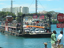
There is no bridge between Mombasa Island and south coast, instead the distance is served by ferries operated by the Kenya Ferry Service from Kilindini and Mtongwe to Likoni in the south coast of Mombasa. Operating ferries are aged. In 1994, a ferry serving Mtongwe route sank, leaving 270+ people perished.[1]
As a result of the major build-up of more luxurious hotels in South Coast and a lack of a direct bridge linking the South Coast to the North Coast, visiting tourists have the option of flying directly into the South Coast airstrip using the domestic airline, Air Kenya.[2]
Culture
Music & Nightlife
Taarab music, which originates from Zanzibar, has a prominent local presence. Recently, hip hop, reggae and bhangra have become popular, especially amongst the youth. Mombasa is mainly a tourism center is populated by hundreds of entertainment spots of all categories from night clubs, bars, hotels, fancy restaurants and many more. It has the most vibrant night life in Kenya catering for the mainly tourist population.
Sports
Currently Mombasa is represented in the Kenyan Premier League by Bandari F.C and Congo United F.C , which play at the Mombasa Municipal Stadium. Another team, Coast Stars, was relegated several years ago from the league. The only Mombasa-based team to win the league is Feisal F.C., the 1965 champions.Kiziwi leopards was the most popular team in the 1980s. There are several cricket teams in Mombasa. One of them is Mombasa Sports Club (MSC), whose ground was given ODI status in 2006. MSC has also a rugby union team playing in the Kenya Cup League, the premier rugby competition in Kenya. Mvita XI men and MSC ladies represent Mombasa in Kenyan field hockey leagues.
The 2007 World Cross Country Championships were held in Mombasa. Mombasa Marathon is competed annually in Mombasa. The town also hosts the biennial classic edition of Safari Rally and annually a Kenya National Rally Championship round.
Scuba Diving takes place mostly within the Mombasa marine park. The park has a length of about 8 km. Managed and maintained by Kenya Wild Life Service. There is an entry fee of US$ 15.- per day (September 2010).
Suburbs
Mombasa Island
Kizingo: Considered the prime residential area of Mombasa. The State House Mombasa,Provincial Headquarters, The Mombasa Law Courts, The Municipal Council are located in Kizingo. The Aga Khan Academy, Aga Khan High School, Serani Primary School, Serani High School, Santokben Nursery School, Coast Academy, Mombasa Primary School, Loreto Convent, Mama Ngina Girls' High School and the Government Training Institute (GTI) Mombasa are all part of Kizingo.
Kibokoni: Part of Old Town with Swahili architecture. Fort Jesus is in Baghani.
Kuze: Part of Old Town with Swahili culture and architecture. Originally flourishing with Swahili people but currently becoming a more cosmopolitan neighbourhood.
Makadara: Part of Old Town consisting of a high number of descendants of Baluchi former soldiers who settled within this area before it developed into a town. The name is derived from the Arabic word Qadr-ur-Rahman meaning fate of God.
Ganjoni: Primarily a middle class residential, home of second biggest dry dock of Africa after the one in South Africa.
Tudor: Another middle class residential area with homes and shops. The Mombasa Polytechnic University College (MPUC) is situated in this neighborhood
North Coast
Nyali: Also considered a prime and up-market residential area, it is on the mainland north of the island and is linked by the New Nyali Bridge. It has numerous beach front hotels in the area known as the "North Coast". Nyali has two distinct sections - the posh Old Nyali and the upcoming New Nyali. For many residents, Nyali has now become a self-contained residential area, with two Nakumatts, a multiplex cinema, shopping malls, banks, schools and post offices. This often eliminates the need for residents to cross the bridge and to go into the congested Mombasa city center. Nyali is home for the Nyali Cinemax complex, Mamba Village, the Nyali Golf Club, and some of the most prestigious academic institutions of the Coast Province.
Kongowea: Kongowea Location is a densely populated area with 15 villages, two sub-locations and an estimated population of 106,180 residents.[3] Kongowea is a cosmopolitan settlement mainly inhabited by people from mainland who migrated into the city in search of employment, mainly in service and manufacturing sector. The area is adjacent to the rich suburb of Nyali which employs a portion of the village residents. They are mainly hired as cheap labor as watchmen, gardeners, masons for up coming houses and house help. The most well known villages inside Kongowea include Kisumu Ndogo, Shauri Yako and Mnazi Mmoja, despite being located in this prime area, many residents live under extreme conditions – poor sanitation, high crime rate and lack of basic essential amenities like schools, hospitals and tap water. Kongowea is also home to one of the largest open-air markets in Eastern Africa.
Bamburi: also an outlying township (fifteen minutes drive) on the way to the town of Malindi. Bamburi is the location of Bamburi Portland Cement Company. Other notable features in the area are the Mijikenda public beach and Haller Park, a nature trail and wildlife conservatory.
Other areas include, Shanzu, Mkomani, Bombolulu, Kisauni, Mtwapa and kilifi.
The North Coast is famous for its broad entertainment industry which attracts locals and tourists as well.
South Coast
Likoni: is a lower income and lower middle class neighborhood connected to Mombasa Island by ferry. It is south of Mombasa Island and made up of mostly non-Swahili tribes. The ferry was the target of the Likoni Riots of 1997.[4]
Diani Beach: a beach resort area situated over the Likoni Ferry on the south coast of Mombasa. It is located some 36 km (22 mi) south of Mombasa city on the mainland coast and is a prime resort for many local and international tourists. Diani Beach has an airport at Ukunda town to cater for tourists who fly there directly from Nairobi Wilson or any other airports and airfields in the country.
Other
Magongo: is an outlying township 20 minutes driving distance northwest of Mombasa Island, situated on the Nairobi Highway. This fringe community lacks any effective electricity, water or sewer systems, with a general lack of infrastructure. Poverty, lack of sanitation, and unemployment continue to be the greatest issues for the Mikindani Township, which have ensured low health and safety standards for its residents. Poor, lower class housing is widespread, ranging from simple stone, two storey structures to mud and earth homes fitted with corrugated iron roofs. Much of the community works outside of the township, within Mombasa Island itself as there is a lack of employment and industry. There are number of small health clinics, shops, and a few public primary schools: Nazarene primary is one school, which is known in particular as being staffed by a revolving volunteer teacher base from Western, and predominately English speaking nations. This small town that serves as a link between the city and Moi International Airport. Magongo is also home to the Akamba Handicraft Cooperative.
Mikindani, a suburban area: This is an outlying township on the mainland along the Nairobi Highway.It is built in the heavy industrial sections of Changamwe and mainly accommodate the working class who either work in the industries, the town centre on the Island and the Port at Kilindini harbor.
Miritini:outlying township on the Mombasa Nairobi Highway which is first growing as a suburban area.
Changamwe: Industrial area which contains the Kipevu power generation projects, the Kenya Oil Refinery Company facility and housing estates such as Chaani and is the gateway to the Moi International Airport. The area has administrative offices of the D.O and the chiefs who serve the administrative division.
Port Reitz: Is a suburb on the mainland which contains a beach, oil refineries, housing estates etc. Moi International Airport and the Port Reitz District Hospital are in Port Reitz.
In Pop Culture
- Mombasa is noted in the 2010 film Inception as the place where a foot chase sequence occurs and where two members of the Inception team are recruited. The city of Tangier, Morocco serves as a stand-in for Mombasa.
- Finnish pop hit Mombasa by Taiska is about Mombasa.
- Mentioned in the Warren Zevon song Roland The Headless Thompson Gunner
- Mombasa expands into a mega city known as New Mombasa in the Halo Universe and is home to the massive Forerunner artifact that is buried beneath the city and extends into the Indian Ocean. It is also the main setting for Halo 3: ODST.
Twin cities
- Mombasa is a sister city of:[5][6]
City State Country Year Seattle  Washington
 United States
April 9, 2010 Long Beach  California
 United States
April 9, 2010 Honolulu  Hawaii
 United States
April 9, 2010 See also
References
- ^ Francis Thoya, "The restless ghosts of Mtongwe", Wednesday magazine, November 19, 2003.
- ^ Flying into South Coast, Mombasa
- ^ [2] 2009 Kenya National Bureau of Statistics
- ^ http://www.hrw.org/reports/2002/kenya/Kenya0502-06.htm
- ^ Online Directory: Kenya, Africa, Sister Cities International
- ^ Kenya, Africa, Sister Cities International
External links
Portuguese Empire North Africa15th century
1415–1640 Ceuta
1458–1550 Alcácer Ceguer (El Qsar es Seghir)
1471–1550 Arzila (Asilah)
1471–1662 Tangier
1485–1550 Mazagan (El Jadida)
1487– middle 16th century Ouadane
1488–1541 Safim (Safi)
1489 Graciosa16th century
1505–1769 Santa Cruz do Cabo
de Gué (Agadir)
1506–1525 Mogador (Essaouira)
1506–1525 Aguz (Souira Guedima)
1506–1769 Mazagan (El Jadida)
1513–1541 Azamor (Azemmour)
1515 São João da Mamora (Mehdya)
1577–1589 Arzila (Asilah)Sub-Saharan Africa15th century
1455–1633 Arguin
1470–1975 Portuguese São Tomé1
1474–1778 Annobón
1478–1778 Fernando Poo (Bioko)
1482–1637 Elmina (São Jorge
da Mina)
1482–1642 Portuguese Gold Coast
1496–1550 Madagascar (part)
1498–1540 Mascarene Islands16th century
1500–1630 Malindi
1500–1975 Portuguese Príncipe1
1501–1975 Portuguese E. Africa
(Mozambique)
1502–1659 St. Helena
1503–1698 Zanzibar
1505–1512 Quíloa (Kilwa)
1506–1511 Socotra
1557–1578 Portuguese Accra
1575–1975 Portuguese W. Africa
(Angola)
1588–1974 Cacheu2
1593–1698 Mombassa (Mombasa)17th century
1642–1975 Portuguese Cape Verde
1645–1888 Ziguinchor
1680–1961 São João Baptista de Ajudá
1687–1974 Portuguese Bissau2
18th century
1728–1729 Mombassa (Mombasa)
1753–1975 Portuguese São Tomé and Príncipe
19th century
1879–1974 Portuguese Guinea
1885–1975 Portuguese Congo1 Part of São Tomé and Príncipe from 1753. 2 Part of Portuguese Guinea from 1879. Southwest Asia16th century
1506–1615 Gamru (Bandar-Abbas)
1507–1643 Sohar
1515–1622 Hormuz (Ormus)
1515–1648 Quriyat
1515–? Qalhat
1515–1650 Muscat
1515?–? Barka
1515–1633? Julfar (Ras al-Khaimah)
1521–1602 Bahrain (Muharraq and Manama)
1521–1529? Qatif
1521?–1551? Tarut Island
1550–1551 Qatif
1588–1648 Matrah17th century
1620–? Khor Fakkan
1621?–? As Sib
1621–1622 Qeshm
1623–? Khasab
1623–? Libedia
1624–? Kalba
1624–? Madha
1624–1648 Dibba Al-Hisn
1624?–? Bandar-e KongIndian subcontinent15th century
1498–1545 Laccadive Islands
(Lakshadweep)16th century
Portuguese India
· 1500–1663 Cochim (Kochi)
· 1502–1661 Quilon (Coulão/Kollam)
· 1502–1663 Cannanore (Kannur)
· 1507–1657 Negapatam (Nagapatnam)
· 1510–1962 Goa
· 1512–1525 Calicut (Kozhikode)
· 1518–1619 Chaul
· 1523–1662 Mylapore
· 1528–1666 Chittagong
· 1531–1571 Chalium
· 1534–1601 Salsette Island
· 1534–1661 Bombay (Mumbai)
· 1535–1739 Baçaím (Vasai-Virar)
· 1536–1662 Cranganore (Kodungallur)
· 1540–1612 Surat
· 1548–1658 Tuticorin (Thoothukudi)16th century (continued)
Portuguese India (continued)
· 1559–1962 Daman and Diu
· 1568–1659 Mangalore
· 1579–1632 Hugli
· 1598–1610 Masulipatnam (Machilipatnam)
1518–1521 Maldives
1518–1658 Portuguese Ceylon (Sri Lanka)
1558–1573 Maldives
17th century
Portuguese India
· 1687–1749 Mylapore
18th century
Portuguese India
· 1779–1954 Dadra and Nagar HaveliEast Asia and Oceania16th century
1511–1641 Portuguese Malacca
1512–1621 Ternate
· 1576–1605 Ambon
· 1578–1650 Tidore
1512–1665 Makassar
1553–1999 Portuguese Macau
1571–1639 Decima (Dejima, Nagasaki)17th century
1642–1975 Portuguese Timor (East Timor)1
19th century
Portuguese Macau
· 1864–1999 Coloane
· 1849–1999 Portas do Cerco
· 1851–1999 Taipa
· 1890–1999 Ilha Verde
20th century
Portuguese Macau
· 1938–1941 Lapa and Montanha (Hengqin)1 1975 is the year of East Timor's Declaration of Independence and subsequent invasion by Indonesia. In 2002, East Timor's independence was recognized by Portugal & the world.
North America and the North Atlantic Ocean16th century
1500–1579? Terra Nova (Newfoundland)
1500–1579? Labrador
1516–1579? Nova ScotiaCentral and South America16th century
1500–1822 Brazil
1536–1620 Portuguese Barbados17th century
1680–1777 Nova Colônia do Sacramento
19th century
1808–1822 Cisplatina (Uruguay)Categories:- Mombasa
- Populated coastal places in Kenya
- Populated places in Coast Province
- Provincial capitals in Kenya
- Former British colonies
- Former Portuguese colonies
- Mombasa District
- Port cities in Africa
- Ports and harbours of the Indian Ocean
- Swahili city-states
Wikimedia Foundation. 2010.

