- Mbeere District
-
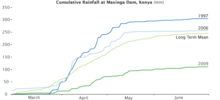 Cumulative rainfall at Masinga dam, Kenya.
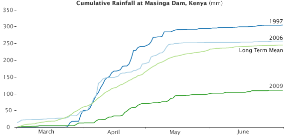
Mbeere District is an administrative district in the Eastern Province of Kenya. Its capital town is Siakago. The district has a population of 170,950 and an area of 2,093 km².[1] The district was split from Embu District in 1996. The natives here speak kimbeere language. The district hosts the famous seven folks dams, which include: Masinga dam, Kamburu dam, Gitaru dam, Kindaruma dam and Kiambere dam. The dams are a part of Tana River. Other local places of interest include the Mwea National Reserve, and Kiangombe mountain, which peaked at 1804 metres stands out compared to adjacent topography, although is not as spectacular as the Mount Kenya located less than 100 kilometres northwest.
The dorminant crops found there include fruits like Mangoes, melons, pawpaws and passion fruits. the farmers in this area grow maize, beans, cowpeas, pigeon peas, black peas-njavi, others like millet are seasonally grown there.
Mbeere district has also come to be known with Miraa, 2nd largest producer after Meru. The miraa crop is commonly grown in the Northern part of the district.
Mbeere district has only one local authority, Mbeere county council. The district has two constituencies: Siakago Constituency and Gachoka Constituency. Currently the district is divided into four administrative divisions: More changes are however expected with the split of the districts in year 2009; Mbeere South district whose headquarters is in Kiritiri town and Mbeere North district with headquarters in Siakago town.
Administrative divisions Division Population* Urban pop.* Headquarters Gachoka 59,102 - Evurore 36,841 0- Mwea 40,680 - Siakago 34,330 2,312 Siakago Total 170,953 -- - * 1999 census. Sources: [1], [2], References
External links
- http://www.reliefweb.int/library/documents/2006/govt-ken-mbeere-31aug.pdf
- http://www.aridland.go.ke/districts.asp?DistrictID=14
Categories:
Wikimedia Foundation. 2010.