- Eastern Province (Kenya)
-
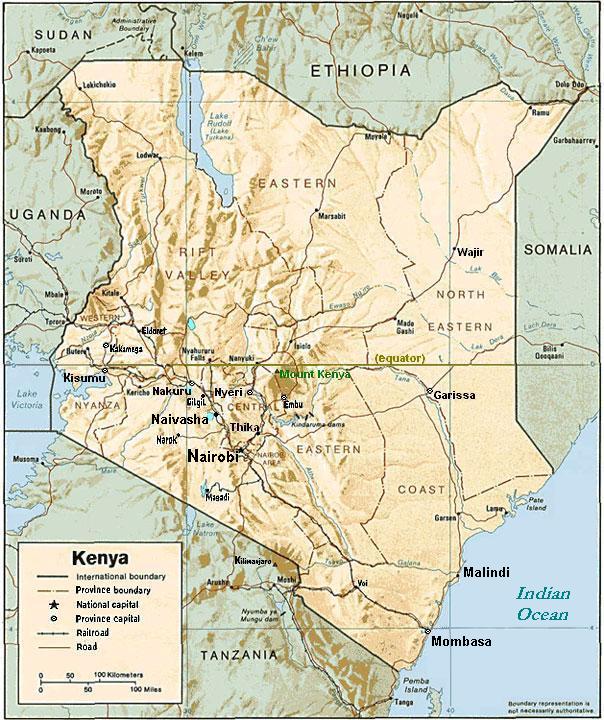
Eastern Province — Province — Location in Kenya.
Coordinates: 0°0′N 38°0′E / 0°N 38°ECoordinates: 0°0′N 38°0′E / 0°N 38°E Country  Kenya
KenyaNo. of districts: 26 Capital Embu Area - Total 159,891 km2 (61,734.3 sq mi) Population (1999) - Total 4,631,779 Time zone EAT (UTC+3) 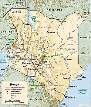
The Eastern Province of Kenya is one of seven regions of the country. Its northern boundary is with Ethiopia; the North Eastern Province and Coast Province lie to the east and south; and the remainder of Kenya's provinces, including Central Province, run along its western border. The provincial capital is Embu. On 16 July 2009, the province was sub-divided in to 3 Sub-Provinces namely lower eastern with Machakos as headquarters, central eastern with Meru as headquarters, and upper eastern with Marsabit as headquarters; however it still remains to be seen how these changes will take effect due to the political instability in the current coalition government. The sub-division of provinces were carried out in all seven Provinces of Kenya, excluding Nairobi.
The province is principally inhabited by the Meru and Kamba and several pastoralist communities. In 1979 its population was 2.7 million; in 1999, 4,631,779 (according to the 1999 census). In terms of area, it is the second largest province (159,891 km²).
Contents
Geography
Eastern Province of Kenya includes the Chalbi Desert, Mount Kenya, and the eastern half of Lake Turkana. The climate is arid to semi-arid. Its most important permanent river is Ewaso Ng'iro.
Districts
- District (capital)
- Embu (Embu)
- Isiolo (Isiolo)
- Kitui (Kitui)
- Machakos (Machakos)
- Makueni (Wote)
- Marsabit (Marsabit)
- Mbeere (Siakago)
- Meru Central (Meru)
- Meru North a (Maua)
- Meru South b (Chuka)
- Moyale (Moyale)
- Mwingi (Mwingi)
- Tharaka (Tharaka)
a Also known as Nyambene District.
b Also known as Nithi District.Districts after 2007
Several new district were created in 2007 in Kenya, also in Eastern Province [1]:
District Capital Chalbi Maikona Embu Embu Garbatula Garba Tula Igembe Maua Imenti North Meru Imenti South Nkubu Isiolo Isiolo Kangundo Kangundo Kibwezi Makueni Kitui Kitui Kyuso Kyuso Laisamis Korr Machakos Machakos Makueni Wote Marsabit Marsabit Mbeere Siakago Mbooni Meru Central Gatimbi Meru South (Nithi) Chuka Moyale Moyale Mutomo (Kitui South) Mutomo Mwala Mwingi Mwingi Tharaka Marimanti Tigania Urru Yatta Kithimani References
References
Categories:

Wikimedia Foundation. 2010.