- Mauá
-
Mauá 
Flag
Coat of armsLocation of Mauá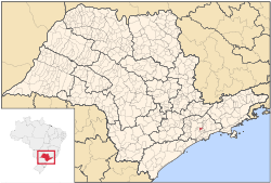
Coordinates: 23°40′04″S 46°27′39″W / 23.66778°S 46.46083°W Country  Brazil
Region Southeast State  São Paulo
Government - Mayor Oswaldo Dias (PT) Area - Total 62.293 km2 (24.1 sq mi) Elevation 818 m (2,684 ft) Population (2010)[1] - Total 417,281 - Density 6,463.69/km2 (16,740.9/sq mi) Time zone UTC-3 (UTC-3) - Summer (DST) UTC-2 (UTC-2) Postal Code 09300-000 Area code(s) +55 11 Website Mauá, São Paulo Coordinates: 23°40′04″S 46°27′39″W / 23.66778°S 46.46083°W
Mauá (IPA: [ma'wa]) is a municipality in the state of São Paulo, in Brazil. Is part of the metropolitan region of São Paulo. The population as of 2006 is 413,943 inhabitants (11º largest city in population of the state), the density is 6,645.4/km² and the area is 62.6 km². The density is even greater, since one third of the city is industrial area and 10% is rural or forest. This place name comes from the Tupi language and means, the one that is high. As it's a municipality, it can be translated to high city.
Mauá has the 23rd largest GDP of São Paulo state.
Is the birthplace of brazilian mother tableware industry.
Contents
Economy
Although there are various types of economic activity in the city (Logistics, Metallurgy, Chemical and Electrical Materials, and Petrochemical), Maua is still remembered as the "Capital of China and Pottery", because this activity has been very important for the development of the municipality. There are two industrial centers (Capuava and Sertãozinho) and a large petrochemical complex located where is the refinery of Petrobras, the RECAP. These poles transformed Mauá into one of the largest industrial parks in the country. Major road interventions are being implemented (the Beltway and the prolongation of the Avenue Jacu-Pêssego/Nova Trabalhadores), which, due to easier access to the city should influence the growth of industrial activity which today suffers from the bottleneck of the road network and its chronic lack of maintenance.
Some companies with headquarters or branches in the municipality of Mauá: ALCAN (Aluminum), CGE[disambiguation needed
 ] (metallurgical), Petrobras (petroleum refining, cooking gas and nitrogen), Philips (Lamps division), LED, Liquigas (cooking gas), Chevron-Oronite (petroleum products), Oxiteno-Ultrapar (gas oil products, except CNG), Firestone (tires), Saint-Gobain (automotive glass), Magneti Marelli-Cofap (metallurgy and automotive parts).
Transport
It's served by the trains of line 10 of the CPTM, passing through the Capuava, Mauá and Guapituba stations. It's also served by the METRA bus rapid transit, having one stop and a trolleybus line that leaves the Terminal Sônia Maria.
Currently, the city bus system is operated by the companies Viação Cidade de Mauá and Grupo Leblon.
Geography
Climate
The city is located 818 meters above sea level, at the boundary between the Serra do Mar and the plateau. As a result, the city's climate is considered subtropical, with average temperature during the year at around 18°C, rarely exceeding 30°C in summer. In winter the average is 14°C.
Topography
The landscape of Mauá is dominated by the formation of steep hills and peaks, typical of the Serra do Mar and by deep valleys and wetlands, today mostly grounded and occupied in a disordered way, which explains the high incidence of flooding. Only the valley of Tamanduateí River on Capuava district is typically flat. Historical account describe the place as where the first bandeirantes, coming from São Vicente, saw the Planalto Paulista (São Paulo plateau) region and gave the name of Borda do Campo (that means Boundary of the Countryside) to the region, for making the transition between the Serra do Mar and the Planalto Paulista. The highest point in town is the Morro Pelado (Naked Hill), with 867 meters (the third highest of the Greater São Paulo), but the city is, on average, the highest of metropolitan region, due to the lack of flat areas.
Hydrography
The city has a special characteristic hydrographic: not be crossed by any water course from another city, since, due to the high altitude, all streams that cross the territory of Mauá born in the city.
In the city born the Tamanduateí River, the third largest affluent of the Tietê River in Greater Sao Paulo, the Oratório river and the Pinheirinho and Guaió rivers. The most important waterways in the urban area are the Taboão Stream, the Corumbé Stream and the Stream Capitão João (under which is the XXII November square, the downtown). Due to the disordered occupation of the floodplains, many places that before worked as absorbers of excess rain water were grounded and the city has several points at high risk of flooding. The situation was eased with the construction of four reservoirs between the years 1998 and 2002. However, due to lack of maintenance, excessive garbage and siltation, the reservoirs can not effectively contain the total flood risk. Besides the disordered occupation, lack of sewerage and waste treatment makes the urban waterways completely polluted.
Vegetation
The city, due to great variation in altitude has a broad spectrum of natural landscapes, although much has been transformed by human occupation. The hillsides were originally occupied by a lush Atlantic Forest, though already mixed with species of Araucaria and Planalto Paulista typical of altitude climate. In the city, the Atlantic Forest areas most preserved are the wellsprings, the tank of Paulista, the Ecological Park Santa Luzia and the slopes of Guaraciaba. The wetlands were largely covered by reeds and cattails, plants typical of wetlands and marshlands. Currently, only the Taboão stream have the original vegetation in the urban environment, but will lose much of it due to rectification works to link up with the new Beltway. The valleys of the rivers Guaió and Pinheirinho and the region of Cappburgo are still with this vegetation, despite growing local slum. The peaks of the hills, especially the higher were covered by grasses and thin vegetation, currently the chief representative is the Morro Pelado, which takes its name from the very low vegetation cover.
References

Ferraz de Vasconcelos, São Paulo and Suzano Santo André 
Ferraz de Vasconcelos, Ribeirão Pires and Suzano  Mauá
Mauá 

Ribeirão Pires BrazilHistory First inhabitants · Colonization · Empire · Old Republic · Vargas Era · Second Republic · Military rule · ContemporaryGeography Regions · States · Mesoregions · Microregions · Municipalities · Islands · Coastline · Climate · Environment · Extreme points · Protected areas · CapitalsGovernment Constitution · Federal government · President · National Congress · Foreign relations · Law · Law enforcement · MilitaryPolitics Economy Society Demographics · People · Languages · Religion · Immigration · Education · Health · Crime · Social issues · Largest cities · ApartheidCulture  Category ·
  Portal ·
  WikiProject
Demographics of Brazil Economic and social Apartheid · Attractions · Law · Crime · Education · GDP · Health · Human Development · Human Rights (LGBT Rights) · Immigration · Languages · People · Politics · Poverty · Races · Religions · Traditions · Wealth
Ethnic groups BrazilAfricaAmericasNorth AmericaCaribbeanHaitianSouth AmericaAsiaBy EthnicityBy Country
or RegionEasternSouthernEast IndianWesternEuropeBy EthnicityBy Country
or RegionNorthernWesternCentralSouthernBalkanEastern50 largest cities of Brazil by population Categories:- Populated places in São Paulo (state)


Wikimedia Foundation. 2010.