- Ourinhos
-
Ourinhos 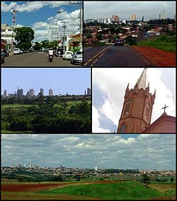

Flag
SealLocation in Brazil
 Ourinhos
Coordinates: 22°58′28″S 49°52′19″W / 22.97444°S 49.87194°WCoordinates: 22°58′28″S 49°52′19″W / 22.97444°S 49.87194°W Country Brazil State São Paulo Government - Mayor Toshio Misato (PSDB) Area - Total 296.89 km2 (114.6 sq mi) Elevation 483 m (1,585 ft) Population (2010) - Total 103,026 - Density 347.82/km2 (900.8/sq mi) Time zone UTC-3 (UTC-3) - Summer (DST) UTC-2 (UTC-2) Website Ourinhos Official Site
Ourinhos is a municipality/county in the state of São Paulo in Brazil. The population in 2010 is 103,026 and the area is 296.203 km2 (114.365 sq mi). The elevation is 483 metres (1,585 ft).The city of Ourinhos was emancipated from Salto Grande in the 1910s. One version of its etymology is that the name "Ourinhos" (small gold pebbles) is a reference to the old city of Ourinho, on the other side of the Paranapanema river, which today is Jacarezinho, in Paraná state. Today, the city is formed by the town of Ourinhos, which is the only district headquarters, also subdivided into about 120 neighborhoods. It is also one of the main cities in Sao Paulo state's SW region, having trade and services as its main economic activities. In agriculture, sugar cane, soy, and corn (maize) are the main crops.
The city also has an important cultural tradition that goes from arts and crafts to theater, music and sports. The city also stands out in its promotion of cultural and economic events and fairs often organized by the city hall and with the help of local companies. The major one is the Ourinhos Agricultural and Industrial Fair (FAPI), which is held annually in June and is considered one of the largest events of this nature in Brazil.
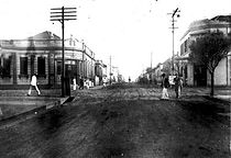 Paraná street in 1936
 Categories:
- Populated places in São Paulo (state)
- São Paulo (state) geography stubs


Wikimedia Foundation. 2010.