- Rio de Janeiro
Infobox Settlement
name = Rio de Janeiro
settlement_type = Municipality
official_name = The Municipality ofSão Sebastião do Rio de Janeiro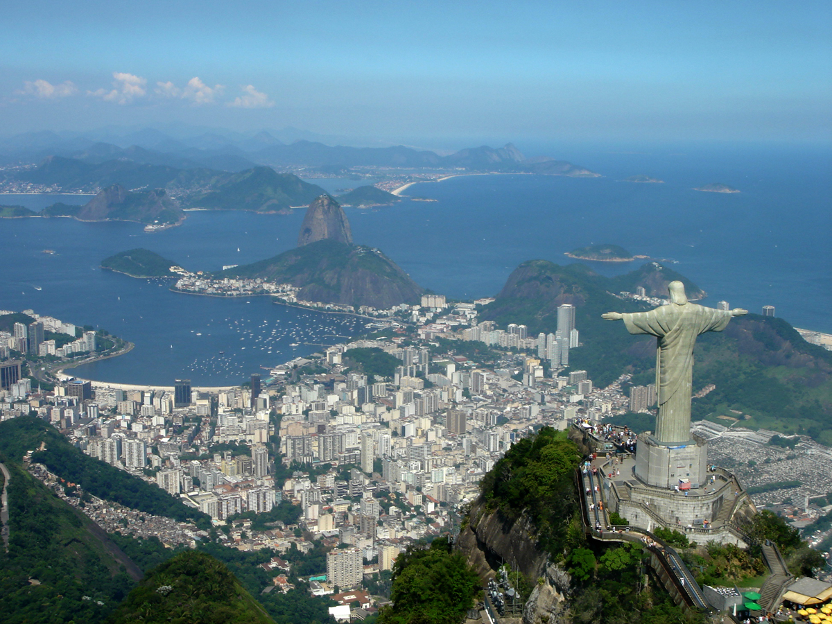
imagesize = 250px
image_caption = View of Rio de Janeiro
nickname = "Cidade Maravilhosa" ("The Marvelous City") or simply, Rio
image_

mapsize = 250px
map_caption = Location in the State of Rio de Janeiro
latd = 22 |latm = 54 |lats = 30 |latNS = S
longd = 43 |longm = 11 |longs = 47 |longEW = W
subdivision_type = Country
subdivision_type1 = Region
subdivision_type2 = State
subdivision_name = flag|Brazil
subdivision_name1 = Southeast
subdivision_name2 =
leader_title = Mayor
leader_name =César Maia (Democrats)
established_title = Founded
established_date =March 1 ,1565
area_magnitude = 1 E8
area_total_sq_mi = 486.5
area_total_mi2 = 1,182
population_as_of = 2007
population_total = 7,050,472 (2nd)
population_density_km2 = 4781
population_metro = 13,100,000
timezone = BST
utc_offset = -3
timezone_DST = BDT
utc_offset_DST = -2
blank_name = HDI (2000)
blank_info = 0.842 – high
website = [http://www.rio.rj.gov.br/ City of Rio de Janeiro]Rio de Janeiro ("River of January", pronounced|ˈhiw dʒi ʒʌˈnejɾu in
Brazilian Portuguese , IPA|/ˈriːoʊ di ʒəˈnɛroʊ/ in English), is the second largest city ofBrazil , behindSão Paulo . The city is capital of the state of Rio de Janeiro. It was the capital of Brazil for almost two centuries, from 1763 to 1822 while it was a Portuguese colony and from 1822 to 1960 as an independent nation. It was the capital of thePortuguese Empire from 1808 to 1821. Commonly known as just Rio, the city is also nicknamed "A Cidade Maravilhosa", or "The Marvelous City".It is famous for its natural settings, its
Carnival celebrations,samba and other music, and hotel-lined tourist beaches, such as Copacabana andIpanema , paved with decorated black and cream swirl pattern mosaics known locally as "pedra portuguesa". Some of the most famous local landmarks in addition to the beaches include the giant statue ofJesus , known as Christ the Redeemer ('Cristo Redentor') atopCorcovado mountain, which has recently been named one of theNew Seven Wonders of the World ; Sugarloaf mountain ("Pão de Açúcar") with its cable car; the "Sambódromo ", a giant permanent parade stand used during Carnival; and Maracanã stadium, one of the world's largest football stadiums.Rio also boasts the two
world 's largestforest s inside anurban area . The first is the forest in "Parque Estadual da Pedra Branca", or "White Stone State Park". The second, almost connected to the first, is the famous "Floresta da Tijuca", or "Tijuca Forest ". [ [http://www.almacarioca.com.br/tijuca.htm Floresta da Tijua] pt icon]The
Galeão - Antônio Carlos Jobim International Airport connects Rio de Janeiro with many Brazilian cities and also operates several international flights. The city is home to the Federal University of Rio de Janeiro.Despite its charm and beauty, Rio is reputed to be one of the most violent cities in the world.Folha de S. Paulo website, [http://www1.folha.uol.com.br/folha/cotidiano/ult95u368007.shtml "Número de homicídios cai no Brasil"] , published
30 January 2008 , retrieved14 February 2008 . See the.xls file linked in the article.] [ [http://news.bbc.co.uk/2/hi/americas/6214299.stm BBC NEWS | Americas | Rio hit by deadly gang violence ] ] [ [http://www.foxnews.com/story/0,2933,241262,00.html FOXNews.com - Brazil to Send Federal Troops to Rio de Janeiro to Quell Gang Violence - International News | News of the World | Middle East News | Europe News ] ] [ [http://news.bbc.co.uk/2/hi/americas/6214299.stm BBC NEWS | Americas | Rio hit by deadly gang violence ] ] [ [http://www.foxnews.com/story/0,2933,241262,00.html FOXNews.com - Brazil to Send Federal Troops to Rio de Janeiro to Quell Gang Violence - International News | News of the World | Middle East News | Europe News ] ]Geography
climate chart
Rio de Janeiro
23|29|114
23|28|105
23|28|103
22|27|137
21|26|86
19|25|80
18|24|56
17|23|50
18|24|87
20|25|88
21|27|96
22|28|169
source= [http://weather.uk.msn.com/monthly_averages.aspx?wealocations=wc:BRXX3272 MSN Weather]
float=right
clear=noneRio de Janeiro is located at 22 degrees, 54 minutes south
latitude , 43 degrees 14 minutes westlongitude . The population of the City of Rio de Janeiro is about 6,136,652, [cite web|url=http://www.ibge.gov.br/home/estatistica/populacao/estimativa2005/estimativa.shtm?c=1|title=Estimativas para 1° de Julho de 2006|language=Portuguese|publisher=IBGE |accessdate=2007-07-18] occupying an area of convert|1182.3|km2|sqmi|1. [cite web|url=http://www.ibge.gov.br/home/geociencias/cartografia/default_territ_area.shtm?c=5|title=Área Territorial Oficial|language=Portuguese|publisher=IBGE|accessdate=2007-07-18]The population of the larger
metropolitan area is estimated at 11-12 million. It was Brazil's capital until 1960, whenBrasília took its place. Residents of the city are known asCarioca s. The city's current mayor (2006) isCesar Maia . The official song of Rio is "Cidade Maravilhosa" (translated as "Marvelous City").Climate
Rio has a
tropical climate. [ [http://www.weather.com/activities/travel/businesstraveler/nutshell/rio_dg.html Rio de Janeiro Destination Guide] fromThe Weather Channel . Retrieved2007 -12-02 .] The temperature occasionally reaches over 40°C (104°F) in inland areas of the city, and extreme maximum temperatures above 30°C (86°F) can happen every month. In the main tourist areas (south side, where the beaches are located), the temperature is moderated by the cool sea-breezes from the ocean.The average annual minimum temperature is 20°C (68°F), the average annual maximum temperature is 26°C (79°F) and the average annual temperature is 23°C (73.5°F). The average yearly precipitation is 1,086 mm. The minimum temperature ever registered was 4.8°C (40°F) in July 1928, but temperatures below 10°C (50°F) are rare in most of city today, the absolute maximum reached 43.2°C (110°F) in January 1984. [ [http://www.bbc.co.uk/weather/world/city_guides/results.shtml?tt=TT001730 Average Conditions, Rio de Janeiro, Brazil] .
BBC Weather Center. Retrieved2007 -12-03 .]Cityscape
History
Guanabara Bay was reached by Portuguese explorers in an expedition led by Portuguese explorerGaspar de Lemos onJanuary 20 ,1502 ; hence Rio de Janeiro, "January River." There is a legend that the mariners named the place thus because they thought the mouth of the bay was actually the mouth of a river, but no experienced sailor would make that mistake. At the time, river was the general word for any large body of water.An unofficial European presence in the area began not long after. In 1519 when
Ferdinand Magellan resupplied his ships in the bay, French smugglers were already using the bay as a post for smugglingbrazilwood . When French naval officerNicolas Durand de Villegaignon arrived in 1555 with a fleet of two ships and 600 soldiers and colonists, he founded the first permanent European settlement in the area. The colony was referred to as "France Antarctique ". The colonists consisted of mainly FrenchHuguenot s and Swiss Calvinists. Villegaignon left in 1557 after disputes with some of the colonists.The city was founded on
March 1 1565 , by Portugueseknight Estácio de Sá , who called it "São Sebastião do Rio de Janeiro" (St Sebastian of the January River), [cite encyclopedia | title = Rio de Janeiro | encyclopedia = Britannica | url = http://www.britannica.com/EBchecked/topic/504192/Rio-de-Janeiro#tab=active~checked%2Citems~checked&title=Rio%20de%20Janeiro%20--%20Britannica%20Online%20Encyclopedia | accessdate = 2008-08-07 ] in honour ofSaint Sebastian (day of death traditionally on January 20). For centuries, the settlement was commonly called São Sebastião – or even 'Saint Sebastian' – instead of the currently popular second half of its name. The city was founded as a base from which to invade the French settlement. They succeeded in 1567 and the French were expelled. Later, "São Sebastião" was frequently attacked by pirates andprivateer s, especially by then enemies of Portugal, such as theNetherlands andFrance .The exact place of Rio's foundation is at the foot of Pão-de-Açúcar (Sugarloaf Mountain). Later, the whole city was moved within a palisade on top of a hill, imitating the medieval European defense strategy of fortified
castle s – the place has since then been called "Morro do Castelo" (Castle Hill). Thus, the city developed from the current center (Downtown, see below) southwards and then westwards (with large parts built over reclaimed land); an urban movement which continues today.In the late 16th century, the Portuguese crown began treating the village as a strategic location for the
Atlantic transit of ships between Brazil, the African colonies and Europe. Fortresses were built and an alliance was formed with nearby native tribes to defend the settlement. Invaders – Rio's neighbor,Niterói , for instance, was founded by Araribóia, a Tamoio Indian chief, for defensive purposes.Sugar cane was the first industry in the area. First native, and later African, slaves were used for manual labor. Eventually the industry dwindled as higher quality sugar cane from northern Brazil became more available.Until early in the 18th century, the city was threatened or invaded by several, mostly French
pirate s andbuccaneer s, such asJean-François Duclerc andRené Duguay-Trouin . Fact|date=October 2008 After 1720, when the Portuguese foundgold anddiamond s in the neighboring captaincy ofMinas Gerais , Rio de Janeiro became a much more useful port for exporting wealth thanSalvador, Bahia , which is much farther to the north. In 1763, the colonial administration in Portuguese America was moved to Rio. The city remained primarily a colonial capital until 1808, when the Portuguese royal family and most of the associatedLisbon nobles, fleeing fromNapoleon 's invasion of Portugal, moved to Rio de Janeiro. The kingdom's capital was transferred to the city, which, thus, became the only European capital outside of Europe. As there was no physical space or urban structure to accommodate hundreds of noblemen who arrived suddenly, many inhabitants were simply evicted from their homes.When Prince Pedro I proclaimed the independence of Brazil in 1822, he decided to keep Rio de Janeiro as the capital of his new empire. Rio continued as the capital of Brazil after 1889, when the
monarchy was replaced by arepublic .Until the early years of the 20th century, the city was largely limited to the neighborhood now known as the historic Downtown business district (see below), on the mouth of Guanabara Bay. The city's center of gravity began to shift south and west to the so-called Zona Sul (South Zone) in the early part of the 20th century, when the first tunnel was built under the mountains located betweenBotafogo and the neighborhood now known as Copacabana. That beach's natural beauty, combined with the fame of theCopacabana Palace Hotel, "the" luxury hotel of the Americas in the 1930s, helped Rio to gain the reputation it still holds today as a beach party town (though, this reputation has been somewhat tarnished in recent years byfavela violence resulting from thenarcotics trade). Plans for moving the nation's capital city to the territorial centre had been occasionally discussed, and whenJuscelino Kubitschek was elected president in 1955, it was partially on the strength of promises to build a new capital. Though many thought that it was just campaignrhetoric , Kubitschek managed to haveBrasília built, at great cost, by 1960. OnApril 21 that year the capital of Brazil was officially moved from Rio de Janeiro to Brasília.Between 1960 and 1975 Rio was a capital city under the name State of Guanabara (after the bay it borders). However, for administrative and political reasons, a presidential decree known as "The Fusion" removed the city's federative status and merged it with the state of Rio de Janeiro in 1975. Even today, some "Cariocas" advocate the return of municipal autonomy.
City districts
The city is commonly divided into the historic downtown (Centro); the tourist-friendly South Zone (Zona Sul), with its world-famous beaches; the residential North Zone (Zona Norte); and the West Zone (Zona Oeste), with the newer
Barra da Tijuca district.Downtown
(coord|22.905392|S|43.177128|W|scale:15000_region:BR|name=Downtown) Centro (Downtown in American English or CBD in other English use) is the historic centre of the city, as well as its financial centre. Sites of interest include the
Paço Imperial , built during colonial times to serve as a residence for the Portuguese governors of Brazil; many historic churches, such as theCandelária Church , the colonial Cathedral and the modern-styleRio de Janeiro Cathedral . Around the Cinelândia square there are several landmarks of the "Belle Époque " of Rio, such as the Municipal Theatre and theNational Library building. Among its several museums, theMuseu Nacional de Belas Artes (National Museum of Fine Arts) and the Museu Histórico Nacional (National Historical Museum) are the most important. Other important historical attractions in central Rio include its Passeio Público, an 18th-century public garden, as well as the imposing arches of the "Arcos da Lapa ", a Roman-styleaqueduct built around 1750. A "bondinho" (tram ) leaves from a city center station, crosses the aqueduct (converted to a tram viaduct in 1896) and rambles through the hilly streets of the Santa Teresa neighbourhood nearby.Downtown remains the heart of the city's business community. Some of the largest companies in Brazil have their head offices here, including
Petrobras andVale (formerly Companhia Vale do Rio Doce), the two largest Brazilian corporations.outh Zone
(coord|22.974199|S|43.199444|W|scale:75000_region:BR|name=South Zone)The South Zone of Rio de Janeiro (in Portuguese: "Zona Sul") is composed of several districts, amongst which are
São Conrado ,Leblon ,Ipanema ,Arpoador , Copacabana and Leme, which compose Rio's famous Atlantic beach coastline. Other districts in the South Zone are Glória,Flamengo ,Botafogo andUrca , which borderGuanabara Bay andSanta Teresa ,Cosme Velho ,Laranjeiras , Humaitá, Lagoa,Jardim Botânico andGávea . It is the richest region of the city and the most famous overseas.The neighbourhood of Copacabana beach hosts one of the world's most spectacular
New Year's Eve parties ("Reveillon"), as more than two million revelers crowd onto the sands to watch thefireworks display. As of 2001, the fireworks have been launched from boats, to improve the safety of the event. To the north of Leme, and at the entrance to Guanabara Bay, is the district ofUrca and the Sugarloaf Mountain ('Pão de Açúcar'), whose name describes the famous mountain rising out of the sea. The summit can be reached via a two-stage cable car trip from Praia Vermelha, with the intermediate stop on Morro da Urca. It offers views second only to Corcovado mountain.One of the highest hills in the city is the 842 metres (2,762 ft) high
Pedra da Gávea (Crow's nest Rock) near thebotanical gardens . On the top of its summit is a huge rock formation (some, such asErich von Däniken in his 1973 book, "In Search of Ancient Gods", claim it to be a sculpture) resembling a sphinx-like, bearded head that is visible for many kilometers around.Hang gliding is a popular activity on the nearby Pedra Bonita (Beautiful Rock). After a short flight, gliders land on the Praia do Pepino (Cucumber Beach) in São Conrado.Since 1961, theTijuca Forest ("Floresta da Tijuca"), the largest city-surrounded urban forest and the second largest urban forest in the world, has been aNational Park . The largest urban forest in the world is the Floresta da Pedra Branca (White Rock Forest), which is also located in the city of Rio de Janeiro. [cite web|url=http://www.biodiversityreporting.org/index.php?pageId=sub&lang=pt_BR¤tItem=article&docId=18381&c=Brasil&cRef=Brazil&year=2006&date=abril%202005 |title=Poluição afeta Pedra Branca|publisher=O Globo |accessdate=2007-07-18|year=2005|month=April|language=Portuguese|first=Daniel Ernesto|last=Engelbrecht Ferreira] The Catholic University of Rio (Pontifícia Universidade Católica do Rio de Janeiro or PUC-Rio) is located at the edge of the forest, in the Gávea district. The 1984 film "Blame it on Rio " was filmed nearby, with the rental house used by the story's characters sitting at the edge of the forest on a mountain overlooking the famous beaches.North Zone
The North Zone of Rio (in portuguese: "Zona Norte") is home to the Maracanã stadium, once the world's highest capacity
football (soccer) venue, able to hold nearly 199,000 people, as it did the World Cup final of 1950. In modern times its capacity has been reduced to conform with modern safety regulations and the stadium has introduced seating for all fans. Currently undergoing renovation, it has now the capacity for 95,000 fans; it will eventually hold around 120,000 people. Maracanã was site for the Opening and Closing Ceremonies and football competition of the 2007Pan-American Games .Besides the Maracanã, the North Zone of Rio also holds other tourist and historical attractions, such as 'Manguinhos', the home of
Instituto Oswaldo Cruz , a centenarian biomedical research institution with a main building fashioned like aMoorish palace, and the beautifulQuinta da Boa Vista , the park where the historical old Imperial Palace is located. Nowadays, the palace hosts the National Museum, specializing in Natural History, Archaeology and Ethnology.The International Airport of Rio de Janeiro (Galeão – Antônio Carlos Jobim International Airport, named after the famous Brazilian musician "'Tom" Jobim), the main campus of the
Federal University of Rio de Janeiro at the Fundão Island, and the State University of Rio de Janeiro, in Maracanã, are also located in the Northern part of Rio.This region is also home to most of the Samba Schools of Rio de Janeiro such as Mangueira, Salgueiro, Império Serrano, Unidos da Tijuca, among others. Some of the main neighbourhoods of Rio's North Zone are
Tijuca , which shares the Tijuca Rainforest with the South Zone; Grajaú, Vila Isabel, Méier, São Cristovão Madureira and Penha among others.West Zone
The West Zone (in portuguese: "Zona Oeste") is the region furthest from the centre of Rio de Janeiro. It includes
Barra da Tijuca ,Jacarepaguá ,Recreio dos Bandeirantes , Vargem Grande, Vargem Pequena,Realengo , Padre Miguel, Bangu, Campo Grande, Jardim Sulacap, Paciência and Santa Cruz. Neighbouring districts within the West Zone reveal stark differences between social classes. The area has industrial zones, but some agricultural areas still remain in its wide area.Westwards from the older zones is Barra da Tijuca, a flat expanse of formerly undeveloped coastal land, which is currently experiencing a wave of new construction. It remains an area of accelerated growth, attracting some of the richer sectors of the population as well as luxury companies. High rise flats and sprawling
shopping centre s give the area a far more American feel than the crowded city centre. The urban planning of the area, made in the late 1960s, resembles that of United Statessuburb s, though mixing zones of single-family houses with residential skyscrapers. The beaches of Barra da Tijuca are also popular with the city's residents. Barra da Tijuca is the home of Pan-American Village for the 2007Pan American Games .Beyond the neighbourhoods of Barra da Tijuca and Jacarepaguá, another district that has exhibited economic growth is Campo Grande. Some sports competitions in the
Pan-American Games of 2007 were held in the Miécimo da Silva Sports Centre, nicknamed the 'Algodão' (Cotton) Gymnasium, and others in the Ítalo del Cima Stadium, in Campo Grande.Demographics
According to the
IBGE of 2007, there were 11,714,000 people residing in the Metropolitan Region of Rio de Janeiro. The population density was 4.781 inh./km². The last PNAD (National Research for Sample of Domiciles) census revealed the following percentage: 6,278,704 White people (53.6%), 3,935,904Pardo (Brown) [See alsoMultiracial ] people (33.6%), 1,440,822 Black people (12.3%) and 58,000 Asian or Amerindian people (0.5%). [cite book|url=ftp://ftp.ibge.gov.br/Indicadores_Sociais/Sintese_de_Indicadores_Sociais_2007/Tabelas|title=Síntese de Indicadores Sociais 2007|publisher= IBGE |location=Rio de Janeiro, Brazil|format=PDF|isbn=85-240-3919-1|accessdate=2007-07-18|year=2007|language=Portuguese]Different
ethnic group s contributed to the formation of the population of Rio de Janeiro. Before European colonization, there were at least seven different indigenous peoples speaking 20 languages in the region. A part of them joined the Portuguese and the other the French. Those who joined the French were then exterminated by the Portuguese, while the other part was assimilated. [ [http://paginas.terra.com.br/educacao/Ludimila/indiosrj.htm Tem índio no Rio ] ]Rio de Janeiro is home to the largest Portuguese population outside of
Lisbon . The Portuguese community (the oldest in the city) has left a remarkable legacy to Rio de Janeiro since the 16th century. After independence, Rio de Janeiro remained gateway for thousands of Portuguese immigrants, mainly in the first decades of the 20th century. They were mainly poor peasants who, later, found prosperity in Rio as small traders. [ [http://www1.ibge.gov.br/brasil500/portugueses.html Brasil 500 anos ] ] Besides the influence onethnicity , the Portuguese left their architecture and also theaccent of the inhabitants of Rio de Janeiro, which sounds more Portuguese than the other Brazilians.The black community, whose ancestors were brought as slaves, had a great impact in the composition of Rio's population. Nowadays, nearly half of its population is Black or part-Black. Most of the slaves in Rio came from
Angola orMozambique . Rio's carnival, with itssamba , is probably the most remarkable influence from the black community. [ [http://www1.ibge.gov.br/brasil500/negros/origem.html Brasil 500 anos ] ]As a result of the diversity of immigrants who came to Brazil between the end of the 19th and early 20th centuries, one may find in Rio de Janeiro many Jews, Arabs of Lebanese and Syrian origin, Italians, Spaniards, Germans and people from different parts of Brazil.
Population growth
;Changing demographics of the city of Rio de JaneiroColors= id:lightgrey value:gray(0.9) id:darkgrey value:gray(0.7) id:sfondo value:rgb(1,1,1) id:barra value:rgb(0.6,0.7,0.8)
ImageSize = width:640 height:300PlotArea = left:50 bottom:50 top:30 right:30DateFormat = x.yPeriod = from:0 till:7000000TimeAxis = orientation:verticalAlignBars = justifyScaleMajor = gridcolor:darkgrey increment:1500000 start:0ScaleMinor = gridcolor:lightgrey increment:50000 start:0BackgroundColors = canvas:sfondo
BarData= bar:1872 text:1872 bar:1890 text:1890 bar:1900 text:1900 bar:1920 text:1920 bar:1940 text:1940 bar:1950 text:1950 bar:1960 text:1960 bar:1970 text:1970 bar:1980 text:1980 bar:1991 text:1991 bar:2000 text:2000 bar:2007 text:2007
PlotData= color:barra width:20 align:left
bar:1872 from:0 till: 274972 bar:1890 from:0 till: 522651 bar:1900 from:0 till: 811443 bar:1920 from:0 till: 1157873 bar:1940 from:0 till: 1764141 bar:1950 from:0 till: 2377451 bar:1960 from:0 till: 3281908 bar:1970 from:0 till: 4251918 bar:1980 from:0 till: 5090700 bar:1991 from:0 till: 5336179 bar:2000 from:0 till: 5851914 bar:2007 from:0 till: 6093472
PlotData=
bar:1872 at: 274972 fontsize:S text: 274.972 shift:(-8,5) bar:1890 at: 522651 fontsize:S text: 522.651 shift:(-10,5) bar:1900 at: 811443 fontsize:S text: 811.443 shift:(-10,5) bar:1920 at: 1157873 fontsize:S text: 1.157.873 shift:(-10,5) bar:1940 at: 1764141 fontsize:S text: 1.764.141 shift:(-10,5) bar:1950 at: 2377451 fontsize:S text: 2.377.451 shift:(-10,5) bar:1960 at: 3281908 fontsize:S text: 3.281.908 shift:(-10,5) bar:1970 at: 4251918 fontsize:S text: 4.251.918 shift:(-10,5) bar:1980 at: 5090700 fontsize:S text: 5.090.700 shift:(-10,5) bar:1991 at: 5336179 fontsize:S text: 5.336.179 shift:(-10,5) bar:2000 at: 5851914 fontsize:S text: 5.851.914 shift:(-10,5) bar:2007 at: 6093472 fontsize:S text: 7.050.472 shift:(-10,5)
TextData= fontsize:S pos:(20,20) text:
"Source: Planet Barsa Ltda. [ [http://brasil.planetasaber.com/default.asp Barsa Planeta Ltda] ] "
Religion
ister cities
Rio de Janeiro's sister cities are:
References
ee also
*
List of mayors of Rio de Janeiro
*Niteroi
* State of Rio de JaneiroExternal links
sisterlinks|Rio de Janeiro
Official
* [http://www.rio.rj.gov.br Official homepage] (some pages available in en)
* [http://transito.rio.rj.gov.br/ Rio De Janeiro Webcams]
* [http://www.rio.rj.gov.br/riotur/en/ Riotur]
* [http://www.ibge.gov.br/english/ Brazilian Institute of Geography and Statistics (IBGE)]Education
* [http://www.cgmax.com.br CGMAX] - Computer Graphics University at Rio de Janeiro
* [http://www.uva.br UVA-Rio] - Veiga de Almeida University of Rio de Janeiro
* [http://www.puc-rio.br PUC-Rio] - the Pontifical Catholic University of Rio de Janeiro
* [http://www.ufrj.br UFRJ] Federal University of Rio de Janeiro
* [http://www.ufrrj.br UFRRJ] Rural Federal University of Rio de Janeiro
* [http://www.uerj.br UERJ] - University of Rio de Janeiro State
* [http://www.unirio.br UNIRIO] - Federal University of Rio de Janeiro State
* [http://www.cefet-rj.br CEFET-RJ] - Federal Center of Tecnology Education
* [http://www.ucam.edu.br UCAM] - Universidade Candido Mendes
* [http://www.faetec.rj.gov.br] - Fundação de Apoio à Escola Técnica do Estado do Rio de Janeiro.
* [http://www.earj.com.br Escola Americana do Rio de Janeiro] - (American School of Rio de Janeiro)
* [http://www.estacio.br Universidade Estácio de Sá] - (Estacio de Sa University)Photos
* [http://eayearbooks.com/rio_images.htm Images of Rio— Hundreds of images from the 1920s to the present]
* [http://www.panmap.com/brazil/riodejaneiro/corcovado/panmap.html Corcovado Immersive Virtual Tour]
* [http://www.flickr.com/riotour Images of Rio de Janeiro]Tourism
*
* [http://maplink.uol.com.br Maplink - Rio de Janeiro Street Guide and Maps]

Wikimedia Foundation. 2010.