- Socotra
-
Socotra Native name: سُقُطْرَى
Suquṭra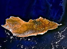
Landsat view over SocotraGeography Location Indian Ocean Coordinates 12°30′36″N 53°55′12″E / 12.51°N 53.92°ECoordinates: 12°30′36″N 53°55′12″E / 12.51°N 53.92°E Archipelago Socotra islands Total islands 4 Major islands Socotra, Abd al Kuri, Samhah, Darsah Area 3,796 km2 (1,465.6 sq mi) Highest elevation 1,503 m (4,931 ft) Highest point unnamed point in the Haghier Mountains Country YemenGovernorate Hadhramaut Districts Hadibu (east)
Qulansiyah wa 'Abd-al-Kūrī (west)Largest city Hadibu (pop. 8,545) Demographics Population 42,842 (as of 2004 census) Density 11.3 /km2 (29.3 /sq mi) Ethnic groups predominantly Arab; but also Afro-Arab, South Asian, Somali and European Additional information Official name: Socotra Archipelago Type: Natural Criteria: x Designated: 2008 (32nd session) Reference #: 1263 State Party:  Yemen
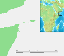
YemenRegion: Arab States Socotra (Arabic: سُقُطْرَى Suquṭra), also spelt Soqotra, is a small archipelago of four islands in the Indian Ocean. The largest island, also called Socotra, is about 95% of the landmass of the archipelago. It lies some 240 kilometres (150 mi) east of the Horn of Africa and 380 kilometres (240 mi) south of the Arabian Peninsula.[1] The island is very isolated and through the process of speciation, a third of its plant life is found nowhere else on the planet. It has been described as the most alien-looking place on Earth.[2]
Socotra is part of the Republic of Yemen. It had long been a part of the 'Adan Governorate, but in 2004 it became attached to the Hadhramaut Governorate, which is in much greater proximity to the island than 'Adan (although the nearest governorate is Al Mahrah).
Contents
History
There was initially an Oldoway (or Oldowan) culture in Socotra. Oldoway stone tools were found in the area around Hadibo by V.A. Zhukov, a member of the Russian Complex Expedition in 2008.[3][4]
Socotra appears as Dioskouridou ("of Dioscurides") in the Periplus of the Erythraean Sea, a 1st century AD Greek navigation aid. In the notes to his translation of the Periplus, G.W.B. Huntingford remarks that the name Socotra is not Greek in origin, but derives from the Sanskrit dvipa sukhadhara ("island of bliss").[5] A recent discovery of texts in several languages, including a wooden tablet in Palmyrene dated to the 3rd century AD, indicate the diverse origins of those who used Socotra as a trading base in antiquity.[6]
A local tradition holds that the inhabitants were converted to Christianity by Thomas the Apostle in AD 52. In the 10th century, the Arab geographer Abu Muhammad al-Hasan al-Hamdani stated that in his time most of the inhabitants were Christians.[citation needed] Socotra is also mentioned in The Travels of Marco Polo, according to which "the inhabitants are baptised Christians and have an 'archbishop'" who, it is further explained, "has nothing to do with the Pope in Rome, but is subject to an archbishop who lives at Baghdad". They were Nestorians but also practised ancient magic rituals despite the warnings of their archbishop.[7]
In 1507, a fleet commanded by Tristão da Cunha with Afonso de Albuquerque landed an occupying force at the then capital of Suq. Their objective was a Portuguese base to stop Arab commerce from the Red Sea to the Indian Ocean, and to liberate the presumed friendly Christians from Islamic rule. Here they started to build a fortress. However, they were not welcomed as enthusiastically as they had expected and abandoned the island four years later, as it was not advantageous as a base.[8] The island was also come across by Somali sailors.[citation needed]
The islands passed under the control of the Mahra sultans in 1511. Later, in January 1876, it became a British protectorate along with the remainder of the Mahra State of Qishn and Socotra. For the British it was an important strategic stop-over.[citation needed] The P&O ship Aden sank after being wrecked on a reef near Socotra, in 1897, with the loss of 78 lives.
In October 1967, the Mahra sultanate was abolished. On 30 November 1967, Socotra became part of the People's Republic of South Yemen (later to become the People's Democratic Republic of Yemen). Today it is part of the Republic of Yemen.
Somali pirates have begun using Socotra as a refueling stop for hijacked maritime vessels.[9]
Geography and climate
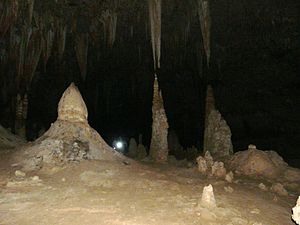
Halah Cave (كهف حالة) east of the island. Stalagmites and stalactites show how high it can reach compared to the 1.7 metres (5.6 ft) man with the torch. It is several hundred metres deep, with total darkness.
Socotra is one of the most isolated landforms on Earth of continental origin (i.e. not of volcanic origin).[citation needed] The archipelago was once part of the supercontinent of Gondwana and detached during the Miocene, in the same set of rifting events that opened the Gulf of Aden to its northwest.
The archipelago consists of the main island of Socotra (3,665 km2 (1,415 sq mi)), the three smaller islands of Abd al Kuri, Samhah and Darsa and small rock outcrops like Ka'l Fir'awn and Sābūnīyah that are uninhabitable by humans but important for seabirds.[10]
The main island has three geographical terrains: the narrow coastal plains, a limestone plateau permeated with karstic caves, and the Haghier Mountains.[11] The mountains rise to 1,503 metres (4,931 ft)[12]. The island is about 125 kilometres (78 mi) long and 45 kilometres (28 mi) north to south.[13]
The climate of Socotra is classified in the Köppen climate classification as BWh and BSh, meaning a tropical desert climate and semi-desert climate with a mean annual temperature over 18 °C (64 °F). Yearly rainfall is light, but is fairly spread throughout the year. Generally the higher inland areas receive more rain than the coastal lowlands, due to orographic lift provided by the interior mountains.[citation needed] The monsoon season brings strong winds and high seas.
Climate data for Socotra Month Jan Feb Mar Apr May Jun Jul Aug Sep Oct Nov Dec Year Average high °C (°F) 27.2
(81.0)28.5
(83.3)30.5
(86.9)32.7
(90.9)34.2
(93.6)33.9
(93.0)32.0
(89.6)32.3
(90.1)32.7
(90.9)31.4
(88.5)29.8
(85.6)28.0
(82.4)31.10
(87.98)Daily mean °C (°F) 22.0
(71.6)23.4
(74.1)25.1
(77.2)27.5
(81.5)28.9
(84.0)29.0
(84.2)27.6
(81.7)27.5
(81.5)27.6
(81.7)26.0
(78.8)24.2
(75.6)22.7
(72.9)25.96
(78.72)Average low °C (°F) 16.8
(62.2)18.3
(64.9)19.8
(67.6)22.2
(72.0)23.7
(74.7)24.1
(75.4)23.2
(73.8)22.8
(73.0)22.6
(72.7)20.6
(69.1)18.7
(65.7)17.5
(63.5)20.86
(69.54)Precipitation mm (inches) 23
(0.91)18
(0.71)14
(0.55)22
(0.87)37
(1.46)18
(0.71)12
(0.47)15
(0.59)27
(1.06)38
(1.5)18
(0.71)16
(0.63)258
(10.16)% humidity 23 18 14 22 37 18 12 15 27 38 18 16 21.5 Avg. precipitation days (≥ 0.0 mm) 2.0 2.0 2.1 3.4 4.1 6.0 9.7 9.3 4.9 3.2 3.0 3.0 52.7 Source: Climate of Socotra — Climatic Research Unit — University of East Anglia [1] Flora and fauna
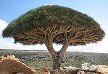
See also: List of spiders of SocotraEndemic tree species Dracaena cinnabari
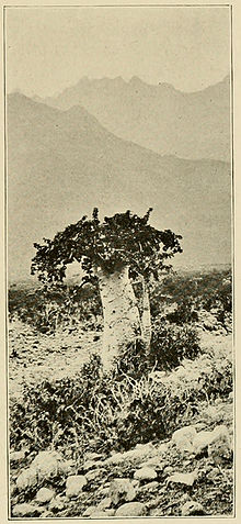 An 1890s photograph of endemic tree species Dendrosicyos socotrana, the cucumber tree, by Henry Ogg Forbes
Socotra is considered the jewel of biodiversity in the Arabian Sea.[14] The long geological isolation of the Socotra archipelago and its fierce heat and drought have combined to create a unique and spectacular endemic flora. Botanical field surveys led by the Centre for Middle Eastern Plants (part of the Royal Botanic Garden Edinburgh) indicate that 307 out of the 825 (37%) plant species on Socotra are endemic, i.e., they are found nowhere else on Earth.[15] The entire flora of the Socotra Archipelago has been assessed for the IUCN Red List, with 3 Critically Endangered and 27 Endangered plant species currently recognised.[15]
One of the most striking of Socotra's plants is the dragon's blood tree (Dracaena cinnabari), which is a strange-looking, umbrella-shaped tree. Its red sap was thought to be the dragon's blood of the ancients, sought after as a medicine and a dye,[citation needed] and today used as paint and varnish.[15] Also important in ancient times were Socotra's various endemic aloes, used medicinally, and for cosmetics. Other endemic plants include the giant succulent tree Dorstenia gigas, Moraceae, the cucumber tree Dendrosicyos socotranus, the rare Socotran pomegranate (Punica protopunica), Aloe perryi and Boswellia socotrana.[16]
The island group also has a rich bird fauna, including several endemic species of birds, such as the Socotra Starling (Onychognathus frater), the Socotra Sunbird (Nectarinia balfouri), Socotra Bunting (Emberiza socotrana), Island Cisticola (Cisticola haesitatus), Socotra Sparrow (Passer insularis) and Socotra Grosbeak (Rhynchostruthus socotranus), many of which are endangered by non-native feral cats.[17] There is even an endemic monotypic genus of birds, the Socotra Warbler (Incana incana).[16]
As with many isolated island systems, bats are the only mammals native to Socotra. In contrast, the coral reefs of Socotra are diverse, with many endemic species.[16] There is concern that introduced species, such as goats, may present a threat to the native flora of Socotra in the future.
UNESCO recognition
The island was recognised by the United Nations Educational, Scientific and Cultural Organization (UNESCO) as a world natural heritage site in July 2008. The European Union has supported such a move, calling on both UNESCO and International Organisation of Protecting Environment to classify the island archipelago among the environmental heritages.[18]
People and economy
The inhabitants are of Arab, Somali, and South Asian origins. They follow Islam and speak Soqotri, a Semitic language. Their primary occupations have been fishing, animal husbandry, and the cultivation of dates. Almost all inhabitants of Socotra, numbering nearly 50,000,[14] live on the homonymous main island of the archipelago. The principal city, Hadibu (with a population of 8,545 at the census of 2004); the second largest town, Qulansiyah (population 3,862); and Qād̨ub (population 929)[citation needed] are all located on the north coast of the island of Socotra. Only a few hundred people live on the islands of 'Abd-al-Kūrī and Samha; the island of Darsa and the islets of the archipelago are uninhabited.[citation needed]
The archipelago forms two districts of the Hadhramaut Governorate:
- the district of Hadibu (حديبو), with a population of 32,285 and a district seat at Hadibu, consists of the eastern two-thirds of the main island of Socotra;
- the district of Qulansiyah wa 'Abd-al-Kūrī (قلنسيه وعبد الكوري), with a population of 10,557 and a district seat at Qulansiyah, consists of the minor islands (the island of 'Abd-al-Kūrī chief among them) and the western third of the main island.
Monsoons long made the archipelago inaccessible from June to September each year. However, in July 1999, a new airport opened Socotra to the outside world year round, with both Yemen Airways and Felix Airways providing flights once a week to Aden and everyday to Sana'a. All flights stop at Riyan-Mukalla Airport (ICAO code "RIY"). Socotra Island Airport ("OYSQ") is located about 12 km (8 mi) west of the main city, Hadibu, and close to the third largest town in the archipelago, Qād̨ub.[19] Diesel generators make electricity widely available in Socotra, but even in Hadibu there is no electricity from 5:00 a.m. until 9:00 a.m. daily.[citation needed] An excellent paved road runs along the north shore from Qulansiyah to Hadibu and then to the DiHamri area; and another paved road, from the northern coast to the southern through the Dixsam Plateau.[citation needed] Public transport is limited in Socotra; taxis are available only as a kind of rent-a-car service of four-wheel-drive vehicles with drivers.[citation needed]
The former capital is located to the east of Hadibu. A small Yemeni Army barracks lies at the western end of Hadibu, and the President of Yemen, Ali Abdullah Saleh, has a residence there.[citation needed]
The Semitic language Soqotri, spoken originally only in Socotra, is related to such other Modern South Arabian languages on the Arabian mainland as Mehri, Harsusi, Bathari, Shehri, and Hobyot. Soqotri is also spoken by minority populations in the United Arab Emirates and other Gulf states.
Some residents raise cattle and goats. The chief export products of the island are dates, ghee, tobacco, and fish.
At the end of the 1990s, a United Nations Development Program was launched with the aim of providing a close survey of the island of Socotra.[citation needed]
The majority of male residents on Socotra are reported to be in the J* subclade of Y-DNA haplogroup J. Several of the female lineages on the island, notably those in mtDNA haplogroup N, are found nowhere else on earth.[citation needed]
Transport
Public transport on Socotra is limited to infrequent minibuses to Qulansiyah and to the villages on northeastern coast, car hire usually means hiring a 4WD car with driver.
Ships connect the only Socotra port – 5 km (3 mi) east of Hadibu – with the Yemeni coastal city of Al Mukalla. According to information from the ports, the journey takes 2–3 days and the service is used mostly for cargo.
Yemenia and Felix Airways fly from Socotra Airport to Sana'a and Aden via Al Mukalla (RIY — Riyan Airport). The Sana'a service operates daily, while Aden flights are on Mondays, as of December 2009.
Gallery
Notes
- ^ "Socotra islands scenery in Yemen". en.youth.cn. 25 April 2008. http://en.youth.cn/yculture/200911/t20091118_1085530.htm.
- ^ "The Most Alien-Looking Place on Earth". Dark Roasted Blend. 4 September 2008. http://www.darkroastedblend.com/2008/09/most-alien-looking-place-on-earth.html.
- ^ Amirkhanov, K.A.; Zhukov, V.A.; Haumkin, V.V.; Sedov, A.V. (2009). "Эпоха олдована открыта на острове Сокотра" (in Russian). Pripoda (7).
- ^ Davuov, O. M.; Shunkov, M. V.. "Международньій Симлозиум «Древнейшие Миграции Человека В Евразии» Махачкала, 6 – 12 сентября 2009 года". http://www.ihae.ru/konfer/simpozium.htm.
- ^ Huntingford, George Wynn Brereton (1980). The Periplus of the Erythraean Sea. Hakluyt Society. p. 103. ISBN 0-904180-05-0.
- ^ Sidebotham, Steven E. (2011). Berenike and the Ancient Maritime Spice Route. California. p. 189. ISBN 978-0-520-24430-6.
- ^ Polo, Marco (1958). The Travels of Marco Polo. Translated and with an Introduction by Ronald Latham. Penguin Books. ISBN 0-14-044057-7.
- ^ Diffie, Bailey Wallys; Winius, George Davison (1977). Foundations of the Portuguese empire, 1415–1580. University of Minnesota Press. p. 233. ISBN 0816607826. http://books.google.com/books?id=vtZtMBLJ7GgC&lpg=PP1&pg=PP1.
- ^ Saul, Jonathan (5 July 2011). "Somali pirates use Yemen island as fuel base". Reuters. http://af.reuters.com/article/topNews/idAFJOE7640BU20110705. Retrieved 30 August 2011.
- ^ Shobrak, Mohammed; Alsuhaibany, Abdullah; Al-Sagheir, Omer (November 2003). "Status of Breeding Seabirds in the Red Sea and Gulf of Aden" (in English and Arabic) (PDF). PERSGA/GEF Technical Series (Jeddah, Saudia Arabia: Regional Organization for Conservation of Environment of the Red Sea and Gulf of Aden (PERSGA)) (8). https://iodeweb1.vliz.be/odin/bitstream/1834/354/1/Tawfiq78.pdf.
- ^ "Socotra Fauna and Flora". http://www.socotraislandadventure.com/Socotra_%20fauna&flora.htm.
- ^ "Socotra High Point, Yemen". Peakbagger.com. http://www.peakbagger.com/peak.aspx?pid=11317. Retrieved 8 October 2011.
- ^ "Natural History". DBT Socotra Adventure Tour. http://www.socotraislandadventure.com/Socotra_%20fauna&flora.htm. Retrieved 8 October 2011.
- ^ a b FACTBOX-Socotra, jewel of biodiversity in Arabian Sea. Reuters, 2008-04-23
- ^ a b c Miller, A.G.; Morris, M. (2004). Ethnoflora of the Socotra Archipelago. Royal Botanic Garden Edinburgh.
- ^ a b c Kingdon, Jonathan (1989). Island Africa: The Evolution of Africa's Rare Plants and Animals. Princeton, New Jersey: Princeton University Press. pp. 38–42. ISBN 0-691-08560-9.
- ^ Burdick, Alan (25 March 2007). "The Wonder Land of Socotra". T Magazine. New York: New York Times. http://travel.nytimes.com/2007/03/25/travel/tmagazine/03well.socotra.t.html. Retrieved 9 November 2009.
- ^ "EU to protect Socotra archipelago environment". Saba Net. Yemen News Agency (SABA). 15 April 2008. http://www.sabanews.net/en/news151852.htm.
- ^ http://adds.aviationweather.gov/metars/stations.txt
References
- Agafonov, Vladimir (2006/07). "Temethel as the Brightest Element of Soqotran Folk Poetry". Folia Orientalia 42/43: 241–249.
- Biedermann, Zoltán (2006) (in German). Soqotra, Geschichte einer christlichen Insel im Indischen Ozean vom Altertum bis zur frühen Neuzeit. Maritime Asia 17. Wiesbaden: Harrassowitz Verlag. ISBN 978-3-447-05421-8.
- Botting, Douglas (2006) [1958]. Island of the Dragon's Blood (2nd ed.). ISBN 9781904246213.
- Burdick, Alan (25 March 2007). "The Wonder Land of Socotra, Yemen". The New York Times. http://travel.nytimes.com/2007/03/25/travel/tmagazine/03well.socotra.t.html?ex=1175572800&en=82b347ceafcb7cd8&ei=5070&emc=eta1.
- Casson, Lionel (1989). The Periplus Maris Erythraei. Princeton University Press. ISBN 0-691-04060-5.
- Cheung, Catherine; DeVantier, Lyndon (2006). Van Damme, Kay. ed. Socotra: A Natural History of the Islands and their People. Odyssey Books & Guides. ISBN 962-217-770-0.
- Doe, D. Brian (1970). Field, Henry; Laird, Edith M.. eds. Socotra: An Archaeological Reconnaissance in 1967. Miami: Field Research Projects.
- Doe, D. Brian (1992). Socotra: Island of Tranquility. London: Immel.
- Elie, Serge D. (November 2006). "Soqotra: South Arabia's Strategic Gateway and Symbolic Playground". British Journal of Middle Eastern Studies 33 (2): 131–160. doi:10.1080/13530190600953278. ISSN 1353-0194.
- Elie, Serge D. (2004). "Hadiboh: From Peripheral Village to Emerging City". Chroniques Yemenites 12.
- Elie, Serge D. (2008). "The Waning of Soqotra's Pastoral Community: Political Incorporation as Social Transformation". Human Organization 67 (3): 335–345.
- Elie, Serge D. (2009). "State-Community Relations in Yemen: Soqotra's Historical Formation as a Sub-National Polity". History and Anthropology 20 (4): 363–393.
- Elie, Serge D. (2010). "Soqotra: The Historical Formation of a Communal Polity". Chroniques Yéménites 16: 31–55.
- Elie, Serge D. The Waning of a Pastoralist Community: An Ethnographic Exploration of Soqotra as a Transitional Social Formation. D.Phil Dissertation, University of Sussex, June 2007. http://gateway.proquest.com/openurl?url_ver=Z39.88-2004&res_dat=xri:pqdiss&rft_val_fmt=info:ofi/fmt:kev:mtx:dissertation&rft_dat=xri:pqdiss:3392556.
- Miller, A.G. & Morris, M.(2004) Ethnoflora of the Socotra Archipelago. Royal Botanic Garden Edinburgh.
- Naumkin, V. V. and A. V. Sedov (1993). "Monuments of Socotra." In: Athens, Aden, Arikamedu: Essays on the interrelations between India, Arabia and the Eastern Mediterranean, pp. 193–250. Edited by Marie-Françoise Boussac and Jean-François Salles. First published in 1995 in Topoi, vol. 3/2 (1993), Lyons, France, pp. 387–623. Reprint 2005, by Ajay Kumar Jain for Manohar, Publishers, Delhi. ISBN 81-7304-079-6.
- RBGE Soqotra Bibliography: at RBGE and Friends of Soqotra websites.
- Schoff, Wilfred H. 1912. The Periplus of the Erythraean Sea. Longmans, Green, and Co., New York, Second Edition. Reprint: New Delhi, Oriental Books Reprint Corporation. 1974. (A new hardback edition is available from Coronet Books Inc. Also reprinted by South Asia Books, 1995, ISBN 81-215-0699-9)
External links
- Socotra Governance and Biodiversity Project. UNDP Yemen, 2008–2013
- LA Times photogallery of 11 images with descriptions, June 2009
- Royal Botanic Garden, Edinburgh: Soqotra's Misty Future. (See page 5 for information on dragons' blood).
- Regional Map of Socotra
- Global organisation of Friends for Soqotra in any aspect based in Edinburgh, Scotland.
- Audio interview with Soqotra resident about life in Soqotra
- Carter, Mike. The land that time forgot The Observer. Sunday April 16, 2006.
- A Historical Genealogy of Socotra as an Object of Mythical Speculation, Scientific Research & Development Experiment
- SCF Organisation.
- An article in T Style Magazine – NYTimes
- "Suḳuṭra" in the Encyclopaedia of Islam
Portuguese Empire North Africa15th century
1415–1640 Ceuta
1458–1550 Alcácer Ceguer (El Qsar es Seghir)
1471–1550 Arzila (Asilah)
1471–1662 Tangier
1485–1550 Mazagan (El Jadida)
1487– middle 16th century Ouadane
1488–1541 Safim (Safi)
1489 Graciosa16th century
1505–1769 Santa Cruz do Cabo
de Gué (Agadir)
1506–1525 Mogador (Essaouira)
1506–1525 Aguz (Souira Guedima)
1506–1769 Mazagan (El Jadida)
1513–1541 Azamor (Azemmour)
1515 São João da Mamora (Mehdya)
1577–1589 Arzila (Asilah)Sub-Saharan Africa15th century
1455–1633 Arguin
1470–1975 Portuguese São Tomé1
1474–1778 Annobón
1478–1778 Fernando Poo (Bioko)
1482–1637 Elmina (São Jorge
da Mina)
1482–1642 Portuguese Gold Coast
1496–1550 Madagascar (part)
1498–1540 Mascarene Islands16th century
1500–1630 Malindi
1500–1975 Portuguese Príncipe1
1501–1975 Portuguese E. Africa
(Mozambique)
1502–1659 St. Helena
1503–1698 Zanzibar
1505–1512 Quíloa (Kilwa)
1506–1511 Socotra
1557–1578 Portuguese Accra
1575–1975 Portuguese W. Africa
(Angola)
1588–1974 Cacheu2
1593–1698 Mombassa (Mombasa)17th century
1642–1975 Portuguese Cape Verde
1645–1888 Ziguinchor
1680–1961 São João Baptista de Ajudá
1687–1974 Portuguese Bissau2
18th century
1728–1729 Mombassa (Mombasa)
1753–1975 Portuguese São Tomé and Príncipe
19th century
1879–1974 Portuguese Guinea
1885–1975 Portuguese Congo1 Part of São Tomé and Príncipe from 1753. 2 Part of Portuguese Guinea from 1879. Southwest Asia16th century
1506–1615 Gamru (Bandar-Abbas)
1507–1643 Sohar
1515–1622 Hormuz (Ormus)
1515–1648 Quriyat
1515–? Qalhat
1515–1650 Muscat
1515?–? Barka
1515–1633? Julfar (Ras al-Khaimah)
1521–1602 Bahrain (Muharraq and Manama)
1521–1529? Qatif
1521?–1551? Tarut Island
1550–1551 Qatif
1588–1648 Matrah17th century
1620–? Khor Fakkan
1621?–? As Sib
1621–1622 Qeshm
1623–? Khasab
1623–? Libedia
1624–? Kalba
1624–? Madha
1624–1648 Dibba Al-Hisn
1624?–? Bandar-e KongIndian subcontinent15th century
1498–1545 Laccadive Islands
(Lakshadweep)16th century
Portuguese India
· 1500–1663 Cochim (Kochi)
· 1502–1661 Quilon (Coulão/Kollam)
· 1502–1663 Cannanore (Kannur)
· 1507–1657 Negapatam (Nagapatnam)
· 1510–1962 Goa
· 1512–1525 Calicut (Kozhikode)
· 1518–1619 Chaul
· 1523–1662 Mylapore
· 1528–1666 Chittagong
· 1531–1571 Chalium
· 1534–1601 Salsette Island
· 1534–1661 Bombay (Mumbai)
· 1535–1739 Baçaím (Vasai-Virar)
· 1536–1662 Cranganore (Kodungallur)
· 1540–1612 Surat
· 1548–1658 Tuticorin (Thoothukudi)16th century (continued)
Portuguese India (continued)
· 1559–1962 Daman and Diu
· 1568–1659 Mangalore
· 1579–1632 Hugli
· 1598–1610 Masulipatnam (Machilipatnam)
1518–1521 Maldives
1518–1658 Portuguese Ceylon (Sri Lanka)
1558–1573 Maldives
17th century
Portuguese India
· 1687–1749 Mylapore
18th century
Portuguese India
· 1779–1954 Dadra and Nagar HaveliEast Asia and Oceania16th century
1511–1641 Portuguese Malacca
1512–1621 Ternate
· 1576–1605 Ambon
· 1578–1650 Tidore
1512–1665 Makassar
1553–1999 Portuguese Macau
1571–1639 Decima (Dejima, Nagasaki)17th century
1642–1975 Portuguese Timor (East Timor)1
19th century
Portuguese Macau
· 1864–1999 Coloane
· 1849–1999 Portas do Cerco
· 1851–1999 Taipa
· 1890–1999 Ilha Verde
20th century
Portuguese Macau
· 1938–1941 Lapa and Montanha (Hengqin)1 1975 is the year of East Timor's Declaration of Independence and subsequent invasion by Indonesia. In 2002, East Timor's independence was recognized by Portugal & the world.
North America and the North Atlantic Ocean16th century
1500–1579? Terra Nova (Newfoundland)
1500–1579? Labrador
1516–1579? Nova ScotiaCentral and South America16th century
1500–1822 Brazil
1536–1620 Portuguese Barbados17th century
1680–1777 Nova Colônia do Sacramento
19th century
1808–1822 Cisplatina (Uruguay)Categories:- Socotra Archipelago
- Hadhramaut Governorate
- Islands of Yemen
- Islands of Africa
- Gulf of Aden
- Islands of the Indian Ocean
- World Heritage Sites in Yemen
- Biosphere reserves of Yemen
- Archipelagoes of the Indian Ocean
- Archaeological sites in Yemen
Wikimedia Foundation. 2010.

