- Mascarene Islands
-
Mascarene Islands Native name: Mascareignes 
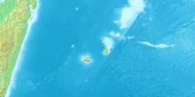
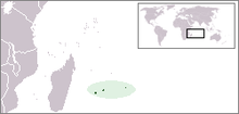
Topographic map of Mascarene IslandsGeography Major islands Mauritius, Réunion, Rodrigues Country The Mascarene Islands (or Mascarenhas Archipelago) is a group of islands in the Indian Ocean east of Madagascar comprising Mauritius, Réunion, Rodrigues, Cargados Carajos shoals, plus the former islands of the Saya de Malha, Nazareth and Soudan banks. The collective title is derived from the Portuguese navigator Pedro Mascarenhas, who first visited them in the early sixteenth century. The islands share a common geologic origin in the volcanism of the Réunion hotspot beneath the Mascarene Plateau and form a distinct ecoregion with a unique flora and fauna.
Contents
Nature
Geology
The Islands are volcanic in origin; Saya de Malha (35 mya) was the first of the Mascarene islands to rise out of the Indian Ocean due to the Réunion hotspot, followed by Nazareth Bank (some 2,000 yrs later), Soudan Bank and Cargados Carajos. The youngest islands to form were Mauritius (7-10 mya), the oldest of the existing islands, created along with the undersea Rodrigues ridge. The islands of Rodrigues and Réunion were created in the last two million years. Réunion is the largest of the islands (2,500 km²), followed by Mauritius (1,900 km²) and Rodrigues (110 km²). Eventually Saya de Malha, Nazareth and Soudan were completely submerged, Cargados Carajos remaining as a coral atoll.[1] The Réunion hotspot was beginning to cool and Rodrigues came out as a tiny island. Had erosion not taken place, Cargados Carajos would have been a large volcanic island, and the Mascarenes would have been an archipelago of seven or more (counting Saya De Malha, Nazareth and Soudan) large, populated islands, rather than the three (Mauritius, Reunion, Rodrigues) that remain today.
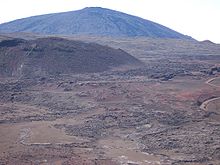
Réunion is home to the highest peaks in the Mascarenes, the shield volcanoes Piton des Neiges (3,069 m) and Piton de la Fournaise (2,525 m). Piton de la Fournaise, on the southeastern corner of Réunion, is one of the most active volcanoes in the world, erupting last on January 2, 2010. Piton de la Petite Rivière Noire (828 m) is the highest peak on Mauritius, and the gentle hills of Rodrigues rise to only 390 m.
The Mascarene Plateau is an undersea plateau that extends approximately 2000 km, from the Seychelles to Réunion. The plateau covers an area of over 115,000 km² of shallow water, with depths ranging from 8 to 150 meters, plunging to 4000 m to the abyssal plain at its edges. The southern part of the plateau, including the Saya de Malha Bank, Nazareth Bank, Soudan Banks and Cargados Carajos Shoals (Saint Brandon) (then one large island), was formed by the Réunion hotspot. These were once volcanic islands, much like Mauritius and Réunion, which have now sunk or eroded to below sea level or, in the case of the Cargados Carajos, to low coral islands. The Saya de Malha Bank formed 35 million years ago, and the Nazareth Bank and the Cargados Carajos shoals after that. Limestone banks found on the plateau are the remnants of coral reefs, indicating that the plateau was a succession of islands. Some of the banks may have been islands as recently as 18,000 - 6,000 years ago, when sea levels were as much as 130 meters lower during the most recent ice age.
Mascarene forests
The Mascarene islands form a distinct ecoregion, known as the Mascarene forests. The islands were formerly covered in tropical moist broadleaf forest and harbored a diverse range of forest types. Near the seacoast were coastal wetlands and swamp forests, transitioning to rain forest to windward and lowland dry forest to leeward, palm savannas, montane deciduous forests, and montane heathlands on the highest peaks of Réunion.
The islands are home to many endemic plants and animals. Most of the Mascarene flora and fauna is thought to be derived originally from Madagascar and Africa. The islands have never been connected to the mainland, so the flora and fauna of the Mascarenes arrived from over the sea. Prehistoric islands of the Mascarene Plateau, now disappeared under the sea, may have served as 'stepping stones' which allowed species to island-hop from the Seychelles or Madagascar. The Mascarenes are home to one endemic family of flowering plants, Psiloxylaceae, which has only one species, Psiloxylon mauritianum. Until Europeans first settled the islands in the sixteenth century, no peoples were known to exist in the Mascarenes, so much of the island's wildlife, which would have gone extinct much earlier had any native people lived there, were still flourishing during the early days of settling.
The islands have no native mammals, except for bats. Sixteen endemic bird species survive on the islands. Many of the Mascarene birds evolved into flightless forms; the most famous of which was the Dodo, an extinct flightless pigeon of Mauritius. Mauritius, Réunion, and Rodrigues were also once each home to one or more species of giant tortoises, now extinct, which comprised the genus Cylindraspis. There are thirteen living endemic reptile species, including a number of species of day geckoes (genus Phelsuma).
Much of the Mascarenes' native flora and fauna has become endangered or extinct since the human settlement of the islands in the 17th century. Settlers cleared most of the forests for agriculture and grazing, and introduced many exotic species, including pigs, rats, cats, monkeys, and mongooses. As well as the tortoises and the Dodo, thirteen additional species of birds became extinct, including the Rodrigues Solitaire, a flightless pigeon related to the Dodo, and the Réunion Flightless Ibis.
The Tambalacoque (Sideroxylon grandiflorum), often called the dodo tree, is also threatened with extinction, although this is principally as a result of unripened seed destruction by the introduced crab-eating macaque (Macaca fascicularis) rather than any connection to a reliance on the dodo to assist with seed germination after the seeds passed through the extinct bird's digestive tract.
Historical colonies
The early colonial history of the islands, like that of the Caribbean, is a confusing story of takeovers between the rival Portuguese, Dutch, French and British colonizers, usually separate or in varying combinations, sometimes even with distant other colonies, e.g. in the East Indies.
Around 1507, the explorer Mascarenhas discovered the island group which bears his name. The area remained under nominal Portuguese rule until Étienne de Flacourt arrived with a French naval squadron and took possession in 1649.[2] From 4 June 1735 to 23 March 1746, a single French Mascarene Islands chartered colony under one gouverneur général (governor general) contained Île de France (Mauritius), Île Bourbon (Réunion) and Séchelles (Seychelles). On 14 July 1767 this became a French crown colony, still under one governor general. From 3 February 1803 till 2 September 1810 the French colony of Indes-Orientales, under a capitaine général (captain-general), included Réunion and (nominally) the Seychelles.
Islands and Banks
Mauritius
Mauritius was formed 8-10 million years ago, and is geographically one of the oldest remaining islands in the group. It was discovered in the 10th century by the Arabs and was first named Dina Harobi, but the first permanent settlement was by the Dutch in 1638. It was seized by France in 1715, who remained in control of it until the British took over in 1810. Mauritius gained independence in 1968.
Rodrigues
Rodrigues was formed at around the same time as Mauritius. It was first discovered by the Arabs but named after Portuguese navigator Diogo Rodrigues. It was under Dutch control in 1601 and settled by the French in 1691. Britain took possession of Rodrigues in 1809. When Mauritius gained independence in 1968, Rodrigues was forcefully joined to it. Rodrigues remains an autonomous region of Mauritius.
Réunion
Réunion was discovered first by the Arabs then by the Portuguese, who named it Santa Apolónia. It was then occupied by the French as part of Mauritius. It was first inhabited by French mutineers who arrived on the island between 1646 and 1669.[3] It was given its current name in 1793. From 1810 to 1815 it was held by the British, before being returned to France. Réunion became an overseas department of France in 1946.
Cargados Carajos
Cargados Carajos is the remnant of one or more large volcanic islands which sank with the rising tides. Today it is administered by Mauritius.
Saya de Malha
Saya de Malha Bank is a large, submerged bank. Historically it was a group of volcanic islands, and was joined to the Great Chagos Bank until continental drift pushed them apart.
Soudan Banks
Soudan Banks are a group of low-lying banks on the Mascarene Plateau.
Nazareth Bank
Nazareth Bank is located just north of Cargados Carajos, and historically they were a single geological feature. Today it is a large, shallow fishing bank.
Hawkins Bank
Hawkins Bank is located on the northernmost point of the Mascarene Plateau.
References
- ^ http://www.phelsumania.com/public/articles/biogeography_dispersal_mascarenes.html
- ^ Moriarty, Cpt. H.A. (1891). Islands in the southern Indian Ocean westward of Longitude 80 degrees east, including Madagascar. London: Great Britain Hydrographic Office. p. 269. OCLC 416495775. http://books.google.com/books?id=-NmhAAAAMAAJ&pg=PA269#v=onepage&q&f=false. Retrieved 11 June 2011.
- ^ http://documents.irevues.inist.fr/bitstream/handle/2042/14363/HERMES_2002_32-33_91.pdf?sequence=1
- Quammen, David, (1996) The Song of the Dodo. Touchstone, New York.
- Diamond, Jared, (1984) "Historic extinctions: A rosetta stone for understanding prehistoric extinctions". In: P. Martin and R. Klein (eds.) (1984) Quaternary Extinctions: A prehistoric revolution. University of Arizona Press, Tucson.
- WorldStatesmen- under Mauritius
External links
- Scientific research application on the nature reserve of Mare-Longue (Réunion - Mascarene Islands)
- Mascarene forests (World Wildlife Fund)
- Dispersal of the Genus Phelsuma in the Mascarenes (Phelsumania)
History of Africa Sovereign
states- Algeria
- Angola
- Benin
- Botswana
- Burkina Faso
- Burundi
- Cameroon
- Cape Verde
- Central African Republic
- Chad
- Comoros
- Democratic Republic of the Congo
- Republic of the Congo
- Côte d'Ivoire (Ivory Coast)
- Djibouti
- Egypt
- Equatorial Guinea
- Eritrea
- Ethiopia
- Gabon
- The Gambia
- Ghana
- Guinea
- Guinea-Bissau
- Kenya
- Lesotho
- Liberia
- Libya
- Madagascar
- Malawi
- Mali
- Mauritania
- Mauritius
- Morocco
- Mozambique
- Namibia
- Niger
- Nigeria
- Rwanda
- São Tomé and Príncipe
- Senegal
- Seychelles
- Sierra Leone
- Somalia
- South Africa
- South Sudan
- Sudan
- Swaziland
- Tanzania
- Togo
- Tunisia
- Uganda
- Zambia
- Zimbabwe
States with limited
recognition- Sahrawi Arab Democratic Republic
- Somaliland
Dependencies and
other territories- Canary Islands / Ceuta / Melilla / Plazas de soberanía (Spain)
- Madeira (Portugal)
- Mayotte / Réunion (France)
- Saint Helena / Ascension Island / Tristan da Cunha (United Kingdom)
- Western Sahara
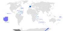
French overseas empire Former Former French colonies in Africa and the Indian Ocean Maghreb - Algeria
- Morocco (Arguin Island)
- Tunisia
French West Africa French Equatorial Africa Comoros - French Somaliland (Djibouti)
- Madagascar
- Ile de France
- Seychelles
Former French colonies in the Americas Inini · Berbice · Saint-Domingue (Haiti) · Tobago · Virgin Islands · France Antarctique · Equinoctial FranceFormer French colonies in Asia and Oceania French India Indochinese Union French Mandate for Syria and the Lebanon Oceania Present  Overseas departments and territories of France
Inhabited areas  Special status
Uninhabited areas Pacific Ocean French Southern and
Antarctic LandsBanc du Geyser4 · Bassas da India4 · Europa Island4 · Glorioso Islands3, 4, 5 · Juan de Nova Island4 · Tromelin Island4, 51 Also known as overseas regions. 2 Claimed by Comoros. 3 Claimed by Madagascar. 4 Claimed by Seychelles. 5 Claimed by Mauritius.Portuguese Empire North Africa15th century
1415–1640 Ceuta
1458–1550 Alcácer Ceguer (El Qsar es Seghir)
1471–1550 Arzila (Asilah)
1471–1662 Tangier
1485–1550 Mazagan (El Jadida)
1487– middle 16th century Ouadane
1488–1541 Safim (Safi)
1489 Graciosa16th century
1505–1769 Santa Cruz do Cabo
de Gué (Agadir)
1506–1525 Mogador (Essaouira)
1506–1525 Aguz (Souira Guedima)
1506–1769 Mazagan (El Jadida)
1513–1541 Azamor (Azemmour)
1515 São João da Mamora (Mehdya)
1577–1589 Arzila (Asilah)Sub-Saharan Africa15th century
1455–1633 Arguin
1470–1975 Portuguese São Tomé1
1474–1778 Annobón
1478–1778 Fernando Poo (Bioko)
1482–1637 Elmina (São Jorge
da Mina)
1482–1642 Portuguese Gold Coast
1496–1550 Madagascar (part)
1498–1540 Mascarene Islands16th century
1500–1630 Malindi
1500–1975 Portuguese Príncipe1
1501–1975 Portuguese E. Africa
(Mozambique)
1502–1659 St. Helena
1503–1698 Zanzibar
1505–1512 Quíloa (Kilwa)
1506–1511 Socotra
1557–1578 Portuguese Accra
1575–1975 Portuguese W. Africa
(Angola)
1588–1974 Cacheu2
1593–1698 Mombassa (Mombasa)17th century
1642–1975 Portuguese Cape Verde
1645–1888 Ziguinchor
1680–1961 São João Baptista de Ajudá
1687–1974 Portuguese Bissau2
18th century
1728–1729 Mombassa (Mombasa)
1753–1975 Portuguese São Tomé and Príncipe
19th century
1879–1974 Portuguese Guinea
1885–1975 Portuguese Congo1 Part of São Tomé and Príncipe from 1753. 2 Part of Portuguese Guinea from 1879. Southwest Asia16th century
1506–1615 Gamru (Bandar-Abbas)
1507–1643 Sohar
1515–1622 Hormuz (Ormus)
1515–1648 Quriyat
1515–? Qalhat
1515–1650 Muscat
1515?–? Barka
1515–1633? Julfar (Ras al-Khaimah)
1521–1602 Bahrain (Muharraq and Manama)
1521–1529? Qatif
1521?–1551? Tarut Island
1550–1551 Qatif
1588–1648 Matrah17th century
1620–? Khor Fakkan
1621?–? As Sib
1621–1622 Qeshm
1623–? Khasab
1623–? Libedia
1624–? Kalba
1624–? Madha
1624–1648 Dibba Al-Hisn
1624?–? Bandar-e KongIndian subcontinent15th century
1498–1545 Laccadive Islands
(Lakshadweep)16th century
Portuguese India
· 1500–1663 Cochim (Kochi)
· 1502–1661 Quilon (Coulão/Kollam)
· 1502–1663 Cannanore (Kannur)
· 1507–1657 Negapatam (Nagapatnam)
· 1510–1962 Goa
· 1512–1525 Calicut (Kozhikode)
· 1518–1619 Chaul
· 1523–1662 Mylapore
· 1528–1666 Chittagong
· 1531–1571 Chalium
· 1534–1601 Salsette Island
· 1534–1661 Bombay (Mumbai)
· 1535–1739 Baçaím (Vasai-Virar)
· 1536–1662 Cranganore (Kodungallur)
· 1540–1612 Surat
· 1548–1658 Tuticorin (Thoothukudi)16th century (continued)
Portuguese India (continued)
· 1559–1962 Daman and Diu
· 1568–1659 Mangalore
· 1579–1632 Hugli
· 1598–1610 Masulipatnam (Machilipatnam)
1518–1521 Maldives
1518–1658 Portuguese Ceylon (Sri Lanka)
1558–1573 Maldives
17th century
Portuguese India
· 1687–1749 Mylapore
18th century
Portuguese India
· 1779–1954 Dadra and Nagar HaveliEast Asia and Oceania16th century
1511–1641 Portuguese Malacca
1512–1621 Ternate
· 1576–1605 Ambon
· 1578–1650 Tidore
1512–1665 Makassar
1553–1999 Portuguese Macau
1571–1639 Decima (Dejima, Nagasaki)17th century
1642–1975 Portuguese Timor (East Timor)1
19th century
Portuguese Macau
· 1864–1999 Coloane
· 1849–1999 Portas do Cerco
· 1851–1999 Taipa
· 1890–1999 Ilha Verde
20th century
Portuguese Macau
· 1938–1941 Lapa and Montanha (Hengqin)1 1975 is the year of East Timor's Declaration of Independence and subsequent invasion by Indonesia. In 2002, East Timor's independence was recognized by Portugal & the world.
North America and the North Atlantic Ocean16th century
1500–1579? Terra Nova (Newfoundland)
1500–1579? Labrador
1516–1579? Nova ScotiaCentral and South America16th century
1500–1822 Brazil
1536–1620 Portuguese Barbados17th century
1680–1777 Nova Colônia do Sacramento
19th century
1808–1822 Cisplatina (Uruguay)Categories:- East Africa
- Islands of Africa
- Afrotropic
- Former Portuguese colonies
- Former colonies of France
- Tropical and subtropical moist broadleaf forests
- Volcanic arc islands
- Archipelagoes of the Indian Ocean
- Islands of the Indian Ocean
Wikimedia Foundation. 2010.


