- Glorioso Islands
Infobox Country
native_name = "Îles Glorieuses"
conventional_long_name = Glorioso Islands
common_name = Archipel des Glorieuses

symbol_type = Coat of arms
national_motto = "Liberté, égalité, fraternité " (English: "Liberty, Equality, Brotherhood")
national_anthem =La Marseillaise 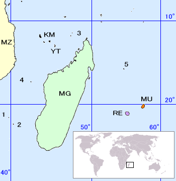
map_caption = Location of theScattered islands in the Indian Ocean :
• 1 :Bassas da India • 2 :Europa Island • 3 :Glorioso Islands • 4 :Juan de Nova Island • 5 :Tromelin Island (KM :Comoros , MG :Madagascar , MU :Mauritius , MZ :Mozambique , RE :Réunion , YT :Mayotte ).
The
archipelago consists of two islands, Grande Glorieuse and Île du Lys, as well as eight rock islets ("Roches Vertes"): Wreck Rock, South Rock and Verte Rocks (three) and three others that are unnamed. They form part of acoral reef andlagoon . Grande Glorieuses is roughly circular and measures about 3 km across. It is thickly vegetated, mainly by the remains of a coconut plantation andcasuarina trees.Île du Lys, about five miles northeast of Grande Glorieuses, is about 600 metres long and consists of
sand dunes and scrub with somemangroves . It was formerly quarried forphosphate (guano ).The Glorieuses were named and settled in 1880 by a
Frenchman , Hippolyte Caltaux, who established acoconut andmaize plantation on Grande Glorieuse. The archipelago became a French possession in 1892. From 1914 to 1958 concessions to exploit the islands were given toSeychelles companies.The islands are today
nature reserves with ameteorological station garrisoned by French troops (TheFrench Foreign Legion ). They are claimed byMadagascar (because of their strategic importance), theSeychelles (considering the islands part of theSeychelles Archipelago ) and theComoros (considering the islands part of the Comoros Archipelago).The climate is tropical and the terrain is low and flat, varying from sea level to 12 m. Île de Lys in particular is a nesting ground for migratory
seabirds , andturtles lay eggs on the beaches.

Wikimedia Foundation. 2010.