- Comoro Islands
-
Comoro Islands Native name: Komori :جزر القمر (Arabic)
Archipel des Comores (French)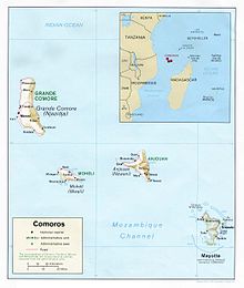
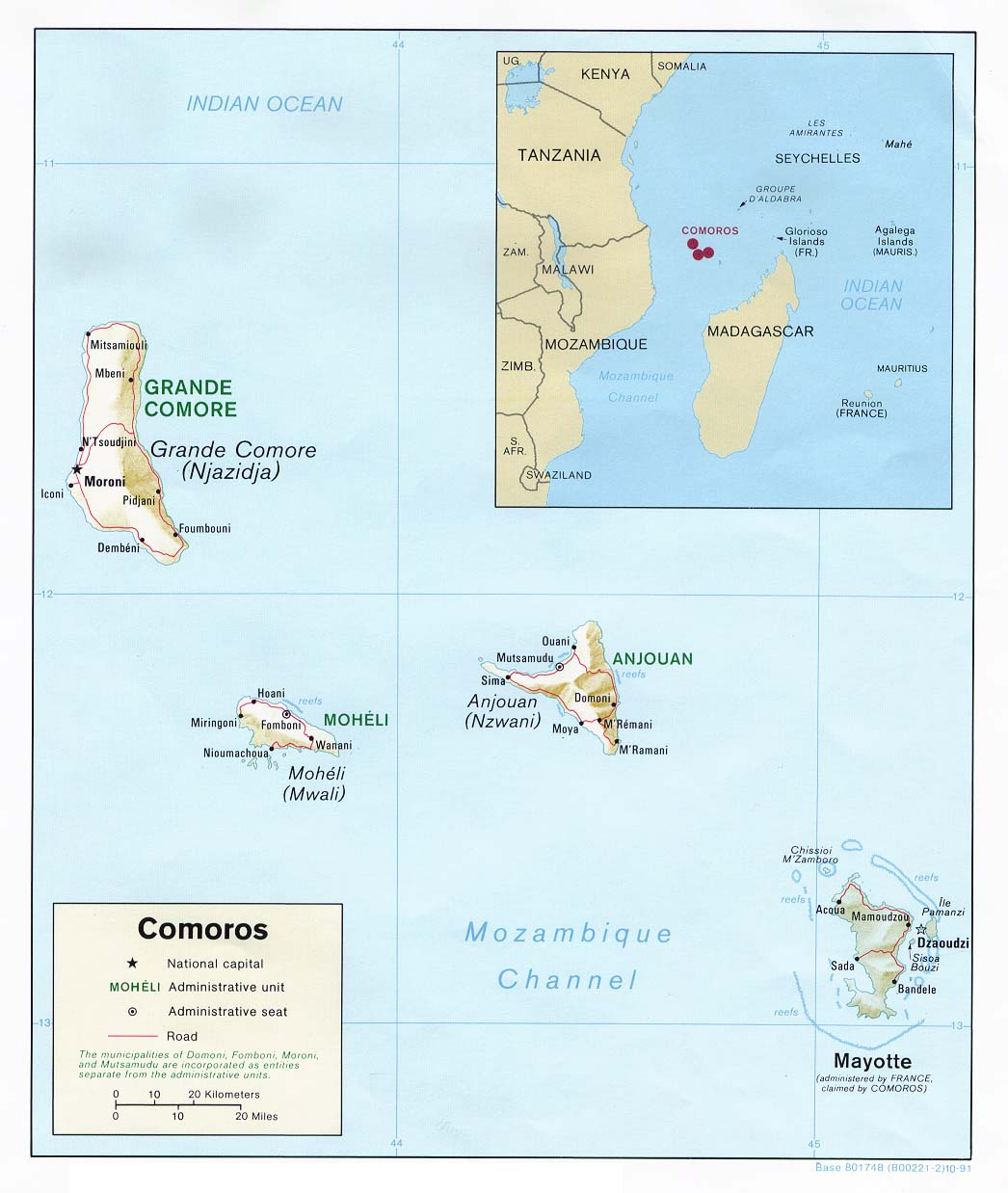
Geography Location Indian Ocean Coordinates 12°08′24″S 44°15′00″E / 12.14°S 44.25°ECoordinates: 12°08′24″S 44°15′00″E / 12.14°S 44.25°E Total islands 5 Major islands Grande Comore (Ngazidja)
Mohéli (Mwali)
Anjouan (Nzwani)
MayotteArea 2,236 km2 (863.3 sq mi) Highest elevation 2,361 m (7,746 ft) Highest point Kartala Country ComorosIslands Grande Comore (Ngazidja)
Mohéli (Mwali)
Anjouan (Nzwani)Largest city Moroni (pop. 60,200) President Ikililou Dhoinine FranceOverseas collectivity Mayotte Largest city Mamoudzou (53,022) Demographics Population 984,500 The Comoros Islands (Shikomori Komori; Arabic جزر القمر Juzur al-Qamar; French Les Comores) form an archipelago of volcanic islands situated off the south-east coast of Africa, to the east of Mozambique and north-west of Madagascar. They are divided between the sovereign state of Comoros and the French overseas department of Mayotte. The islet of Banc du Geyser and the Glorioso Islands are sometimes included as part of the archipelago.
Contents
Geography
Main article: Geography of ComorosThe Comoros are located in the Mozambique Channel to the north-west of Madagascar and facing Mozambique. These four volcanic islands, covering a total area of 2034 km², are:
- Ngazidja (or Grande Comore): the largest island, with the capital of the Union of the Comoros, Moroni
- Ndzwani (or Anjouan)
- Mwali (or Mohéli)
- Maore (or Mayotte): under French administration, and including
- Pamanzi (or Petite Terre) Mayotte's second-largest island. Supports Mayotte's only airport in Dzaoudzi
- Banc Vailheu, or Raya, lies 20 km west of Grande Comore, is within 7 m of the surface at low tide.
Two islets, have been considered part of this archipelago, by various sources, and at different times:
- The Banc du Geyser, a reef measuring 8 by 5 km in area, some parts of which are emergent, situated 130 km Northe North-East of Mayotte. It is claimed by Comoros, France and Madagascar.
- The Glorioso Islands (French Îles Glorieuses) were administratively attached to the archipelago before 1975, and, geologically speaking, form a part of the archipelago.
In addition, between Madagascar and Mayotte, there is the Banc du Leven, a former island which is submerged these days.
"The affinity between the Comorian flora and the Madagascan flora is certain. The presence of the Banc du Leven, along about one hundred kilometres to the extreme north-west of Madagascar between the Montagne d'Ambre and the archipelago could partly explain this affinity. In fact, this bank with a tabular appearance presents coralligenous sediments which can be attributed to the presence of a coral reef during the Würm glaciation.[1]" — Callmander, M.W. 2002. Biogéographie et systématique des Pandanaceae de l’Océan Indien occidental. Doctoral Thesis, University of Neuchâtel, 253 p.
Politically, the islands are currently divided into two entities:
- The Comoros, a sovereign state
- Mayotte, an overseas department of France
The Union of the Comoros is recognized as including the three northernmost islands. Anjouan and Mohéli declared their independence in 1997, however these unilateral declarations of independence received no international recognition and were later rescinded.
Grande Comore is the youngest of the islands, and has a massive active volcano on it, which scientists predict is likely to erupt in the near future.
History
The first traces of inhabitation date back to the 6th century. Since then, numerous ethnicities have crossed over and mixed, among which are populations of Bantu, Malagasy, Indonesian, Arab, Portuguese, French and Indian origin. Islam arrived here in the 10th Century. These islands formed with Zanzibar, Pemba, Lamu, and the towns along the Kenyan and Tanzanian coast a united and prosperous area with Swahili culture, living by trading slaves, ivory and other African goods destined for markets in the Middle East and India. During this period, power was in the hands of a number of local rulers. During their explorations of all this region, the Portuguese discovered and landed on the Islands of the Moon (qamar in Arabic means "moon") in 1505.
Between 1841 and 1912, the French subdued the islands in a series of a number of incredible moves (???) mixing, just like in Madagascar, acts of war, treachery and love stories (???). They succeeded in establishing protectorates and then a colony administered by the Governor General of Madagascar. The European powers recognised the French influence over the islands after the Berlin conference of 1884-85 which divided up Africa.[2] The islands were constituted as a French colony in 1908 but attached to Madagascar in 1912.
Since the workforce on Réunion was becoming increasingly more expensive, the Comoro Islands, forgotten by the central administration, offered the colonists and colonial societies (like la Bambao) various perspectives and a workforce in plantations of aromatic plants and vanilla. In 1946, the islands were no longer administratively attached to Madagascar and formed a united and recognized administrative entity, an Overseas Territory of France (Territoire d'outre-mer or TOM).[2]
In 1974, France organized a referendum for self-determination in the archipelago in which the population voted overwhelmingly in favour of independence. However, following the unilateral declaration of independence in 1975, France refused to recognise Comorian sovereignty over Mayotte, where a majority had voted no in the referendum. The three remaining islands formed the Etat Comorian, which later became the Federal Islamic Republic of the Comoro Islands.
In 1997, demands for increased autonomy on the islands of Nzwani (Anjouan) and Mwali (Moheli) led to the breakup of the Federal Islamic Republic. The government reformed under a new constitution in 2001 as the Union of the Comoros. The new constitution gave each of the three islands more autonomy than had been enjoyed previously. However, national authority over the islands was confirmed following the refusal of the President of Anjouan to hold free elections in 2008, and he was forced to flee by military intervention by troops of the Comorian Union and the African Union. The island continues its present form of confederal government albeit with minor changes approved in a 2009 referendum.[2]
Mayotte, which had voted to retain French suzerainty in the 1975 referendum, expressed a wish to accede to the status of a département d'outre-mer (DOM) (Overseas Department) following another referendum held on the island on the 29 March 2009.[2] Mayotte officially became France's 101st department on 31 March 2011.
On 30 June 2009, Yemenia Flight 626 crashed off the Comoros Islands. Out of 153 people, one survived.
Geology
The Comoro Archipelago consists of volcanic islands. These volcanic islands like some of the high mountains in the north of Madagascar were formed in the Tertiary and Quaternary Eras. The island of Mayotte is the oldest one still above sea level and underwent three volcanic phases between 15 million and 500,000 years ago. The ages progressively decrease from east to west. The most recent island is that of Grande Comore, and its volcano, Karthala, is still active. The summit caldera is quite large, being approximately 3 x 4 km (1.9 x 2.5 miles) in size at the rim (2007).[3]
Climate
Main article: Climate of ComorosThe Comoro Archipelago enjoys a tropical maritime climate, characterized by slight daytime temperature variations throughout the year of around 26 °C (78.8 °F) at sea-level and by abundant precipitation: 2,679 mm (105.5 in) a year. The average temperature of the sea water is 25 °C (77 °F). There are two seasons in the Comoros: the hot and humid season flowing in from the north-west from November to April and the dry season from May to October. The climate on Mayotte is, nevertheless, noticeably warmer and drier. The climate is also characterized by important local variations in temperature and precipitation according to altitude, relief and the degree of exposure to the elements. Annual precipitation therefore varies in the region of 1,000 to 6,000 mm (39.4 to 236.2 in) and the absolute minimum of 0 °C (32 °F) is reached on the summit of Karthala.
The hot, dry season is caused by a vast low pressure area which extends over a large part of the Indian Ocean and Central Africa. This low pressure favours gusty winds and cyclones. The last cyclone was "Gafilo" which passed close to the Comoros on the 5th of March 2004 causing great material damage. During the hot and humid season it can rain as much as 200 mm (7.9 in) in twenty-four hours. The dry season is calmer. The low pressure moves towards the continent of Asia (this is the Monsoon, the wind blowing from the south-east) and an anticyclone forms below the Comoros. This still does not prevent the islands from having a few gusts of wind, but their intensity is a lot less than during the hot season.
The two winds that bring the two different seasons are called the Kashkasi (in November) and the Kusi.
Flora and fauna
Several mammals are endemic to the islands. The Maki of Mayotte, a type of lemur which is only found on this island, is protected by French law, and by local tradition. A species of bat discovered by David Livingstone in 1863, previously abundant, has now been reduced to a population of about 1200 specimens, restricted to Anjouan and Moheli. A British preservation group sent an expedition to the Comoros in 1992, with the object of transporting some specimens to Great Britain, in order to form a reproducing colony.
Twenty-two species of birds are endemic to the archipelago, and seventeen of them only live on territories controlled by the Union; especially notable examples of these are the Karthala Scops-Owl, the Anjouan Scops-Owl and the Moucherolle of Humblot.
Partly as a result of international pressure during the 1990s, the government of the Union has begun to take greater care of the environment. Measures have been taken not only to preserve the rare fauna, but also to check the destruction of the environment, especially on Anjouan, which is densely populated. More precisely, in order to minimize the felling of trees for fuel, kerosene has been subsidized, and efforts are underway to replace the lost forest cover caused by the distillation of Ylang-ylang for perfume. The Fund for the Support of Community Development, sponsored by the International Development Association (IDA, a subsidiary of the World Bank) and the Comorian government, is applying itself to improving the water supply on the islands.
Fauna
Like other islands in the region, these islands possess numerous endemic species; here are some of the most notable species:
- Livingstone's Fruit Bat : a very large endemic daytime bat, which eats fruit.
- The Maki : a type of small lemur (Kima in Shikomori)
- Scolopendra: venomous centipedes that can reach up to 25 centimetres long.
- The Cœlacanth: a bony fish, known from fossils over 300 million years old.
- The Gecko : a small lizard that feeds off insects, and is often found spotted on the ceilings of houses.
- The Beaked Dolphin : one colony is visible, most mornings, from the beach at Itsandra, close to Moroni, but there are also many others.
- The Green Turtle : Above all on Mohéli and Mayotte where they still come to lay eggs.
- The Tail-Less Tenrec : similar to a hedgehog but belonging to a different family of insectivores, the Tenrecidae, whose main stronghold is Madagascar.
No large African animals (elephants, giraffes, lions, crocodiles, zebras or antelopes) are found on the Comoros, despite the islands being relatively close to the Mainland.
Flora
On the Comoros there are numerous tropical ecosystems that are primarily dependent on the altitude. There you can find many kinds of tropical plants, large numbers of which are endemic. Like most islands, the diversity of the local flora suffers from two pressures, on the one hand the reduction of available space caused by the reduction of biotopes due to the invasion of humans in what used to be the wildest areas and on the other hand the invasion of exotic plant species such as guava trees. The flora has only been poorly studied, France has however been made attempts on Mayotte to fill in the gaps. Efforts to preserve species are still not enough to save the richest zones, and disturbances of biotopes are expected to take place for many years to come.
Politics
The Comoro Archipelago is divided between:
- The Union of the Comoros, a sovereign nation formed by the three islands of Grande Comore, Anjouan and Mohéli
- Mayotte is a French Departmental Community and will become an Overseas Department of the French Republic (département d'outre-mer) in 2011. This island is claimed by the Union of the Comoros (which considers it to form part of its territory according to Article 1 of its Constitution), but it has chosen to remain French in numerous referenda that France has held to decide its position.
The United Nations General Assembly continued to condemn the French presence in Mayotte until 1994. France, however, used its power of veto in the UN to prevent the Security Council from passing a resolution condemning France.
The African Union judged the French presence on Mayotte to be illegal.[4]
Mayotte forms a part of the Overseas Countries and Territories of the European Union. It should become a Special Member State Territory at the moment that it is made a French Department.
The Comoros underwent a political crisis that started off in 1997 with the separatism on Anjouan. The political authorities on the island had turned the population of the island against the central government, advocating at first reunification with France, and later a greater autonomy bordering on independence.
Since 2006, the President of the Union of the Comoros Ahmed Abdallah Sambi, originally from the island of Anjouan has been in open conflict with the authorities of Anjouan, a conflict which ended in a military landing of the National Army of Development in order to re-establish the authority of the Union on the island.
See also
References
Categories:- Comoros archipelago
- Divided regions
- Volcanoes of the Indian Ocean
Wikimedia Foundation. 2010.