- Anjouan
-
Autonomous Island of Anjouan[1] 
Capital
(and largest city)Mutsamudu Official language(s) Comorian (Shindzuani dialect), Arabic, French Government Autonomous Island - President Moussa Toybou Area - Total 424 km2
163 sq mi- Water (%) negligible Population - 2006 estimate 277,500 - 2003 census 259,100 Currency Comorian franc ( KMF)Time zone EAT (UTC+3) - Summer (DST) not observed (UTC+3) Internet TLD .km Calling code 269 Anjouan (also known as Ndzuwani or Nzwani) is an autonomous island, part of the Union of Comoros. The island is located in the Indian Ocean. Its capital is Mutsamudu and its population as of 2006 is about 277,500. The total area of the island is 424 sq. kilometers (163 sq. mi.).
Contents
History
Early and colonial history
The first inhabitants of the island were explorers and immigrants from Indonesia and Polynesia. After that people all around the Indian Ocean began to come to Anjouan and the Comoros Islands. In about 1500, the Sultanate of Ndzuwani (Anjouan) was founded, which took over the entire island (for further information see: List of sultans on the Comoros). The sultanate was the most powerful of all the Comorian sultanates. In 1816, Sultan Alawi bin Husein requested French assistance against the Sultanate of Zanzibar which was threatening his domain. The island came under French protection in 1886 and was formally annexed by France in 1912. The strictly republican annexation was opposed by the last reigning sultan but his meager forces were crushed when they offered resistance.
Anjouan under independent Comoros
Anjouan joined the State of Comoros when it became independent in 1975.
Independent then Autonomous Anjouan
In 1997, the islands of Anjouan and Mohéli seceded from the Comoros. On 3 August 1997, Anjouan declared itself the independent State of Anjouan (État d’Anjouan)[4] with Foundi Abdallah Ibrahim as president. The island then asked to be integrated again into the French Republic; but France refused. A constitution was adopted for Anjouan in a referendum on 25 February 1998.[4]
In 1999, Anjouan had internal conflicts and on 1 August of that year, the 80-year-old Foundi Abdallah Ibrahim resigned, transferring power to a national coordinator, Said Abeid. The government was overthrown in a coup by army and navy officers on 9 August 2001. Mohamed Bacar soon rose to leadership of the junta that took over and by the end of the month he was the leader of the country. Despite two coup attempts in the following three months, including one by Abeid, Bacar’s government remained in power, and was apparently more willing to negotiate with Comoros.
After the creation of the Union, the islands were reunified with Comoros in 2002 and a new Union of the Comoros constitution mandated the election of a President of the Autonomous island of Anjouan along with presidents for the other two autonomous islands and a President of the Union. Bacar was elected for a 5-year term as President of the island of Anjouan. His term expired on 14 April 2007 and the president of the assembly, Houmadi Caambi, became acting president from 15 April until he was overthrown by forces loyal to Bacar on 10 May.
Peace talks were held between the government and the local regime in Anjouan and agreed to hold free elections in which Mohamed Bacar would stand. Although the Union government delayed the election - citing alleged irregularities and intimidation — Bacar unilaterally printed ballots and held an illegal election in June. The result, due to election fraud, was an overwhelming victory of 90 percent.[5] In July 2007, he once again declared the island of Anjouan to be independent of the Comoros.[citation needed]
2008 invasion of Anjouan
 Map of the 2008 invasion of Anjouan by Comoran and African Union troops
In February 2008, the Comoros rejected the African Union's extended sanctions against Anjouan and instead opted for a military solution. In early March, the Comoros armed forces and around 400 international reinforcements from the African Union assembled on the island of Mohéli. Hostilities began on March 11, when Comorian forces staged an armed incursion on the island but diplomacy continued with an intervention by South African President Thabo Mbeki who attempted to delay the planned invasion to the distinct displeasure of the Comorian government.[6] There were further incursions between 14 March and 16 March and clashes between local forces loyal to Mohamed Bacar and, presumably, those from the African Union invasion force which then retreated back to Mohéli.
On 19 March, a French military helicopter on a clandestine mission from French-administered Mayotte crashed in the sea close to the city of Sima on Anjouan. Critics of the action allege the helicopter was involved in an attempt to bring Bacar into French exile, and that Bacar was able to hold out so long only because he was protected by the French.[7]
The main operation and, ultimately, the invasion of Anjouan began on the evening of 24 March when five boats transporting approximately 1,500 soldiers had left Mohéli on their way to Anjouan. In the early hours of 25 March, an amphibious landing was made by Comoran troops supported by contingents from the African Union. The combined forces quickly advanced on the town of Ouani to secure the airfield. After the airport was secured the invasion force apparently split where part of it headed south-west to engage Anjouanais loyalists in the capital, Matsumudu, and the remainder headed south-east capturing the port of Bambao M'Sanga and the second city of Domoni without resistance.
Mohamed Bacar managed to escape to Mayotte by 26 March to seek political asylum. He was subsequently held in custody there by the French administration and brought to the island of Réunion, where he was charged for entering French territory illegally and possession of weapons. On 15 May, France rejected Bacar's request for asylum but the French refugee office ruled that the ousted leader could not be extradited to Comoros because of the risk of persecution. France's State Secretary for Overseas, Yves Jégo, said France would support the Comoran government's efforts. "We will continue to act in consultation with the Comoros so that the law can be applied and Col Bacar can be tried."[8]
Post-invasion Anjouan
Following the March 2008 invasion of Anjouan, the interim president of Anjouan was Laili Zamane Abdou[3] In May 2008, The Constitutional Court of the Comoros approved five candidates to contest the Anjouan presidential election of 15 June and invalidated the candidacy of Mohamed Bacar.[9] Comoran President A.A. Sambi supported engineer Moussa Toybou for the position who won a bare plurality in the initial balloting. In the second round of the elections held on 29 June, he was contested by political veteran Mohamed Djaanfari but won with 52% of the vote.
Geography
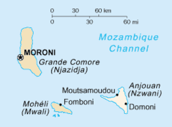
 Map of Anjouan.
Anjouan is part of the Comoros Islands located in the Mozambique Channel. The second most important (and the most populous) city on Anjouan is Domoni.[citation needed]
Climate
The highs on the island range from 27°C to 32°C (80°F to 90°F) year-round. The weather is warm and humid from December to April and slightly cooler from May to November.
Fauna
The Anjouan Scops Owl is a rare owl. The Anjouan Sparrowhawk is a possibly extinct subspecies of the Frances's Goshawk.
Culture
African mainlanders, Creoles, Arabs, Malay-Polynesians, Antalotes and Shirazis make up the population of Anjouan. The main religion is Sunni Islam. Although the island is filled with large numbers of mosques, religious observance is not as strict as it is in many other countries observing Islam. Alcohol is forbidden to Muslims.
Economy
The island uses the Comorian franc as a currency which is printed by the Bank of France and issued by the central bank of the country : the Central Bank of the Comoros. The economy of the island is dependent on agriculture and related industries. These industries employ over 80% of the work force. The island's main food staple is rice, most of which must be imported. Anjouan is the world's primary exporter of ylang-ylang oil, an ingredient in almost all perfumes.[10]
Banking system
Anjouan, pursuant to the Regulation of Banks and Comparable Establishments of 1999, licensed more than 300 offshore banks. All of the shell banks and other entities are located offshore and have no permanent presence in the Comoros. Anjouan sold the right to issue bank licenses and delegated most of its authority to operate and regulate the offshore business to private, non-Comoran domiciled parties.[11] In 2002, after Anjouan's reentry into the Union of the Comoros as an autonomous island, Anjouan's Offshore Finance Authority was established to promote the island as a tax haven to attract foreign capital.[10] In 2005, new laws were passed[12] and many of the banking licenses issued there were cancelled or carried over after additional fees were paid to the newly rearranged Offshore Finance Authority, monopolized by Anjouan Corporate Services Limited since 2003, which has claimed the authority as registered agent for all International Business Companies and banking license issuance on the island since that time. It should also be noted that the company claining to sell licenses previous to 2003 were sued in the London High Court and lost, The High Court of Justice confirmed after seeing all the legal documentation that Anjouan Corporate Services Ltd, were legally entitled to operate the offshore business.
The Central Bank of the Comoros claims sole authority to issue banking licenses (although they have no offshore legislation in place and are not equipped to handle any International Due Diligence) and the regulation of banks on any island in the Union.[11] How that would be legal, in light of the 2002 treaty under which Anjouan rejoined the Comoros Union as an autonomous island, is unclear. The United States Department of State and the Union government officials in Grande-Comore claim Anjouan no longer issue banking licenses to offshore entities, that current legal licensing authority rests with Union authorities, and the Anjouan counterparts are under Union control which undermines the 2002 treaty. However, the already established offshore entities remain outside Union control, and the entity to which the Anjouan authorities sold licensing authority may still be issuing licenses in the name of Anjouan. Further, they claim that offshore banks operating in the autonomous islands of the Union of the Comoros without prior authorization from the Union Finance Minister operate illegally, although they claim to have legally signed authority ( which the courts in London confirmed are legal ). Because the involved computer servers and illicit “entities” are located outside the Comoros, ( which applies in today's technical arena as normal practice )the Union government lacks the jurisdiction and capacity to act beyond the announcements and warnings regarding the illegal entities. The Comoran government has solicited the law enforcement authorities in France to locate the perpetrators, who were reportedly in Europe. During 2008, Comoros closed many of these "illegitimate" financial institutions.[11] What is interesting is that the Island of Moheli have been selling banking Licenses for the past 10 years under the email addresshttp://mwali-registrar.com/entities_banks.htm, with no problems from the Union authorities at all. They operate a web site with all their details, however there are no offshore authorities there at all.
Politics
Presidential elections were held in Anjouan on 15 June following the 2008 invasion of Anjouan to oust Mohamed Bacar as President of Anjouan.[13] About 128,000 people were eligible to vote.[14] Mohamed Djaanfari, a former vice-president of the Assembly of the Union of the Comoros, and Moussa Toybou, a former minister in Said Mohamed Djohar's government, advanced to the runoff round held on 29 June. The final official result, as confirmed by the constitutional court on 3 July 2008, declared Toybou the winner with 52.42% of the vote to Djaanfari's 47.58%.
Military
Anjouan invested heavily in its national security under Mohamed Bacar. Main components were the Gendarmerie commanded by Commander Abdou, the younger brother of Bacar. A battalion size militia of approximately 500 backed the Gendarmerie. Since the eviction of Bacar in March 2008, the Anjouanais defence forces are led by the Government of the Union of the Comoros.
The main strategic area is the airfield at Ouani with its 1.5 km runway and the bay with the coastal road from the capital Mutsamudu in the east out to the city of Sima in the west.
See also
- Postage stamps of Anjouan
References
- ^ Translation of the French name. The English-language page on the former Not official website (retrieved on 30 March 2008; Archived copy at Internet Archive) gives the name as "Government of Anjouan" or simply "Anjouan."
- ^ Site non officiel de l'île autonome d'Anjouan (Former Not official site of the Autonomous Island of Anjouan). Retrieved on 30 March 2008. Archived copy at Internet Archive. (French)
- ^ a b Anjouan.net — Official (English)
- ^ a b Constitution de l'État d’Anjouan. (Constitution of the State of Anjouan.) (French)
- ^ "COMOROS: Military invasion of Anjouan imminent, government warns". IRIN. 2008-01-31. http://www.irinnews.org/report.aspx?ReportId=76514. Retrieved 2008-03-25.
- ^ "Comoros anger over chopper crash". BBC News. BBC. http://news.bbc.co.uk/2/hi/africa/7306986.stm. Retrieved 2008-03-25.
- ^ "Comoros anger over chopper crash". BBC News. 2008-03-20. http://news.bbc.co.uk/2/hi/africa/7306986.stm.
- ^ "Comoran rebel asylum plea refused", BBC News (15 May 2008)
- ^ "Five candidates vie for the presidency of Anjouan." Afrique en ligne. 20 May 2008. Retrieved 5 June 2008.
- ^ a b Houlder V, Peel M. Harbours of resentment. Financial Times, December 1, 2008, p.11
- ^ a b c US State Department 2010 International Narcotics Control Strategy Report
- ^ Anjouan Corporate Services, August 30, 2006
- ^ AFP: Anjouan to elect new leader after rebel ousted
- ^ Angola Press
External links
- Official website of the Government of Comoros
- Anjouan.net (In English and French)
- Official website of the Central Bank of Comoros
- (http://anjouancorporateservices.com/legislation2.html)
- (http://anjouangov.com/content_eng/legislation.html)
French overseas empire Former Former French colonies in Africa and the Indian Ocean Maghreb - Algeria
- Morocco (Arguin Island)
- Tunisia
French West Africa French Equatorial Africa Comoros - Anjouan
- Grande Comore
- Mohéli
- French Somaliland (Djibouti)
- Madagascar
- Ile de France
- Seychelles
Former French colonies in the Americas Inini · Berbice · Saint-Domingue (Haiti) · Tobago · Virgin Islands · France Antarctique · Equinoctial FranceFormer French colonies in Asia and Oceania French India Indochinese Union French Mandate for Syria and the Lebanon Oceania Present  Overseas departments and territories of France
Inhabited areas 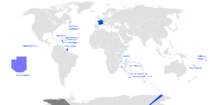 Special status
Uninhabited areas Pacific Ocean French Southern and
Antarctic LandsBanc du Geyser4 · Bassas da India4 · Europa Island4 · Glorioso Islands3, 4, 5 · Juan de Nova Island4 · Tromelin Island4, 51 Also known as overseas regions. 2 Claimed by Comoros. 3 Claimed by Madagascar. 4 Claimed by Seychelles. 5 Claimed by Mauritius.Categories:- Islands of Comoros
- History of Comoros
- Comoros archipelago
- Former countries in Africa
- Island countries
- Former colonies of France
- Former unrecognized countries
- States and territories established in 1997
- States and territories established in 2002
- Autonomous islands of the Comoros


Wikimedia Foundation. 2010.