- Île Saint-Paul
Infobox Country
native_name = "Île Saint-Paul"
conventional_long_name = St. Paul Island

symbol_type = Coat of arms
national_motto = "Liberté, égalité, fraternité "
national_anthem =La Marseillaise 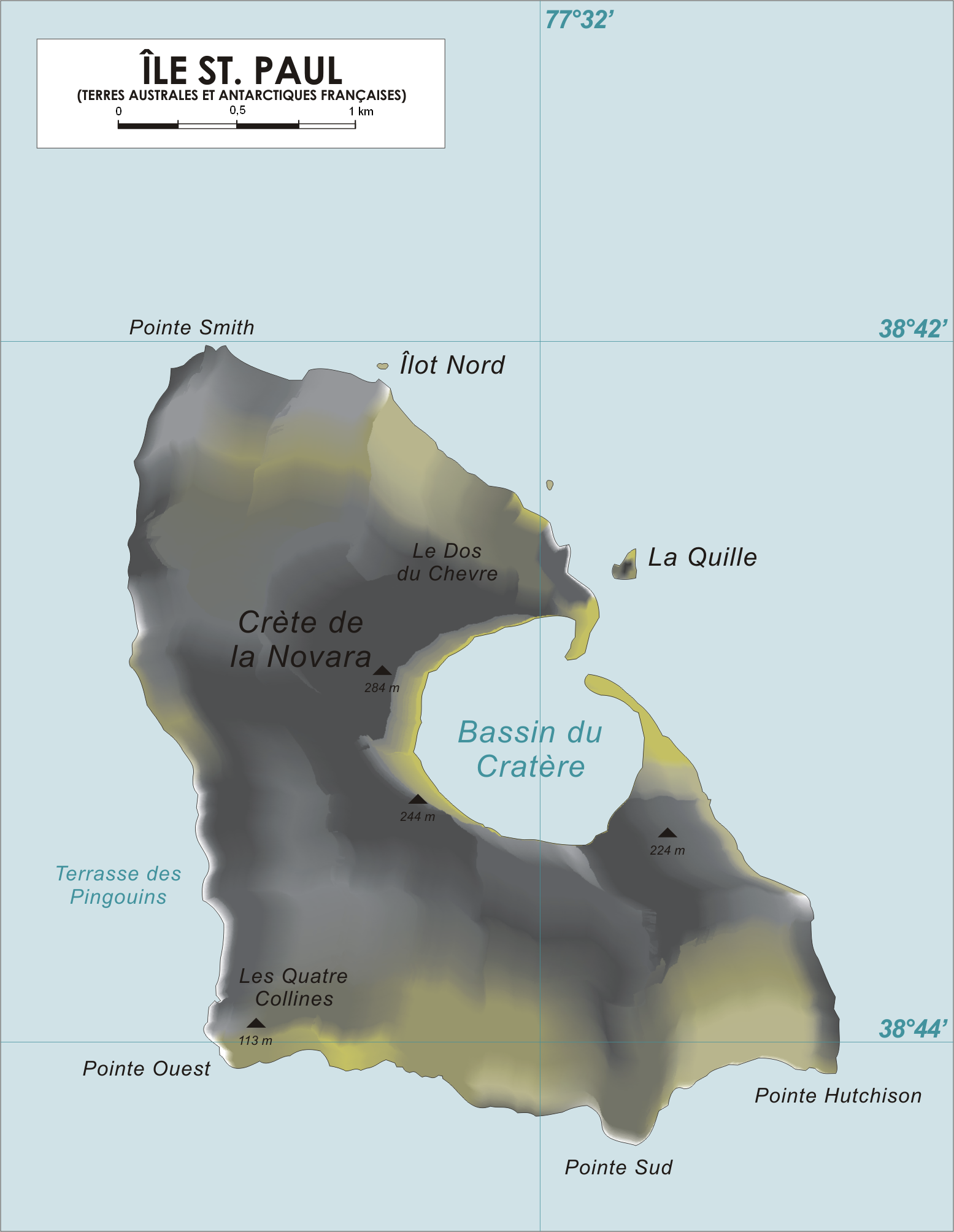
map_caption = Map of St. Paul IslandÎle Saint-Paul (St. Paul Island) is an
island forming part of theFrench Southern and Antarctic Lands in theIndian Ocean , with an area of 6 km² (2.3 sq mi). It is located about convert|85|km|abbr=on southwest of the largerÎle Amsterdam , and convert|3000|km|abbr=on south ofRéunion , at coord|38|43|19|S|77|31|44|E|. During sailing ship days captains would occasionally use the island as a check on their navigation before heading north. A scientific research cabin on the island is used for scientific or ecological short campaigns, but there is no permanent population.Along with Île Amsterdam, it is part of the district of the Overseas Territory of the Southern and Antarctic French Lands (
TAAF ), under the authority of a senior administrator onRéunion .Île Saint-Paul is one of three islands which is an antipode of the United States, corresponding to
Firstview, Colorado . The other two antipodes are Île Amsterdam andKerguelen Island .Description
Île Saint-Paul is triangular in shape, and measures no more than convert|3|mi|abbr=on at its widest. It is the top of an inactive volcano, and is rocky with steep cliffs on the east side. The thin stretch of rock that used to close off the crater collapsed in 1780, admitting the sea through a convert|100|m|abbr=on channel; the entrance is only a few meters deep, thus allowing only very small ships or boats to enter the crater itself. The interior basin, convert|1|km|abbr=on wide and convert|50|m|abbr=on deep, is surrounded by steep walls up to convert|270|m|abbr=on high. There are active
thermal spring s.History
Île Saint-Paul was first discovered in 1559 by Portuguese sailors and there were further sightings of the island through the 17th century. The first detailed description of it (and possibly the first landing) was by
William De Vlamingh in 1696. The first good map of the island was not drawn up until 1857, when the Austrian training ship "Novara" spent a fortnight sailing in front of it.In 1871 a British troop transport, HMS "Megaera", was wrecked on the island. Most of the 400 persons on board had to remain upwards of three months before being taken off.
In 1874 a French astronomical mission spent two months on the island observing the
transit of Venus ; geologistCharles Vélain took the opportunity to make a significant geological survey of the island.In 1889
Charles Lightoller , who was later to become famous as the Second Mate of the RMS "Titanic", was shipwrecked here for eight days when the sailingbarque "Holt Hill" ran aground. He describes the shipwreck and the island in his autobiography, "Titanic and Other Ships". Lightoller speculated that pirates may have used the island and their treasure could be buried in its caves. There is also speculation that officers from the German auxiliary cruiser "Atlantis" hid treasure near the entrance of the bay duringWorld War II . [Citation | first = C.H. | last = Lightoller | author-link = Charles Lightoller | title = Titanic and other ships | place = | publisher = I. Nicholson and Watson | url = http://gutenberg.net.au/ebooks03/0301011h.html | year = 1935 | doi = | isbn = ]Île Saint-Paul was claimed by France in 1893.
In 1928, an ill-fated
spiny lobster cannery was established on Île Saint-Paul. Seven employees of the cannery were abandoned to their fate on the island when the company went bankrupt in 1931; they later came to be known as "Les Oubliés de Saint-Paul" ("the forgotten ones of St. Paul"). Five died; the two survivors were finally rescued in 1934. [Les oubliés de lle Saint-Paul, by Daniel Floch. 1982.] ["St. Paul and Amsterdam Island: A History of Two Islands." Discoverfrance.com. [http://www.discoverfrance.net/Colonies/St-Paul_Amsterdam.shtml] ]See also
*
List of volcanoes in French Southern and Antarctic Lands
*Administrative divisions of France
*French overseas departments and territories
*Islands controlled by France in the Indian and Pacific oceans
*Sub-antarctic islands Notes
References
*
External links
*
* [http://www.farvoyager.com/siov/stpaul1.html Pictures of Île Saint-Paul]
* [http://www.weathergraphics.com/tim/antipode Antipodes of the USA]

Wikimedia Foundation. 2010.