- Tobago
-
For other uses, see Tobago (disambiguation).
Tobago 

Motto: Pulchrior Evenit (Latin)
"She becomes more beautiful"Anthem: Forged From The Love of Liberty 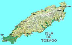
Capital Scarborough Official language(s) English, Tobago Creole Government autonomous island of Trinidad and Tobago - President of Trinidad and Tobago George Maxwell Richards - Prime Minister of Trinidad and Tobago Kamla Persad-Bissessar - Chief Secretary Orville London Area - Total 300 km2
116 sq miPopulation - 2000 estimate 54,000 Currency Trinidad and Tobago dollar ( TTD)Time zone (UTC-4) Internet TLD .tt Calling code 1-868 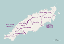 Parishes of Tobago
Tobago (
 /təˈbeɪɡoʊ/) is the smaller of the two main islands that make up the Republic of Trinidad and Tobago. It is located in the southern Caribbean, northeast of the island of Trinidad and southeast of Grenada. The island lies outside the hurricane belt. According to the earliest English-language source cited in the Oxford English Dictionary, Tobago bore a name that has become the English word tobacco.
Contents
Geography and climate
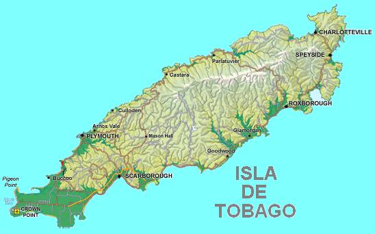
Tobago has a land area of 300 km² (116 mi²), and is approximately 42 km (26 mi) long and 10 km (6.2 mi) wide. It is located at latitude 11° 9' N, longitude 60° 40' W, slightly north of Trinidad. The population is 54,084 (2000). The capital is Scarborough which has a population of about 17,000. While Trinidad is multiethnic, the population of Tobago is primarily of African descent, although with a growing proportion of Trinidadians of East Indian descent and Europeans (predominantly Germans and Scandinavians). Between 1990 and 2000, the population of Tobago grew by 11.28 percent, making it one of the fastest growing areas of the country.
Tobago is primarily hilly and of volcanic origin.[1] The southwest of the island is flat and consists largely of coralline limestone. The hilly spine of the island, the Main Ridge. The highest point in Tobago is the 550 metre (1804 ft) Pigeon Peak near Speyside.[2]
Tobago is divided into seven parishes – three in the Western Region and four in the Eastern Region:
- Western Tobago:
- Saint Andrew
- Saint Patrick
- Saint David
- Eastern Tobago:
- Saint George
- Saint Mary
- Saint Paul
- Saint John
The climate is tropical, and the island lies just south of the Atlantic hurricane belt. Average rainfall varies between 3800 mm on the Main Ridge to less than 1250 mm in the south-west of the island. There are two seasons: a wet season between July and November, and a dry season between December and June.
History

 Man-of-War Bay
At the time of European contact, Tobago was inhabited by Island Caribs. The first European visitors appear to have been English in 1580. The first settlers were Courlanders in 1654. It changed hands 33 times[3] between Courland (vassal of the Polish-Lithuanian Commonwealth), Spain, England, France, Sweden, and the Dutch Republic until in 1814 it became part of the British Empire. In 1889 Tobago was united with Trinidad into a British crown colony. In 1962 they became an independent Commonwealth nation of Trinidad and Tobago, in 1976 a republic.[4]
Economy and tourism
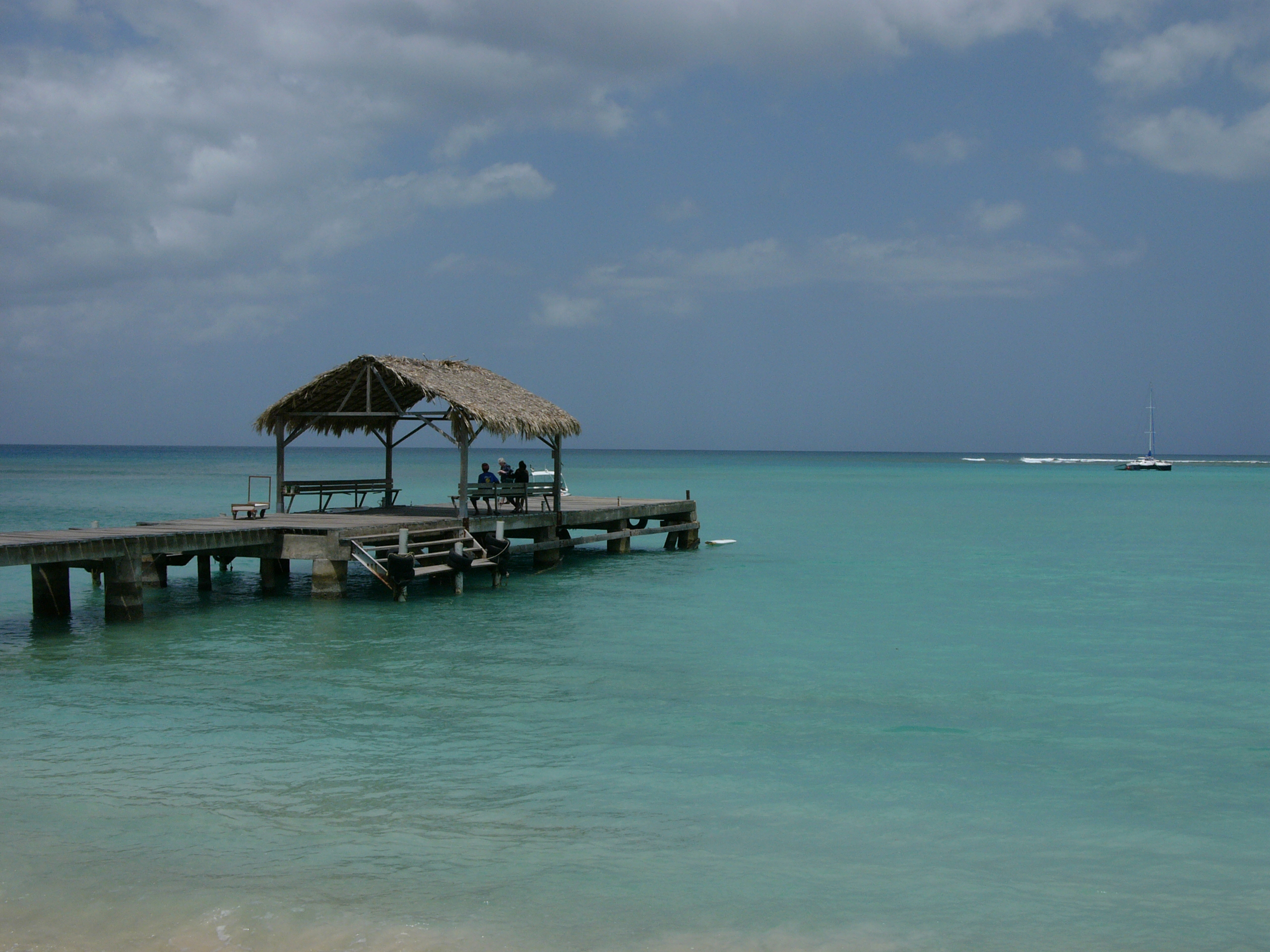
 Pigeon Point, Tobago
Tobago's economy is tightly linked with Trinidad, and is based on liquefied natural gas (LNG), petrochemicals, and steel. The principal economic forces specific to Tobago are tourism and government spending. Conventional beach and water-sports tourism is largely focussed in the south-west around the airport and the coastal strip; however, ecotourism is growing in significance, and much of it is focussed on the large area of protected forest in the centre and north of the main island and on Little Tobago, a small island off the north east tip of the main island.
Tourism is concentrated in the southwest of the island, around Crown Point, Store Bay, Pigeon Point and Buccoo Reef. This area has large expanses of sand and is dominated by resort type developments. Tobago has many idyllic beaches around its coastline, especially those at Castara, Bloody Bay, and Englishman's Bay.
Tobago is linked to the world through the Crown Point International Airport and the Scarborough harbour. Domestic flights connect Tobago with Trinidad, and international flights connect with the Caribbean and Europe. There is also a daily fast ferry service between Port of Spain and Scarborough.
 Beach in West coast of Tobago
The island of Tobago has been considered the island that the story Robinson Crusoe was written about.[5][6] However, the book is probably based on some of the experiences of Alexander Selkirk, who was marooned in the Pacific's Juan Fernández Islands. Adding to the confusion for modern claims of fame, this island was the filming location for the Walt Disney movie The Swiss Family Robinson.
Tobago is the site of the famous "mystery tombstone".[7]
Environmental problems
Coral reefs have been damaged recently by silt and mud runoff during construction of a road along the north east coast. There has also been damage to the reef in Charlotteville village caused by sealing the road at Flagstaff Hill and diverting more silty water down the stream from Flagstaff down to Charlotteville.
Diving
 Inside The 'Maverick Wreck'
Tobago is also a popular diving location, since it is the most southerly of the Caribbean islands which have coral communities. Trinidad, which is further south, has no significant coral because of low salinity and high silt content, the result of its position close to the mouth of Venezuela's Orinoco River. Scuba diving on Tobago tends to be centred at Speyside, almost diametrically across the island from the airport.
The island has some of the best diving sites in the Caribbean. There are three wrecks located around its shores, but the one usually considered the best is the Maverick Ferry, which used to travel between Trinidad and Tobago. The ferry is 350 feet long and has been sunk in 30 metres/100 feet just off Rocky Point, Mt. Irvine. The top of the wreck is at 15 metres/50 feet. The wreck has an abundance of marine life, including a 4-foot jewfish, a member of the grouper family. The wreck was purposely sunk for divers, and so all the doors and windows were removed.
The waters around the island are home to many species of tropical fish, rays, sharks, and turtles.
Ecology
The Tobago Forest Reserve (or the Main Ridge Reserve) claims to be the oldest protected forests in the Western world. It was designated as a protected Crown reserve on April 17, 1776 following representations by Soame Jenyns a Member of Parliament in Britain who had the responsibility for the development of Tobago. It has remained a protected area ever since.
This forested area has great biodiversity including many species of birds, mammals, frogs, (nonpoisonous) snakes, butterflies and other invertebrates. It is one of the most approachable areas of rainforest, since it is relatively small and there are government-appointed guides who provide an authoritative guiding service through the forest at a reasonable cost. The guides are knowledgeable about the plants and the animals, and can call down rare and exotic birds from the canopy by imitating their calls.
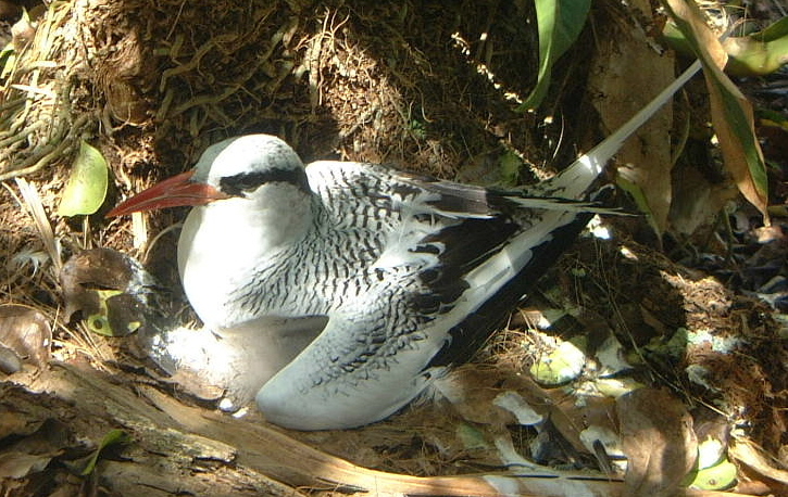
Little Tobago, the small neighbouring island, supports some of the best dry forest remaining in Tobago. Little Tobago and St. Giles Island are important seabird nesting colonies, with Red-billed Tropicbird, Magnificent Frigatebird and Audubon's Shearwater amongst others.
Government
Local Government functions in Tobago are handled by the Tobago House of Assembly. The current Chief Secretary of the THA is Orville London. The People's National Movement controls 8 seats in the Assembly, while the Tobago Organization of the People controls the 4 other seats.[8]
There are two parliamentary seats, Tobago East and Tobago West which are controlled by the TOP, winning them in the general elections in Trinidad and Tobago on May 24, 2010.
Tobago featured in the international press in early 2007 for its forward thinking in the creation of a Minister of Mental Health position. Minister Ellen Tang was appointed on the 1-year anniversary of the launch of the hugely successful Happiness Project. Her aide Melody Williams has been allocated a major proportion of the annual housing funding to revamp government housing projects all over the island.[citation needed]
Hurricanes
Although Tobago lies to the south of the hurricane belt, it was nevertheless struck by Hurricane Flora on September 30, 1963. The effects of the hurricane were so severe that they changed the face of Tobago's economy. The hurricane laid waste to the plantations of banana, coconut, and cacao, which largely sustained the economy. It wreaked considerable damage to the largely pristine tropical rainforest that makes up a large proportion of the interior of the northern half of the island. Subsequently, many of the plantations were abandoned, and the economy changed direction away from cash crop agriculture toward tourism. In 2004 Hurricane Ivan, although less severe than Flora, did cause significant damage.
References
- ^ "Tobago (Great Tobago) [1551"]. United Nations Earthwatch. http://islands.unep.ch/IWX.htm#Tobago. Retrieved 2011-10-19.
- ^ Anthony, Michael (2001). Historical Dictionary of Trinidad and Tobago. Scarecrow Press, Inc. Lanham, Maryland, and London. ISBN 0-8108-3173-2.
- ^ Tobago History
- ^ The New Trinidad & Tobago - from the original by Jos. A. De Suze (1846–1941), Collins, 1965. Reprint 1972, pp. 164-18.
- ^ Rhead, Louis. LETTER TO THE EDITOR: "Tobago Robinson Crusoe's Island", The New York Times, 5 August 1899.
- ^ "Robinson Crusoe and Tobago", Island Guide
- ^ Mystery Tombstone
- ^ Staff (2009-01-22). "TOP gains ground, but unhappy with illegal advertising". Trinidad and Tobago Guardian. http://guardian.co.tt/news/politics/2009/01/21/top-gains-ground-unhappy-illegal-advertising. Retrieved 2009-04-10.
External links
- Tobago Hotel & Tourism Association
- Tobago House of Assembly
- WorldStatesmen - Trinidad and Tobago
- Government of the Republic of Trinidad and Tobago
- National Library and Information System Authority of Trinidad and Tobago
- Parishes of Tobago (map)
Islands of Trinidad and Tobago Major Islands Trinidad • Tobago
Bocas Islands The Five Islands San Diego Islands Islands off Tobago Other Islands Categories:- Tobago
- Islands of Trinidad and Tobago
- Former British colonies
- Former Dutch colonies
- Former colonies of France
- Former colonies of Courland
- Western Tobago:


Wikimedia Foundation. 2010.