- Clipperton Island
-
Clipperton Native name: Île de la Passion 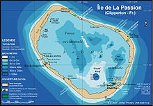
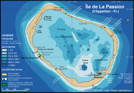
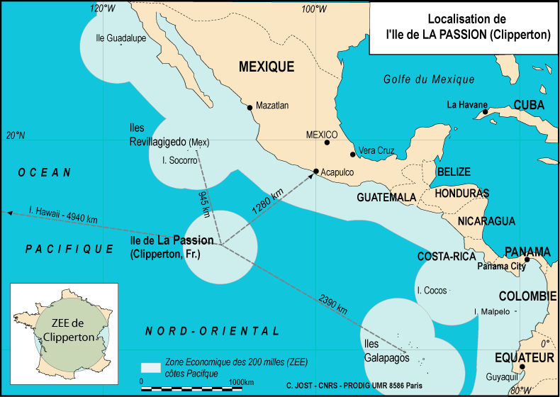
Clipperton Island with lagoon, showing depths in metres.Geography Location Pacific Ocean Coordinates 10°18′N 109°13′W / 10.3°N 109.217°W Archipelago None Area 6 km2 (2.3 sq mi) Highest elevation 29 m (95 ft) Highest point Clipperton Rock Country Possession of FranceDemographics Population Uninhabited Clipperton Island (French: Île de Clipperton or Île de la Passion, Spanish: Isla de la Pasión) is an uninhabited nine-square-kilometre (approx. 3.5-square-mile) coral atoll in the eastern Pacific Ocean, southwest of Mexico and west of Central America, at 10°18′N 109°13′W / 10.3°N 109.217°WCoordinates: 10°18′N 109°13′W / 10.3°N 109.217°W. It is an overseas possession of France under direct authority of the Minister of Overseas France.[1]
Clipperton Island is low-lying and largely barren, save for scattered grasses and a few clumps of coconut palms. A small volcanic outcrop rising to 29 metres (95 ft) on its southeast side is referred to as "Clipperton Rock".[2] The atoll has been occupied at various times by guano miners, would-be settlers or military personnel, mostly from Mexico, which formerly claimed it until international arbitration awarded it to France in 1931. However, Clipperton has had no permanent inhabitants since 1945. It is still visited on occasion by fishermen, French Navy patrols, scientific researchers, film crews, and shipwreck survivors. It has also proven a popular site for transmissions by ham radio operators.[3]
Contents
Natural conditions
Location, lagoon and climate
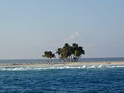 Coconut palms on Clipperton; the lagoon is visible past the trees
Clipperton Island lies about 945 km (587 mi; 510 nmi) southeast of Socorro Island in the Revillagigedo Archipelago, the nearest land. The ring-shaped atoll completely encloses a stagnant freshwater lagoon, and is 12 km in circumference (7.5 mi). The island's rim averages 150 metres (490 ft) in width, though it reaches 400 metres (1,300 ft) in the west and narrows to 45 metres (148 ft) in the northeast, where sea waves occasionally spill over into the lagoon. Land elevations average 2 metres (6.6 ft), though Clipperton Rock, a barren 29-metre (95 ft) volcanic outcrop located in the atoll's southeast, is considerably higher and forms the island's tallest point. The reef surrounding Clipperton is exposed at low tide.[4]
Clipperton's lagoon is devoid of fish, and contains some deep basins with depths of −43 and −22 metres (−141.1 and −72.2 ft), including a spot known as Trou-Sans-Fond, or "the bottomless hole", with acidic water at its base. The water is described as being almost fresh at the surface, and highly eutrophic. Seaweed beds cover approximately 45 percent of the lagoon's surface.[4]
While some sources have rated the lagoon water as non-potable,[5] testimony from the crew of the tuna clipper M/V Monarch, stranded on Clipperton for 23 days in 1962 after their boat sank, indicates otherwise. Their report reveals that the lagoon water, while not tasting very good, was drinkable, though "muddy and dirty". Several of the castaways drank it, with no apparent ill effects.[6] In contrast, however, survivors of the ill-fated Mexican military colony on Clipperton in 1917 (see below) indicated that they were dependent upon rain for their water supply, catching it in several old boats they used for this purpose.[7] Aside from the lagoon and water caught from rain, no other freshwater sources are known to exist on the island.
Clipperton Island has a tropical oceanic climate, with average temperatures of 20–32 °C (68–90 °F). The rainy season occurs from May to October, when it is subject to tropical storms and hurricanes. Surrounding ocean waters are warm, pushed by equatorial and counter-equatorial currents. The island has no known natural resources, its guano having been depleted early in the 20th century. Although 115 species of fish have been identified in the waters near Clipperton, the only economic activity in the area is tuna fishing.
Flora and fauna
When Snodgrass and Heller visited Clipperton in 1898, they reported that "no land plant is native to the island" (Snodgrass and Heller, 1902). Other historical accounts from 1711, 1825 and 1839, however, point out that the island had a low grassy or suffrutescent (partially woody) flora during those periods (Sachet, 1962). Coconut palms were introduced in the 1890s, and a few still survive. Introduction of pigs by guano miners at the beginning of the 20th century reduced the crab population on the island, which in turn allowed grassland to gradually cover about 80 percent of the land surface (Sachet, 1962). The elimination of these pigs in 1958 has caused most of this vegetation to disappear as millions of crabs (Gecarcinus planatus) have returned. The result is that Clipperton is now virtually a sandy desert, with only 674 remaining palms counted by C. Jost during the "Passion 2001" French mission, and five islets in the lagoon with grass that these terrestrial crabs cannot reach.
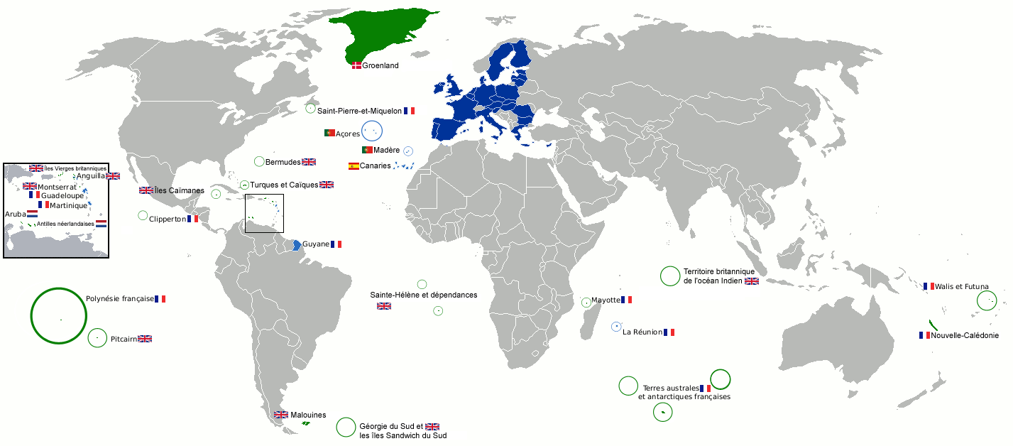
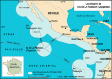 Location of Clipperton Island
During Sachet's visit in 1958, Clipperton's vegetation was found to consist of a sparse cover of spiny grass and low thickets, a creeping plant (Ipomoea sp.), and stands of coconut palm. This low-lying herbaceous flora seems to be pioneer in nature, and most of it is believed to be composed of recently introduced species. Sachet suspected that Heliotropium curassavicum and possibly Portulaca oleracea were native, however (Sachet 1962). On the northwest side of the island, the most abundant species are Cenchrus echinatus, Sida rhombifolia, and Corchorus aestuans. These plants compose a shrub cover up to 30 cm in height and are intermixed with Eclipta, Phyllanthus, and Solanum, as well as a taller plant, Brassica juncea. One interesting feature observed about Clipperton Island's flora is that the vegetation is arranged in parallel rows of species; dense rows of taller species alternate with lower, more open vegetation. This was assumed to be a result of the phosphate mining method of trench-digging.[4]
The only land animals known to exist on Clipperton Island are bright orange crabs (which are poisonous to consume), birds, lizards and rats, the last of which seem to have arrived from recently wrecked ships.[8] Bird species include White Terns, Masked Boobies, Sooty Terns, Brown Boobies, Brown Noddies, Black Noddies, Greater Frigates, Coots, Martins, Cuckoos and Yellow Warblers. Ducks have been reported in the lagoon.[4] The lagoon equally harbors millions of isopods, which swimmers claim can deliver a painful sting.[9]
A recent report (2006) by the NOAA's Southwest Fisheries Science Center in La Jolla, California, indicates that the increased rat presence on Clipperton Island has led to a decline in both crab and bird populations, causing a corresponding increase in both vegetation and coconut palms on the island. This report urgently recommended eradication of all the rats on the island, so that vegetation might be reduced and the island might return to its "pre-human" state.[8]
History
Discovery and early claims
Clipperton's name comes from John Clipperton, an English pirate and privateer who fought the Spanish during the early 18th century, and who is said to have passed by the island. Some sources say he used it as a base for his raids on shipping, yet there is no documentary evidence for this assertion.[10]
The name Île de la Passion (English: Passion Island) was officially given to Clipperton in 1711 by French discoverers Martin de Chassiron and Michel Du Bocage, commanding the French ships La Princesse and La Découverte. They drew up the first map of the island and annexed it to France. The first scientific expedition to Clipperton took place in 1725 under Frenchman M. Bocage, who lived on the island for several months. In 1858 France formally laid claim to Clipperton.
Other claimants included the United States, whose American Guano Mining Company claimed it under the Guano Islands Act of 1856; Mexico also claimed Clipperton due to activities undertaken there as early as 1848–1849. On November 17, 1858, Emperor Napoleon III annexed Clipperton as part of the French colony of Tahiti. However, this did not settle the question of Clipperton's ownership. On November 24, 1897, French naval authorities found three Americans on Clipperton working for the American Guano Company, who had raised the American flag on the island. However, U.S. authorities denounced their act, assuring the French that they did not intend to assert American sovereignty over Clipperton.[11]
Mexico reasserted its claim over Clipperton Island late in the 19th century, and on December 13, 1897, sent the gunboat La Democrata to occupy and annex it. A colony was established, and a series of military governors were posted to Clipperton from that time, the last of whom would be Ramón Arnaud (1906–1916). France insisted on its ownership of Clipperton, and a lengthy diplomatic correspondence between the two nations led to the conclusion of a treaty on March 2, 1909, to seek the arbitration of King Victor Emmanuel III of Italy, with each nation promising to abide by that monarch's final determination.[12] His decision would not be rendered until 1931.
Guano mining and the tragedy of 1917
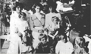 Survivors from Clipperton Island, 1917
The British Pacific Island Company acquired the rights to Clipperton's guano deposits in 1906, and built a mining settlement on the island in conjunction with the Mexican government. That same year, a lighthouse was erected under the orders of President Porfirio Díaz. By 1914, around 100 people—men, women, and children—were living on Clipperton Island, resupplied every two months by a ship from Acapulco. However, with the escalation of fighting in the Mexican Revolution, the regular resupply visits ceased, and the island's inhabitants were left to their own devices.[13] The US Navy warship Lexington visited the atoll in late 1915 and advised evacuation of all inhabitants, however the governor, Captain Arnaud, declared that evacuation was not necessary.[13]
By 1917, all but one of the males on Clipperton had died. Many had perished from scurvy, while others (including Captain Arnaud) died during a failed attempt to sail after a passing ship to fetch help. Lighthouse keeper Victoriano Álvarez ultimately found himself the last man remaining on the island, together with 15 women and children.[13] Álvarez proclaimed himself "king" and began an orgy of rape and murder, before being killed by Captain Arnaud's widow, who had become the recipient of his unwanted attentions.[13] Almost immediately after Álvarez's death, four women and seven children (the last survivors) were picked up by the US Navy gunship Yorktown on July 18, 1917.[13] Following this, no further attempts were made to permanently colonize Clipperton Island, though it would be briefly occupied during the 1930s and 40s.
The tragic tale of the Mexican colony on Clipperton Island has been the subject of several novels, including Ivo Mansmann's Clipperton, Schicksale auf einer vergessenen Insel ("Clipperton, Destinies on a Forgotten Island"); ISBN 3-354-00709-5 (in German, no English translation available).
Final arbitration of ownership
On January 28, 1931, King Victor Emanuel finally declared Clipperton to be a French possession.[14] The French rebuilt the island's lighthouse and settled a military outpost there, which remained for seven years before being abandoned.
Recent developments
Clipperton Island was abandoned by the end of World War II, after briefly being occupied by the USA (1944-5). Since then it has only been visited by sport fishermen, regularly scheduled patrols of the French Navy, and by Mexican tuna and shark fishermen. There have been infrequent scientific and amateur radio expeditions, and in 1978 Jacques-Yves Cousteau visited with his team of divers, plus a survivor from the 1917 evacuation, to film a television special called Clipperton: The Island that Time Forgot.[15]
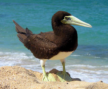 The Brown Booby
In 1958, Clipperton was visited by ornithologist Ken Stager of the Los Angeles County Museum. Appalled at the depredations visited by feral pigs upon the island's Brown Booby and Masked Booby colonies (reduced to 500 and 150 birds, respectively), Stager procured a shotgun and proceeded to hunt down and kill all of Clipperton Island's 58 pigs. By 2003, the Booby colonies on Clipperton boasted 25,000 Brown Boobies and 112,000 Masked Boobies, making the atoll the world's second-largest Brown Booby colony, and its largest Masked Booby colony.[8]
In 1962, the independence of Algeria threatened further French nuclear testing sites within that nation. The French Ministry of Defence considered Clipperton as a possible replacement location; however, due to the island's hostile climate and remote location, this was eventually ruled out. The French explored reopening the lagoon and developing a harbor for trade and tourism during the 1970s, but this idea, too, was ultimately abandoned. An automatic weather installation was completed on April 7, 1980, with data collected by this station being transmitted directly by satellite to Brittany.
In 1981, the Academy of Sciences for Overseas Territories recommended that the island have its own economic infrastructure, with an airstrip and a fishing port in the lagoon. This would mean opening up the lagoon by creating a passage in the atoll rim. For this purpose, an agreement was signed with the French government, represented by the High Commissioner for French Polynesia, whereby Clipperton became French state property. On October 13, 1986, a meeting took place regarding the establishment of a permanent base for fishing at Clipperton, between the high commissioner of French Polynesia, representing the state, and the survey firm for the development and exploitation of the island (SEDEIC). Taking into account the economic constraints, the distance from viable markets, and the small size of the atoll, nothing apart from preliminary studies was ever undertaken to carry out this project. Finally, all plans for development of Clipperton were abandoned.
Castaways
In early 1962 (as mentioned above), Clipperton provided a home to nine crewmen of the sunken tuna clipper M/V Monarch, who were stranded on the island for 23 days from February 6 to March 1 of that year. They reported that the lagoon water was drinkable, though they preferred to drink water from the coconuts they found. Unable to use any of the dilapidated buildings remaining on the island from previous occupants, they constructed a crude shelter from cement bags and tin salvaged from Quonset huts built by the American military twenty years earlier. Wood from the huts was used for firewood, and fish caught off the fringing reef combined with some potatoes and onions they had saved from their sinking vessel to augment the island's meager (as it turned out) supply of coconuts. The crewmen reported that they tried eating bird's eggs, but found them to be rancid, and they decided after trying to cook a "little black bird" that it did not have enough meat to make the effort worthwhile. Pigs that had previously inhabited Clipperton had been eradicated prior to this time, though the crewmen reported seeing their skeletons around the atoll. Eventually, these crewmen were discovered by another fishing boat, and were rescued by the United States Naval Destroyer USS Robison.[16]
In 1988, five Mexican fishermen became lost at sea after a storm that occurred during their trip along the coast of Costa Rica. They drifted within sight of Clipperton, but were unable to reach it.[17] In 1998, Steven Longbaugh and David Heritage, two American deckhands from a fishing boat based in California, were stranded on the island for three weeks. They were rescued after rebuilding a survival radio and using distress flares to signal for help.[18]
Recent history
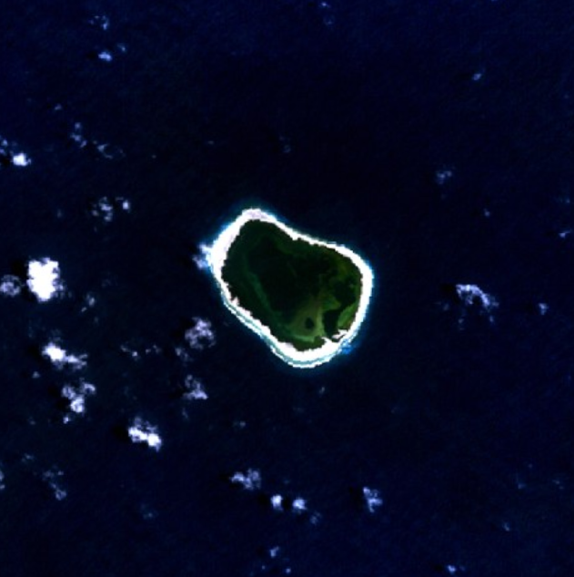
 Satellite image of Clipperton Island
The Mexican and French oceanographic expedition SURPACLIP (UNAM Mexico and UNC Nouméa) made extensive studies in 1997 on and around the island. In 2001, French geographer Ch. Jost extended the 1997 studies through his French "Passion 2001" expedition, explaining the evolution of the ecosystem, and releasing several papers, a video film, and a website.[19] In 2003 Lance Milbrand stayed on the island for 41 days on a National Geographic Society expedition, recording his adventure in video, photos, and a written diary (see links below).
In 2005, Clipperton's ecosystem was extensively studied for four months by a scientific mission organized by Jean-Louis Étienne, which made a complete inventory of mineral, plant, and animal species found on the atoll, studied algae as deep as 100 m (330 ft) below sea level, and examined the effects of pollution on the island. A 2008 expedition from the University of Washington's School of Oceanography collected sediment cores from the lagoon to study climate change over the last millennium.[20]
On February 21, 2007, the administration of Clipperton was transferred from the High Commissioner of the Republic in French Polynesia to the Minister of Overseas France.[21]
A recreational scuba diving expedition by the luxury liveaboard safari boat M/V Nautilus Explorer dove the reefs around Clipperton from April 15 to 20, 2007 to observe the marine life and compare these observations with those reported by the Connie Limbaugh (Scripps) expeditions in 1956 and 1958. Commencing in 2010, the Nautilus Explorer will be running diving expeditions from Cabo San Lucas to Clipperton Atoll via Socorro Island every spring.
During the night of February 10, 2010, the Sichem Osprey, a Maltese chemical tanker ran aground on Clipperton Island on its way from the Panama Canal to South Korea. The 170 meter-long (over 550 feet) ship contained Xylene, a clear, flammable liquid commonly used as a solvent in rubber, leather and the printing industries. All 19 crew members were reported safe, and the vessel reported no leaks of any kind.[22][23] The vessel was eventually re-floated on March 6[24] and is back in service.[25]
See also
Notes
- ^ Art. 9, Loi n° 55-1052 du 6 août 1955 modifiée portant statut des Terres australes et antarctiques françaises et de l'île de Clipperton.
Décret du 31 janvier 2008 relatif à l'administration de l'île de Clipperton. - ^ Clipperton Island History.
- ^ Clipperton Island DXpedition, includes details on several previous ham radio expeditions to Clipperton, and photos of the island.
- ^ a b c d Clipperton Island Shrubs and Grasslands
- ^ Clipperton Island Travel Tips, Lance Hildebrand's Journal
- ^ Atoll Research Bulletin No. 94. National Academy of Sciences, Washington, D.C., December 15, 1962, pp.8–9.
- ^ Atoll Research Bulletin No. 94. National Academy of Sciences, Washington, D.C., December 15, 1962, pg.10.
- ^ a b c Clipperton Island: Pig Sty, Rat Hole, and Booby Prize
- ^ 1992 Clipperton Island Expedition
- ^ Büch, Boudewijn. Eilanden ('Islands'). Holland, 1991, IScBN 9041330860
- ^ Clipperton Islands Case (Mexico v. France), Judicial Decisions Involving Questions of International Law (28 January 1931).
- ^ Original treaty between Mexico and France, French Foreign Ministry Archives, PDF file: Gouv-fr-PDF-19.
- ^ a b c d e History of Clipperton Island.
- ^ Clipperton Islands Case (Mexico v. France) Judicial Decisions Involving Questions of International Law (28 January 1931; article by William Heflin that includes a discussion of the case
- ^ Simon Rogerson, "Cousteau and the Pit", Dive magazine, July 19, 2006.
- ^ Atoll Research Bulletin No. 94. National Academy of Sciences, Washington, D.C., December 15, 1962, pp.8–10.
- ^ Arias, Ron. Five against the sea: A true story of courage and survival, 1989
- ^ LaJoie, John. ' 'American Maritime Accident Report' ', 1998
- ^ http://clipperton.fr
- ^ Clipperton Atoll Expedition 2008
- ^ http://www.worldstatesmen.org/Fr_minor.html
- ^ http://diver.net/bbs/posts002/81342.shtml Diver.Net, Retrieved, November 13, 2010.
- ^ http://reeftools.com/news/xylene-tanker-runs-aground-on-clipperton-island/ ReefTools, Retrieved November 13, 2010
- ^ http://www.lloydslist.com/ll/search-results.htm;jsessionid=4ABF68DBDE9D889B43BBE23A30C751CD Lloyds of London; Retrieved, November 13, 2010
- ^ http://www.marinetraffic.com/ais/shipdetails.aspx?MMSI=249534000 MarineTraffic.com Retrieved, November 13, 2010

This article is part of the series on
Administrative divisions of France(incl. overseas regions)
(incl. overseas departments)
Urban communities
Agglomeration communities
Commune communities
Syndicates of New AgglomerationOthers in Overseas FranceOverseas collectivities
Sui generis collectivity
Overseas country
Overseas territory
Clipperton IslandReferences
- Allen, G. R. and D. R. Robertson. 1996. An annotated checklist of the fishes of Clipperton Atoll, tropical eastern Pacific. Retrieved (2001) from: <http://www.ots.ac.cr/rbt/revistas/45-2/allen.htm>.
- Dickinson, Edwin D. The Clipperton Island Case. American Journal of International Law, Vol. 27, No. 1., pp. 130–133.
- IFRECOR. 1998. Clipperton. Retrieved (2001), PDF file: Reefbase-PDF-98.
- Jost, C. and S. Andrefouët, 2006, Review of long term natural and human perturbations and current status of Clipperton Atoll, a remote island of the Eastern Pacific, Pacific Conservation Biology, Surrey Beatty & Sons Pty Ltd, Chipping Norton, NSW, Australia, 12: 3
- Jost, C., 2005g, Risques environnementaux et enjeux à Clipperton (Pacifique français). Revue européenne Cybergeo, 314, 01 juillet 2005, cartes et fig., 15 p. http://193.55.107.45/eurogeo2.htm
- Jost, C., 2005f, Bibliographie de l'île de Clipperton, île de La Passion (1711–2005). Paris, Journal de la Société des Océanistes, 120–121, juin-déc. 2005, texte et 411 réf., pp. 181–197.
- Pitman, R. L. and J. R. Jehl, 1998. Geographic variation and reassessment of species limits in the "masked" boobies of the eastern Pacific Ocean. Wilson Bulletin 110:155–170.
- Restrepo, Laura. La Isla de la Pasión (a version of the tragic events which took place on Clipperton, put in the form of a novel).
- Sachet, M. H. 1962. Flora and vegetation of Clipperton Island. Proceedings of the California Academy of Sciences. 4th ser., v.31, no.10. The Academy, San Francisco.
- Skaggs, Jimmy. 1989. Clipperton. A History of the Island the World Forgot. Walker and Company. New York.
- Snodgrass, R. E. and E. Heller. 1902. The birds of Clipperton and Cocos Islands; Papers from the Hopkins Stanford Galapagos expedition 1898–1899. The Academy, Washington, DC.
- Tamburini Francesco, La controversia tra Francia e Messico sulla sovranità dell'isola di Clipperton e l'arbitrato di Vittorio Emanuele III (1909–1931), in "Ricordo di Alberto Aquarone, Studi di Storia", Pisa, Edizioni Plus, 2008
- UNEP/IUCN. 1988. Coral Reefs of the World. Volume 3: Central and Western Pacific. UNEP Regional Seas Directories and Bibliographies. IUCN/UNEP, Gland, Switzerland, Cambridge, UK, and Nairobi, Kenya.
External links
Photo galleries
- Clipperton Island 2008 Flickr gallery containing 94 large photos from a visit to Clipperton Island in 2008.
- 3D Photos of Clipperton Island 2010 3D anaglyphs of Clipperton Island
General sites
- Wikimedia Atlas of Clipperton Island
- Clipperton Island travel guide from Wikitravel
- Clipperton Island at Infoplease
- WorldStatesmen – France – Minor possessions
French-language sites
- (French) 80 pages from C. Jost, CNRS, researcher's site
- (French) Site of Jean-Louis Étienne's expedition
Expeditions to Clipperton
- Lance Milbrand's castaway photo album at NationalGeographic.com
- Lance Milbrand's Clipperton diary at NationalGeographic.com
- 1992 Clipperton Island Expedition
- Chris Grossman's pictures from the 2007 Nautilus Explorer expedition to Clipperton Island
- The 2008 Amateur Radio "DXpedition"
- "Cousteau and the Pit", Simon Rogerson, Dive magazine, July 19, 2006.
- 2008 Clipperton Atoll Expedition, includes several large photos of Clipperton Atoll.
List of North America-related topics Sovereign states Antigua and Barbuda · Bahamas · Barbados · Belize · Canada · Costa Rica · Cuba · Dominica · Dominican Republic · El Salvador · Grenada · Guatemala · Haiti · Honduras · Jamaica · Mexico · Nicaragua · Panama · Saint Kitts and Nevis · Saint Lucia · Saint Vincent and the Grenadines · Trinidad and Tobago · United States
Dependencies and
other territoriesAnguilla · Aruba · Bermuda · Bonaire · British Virgin Islands · Cayman Islands · Curaçao · Greenland · Guadeloupe · Martinique · Montserrat · Navassa Island · Puerto Rico · Saint Barthélemy · Saint Martin · Saint Pierre and Miquelon · Saba · Sint Eustatius · Sint Maarten · Turks and Caicos Islands · United States Virgin Islands
 Overseas departments and territories of France
Inhabited areas 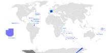 Special status
Uninhabited areas Pacific Ocean Clipperton IslandFrench Southern and
Antarctic LandsBanc du Geyser4 · Bassas da India4 · Europa Island4 · Glorioso Islands3, 4, 5 · Juan de Nova Island4 · Tromelin Island4, 51 Also known as overseas regions. 2 Claimed by Comoros. 3 Claimed by Madagascar. 4 Claimed by Seychelles. 5 Claimed by Mauritius. Categories:- Clipperton Island
- Overseas departments, collectivities and territories of France
- Tropical and subtropical grasslands, savannas, and shrublands
- States and territories established in 1931
- Islands claimed under the Guano Islands Act
- Former populated places in North America
- Former populated places in Oceania
- Territorial disputes of France
- Territorial disputes of Mexico
- Arbitration cases
- Uninhabited islands of France
- Uninhabited islands of the Pacific Ocean
- Dependent territories in North America
- ^ Art. 9, Loi n° 55-1052 du 6 août 1955 modifiée portant statut des Terres australes et antarctiques françaises et de l'île de Clipperton.


Wikimedia Foundation. 2010.