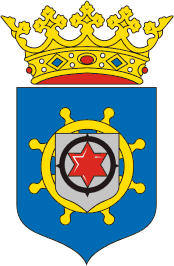
- Bonaire
Infobox_Country
native_name = "Eilandgebied Bonaire Teritorio Insular di Boneiru"
conventional_long_name = Island Territory of Bonaire
common_name = Bonaire
 |90px
|90px 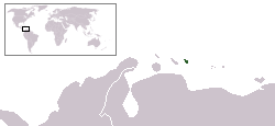
national_anthem = "Tera di Solo y suave biento "
official_languages = Dutch,Papiamentu
unofficial_languages =English andSpanish
government_type = "SeePolitics of the Netherlands Antilles "
leader_title1 = Administrator of Bonaire
leader_name1 =Herbert Domacassé
leader_title2 = Governor of N.A.
leader_name2 =Frits Goedgedrag
sovereignty_type =Constitutional monarchy
sovereignty_note = part of theNetherlands Antilles
capital =Kralendijk
largest_city = Kralendijk
area_magnitude = 1_E12
area_km2=294
area_sq_mi = 113 | population_census = 14,006
population_census_year = 2006
population_density_km2 = 49
population_density_sq_mi = 99
population_density_rank = ranked as part of N. A.
utc_offset = -4
time_zone = -4
latd=12|latm=15|latNS=N|longd=68|longm=28|longEW=W
currency =Netherlands Antillean guilder
currency_code = ANG
cctld = .an
calling_code = 599The Island Territory of Bonaire (Dutch: "Eilandgebied Bonaire",
Papiamento : "Teritorio Insular di Boneiru") is one of five island areas ("Eilandgebieden") of theNetherlands Antilles , consisting of the main island of Bonaire and, nestled in its western crescent, the uninhabited islet ofKlein Bonaire . Together withAruba andCuraçao it forms a group referred to as the ABC islands of theLeeward Antilles , the southern island chain of theLesser Antilles .As part of the Netherlands Antilles, Bonaire is accordingly a part of the
Kingdom of the Netherlands . The structure of the relationship between Bonaire, the Netherlands Antilles and the Kingdom is being considered for change under proposed legislation. This restructuring is still planned, but has been postponed to an indefinite future date. [ [http://www.thedailyherald.com/news/daily/k006/steer006.html St. Maarten-St. Martin - Consensus, but no date set for new status ] ]History
Original Inhabitants
Bonaire's first inhabitants were the
Caquetios Indian s, a branch of theArawak who, around 1000 AD, sailed from what is now Venezuela. Traces of Caquetio culture are at a number of archaeological sites, including those at Lac Bay and northeast of Kralendijk. Rock paintings andpetroglyph s have survived at the caves at Spelonk, Onima, Ceru Pungi, and Ceru Crita-Cabai. The Caquetios were apparently a very tall people, for the Spanish dubbed the Leeward Islands 'las Islas de los Gigantes' (the islands of the giants).fact|date=February 2008Control
Bonaire was claimed for the Spanish by
Amerigo Vespucci andAlonso de Ojeda in 1499. Under Spanish occupation, the natives were enslaved and transported to Hispaniola, but the island's physical resources were largely ignored. By 1526, the island was depopulated. That year, Juan de Ampues, regional governor, turned it into a cattle plantation and repopulated it with Indians.In 1633, the Dutch, having lost the island of St. Maarten to the Spanish, retaliated by capturing Curaçao, Bonaire, and Aruba. While Curaçao emerged as a center of the slave trade, Bonaire became a plantation of the Dutch West India Company. A small number of African slaves were put to work alongside Indians and convicts, cultivating dyewood and maize and harvesting solar salt around Blue Pan. Slave quarters, rising no higher than a man's waist and built entirely of stone, still stand in the area around Rincon and along the saltpans as a grim reminder of Bonaire's repressive past.
The Netherlands lost control of the island twice, from 1800-1803 and 1807-1815. During these intervals, the British had control over the neighboring island of
Curaçao , and, by extension, Bonaire. During the German occupation of the Netherlands duringWorld War II , Bonaire was a protectorate of Britain and the United States.Tourism
Bonaire's economy is mainly based on tourism. The island caters, almost exclusively, to scuba divers and snorkelers. Wind surfers also constitute a strong group of island tourists. Tourism infrastructure is Bonaire is contemporary and based on time-share resorts. There are a few small B&Bs. Most resorts have an on-site dive shop. The rest are affiliated with a dive operation.
Geography
Bonaire has a land area of 288 km² (111 sq. miles), while Klein Bonaire is a further 6 km² (2.3 sq. miles). Bonaire's Afdeling Bevolking (census) office reported that the population of was 14,006 inhabitants as of December, 2006, [ Bonaire Reporter
February 9 2007 ] which gives Bonaire island proper a population density of 49 inh. per km².Bonaire lies outside the
hurricane belt , and is served byFlamingo International Airport .Bonaire is world renowned for its excellent
scuba diving and is consistently rated among the best diving andCaribbean diving locations in the world. Bonaire's license plates carry the logo "Diver's Paradise" (in English). The island is ringed by a coral reef which is easily accessible from the shore along the Western and Southern sides. Furthermore, the entire coastline of the island has been declared amarine sanctuary , preserving local fish life. Bonaire is also consistently recognised as one of the best destinations forsnorkeling .The
coral reef around uninhabitedKlein Bonaire is particularly well conserved, and it draws divers, snorkelers, and boaters.Bonaire also has several
coral reefs where seahorses are common.Bonaire is also famed for its
flamingo populations and itsdonkey sanctuary. Flamingos are drawn to the brackish water, which harbours shrimp they feed on. Starting in the 1500s, the Dutch raisedsheep ,goats ,pigs ,horses and donkeys on Bonaire, and the descendants of the goats and donkeys roam the island today.Washington Slagbaai National Park, located at the north side of the island, is an ecological preserve. The highest point of Bonaire, Brandaris, located within this preserve has a complete view of the island.
Lac Bay, (also known as Lac Cai or Lac Cay) on the eastern side of the island, is a windsurfer's paradise. Locals Taty and Tonky Frans in 2004 were ranked in the top five of the world's freestyle windsurfing professionals.
Finally, Atlantis Beach, on the western part of the island, is the local
kitesurfing spot.Cities/Towns
The only generally recognized towns on the island are
Kralendijk and Rincon.Kralendijk has many suburbs/neighbourhoods (on an island with such a small population, the distinction is not always clearcut). Kralendijk's suburbs/neighbourhoods include:
*Antriol
*Belnem
*Hato
*Lima
*Noord Salina
*Nikiboko
*Republiek
*Sabadeco
*Sabana
*Santa Barbara
*Tera CoraOther smaller settlements include
*Fontein
*Lagoen
*Sorobon
*Spelonk
*WanapaSeveral smaller towns had existed in the national park, but are now abandoned. They were: Labra, Ishiri, Kokorobi, Jan Doran, Vlijt, Rigot, Porto Spano, and Kunchi.
Languages
The official languages are Dutch,
Papiamentu , and English. English became an official language of the Netherlands Antilles in March, 2007. In practice, it is not used for official purposes on Bonaire. Spanish and English are widely spoken on the island.ee also
*
Schunck's Kledingindustrie Bonaire Gallery
References
External links
Government:
* [http://www.gov.an/ www.gov.an] - official governmental portal of the Netherlands Antilles
* [http://www.bonaire-gov.an/ Bonaire-gov.an] - official website of the government of Bonaire
* [http://www.bonaireeconomy.org/ BonaireEconomy.org] - Department of Economic & Labour Affairs (DEZA)Island Information:
*wikitravel
* [http://www.tourismbonaire.com/ TourismBonaire.com] - The Official Bonaire Tourism Site
* [http://www.ilovebonaire.com/ BONHATA - Bonaire Hotel and Tourism Association]
* [http://www.infobonaire.com/ InfoBonaire.com] - The Bonaire Information Site
* [http://www.lonelyplanet.com/destinations/caribbean/bonaire/index.htm Lonely Planet - Bonaire]
* [http://www.bonairetalk.com/cgi-local/bbs/discus.cgi?pg=topics BonaireTalk.com] - Active Bonaire discussion board
* [http://www.bonbinibonaire.nl/ Bon Bini Bonaire] Nature:
* [http://www.bmp.org/ Bonaire National Marine Park]
* [http://www.bonairenature.com/ Bonaire Nature]
* [http://www.washingtonparkbonaire.org/ Washington Slagbaai National Park] News:* [http://www.bonairereporter.com/ Bonaire Reporter] - English language weekly newssheet about Bonaire
* [http://www.bonaireinsider.com/ Bonaire Insider] - Current Bonaire tourism news
* [http://www.extrabon.com/ Extra Bonaire] - Papiamentu language daily newspaper about Bonaire
* [http://www.bonaire-update.com/ Bonaire Update] - Bonaire activity information, updated bi-weekly
* [http://www.nosfm.com/ NosFM.com] - Radio stations in Bonaire's language; PapiamentoWebCams:
* [http://www.breathebonaire.com/ Breathe Bonaire] - Live webcams from Bonaire (including the first megapixel underwater webcam)
* [http://www.bonairewebcams.com/ BonaireWebCams.com] - Live webcams from the island of Bonaire (including the Bonaire ReefCam)Other Photos of Bonaire
* [http://www.chadmassaker.com/Lists/Photos/Forms/AllItems.aspx?RootFolder=%2FLists%2FPhotos%2FBonaire%20Dive%20Trip&View={B0973EBC-9DEC-4862-B601-B9E82510FE6E} Over 1100 Photos of the Island Above & Below Water]
Wikimedia Foundation. 2010.