- Nazareth Bank
-

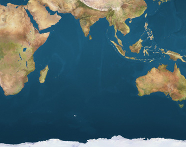
 Nazareth BankLocation of the Nazareth Bank in the Indian Ocean
Nazareth Bank is a large submerged bank in the Indian Ocean. It lies about 1040 km east of northern Madagascar and 280 km south of Saya de Malha Bank. The closest land is Cargados Carajos shoals, a small and remote dependency of Mauritius located 140 km to the southwest. The Nazareth Bank is part of the vast undersea Mascarene Plateau[1] and of the Reunion hotspot track.[2] The center of the bank is at 14°30′0.0″S 60°40′0.00″E / 14.5°S 60.66667°E. Its extent is about 176 km north-south and up to 87 km east-west, with a surface of about 11,000 km²[3]. This undersea bank is administered by Mauritius.
See also
References
- ^ Mascarene Plateau, Western Indian Ocean
- ^ Geochronology of Basement Rocks from the Mascarene Plateau, the Chagos Bank and the Maldives Ridge
- ^ Sources cite area figures between 7,625 and 26,000 km²
External links
Fishing industry by region By country 
Fishing banks By species Other areas Fisheries and fishing topic areas Fisheries 
Fishing - Fisherman
- Artisan fishing
- Fishing villages
- Fishing vessels
- Fishing history
Industrial Recreational Techniques Tackle Locations - Fishing by country
- Fishing villages
- Fishing banks
- Fish ponds
- Marine habitats
- Index of fishing articles
- List of fishing topics by subject
- Fisheries glossary
 Mauritius topics
Districts Black River · Flacq · Grand Port · Moka · Pamplemousses · Plaines Wilhems · Port Louis · Rivière du Rempart · Savanne
Dependencies and
territoriesAgalega Islands · Cargados Carajos Shoals (St. Brandon) · Rodrigues · Soudan Banks · Nazareth Bank · Saya de Malha Bank · Hawkins BankTerritorial claims Politics and
governmentEconomy People Religion Culture Other topics Categories:- Reefs of the Indian Ocean
- Landforms of Mauritius
- Fishing banks
- Fishing areas of the Indian Ocean
- Marine geography stubs
- Mauritius geography stubs


Wikimedia Foundation. 2010.