- Chagos Archipelago
-
The Chagos Archipelago (
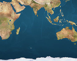
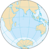
 /ˈtʃɑːɡoʊs/ or /ˈtʃɑːɡəs/; formerly Oil Islands, known as Foalhavahi ފޯޅަވަހި in Dhivehi, as Phehandweep फेहंद्वीप in Hindi and other North Indian languages, and as Paeikaana Theevukal பேகான தீவுகள் in Tamil) is a group of seven atolls comprising more than 60 individual tropical islands in the Indian Ocean; situated some 500 kilometres (310 mi) due south of the Maldives archipelago. This chain of islands are the Southernmost archipelago among the Lakshadweep-Maldives-Chagos group of islands, which are in reality the tops of a vast undersea submarine mountain range, in the Indian Ocean and the Arabian Sea.[1] The islands and their surrounding waters, form a vast oceanic Environment Preservation and Protection Zone (EPPZ) (Fisheries Conservation and Management Zone (FCMZ) of 544,000 square kilometres (210,000 sq mi)), an area twice the size of the UK's land surface.
Officially part of the British Indian Ocean Territory, the Chagos were home to the Chagossians for more than a century and a half until the United Kingdom evicted them in the early 1970s in order to allow the United States to build a military base on Diego Garcia, the largest of the Chagos Islands. Since 1971, only the atoll of Diego Garcia is inhabited, and only by military and civilian contracted personnel.
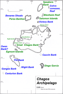
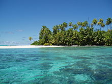
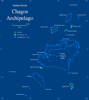
The Chagos group is a combination of different coralline structures topping a submarine ridge running southwards across the centre of the Indian Ocean, formed by volcanoes above the Réunion hotspot. Unlike in the Maldives there is not a clearly discernible pattern of arrayed atolls, which makes the whole archipelago look somewhat chaotic. Most of the coralline structures of the Chagos are submerged reefs.
The Chagos contain the world’s largest coral atoll (The Great Chagos Bank). It also has one of the healthiest reef systems in the cleanest waters in the world, supporting half the total area of good quality reefs in the Indian Ocean. As a result, the ecosystems of the Chagos have so far proven resilient to climate change and environmental disruptions.
The British government's Cabinet recently established the The Chagos Archipelago as the world's largest marine reserve, larger than the country of France or the state of California. The protection of the marine reserve will be guaranteed for the next five years thanks to the financement of the Bertarelli Foundation.[2] On December 3, 2010, Wikileaks released a document revealing that the marine reserve was established primarily in order to legally block any attempts by the Chagossians to return to their homeland.[3]
Contents
Biology
The biodiversity of the Chagos archipelago and its surrounding waters is one of the main reasons it is so special. But this incredible diversity is under threat as at least 60 species that call Chagos home are already on the IUCN Red List of Threatened Species.[citation needed]
Coral
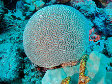
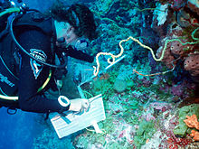
The reefs host 220 species of coral including the endemic brain coral Ctenella chagius. The coral cover is dense and healthy even in deep water on the steep outer reef slopes. Thick stands of branching staghorn coral (Acropora sp) protect the low lying islands from wave erosion. Despite the loss of much of the coral in a bleaching event in 1998 the recovery in the Chagos has been remarkable and overall coral cover increases year on year.
Fish
The reefs are also home to at least 784 species of fish that stay near to the shores of the islands including the endemic Chagos clownfish (Amphiprion chagosensis) and many of the larger wrasse and grouper that have already been lost from over-fishing in other reefs in the region.
As well as the healthy communities of reef fish there are significant populations of pelagic fish such as manta rays (Manta birostris), sharks and tuna. Shark numbers have dramatically declined as a result of illegal fishing boats that seek to remove their fins and also as accidental by-catch in the two tuna fisheries that operate seasonally in the Chagos.
Birds
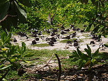
Seventeen species of breeding seabirds can be found nesting in huge colonies on many of the islands in the archipelago, and 10 of the islands have received formal designation as Important Bird Areas, by Birdlife International. This means that Chagos has the most diverse breeding seabird community within this tropical region. Of particular interest are the large colonies of sooty terns (Sterna fuscata), brown and lesser noddies (Anous stolidus and Anous tenuirostris) wedge-tailed shearwaters (Puffinus pacificus) and red-footed boobies (Sula sula).
Turtles
The remote islands make perfect undisturbed nursery sites for nests of green (Chelonia mydas) and hawksbill (Eretmochelys imbricata) turtles. The populations of both species in Chagos are of global significance given the "Critically Endangered" status of hawksbills and the "Endangered" status of green turtles on the IUCN Red List. Chagos turtles were heavily exploited during the previous two centuries, but they and their habitats are now well protected by the administration of the British Indian Ocean Territory and are recovering well.
Crabs
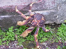 Coconut crabs are the world's largest terrestrial arthropod and live in one of the most undisturbed populations in the Chagos
The coconut crab (Birgus latro) is the world’s largest terrestrial arthropod, reaching over one metre in leg span and 3.5-4 kilos in weight. As a juvenile it behaves like a hermit crab and uses empty coconut shells as protection but as an adult this giant crab climbs trees and can crack through a coconut with its massive claws. Despite its wide global distribution, it is rare in most of the areas it is found. It is primarily threatened by over-collection for food, but also as ornaments for sale to tourists and as bait for fish traps. Demand for coconut crabs as souvenirs is strong, and other threats include habitat destruction and predation from introduced species such as rats. The coconut crabs on Chagos constitute one of the most undisturbed populations in the world. An important part of their biology is the long distances their young can travel as larvae. This means the Chagos coconut crabs are a vital source for replenishing other over-exploited populations in the Indian Ocean region.
Insects
Main article: List of Lepidoptera of the Chagos ArchipelagoA total of 113 species of insect have been recorded from the Chagos Islands.
Plants
The Chagos Islands have been colonised by plants since there was sufficient soil to support them – probably less than 4,000 years. Seeds and spores arrived on the emerging islands by wind and sea, or from passing sea birds. The native flora of the Chagos Islands is thought to comprise forty-one species of flowering plants and four ferns as well as a wide variety of mosses, liverworts, fungi and cyanobacteria.
Today, the status of the Chagos Islands’ native flora depends very much on past exploitation of particular islands. About 280 species of flowering plants and ferns have now been recorded on the islands, but this increase reflects the introduction of non-native plants by humans, either accidentally or deliberately. Because some of these non-native species have become invasive and pose a threat to the native ecosystems, plans are being developed to control them. On some islands, native forests were felled to plant coconut palms for the production of copra oil. Other islands remain unspoiled and support a wide range of habitats, including unique Pisonia forests and large clumps of the gigantic fish poison tree (Barringtonia asiatica). Unspoiled islands provide us with the biological information that we need in order to re-establish the native plant communities on heavily altered islands. These efforts will ultimately help to improve the biodiversity of the Chagos Islands.
Geography
The entire land area of the islands is a mere 63.17 km², with the largest island, Diego Garcia, having an area of 27.20 km². The total area, including lagoons within atolls, however, is more than 15,000 km², of which 12,642 km² are accounted by the Great Chagos Bank, the second largest atoll structure of the world (after the completely submerged Saya de Malha Bank). The shelf area is 20,607 km², and the Exclusive Economic Zone, which borders the corresponding zone of the Maldive Islands in the north, has an area of 636,600 km² (including territorial waters).
The largest individual islands are Diego García (27.20 km²), Eagle (Great Chagos Bank, 2.45 km²), Île Pierre (Peros Banhos, 1.50 km²), Eastern Egmont (Egmont Islands, 1.50 km²), Île du Coin (Peros Banhos, 1.28 km²) and Île Boddam (Salomon Islands, 1.08 km²).
The number of atolls in the Chagos Islands is given as four or five in most sources, plus two island groups and two single islands, mainly because it is not recognized that the Great Chagos Bank is a huge atoll structure (including those two island groups and two single islands), and because it is not recognisd that Blenheim Reef has islets or cays above or just reaching the high water mark.
In addition to the seven atolls with dry land reaching at least the high water mark, there are nine reefs and banks, most of which can be considered permanently submerged atoll structures. They are listed in the table from north to south:
The deep oceanic waters around the Chagos Islands, out to the 200 nautical mile limit, include an exceptional diversity of undersea geological features (such as 6000m deep trenches, oceanic ridges, and sea mounts). These areas almost certainly harbour many undiscovered and specially adapted species. Although the deepwater habitats surrounding the islands have not been explored or mapped in any detail, work elsewhere in the world has shown that high physical diversity of the sea floor is closely linked to a high diversity of species.
Resources
The main natural resources of the area are coconuts, and fish and the licensing of commercial fishing provides an annual income of about two million dollars for the British Indian Ocean Territory authorities.[4]
All economic activity is concentrated on the largest island of Diego Garcia, where joint UK-US military facilities are located. Construction projects and various services needed to support the military installations are done by military and contract employees from the UK, Mauritius, the Philippines, and the US. There are currently no industrial or agricultural activities on the islands. All the water, food and other essentials of daily life are shipped to the island. An independent feasibility study led to the conclusion that resettlement would be "costly and precarious". Another feasibility study, commissioned by organisations supporting resettlement, found that resettlement would be possible at a cost to the British taxpayer of £25 million. If the Chagossians return, they plan to re-establish copra production and fishing, and to begin the commercial development of the islands for tourism.
Skipjack (Euthynnus pelamis) and yellowfin tuna (Thunnus albacares) are fished for about two months of the year as their year-long migratory route takes them through Chagos waters. While the remoteness of the Chagos offers some protection from extractive activities, legal and illegal fishing have had an impact. There is considerable poaching of turtles and other marine life. Sharks, which play a vital role in balancing the food web of tropical reefs, have suffered sharp declines from illegal fishing for their fins and as bycatch in legal fisheries. Sea cucumbers, which cleanse sand, are poached to feed Asian markets.
Climate
The Chagos Archipelago has a Tropical oceanic climate; hot and humid but moderated by trade winds. Climate is characterised by plenty of sunshine, warm temperatures, showers and light breezes. December through February is considered the rainy season (summer monsoon); typical weather conditions include light west-northwesterly winds and warmer temperatures with more rainfall. June to September is considered the drier season (winter), characterised by moderate south-easterly winds, slightly cooler temperatures and less rainfall. The annual mean rainfall is 2600 mm (100 inches), varying from 105 mm (4 inches) during August to 350 mm (14 inches) during January.
History
According to Southern Maldivian oral tradition, local traders and fishermen were occasionally lost at sea and got stranded in one of the islands of the Chagos. Eventually they were rescued and brought back home. However, these islands were judged to be too far away from the Maldives to be settled permanently by Maldivians. Thus for many centuries the Chagos were ignored by their northern neighbours. In Maldivian lore the whole group is known as Fōlhavahi or Hollhavai (the latter name in the Southern Maldives Adduan dialect of Dhivehi). There are no separate names for the different atolls of the Chagos in the Maldivian oral tradition.[5]
Portuguese explorers may have been the first Europeans to discover the island of Diego Garcia. The Portuguese navigator Pedro de Mascarenhas (1470–June 23, 1555) may have discovered the islands during his voyage of 1512–13, but there is little corroborative evidence for this; cartographic analysis points to 1532 or later. Portuguese seafarers named the group and some of the Atolls, but they never made these islands part of their seaborne empire. They judged this lonely and isolated group to be economically and politically uninteresting. Peros Banhos Atoll was discovered in 1513 by Afonso de Albuquerque.
The earliest and most interesting description of the Chagos, before coconut trees grew on the islands, was written by Manoel Rangel. He was a castaway from the Portuguese ship Conceição which ran aground on the Peros Banhos reefs in 1556.[6]
The French were the first to lay a claim on the Chagos after they settled Réunion and Ile de France (later renamed Mauritius).
On 27 April 1786 the Chagos Islands and Diego Garcia were claimed for Britain. However, the territory was ceded to the United Kingdom by treaty only after Napoleon's defeat, in 1814. On 31 August 1903 the Chagos Archipelago was administratively separated from the Seychelles and attached to Mauritius.
Between 1793, when the first successful colony was established on Diego Garcia, the largest island in the archipelago, until 1973, coconut plantations were established on many of the atolls and isolated islands of the archipelago. Initially the workers were slaves, but after 1840 they were freemen, many of whom were descended from those earlier slaves. They formed an inter-island culture called "Ilois" (a French Creole word meaning Islanders).
In November 1965, the UK purchased the entire Chagos Archipelago from the then self-governing colony of Mauritius for £3 million pounds to create the British Indian Ocean Territory (BIOT), with the intent of ultimately closing the plantations to provide the uninhabited British territory from which the U.S. would conduct its military activities in the region. On 30 December 1966, the U.S. and the UK executed an Agreement through an Exchange of Notes which permit the U.S. to use any island of the BIOT for defense purposes for 50 years (through December 2016), followed by a 20 year optional extension (to 2036) to which both parties must agree by December 2014. As of 2010, only the atoll of Diego Garcia has been transformed into a military facility.
In April 1966 the British Government bought the entire assets and real property of the Seychellois Chagos Agalega Company, which owned all the islands of the BIOT, for £600,000 and administered them as a government enterprise while awaiting U.S. funding of its proposed facilities, with an interim objective of paying for the administrative expenses of the new territory. However, the plantations, both under their previous private ownership and under government administration, proved consistently unprofitable due to the introduction of new oils and lubricants in the international marketplace, and the establishment of vast coconut plantations in the East Indies and the Philippines.
In March 1971, U.S. Naval construction battalions (SEABEES) arrived on Diego Garcia to begin the construction of the Communications Station and an airfield. To satisfy the terms of an agreement between the UK and the U.S. for an uninhabited island, the plantation on Diego Garcia was closed in October of that year. The plantation workers and their families were relocated to the plantations on Peros Bahnos and Solomon atolls in the northwest of the archipelago; those who requested were transported to the Seychelles or Mauritius. In 1972, the UK decided to close all the remaining plantations throughout the Chagos, and deported the Ilois to their ancestral homes on either the Seychelles or Mauritius. The then-independent Mauritian government refused to accept the islanders without payment, and in 1973, the UK gave the Mauritian government an additional ₤650,000 to resettle the islanders. However despite this islanders often found themselves in woefully inadequate housing and living conditions.
The islanders were known as the Ilois (one French Creole word for "islanders") and they numbered about 1,000. They were of mixed African and Malay descent and lived very simple, spartan lives in their isolated archipelago. Few remains of their culture have been left, although their dialect (Chagossian Creole) is still spoken by some descendants in Mauritius and the UK.
Between 1967 and 1973, the entire population was involuntarily removed from the islands and relocated to Mauritius and the Seychelles to make way for a joint United States-United Kingdom military base on Diego Garcia.
Currently, the only human structures on the islands are located in the joint defence and naval support facility on Diego Garcia. Other uninhabited islands, especially in the Salomon group, are common stopping points for long-distance yachtsmen traveling from Southeast Asia to the Red Sea or the coast of Africa, although a permit is required to visit the outer islands.
Politics
Diego Garcia is currently the only inhabited island in the Chagos, all of which comprise the British Indian Ocean Territory, usually abbreviated as “BIOT”. It is an Overseas territory of the United Kingdom, and the Government of the BIOT consists of Commissioner appointed by the Queen. The Commissioner is assisted by an Administrator and small staff, and is based in London and resident in the Foreign and Commonwealth Office. This administration is represented in the Territory by the Officer commanding British Forces on Diego Garcia, the "Brit Rep". Laws and regulations are promulgated by the Commissioner and enforced in the BIOT by Brit Rep.
There are no civilian residents or administrators, and the UK represents the Territory internationally. A local government as normally envisioned does not exist.[7]
There are two transnational political issues which affect the BIOT, through the British government.
First, the island nation of Mauritius claims the Chagos Archipelago (which is co-terminus with the BIOT), including Diego Garcia. A subsidiary issue is the Mauritian opposition to the 1 April 2010 UK Government’s declaration that the BIOT is a Marine Protected Area with fishing and extractive industry (including oil and gas exploration) prohibited.[8]
Second, the issue of compensation and repatriation of the former inhabitants of several of the archipelago's atolls, exiled since 1973, continues in litigation and as of this writing (23 August 2010) has been submitted to the European Court of Human Rights by a group of former residents.[9]
As these issues affect the BIOT as a political entity, they are more appropriately and completely addressed in the Wikipedia articles British Indian Ocean Territory and Depopulation of Diego Garcia.
- WikiLeaks CableGate disclosure (2010)
According to Wikileaks CableGate documents,[10] in a calculated move the UK proposed in 2009 that the BIOT become a "marine reserve" with the aim of preventing the former inhabitants from returning to their lands. The summary of the diplomatic cable is as follows :
HMG would like to establish a “marine park” or “reserve” providing comprehensive environmental protection to the reefs and waters of the British Indian Ocean Territory (BIOT), a senior Foreign and Commonwealth Office (FCO) official informed Polcouns on May 12. The official insisted that the establishment of a marine park -- the world’s largest -- would in no way impinge on USG use of the BIOT, including Diego Garcia, for military purposes. He agreed that the UK and U.S. should carefully negotiate the details of the marine reserve to assure that U.S. interests were safeguarded and the strategic value of BIOT was upheld. He said that the BIOT’s former inhabitants would find it difficult, if not impossible, to pursue their claim for resettlement on the islands if the entire Chagos Archipelago were a marine reserve.
Conservation efforts
Past
The Chagos is one of the few marine locations in the world where there are almost no ongoing, direct human impacts over almost all of its areas. In April 2010 the Chagos was designated as a marine reserve by the UK government. That will, among other things, allow the area to serve as a reference site for global scientific research to aid in understanding of such things as climate change, tropical marine ecosystems and the impacts of commercial fisheries.
Successive UK governments, both Labour and Conservative, have supported environmental conservation of the Chagos. They have committed to treat the whole area as a World Heritage site. In 2003, the UK government established an Environment (Protection and Preservation) Zone under Article 75 of the UN Convention on the Law of the Sea. This zone extends 200 nautical miles from the islands. On eastern Diego Garcia, the largest island of the Chagos and the site of a UK–US military facility,[11] Britain has designated the very large lagoon and the eastern arm of the atoll and seaward reefs as a “wetland of international importance” under the Convention on Wetlands of International Importance (the Ramsar Convention).[12]
Present
On 1 April 2010 Britain issued a declaration that the Chagos Islands had been legally constituted into the world's largest nature reserve with an area of a quarter of a million square miles.[13] [14] [15]
This followed an effort led by The Chagos Environment Network,[16] a collaboration of nine leading conservation and scientific organisations seeking to protect the rich biodiversity of the Chagos Islands and its surrounding waters. It currently urges the UK Government to declare the Chagos archipelago and waters, out to its 200-mile (320 km) Environmental Preservation and Protection Zone, a full no-take marine reserve in which extractive activities such as fishing would be prohibited.[16] The Chagos Environment Network cites several reasons for supporting a protected area:
- Wildlife
- The Chagos no-take marine reserve would maintain the pure and unpolluted waters of Chagos, providing a safe refuge for its rich marine life, including many threatened species, such as turtles and sharks. Seabirds and nesting turtles too will benefit from the additional conservation measures that a protected area will bring. Both groups are recovering from severe depredations of the past in a way that is not possible in most places.
- Fisheries
- World fish stocks have declined catastrophically because of destructive and unsustainable fisheries practices. The Indian Ocean has been badly affected in this regard, given its heavily populated rim of countries. A large ‘no-take’ protected area would assist fish population recovery, potentially increasing fish numbers over a much wider area. The protected area would also provide a temporary refuge for migratory species, such as tuna, from exploitation.
- People
- In the long-term, a Chagos no-take marine reserve would contribute to a richer ocean and would benefit people living in and around that ocean, such as the coastal countries of East Africa and elsewhere. In regards to the displaced Chagossian people, whatever the outcome of legal challenges brought by Chagossian groups against the UK government, the Chagos Environment Network believes that the Chagos need conservation now and that this will be beneficial to everyone under all future legal scenarios. The Chagos Environment Network urged that the Chagos Islands and their surrounding waters be designated as a no-take marine reserve "without prejudice” to the outcome of the legal process. This designation would mean that the Chagos Islands and their resources would remain healthy no matter what the future holds, but that conservation arrangements could be modified if necessary in the light of a change in circumstances.
- Science
- The Chagos is one of the few marine locations in the world where there are almost no ongoing, direct human impacts over almost all of its areas. The marine reserve can serve as a reference site for global scientific research to aid in our understanding of such things as climate change, tropical marine ecosystems and the impacts of commercial fisheries.
- Deep ocean
- The deep oceanic waters around the Chagos Islands, out to the 200 nautical mile limit, include an exceptional diversity of undersea geological features (such as 6000m deep trenches, oceanic ridges and sea mounts). These areas almost certainly harbour many undiscovered and specially adapted species.
- UK international commitments
- The creation of the Chagos Protected Area would be an important contribution by the UK to at least seven international environmental conventions. It would also contribute to the UK’s global commitments, such as halting the decline of biodiversity by 2010, establishing marine protection networks by 2012, and restoring depleted fish stocks to sustainable levels by 2015.
The UK government had opened a three-month public consultation which ended after the 5th of March 2010 about conservation management of the Chagos Islands and its surrounding waters.[17]
Language
The inhabitants of Chagos were speaking Ilois creole, a French Creole which has not been properly researched from the linguistic point of view.
The island names are a striking combination of Portuguese, Dutch, French, English and Creole names.
See also
- List of islands in Chagos Archipelago
- Depopulation of Diego Garcia
- India–United Kingdom relations
- List of island countries and territories in the Indian Ocean
- British Indian Ocean Territory
- Robert Moresby
References
Sources
- Pilger, John (2006). Freedom Next Time. Bantam Press. ISBN 0593055527. Chapter 1: Stealing a Nation, pp. 19–60
- Padma Rao, Der Edikt der Königin, in: Der Spiegel, 5 December 2005, pp. 152–4.
- Xavier Romero-Frias, The Maldive Islanders, A Study of the Popular Culture of an Ancient Ocean Kingdom. Barcelona 1999, ISBN 84-7254-801-5
- David Vine, Island of Shame: The Secret History of the U.S. Military Base on Diego Garcia. Princeton University Press 2009, ISBN 9780691138695
- Washington Post, 04/02/2010
Countries and territories bordering the Indian Ocean Africa Comoros · Djibouti · Egypt · Eritrea · France (Mayotte and Réunion) · Kenya · Madagascar · Mauritius · Mozambique · Rodrigues, Mauritius · Seychelles · Somalia · Somaliland (Unrecognized) · South Africa · Sudan · Tanzania · Zanzibar, TanzaniaAsia Bahrain · Bangladesh · British Indian Ocean Territory (Chagos Archipelago), United Kingdom · Burma · Christmas Island and Cocos (Keeling) Islands, Australia · India · Indonesia · Iran · Iraq · Israel · Jordan · Kuwait · Malaysia · Maldives · Oman · Pakistan · Qatar · Saudi Arabia · Sri Lanka · Thailand · Timor-Leste · United Arab Emirates · YemenOther Coordinates: 6°00′S 71°30′E / 6°S 71.5°E
Footnotes
- ^ http://www.nationalgeographic.com/wildworld/profiles/terrestrial/im/im0125.html
- ^ “The Independent, Billionaire saves marine reserve plans, 12 Sept 2010”
- ^ Evans, Rob; Norton-Taylor, Richard (3 December 2010). "WikiLeaks: Foreign Office accused of misleading public over Diego Garcia". The Guardian (London). http://www.guardian.co.uk/politics/2010/dec/03/wikileaks-cables-diego-garcia-uk.
- ^ www.publications.parliament.uk.
- ^ Xavier Romero-Frias, The Maldive Islanders, A Study of the Popular Culture of an Ancient Ocean Kingdom. Barcelona 1999, ISBN 84-7254-801-5. Chapter 1 "A Seafaring Nation", page 19
- ^ Bernardo Gomes de Brito. Historia Tragico Maritima. Em que se escrevem chronologicamente os Naufragios que tiverao as Naos de Portugal, depois que se poz em exercicio a Navegaçao da India. Lisboa 1735
- ^ [1] “CIA World Factbook, accessed 23 Aug 2010”]
- ^ [2]
- ^ “The Sunday Times, accessed 23 Aug 2010”
- ^ "Hmg Floats Proposal For Marine Reserve Covering". Embassy London. WikiLeaks. 2009-05-15. http://wikileaks.org/cable/2009/05/09LONDON1156.html. Retrieved 2010-12-02.
- ^ http://www.globalsecurity.org/military/facility/diego-garcia.htm
- ^ http://www.unep-wcmc.org/wh/reviews/wetlands/t11.htm
- ^ Eilperin, Juliet (2 April 2010), "Britain protects Chagos Islands, creating world's largest marine reserve", The Washington Post, Green, archived from the original on 4 April 2010, http://www.webcitation.org/5ojluUvmJ, retrieved 4 April 2010
- ^ Rincon, Paul (1 April 2010), "UK sets up Chagos Islands marine reserve", BBC News, http://news.bbc.co.uk/1/hi/sci/tech/8599125.stm, retrieved 7 April 2010
- ^ "New protection for marine life", Foreign & Commonwealth Office, 1 April 2010, http://www.fco.gov.uk/en/news/latest-news/?view=News&id=22001512, retrieved 7 April 2010
- ^ a b http://protectchagos.org
- ^ http://www.fco.gov.uk/resources/en/pdf/21153320/mpa-consultation-101109
External links
- Stealing a Nation, a Special Report by John Pilger
- The Chagos Environment Network. The Network is a collaboration of nine leading conservation and scientific organisations seeking to protect the rich biodiversity of the Chagos Islands and its surrounding waters.
- The Chagos Conservation Trust. The Trust is a non political organisation whose aims are to promote conservation, scientific and historical research, and to advance education concerning the archipelago.
- Let Them Return - The Chagos People's Homeland Campaign
- Site shows "Flag of the Chagossians" at end of page
- 5 minute film about Chagos Islanders campaign to return
- Indian Ocean Pilot (Portable Document Format)
- Diego Garcia timeline posted at the History Commons about removal of Chagos Islanders
- Chagos Conservation Management Plan (Portable Document Format)
- Coral Reef Degradation in the Indian Ocean (Portable Document Format)
- The US military presence on the Chagos Archipelago
- Article about the real history and life of the Chagossians
- Chagos: A Documentary Film
- Stealing Diego Garcia by John Pilger
- The UK Chagos Support Association
- Texas University E Indian Ocean map
- CIA Factbook - British Indian Ocean Territory
- Stealing a Nation (TV documentary, 2004), a Special Report by John Pilger
- A Return from Exile in Sight? The Chagossians and their Struggle, from the Northwestern Journal of International Human Rights (Portable Document Format)
- News Exiles lose appeal over benefits, BBC 02/11/07
- [3], Washington Post 4/02/10
Atolls with land area Totally submerged Outlying territories of European countries Territories under European sovereignty but closer to or on continents other than Europe (see inclusion criteria for further information) Denmark France Italy Netherlands Norway Portugal Spain United
KingdomAnguilla · Bermuda · British Virgin Islands · Cayman Islands · Falkland Islands · Montserrat · Saint Helena, Ascension and Tristan da Cunha · Turks and Caicos Islands · British Antarctic Territory · British Indian Ocean Territory · Pitcairn Islands · South Georgia and the South Sandwich IslandsCategories:- Chagos Archipelago
- Islands of the Indian Ocean
- Atolls of the Indian Ocean
- Disputed islands
Wikimedia Foundation. 2010.

