- Cargados Carajos
Infobox Islands
name = Cargados Carajos Shoals
image caption =
locator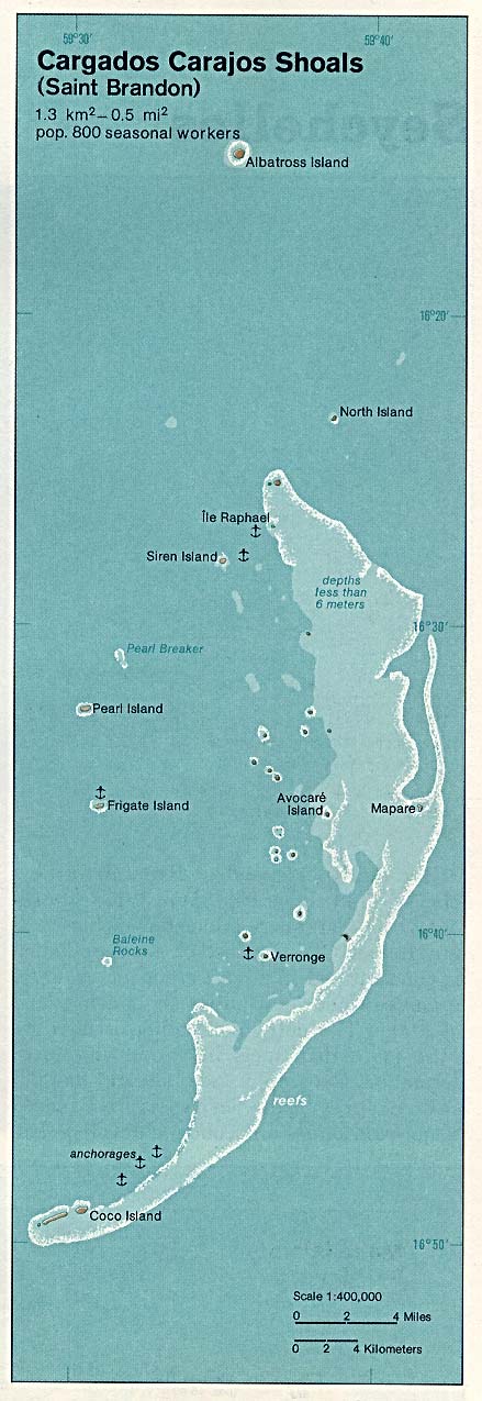
native name = Saint Brandon
native name link =
location =Indian Ocean
coordinates= coord|16|35|S|59|37|E|region:MU_type:country|name=PAGENAME |display=title,inline
archipelago =
total islands = 16
major islands = Albatross Island, Raphael, Avocaré, Cocos Island and Île du Sud
area = 1.3 km²
highest mount =
elevation =
country = Mauritius
country admin divisions title =
country admin divisions =
country largest city =
country largest city population =
country 1 =
country 1 admin divisions title =
country 1 admin divisions =
country 1 largest city =
country 1 largest city population =
country 2 =
country 2 admin divisions title =
country 2 admin divisions =
country 2 largest city =
country 2 largest city population =
population =
population as of =
density =
ethnic groups =Cargados Carajos Shoals (also known as the Saint Brandon Rocks) are a group of about 16 small islands and islets on an extended
reef in theIndian Ocean northeast ofMauritius . The islands have a total land area of 1.3 km². The reef measures more than 50 km from north to south, and is 5 km wide, cut by three passes. The reef area is 190 km². The islands have a small population of Creoles, made up mostly of natives as well a small group from Mauritius, and are rich in flora and fauna. The islands are classified as a dependency of Mauritius, which is more than 300 km south, and are administered fromPort Louis . The islands are part of theMascarene Islands .In the past, Cargados Carajos was a large, volcanic island (part of the Mascarenes, caused by the
Réunion hotspot ). Over time however, the island eroded until it became submerged and a coral atoll was left behind.The formation might be considered an
atoll . Individual islets on the reef include, from north to south, with their respective locations:*Albatross Island coord|16|19|0.0|S|59|36|0.0|E |name=Albatross Island |region:MU_type:isle
*Îlot du Nord (North Island) coord|16|19|0.0|S|59|39|0.0|E |name=Îlot du Nord |region:MU_type:isle
*Île Raphael coord|16|27|0.0|S|59|37|0.0|E |name=Île Raphael |region:MU_type:isle
*Îlot Siren coord|16|28|0.0|S|59|34|0.0|E |name=Îlot Siren |region:MU_type:isle
*Île Tortue coord|16|28|0.0|S|59|41|0.0|E |name=Île Tortue |region:MU_type:isle
*Pearl Islet (Île Perle) coord|16|31|0.0|S|59|32|0.0|E|name=Pearl Islet |region:MU_type:isle
*Île du Sud coord|16|32|0.0|S|59|32|0.0|E |name=Île du Sud |region:MU_type:isle
*Avocare Island (Avoquer) coord|16|35|0.0|S|59|40|0.0|E |name=Avocare Island |region:MU_type:isle
*Mapare Islet coord|16|35|0.0|S|59|41|0.0|E |name=Mapare Islet |region:MU_type:isle
*Frigate Islet (Île Frégate) coord|16|37|0.0|S|59|31|0.0|E |name=Frigate Islet |region:MU_type:isle
*Îlote du Paul coord|16|37|0.0|S|59|33|0.0|E |name=Îlote du Paul |region:MU_type:isle
*Baleine Rocks coord|16|41|0.0|S|59|30|0.0|E |name=Baleine Rocks |region:MU_type:isle
*Île Veronge (Verronge) coord|16|41|0.0|S|59|37|0.0|E |name=Île Veronge |region:MU_type:isle
*Veronge Ilot coord|16|42|0.0|S|59|38|0.0|E |name=Veronge Ilot |region:MU_type:isle
*Palm Islet coord|16|45|0.0|S|59|35|0.0|E|name=Palm Islet |region:MU_type:isle
*Coco Island (île aux Cocos) coord|16|50|0.0|S|59|30|0.0|E |name=Coco Island |region:MU_type:isle
*Grande Capitane coord|16|40|0.0|S|59|50|0.0|E |name=Grande Capitane |region:MU_type:isle
*Petite Capitane coord|16|36|0.0|S|59|34|0.0|E |name=Petite Capitane |region:MU_type:isle
*Puits A Eau coord|16|39|0.0|S|59|34|0.0|E |name=Puits A Eau |region:MU_type:isle
*Île Poulailer coord|16|44|0.0|S|59|46|0.0|E |name=Île Poulailer |region:MU_type:isle
*Chaloupe coord|16|49|0.0|S|59|50|0.0|E |name=Chaloupe |region:MU_type:isle
*Courson coord|16|48|0.0|S|59|30|0.0|E |name=Courson |region:MU_type:isleA number of unnamed islands and sand
cay s complete the Cargados. The total number of islands on the reef is close to 40.Siren Island, Pearl Island (Île Perle), Frigate Island (Île Frégate) are west of the reef, while North Island (Île du Nord) is about 4 km Northeast of the northern tip of the reef.
Albatros Island, about 18 km north, is geographically a separate single
coral island at location 16°16'S, 59°35'E.Albatros Island is the highest (its highest point is 6 m above sea level) and the largest of the islands in the group, with an area of 1.01 km², followed by Raphael, Avocaré, Cocos Island and Île du Sud.
The main settlement is on Raphael, comprising a privately owned commercial fishing station (with a minimum of 35 resident employees), a coast guard and meteorological station (with eight residents in 1996). Smaller settlements exist on Avocaré, Cocos, and Sud; the settlement on Albatros was abandoned in 1988.
Coconut trees can be found on a few islands as well as bushes and grass.The islands are covered with white granular sand from eroded
coral , and a thick layer ofguano can be found in most places.Sea turtles take advantage of the low population of the islands and lay eggs on their beaches. It's problematic how long this refuge will exist without international protection, as the Mauritius economy is among the fastest growing on earth. The price ofsugar (Mauritius 's main crop, introduced by the French; it represents 17% ofMauritius 's exports) is dropping and tourism is filling the economic gap.The atoll may have been discovered c. 600s CE by
Arabian sailors. It was named in 1506 by Portuguese sailors who put ashore forprovisioning on their way toIndia . In 1598 the Dutch occupied the islands. The islands became a French protectorate in 1722 and passed to British hands in 1810. However, the name "Cargados Carajos" is Spanish for " [heavily] loadedcrow's nest s".Pirates have used the islands as a refuge. In modern times the islands were mined forphosphates (guano ). Mining ceased mid-twentieth century.Cargados comprises about 190 km² of reefs. It has perhaps the largest algal ridge in the Indian Ocean. The reefs of Mauritius have been overfished and have suffered from the effects of tourism and other development. Mauritius plans to establish two marine reserves of
coral reefs that were proposed for protection in 1974, when Mauritius was still a British protectorate. This may demonstrate the pace of protection of natural resources in the area, slowed by the complications of new independence.References
* [http://mitglied.lycos.de/dc3mf/Carcar.htm Further information on Cargados Carajos]
*
* [http://mauritius.africa-atlas.com/ Map of Mauritius]
* [http://www.phelsumania.com/public/articles/biogeography_dispersal_mascarenes.html Dispersal of the Genus Phelsuma in the Mascarenes]
* [http://www2.environnement.gouv.fr/icri/Site_ICRI/activit%C3%A9s%2095-98/Regional%20Workshop/Western%20indian%20ocean.htm The Developing Western Indian Ocean (WIO) Coral Reef Programme]Template group
list =
Wikimedia Foundation. 2010.