- Dimapur district
-
This article is about the district. For its eponymous headquarters, see Dimapur.
Dimapur district — District — A market in Dimapur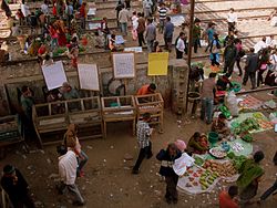 Dimapur district's location in Nagaland
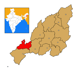
Coordinates: 25°48′N 93°47′E / 25.8°N 93.783°ECoordinates: 25°48′N 93°47′E / 25.8°N 93.783°E State Nagaland Country India Seat Chumukedima Area - Total 927 km2 (357.9 sq mi) Elevation 260 m (853 ft) Population (2011) - Total 379,769 - Density 409.7/km2 (1,061.1/sq mi) Time zone IST (UTC+05:30) ISO 3166 code IN-NL-DI Website http://dimapur.nic.in/ Dimapur (Hindi: दीमापुर ज़िला Dīmāpur Zilā) is a district of Nagaland state in India. Its headquarters is Chumukedima. As of 2011 it is the most populous district of Nagaland (out of 11).[1]
Contents
History
Dimapur district was inaugurated as the eighth district of Nagaland in December, 1997. Earlier it was a sub-division under Kohima district.
Geography
The district is bounded by Kohima district on the south and east, Karbi Anglong district of Assam on the West, the Karbi Anglong and stretch of Golaghat District of Assam, in the west and the north.
A large area of the District is in the plains with an average elevation of 260 m above sea level excepting the Medziphema sub-division and a few villages of Niuland sub-division, which are located in the foothills. The total area of Dimapur is 927 km2 (Source-Deptt. of Land Record & Survey). The district is bounded by Kohima District on the south and east; the Karbi Anglong and the DAB (Disputed Area Belt) stretch of Golaghat District of Assam, in the west and the north 25º 54’ 45” N Latitude 93º 44’ 30” E Longitude.
Climate
Dimapur Climate is hot and humid in the plains during summer (reaching a maximum of 36°C, with humidity up to 93%) while the winter months are cool and pleasant. The average annual rainfall is 1504.7 mm
Economy
Besides being referred to as a gateway of Nagaland and Manipur, main commercial activities of the State, is centered around Dimapur.
Divisions
Administratively, The government of Nagaland, for administrative purpose has established four sub-divisions; Nuiland and Medziphima with Additional Deputy Commissioner as the administrative head and Kuhuboto and Dhansririphar sub-divisions headed by Sub-divisional Officer. Also the district administrative headquarter is currently located at Dimapur, headed by the Deputy Commissioner. The new administrative complex that would also house the Deputy Commissioner Office is under construction at Chumukedima(about 20 km from Dimapur town).
The Following officers are responsible for the running of district administration:
1. The Deputy Commissioner (DC) at Dimapur heads the District.
2. Additional Deputy Commissioner (ADC) Headquarters at Niuland
3. Sub-Divisional Officer SDO (C) Headquarters at Medziphema, Kuhuboto and Dhansiripar.
4. Extra Assistant Commissioner (EAC) Headquarters at Nihokhu,
Demographics
It has a population of 379 769 and a literacy rate of 85.4%.[2] (2011)
The District has a heterogeneous population with the majority comprising Naga tribes from all over Nagaland.
Flora and fauna
In 1986 Dimapur district became home to the Rangapahar Wildlife Sanctuary, which has an area of 4.7 km2 (1.8 sq mi).[3]
Education
The district has ample number of institutions devoted for providing quality education to the residents. Most schools have English as their medium of instruction and are affiliated to the Nagaland Board of School Education. Some prominent schools include Patkai School, Holy Cross School, Pranab Vidyapith, Government High School,M.g.m higher secondary school etc.
- Colleges
- Patkai Christian College (the only autonomous college in Northeast India), Dimapur Government College,, Public College of Commerce, S.D. Jain College, Pranabananda Women’s College, Salt Christian College, Tetso College are a few among the 18 different Colleges in Dimapur. Hostel accommodation is also available in few Colleges.
- Vocational Centres
- Women’s’ Industrial Training Institute (WITI) run by the Dept. of Employment, besides many private IT institutions imparting vocational/skilled training.
References
- ^ "District Census 2011". Census2011.co.in. 2011. http://www.census2011.co.in/district.php. Retrieved 2011-09-30.
- ^ "District Census 2011". Census2011.co.in. http://www.census2011.co.in/district.php.
- ^ Indian Ministry of Forests and Environment. "Protected areas: Nagaland". http://oldwww.wii.gov.in/envis/envis_pa_network/index.htm. Retrieved September 25, 2011.
External links

Golaghat district, Assam Karbi Anglong district, Assam 
Kohima district  Dimapur district

Peren district Districts of Nagaland Categories:


Wikimedia Foundation. 2010.