- Aspirant states of India
-
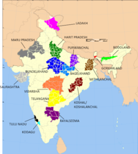 Map of India showing most of the aspirant states: #Anga Pradesh(Brown) #Ladakh (Pink) #Harit Pradesh (Dark Green) #Maru Pradesh (Dark Grey) #Bundelkhand (Dark blue) #Bagelkhand (water blue) #Purvanchal (Purple) #Mithila #Gorkhaland (red) #Bodoland (light green) #Saurashtra (light grey) #Vidarbha (Orange) #Telangana (Yellow) #Rayalaseema (Dark Pink) #Tulu Nadu (Black) #Kodagu (sky blue) #Kosal (Maroon)
Demands for the creation of new states have been a chronic feature of the Indian polity since the inception of the republic. Such agitations typically base themselves on claims of neglect or discrimination meted out to them by the central or relevant state governments. Some such ongoing agitations are chronicled here.
Contents
Bodoland
The agitation for the creation of a separate Bodoland state resulted in an agreement between the Indian Government, the Assam state government and the Bodo Liberation Tigers Force. Per that agreement of February 10, 2003, the Bodoland Territorial Council, an entity subordinate to the government of Assam, was created to govern four districts covering 3082 Bodo-majority villages in Assam.[1] The text of the agreement can be found here. Elections to the council were held on May 13, 2003, and Hagrama Mahillary was sworn in as chief of the 46-member council on June 4, 2003.[2]
Delhi
Both Delhi is anUnion Territories with its own legislatures and chief ministers, but not yet full state. The previous National Democratic Alliance government introduced a bill in parliament to grant full statehood to Delhi, but the legislation has yet to be passed.[3]
Gorkhaland
Main article: GorkhalandA violent struggle for a state of Gorkhaland by the Gorkha National Liberation Front in the 1980s resulted in the formation of the Darjeeling Gorkha Hill Council in 1988. However, the aspirations of the people of Darjeeling and the surrounding areas were not fulfilled and the demand for full statehood emerged once again in 2007 with the Gorkha Janmukti Morcha as its chief proponent. After the West Bengal state assembly election, 2011, the Gorkha Janmukti Morcha has signed an agreement with the state government to establish a Gorkhaland Territorial Administration to replace the DGHC.[4]
Harit Pradesh
There is a demand to carve out separate state of Harit Pradesh out of Uttar Pradesh. Harit Pradesh would comprise parts of Western Uttar Pradesh. The proposed state would include 22 districts in Six divisions – Meerut, Saharanpur, Moradabad, Bareilly, Agra and Aligarh. Cultural and economical differences between Eastern and Western part of Uttar Pradesh are the main reason behind the demand of Harit Pradesh. At the village level, some commentators have observed that Western Uttar Pradesh resembles Haryana and Rajasthan more than it does Eastern Uttar Pradesh.
The most prominent current-day advocate for the creation of the new state is Ajit Singh, the leader of the Rashtriya Lok Dal party. Mayawati also supported the formation of Harit Pradesh in December, 2009.
Kosal
Main articles: Koshal and Koshal State MovementKosal, also known as Dakhin Kosal,Kosala or Koshal, is the ancient name of present day’s Western Orissa and Chhattisgarh state, which is referenced many times in Indian epics like the Puranas, the Ramayana and the Mahabharata.Kosal was surrounded by Radha (comprising present day Mayurbhanj district in Orissa, and Midnapur and Hugli district of in West Bengal) on the east. River Brahmaniwas is its eastern border. On the west of Kosal, the Rashtrikas were ruling their kingdom. Maikhala range and River Sionath were the western borders of Kosal.River Godavari and Indravati were bordering Kosal on the south and separating it from the Andhra. In the north river Kanahar, the tributary of river Shon was separating Kosal from Magadh. In medieval period this western Orissa region was known as Hirakhand or Samalpur kingdom.
The Chinese philosopher, Huen Tsang, has mentioned in his book that from Kalinga he went north- west for 1800 li to Kosal, a country which was more than 6000 li in circuit, and its capital was above 40 li in circuit. It is further been noted that the country was called “South Kosal“, apparently to distinguish from the Kosal in North.
The Kosal region in Orissa state lies between 19º 37’- 23º N latitude and 82º 28’- 85º 22’ E longitudes comprising the districts of Sundargad, Jharsuguda,Debgad, Samalpur, Bargad, Sonepur, Baud, Balangir, Nuapada, Kalahandi, Nabarangpur, Aathmallik sub-division of Angul district. and Kashipur block of Rayagad district. It is surrounded by Jharkhand state on the north, on the east by the dist of Kendujhar, Angul and Kandhamal; on the south by Rayagada, Koraput and on the west by Chhattisgarh state.
The total area of Kosal is 55,693.06 km2 (excluding the area of Athmallik sub-division of Angul district). It comprises 32.35% of the total area of Orissa state. The cultivable area in this part of state is 15,452 km2 and irrigated area is 2,199 km2.
Total population : 1,00, 30,999 (2001 census)
Rural population : 63.7% of the total population
Urban population : 36.3% of the population
Literacy : 55.50%
Male Female ratio : 1000:976
These districts occupy 32.35% of the total geographical area (excluding Athmallik as data is not available) and 24.55% of the total population of Orissa. British Commissioner Hunter Sahib had coined the term Western Orissa for the first time when it became part of newly formed Orissa division of East India Co in 1905 AD. This geographical area is also recognised by state government of Orissa as the area under Western Orissa development council (WODC).
Many of the common generalisations of history that are made about Orissa do not seem to be applied to this region. Its different historical background and geographical location has helped it to develop a distinct cultural identity, language, social behavior and practice of its own which makes it different from the rest of the state. The language spoken throughout this stretch is popularly known as “Samalpuri” or “Sambalpuri”, which is way apart from the state official language “Oriya” by means of vocabulary, grammar and pronunciation. People use Oriya as a medium of education in school where as for day to day life they use Samalpuri. It becomes very difficult for kids to learn and acquire a new language other than their mother tongue at an early stage. There is a consciousness growing among intellectual mass of Western Orissa to recognise this language in the 8th schedule of the Indian constitution as Kosli or Samalpuri.
Ex-Member of Parliament from Debgarh Mr SriBallbha Panigrahi and Ex-Member of Parliament from Sambalpurconstituency Sri Prasanna Acharya have raised their voice for this cause in two different instances in the Parliament (Lok Sabha).
The language is transforming rapidly from a speaking language to a full fledge one. So many poets, writers have already written many great epics in this language. This Kosli language has cross border presence and spoken widely in Saraipali, Basna, Sarangad, Raigad, Jaspore area of Chhattishgarh state and some part in Jharkhand state too. Within the Orissa state, it is spoken in some part of Keojhar, Nabarangpur districts, Niyamagiri area in Rayagada dist and also spoken by tribal of Daspalla region in Nayagarh dist other than the core Kosli belt such as Sundargad, Jharsuguda, Debgad, Samalpur, Bargad, Sonepur, Baudh, Balangir, Nuapada, Kalahandi and Athhamallik sub-division in Angul dist.
This region is famous for its world famous Sambalpuri handlooms and vibrant rhythmic folk music popularly known asSamalpuri geet or gana.
Mithila
The ongoing demand for Mithila state is more on the underdevelopment keeping the boundaries where Maithili is spoken as per the Linguistic Survey of India by GA Grierson in 1904-28 which included:the then districts of Muzaffarpur, Darbhanga, Bhagalpur, Monghyer, Purnea, Santhal Paragana which now after several bifurcations of districts consists of twenty four Maithili speaking districts currently in Bihar and six in Jharkhand (Mithila protagonists also claim East Champaran and West Champaran on epical reason when it was in Mithila and also on economic and agro-climatic reasons).
"Grierson judged that Maithili and its dialects could fairly be characterized as the language of the entire population of Darbhanga and Bhagalpur districts and of a majority or a significant minority of the populations of Muzaffarpur, Monghyer, Purnea and Santhal Parganas.[5]
The Mithila protagonists demand the above districts which presently are divided in many districts – in Bihar states’ districts:- Darbhanga is divided in – Darbhanga, Madhubani and Samastipur Bhagalpur is divided in – Supaul, Saharasa, Madhepura, Bhagalpur, Banka Muzaffarpur is divided in Muzaffarpur, Sheohar,Sitamarhi and Vaishali Monghyer is divided in Monghyr,Begusarai, Khagaria, Lakhisarai, Sheikhpura and Jamui Purnea is divided in Purnea, Araria, Kathihar and Kishanganj - Jharkhand’s Santhal Parganas is divided in Godda, Devghar, Dumka, Jamtara, Sahibganj and Pakur.
People of all districts of the proposed Mithila state do speak Maithili. The fact is that parts of proposed Mithila, so-called Angika Language protagonists do claim Angika is spoken by the people, still Angika is not recognised as a separate language by the Sahitya Akademy,the apex body of literature in India and including George A. Grierson, the convention is to treat the speech as a dialect of Maithili. The other recognized language of proposed Mithila is Santhali in the south of Ganga. Maithili is only language of the region which has a vast treasure of literature, the earliest book is Varn ratnakar of 1224 AD.
During the 1950s at the time of the First State Reorganization Committee, Maithli was not put on the Indian Government schedule of recognized languages. Since then, there has been a strong push to see it reinstituted on the schedule. In 2003 the push was successful and Maithili was recognized on the VIII schedule of the Indian Constitution and once again given its proper status as a major Indian language.
In spite of the fact that only a part of the Mithila population were enumerated in the 2001 Indian Census, 12,179,122 Maithili speaking persons were identified making Maithli the thirteenth most popularly spoken language in India(vide website of the Census of India 2001). Of the 28 states of the Indian Union, 25 of them were established on the basis of language. Three of the newer states were established on the basis of economic backwardness and culture. A strong argument for a Mithila state can be made based on all three criteria; language, culture and economic need.
As seen that no one can to develop the mithla but they came to enjoy in mithla region (officers or MPs or MLAs or MLCs in our areas, no ask them about why you did not the road or rail route or electricity or many other things in our region. who is responsible for this?????? we r responsible for this, but no one accept this truth. only tell want separate state any where in India. this is also truth that political parties devide the UK from UP, Jharkhand From Bihar or CHG from MP only forthe "LOOT" of their natural resources, as u seen in news paper or Tv channel, this is original status of deviding the state as earlier.......
Purvanchal
Purvanchal is a geographic region of north-central India, which comprises the eastern end of Uttar Pradesh state. It is bounded by Nepal to the north, Bihar state to the east, Bagelkhand region of Madhya Pradesh state to the south, the Awadh region of Uttar Pradesh to the west. Purvanchal comprises three divisions – Awadhi region in the west, Bhojpuri region in the east and the Baghelkhand region in the south.
The most commonly spoken language in Purvanchal is Bhojpuri.
Purvanchal area is represented by 23 Members of Parliament to the lower house of Indian Parliament, and 117 legislators in the 403 member Uttar Pradesh state assebly or Vidhan Sabha.[6] Districts-Azamgarh,Ballia,Chandoli, Deoria,Ghazipur,Gorakhpur, Jaunpur,Kushinagar,Maharajganj,Mau ,Mirzapur,Sant Kabir Nagar, Sant Ravidas Nagar, Siddharth Nagar,Varanasi.
As a fallout of Telangana creation movement, Mayawati proposed Dec 13th, 2009 to carve Purvanchal.[7] out of Uttar Pradesh. Current movement for Purvanchal is spearheaded by famous politician Amar Singh.
Telangana
Main article: TelanganaTelangana comprises the northern, non-coastal districts of Andhra Pradesh, and includes the state capital, Hyderabad. The separate Telangana state movement started in 1950s when people unhappy with the merger with Andhra State expressed their discontent. In 1969, there was a full blown revolution by the students of Hyderabad that was controlled and 369 students were killed in police shootings. The demand has since been growing in people's hearts and became the tide-turner in all general elections from the year 2000. The Telangana Rashtra Samithi (TRS) is a political party formed on the single-point-agenda of formation of Telangana State. TRS in 2004, contested parliamentary elections in alliance with the Congress party and won 5 of 16 seats in the region. This rendered it a member of the coalition ruling India, and a carefully worded sentence about considering the demand for the creation of a new state "at an appropriate time" was duly included in the Common Minimum Programme.[8] TRS chief K Chandrashekhar Rao sat for a fast-unto-death on 30th Nov, 2009 demanding formation of the state. On 9th Dec 2009, Home Minister P. Chidambaram announced an "appropriate resolution" for a Telangana state formation. But it has later put on hold due to pressures and causes from politicians and people from seemandhra ( costal and Rayalaseema) to prosper as united.
Tulu Nadu
Main article: Mangalorean regionalismThe demand for creation of a separate state of Tulu Nadu, a prosperous region of Karnataka and Kerala, is based on having a different language (Tulu). Tuluvas are culturally not very distinct from the rest of Karnataka. Despite this Tuluvas have been demanding a separate state, or at least autonomy. Both the Karnataka and Kerala state governments have created Tulu Sahitya Academy- for the preservation and promotion of Tuluva culture, and to counter this accusation of cultural neglect.[9]
Vidarbha
Vidarbha comprises the Amravati and Nagpur divisions in eastern Maharashtra. After British conquests from Mughals and Marathas in central India, Nagpur Province of British India was formed in 1853 with Nagpur as the capital. In 1861, "Central Province" was formed, with Nagpur as capital. In 1935, the Government of India Act, passed by British parliament, formed provincial assembly. Indian National Congress won a majority of seats and Narayan Bhaskar Khare became the first chief minister of Central Provinces in August 1937. In 1946 elections, Ravi Shankar Shukla became chief minister of Central Provinces and Berar, with Nagpur as capital. In the 1950 constitution of India, the state was renamed Madhya Pradesh. In 1953, the States Reorganisation Commission was formed by the Central Government of India, with Fazal Ali, Kavalam Madhava Panikkar, and Hridyanath Kunzru as members.
The State Reorganization Act of 1956 was passed by the central government and Vidarbha became a part of Bombay state. Shortly after this, a plan to create a "Vidarbha state" with Nagpur as the capital was recommended by the state reorganization commission. Under pressure from the leaders of western Maharashtra, Maharashtra state was formed on 1 May 1960, thus continuing Vidarbha's dominance by the Maharashtra.
Support for a separate state of Vidarbha had been expressed by Loknayak Bapuji Aney and Pt Brijlal Biyani Vidarbha. The demand for the creation of a separate Vidarbha state is based in large part on these historical facts.
Allegations of neglect by the Maharashtra state government also are part of the issue. Jambuwantrao Dhote led a popular struggle for Vidarbha statehood in the 1970s. Two politicians, N.K.P. Salve and Vasant Sathe, have led 21st century attempts to bring about a state of Vidarbha.[10]
The demand has never enjoyed popularity as it was always raised by leaders of the Congress Party and Bharatiya Janata Party (BJP) from Vidharbha.
This situation has begun to change with a young leader from Nagpur, Nitin Gadkari becoming the president of the BJP, which is a staunch supporter of a separate Vidarbha state.
The other complex point is the inclusion of old Berar Province or the Amravati division comprising the districts of Amravati, Buldhana, Akola, Washim and Yavatmal districts. People in this western part of Vidharbha or the old Berar province are culturally, socially and politically more similar to Khandesh and Marathwada regions in Maharashtra. They were also part of the former Nizam's Hyderabad province, before being added to the former Central Provinces and Berar province.
[edit] Vindhya Pradesh
Vindhya Pradesh
Vindhya Pradesh is a region in Madhya Pradesh & former indian state of India. Area 23,185 sq. miles. It was created in 1948, shortly after Indian independence, from the territories of the princely states in the eastern portion of the prev Central India Agency named after the Vindhya Range, located here. The capital of the Vindhya Pradesh was Rewa. It lays between Uttar Pradesh to the north and Chattisgarh to the south, and in the west surrounded by the state of Madhya Bharat.
Recent Activities
In 2000, Sriniwas Tiwari, ex-speaker of the Madhya Pradesh assembly, advocated that nine districts be separated from Madhya Pradesh to re-create a new state of Vindhya Pradesh. Various organizations like Vindhaya Ekata Parishad, and Vidhya Punrodaya Samiti are actively working for the separate "Vindhya Pradesh".
Case for making the cosmopolitan metros separate states
One section of people, specially, hail from Coastal and Rayalseema region of Andhra Pradesh, who settled in Hyderabad have raised the slogan for Separate Hyderabad state or Union Territory. But most of the native Hyderabadis, MIM and Telangana people are against to this demand. There were similar demands raised in Mumbai for separate state or union territory amid MNS verbal and physical attacks on non Marathi people. But Shiv Sena chief Bal Thackeray has said that he would ‘crush’ anyone who speaks about a separate state of Mumbai[10]. Till now, no registered or recognized political party supported 'separate state' or 'UT status' to Hyderabad or Mumbai. [11] [12] [13]
Others
- Andaman & Nicobar Islands
- Anga Pradesh Angika speaking state in Bihar. Angika has more than 30 Million speakers in India.[14] Angika has its own traditional script- Anga Lipi.
- Awadh state consisting of Awadhi speaking districts of central Uttar Pradesh. The population of proposed state would be approximately 5crores (50 million people) with an area of approximately 75,000 km2 and capital at Lucknow.[1][2]
- Bhojpuri speaking state comprising Eastern Uttar Pradesh and parts of Bihar. Bhojpuri is a major language in India with over 150 million speakers and has a flourishing entertainment industry.[citation needed]
- Braj Pradesh consisting of Agra division and Aligarh division from Uttar Pradesh and districts of Bharatpur and Gwalior from Rajasthan and Madhya Pradesh. The proposed capital would be in Agra.[3][15] So far, Braj has remained as a historical and cultural region, rather than a political entity. Language of Braj is Braj Bhasha.
- Gondwana, which would include portions of Andhra Pradesh, Chhattisgarh, Madhya Pradesh, and Maharashtra.
- Kamtapur in northern parts of West Bengal. The proposed state consists of the districts of Koch Behar, Jalpaiguri, and southern plains of Darjeeling including Siliguri city.
- Karaikal, which include Karaikal district of Pondicherry, demanding UT Statehood for Karaikal which is physically lying 150 km south of Puducherry.
- Mithila or Mithilanchal a Maithili speaking state. Mailthili is an Indo-Aryan language with 45 million speakers. It has its own traditional script. Mathili speaking persons in Mithila are becoming in minority; due to under-numeration,Mathili is on the second position in no of speaking persons in Mithila. Interestingly, due to over-numeration Hindi is the first and Santhali is the third most speaking language in proposed Mithila as per census of 2001.
- Saurashtra, Gujarat: No demands for statehood since quite a time. Situation peaceful as it remains an integral part of Gujarat
- SeemaAndhra. Coastal region of Andhra Pradesh & Rayalseema region. B.N.Srikrishna report's[16] option 2, 4 & 5.
See also
- Autonomous regions of India
- Separatist movements of India
References
Footnotes
- ^ The Hindu : Assam: accord and discord
- ^ "Mahillary sworn in Bodoland council chief". The Hindu (Chennai, India). 4 June 2005. http://www.hindu.com/2005/06/04/stories/2005060401511300.htm.
- ^ The Hindu : Bill on statehood for Delhi cleared
- ^ "‘Gorkhaland Territorial Administration’ it is". The Statesman (Kolkata, India). 8 July 2011. http://www.thestatesman.net/index.php?option=com_content&view=article&id=375936&catid=35.
- ^ Paul R Brass.Language, Religion and Politics in North India (Cambridge: cambridge University Press, 1974),page 64 avaialble on web. Which has quoted Grierson, Linguistic survey, Vol.V, pt.II, pages 13,14,54,118.
- ^ "Congressmen demand separate Purvanchal, Bundelkhand States". The Hindu (Chennai, India). 7 March 2005. http://www.hindu.com/2005/03/07/stories/2005030702770300.htm.
- ^ Maya challenges Pranab over statehood - timesnow.tv
- ^ The Hindu : National : Demand for Telangana to be considered at `appropriate time'
- ^ Beltangady: Litterateur Kudyady Vishwanath Rai Voices Need for Tulunadu State
- ^ http://www.expressindia.com/news/fullstory.php?newsid=49109
- ^ http://www.indianexpress.com/oldStory/72733
- ^ http://www.siasat.com/english/news/mim-against-union-territory-status-hyderabad
- ^ http://www.deccanchronicle.com/channels/cities/hyderabad/will-not-compromise-hyderabad-says-kcr-113
- ^ "Angika.com". http://www.angika.com.
- ^ 'Braj Pradesh' State Demand Intensifies - Indiaserver.com
- ^ The Hindu (Chennai, India). http://www.hindu.com/nic/srikrishna_fullreport.pdf.
Notations
- The Hindu : Karnataka / Mangalore News : Tulu Nadu movement gaining momentum
- News headlines
- Look India Blog
Aspirant states of India Bodoland (Assam) · Bundelkhand (Uttar Pradesh and Madhya Pradesh) · Delhi · Gondwana (northern Deccan Plateau) · Gorkhaland (West Bengal) · Harit Pradesh (Uttar Pradesh) · Kamtapur / Greater Cooch Behar (West Bengal) · Karbi Anglong (Assam) · Kodagu (Karnataka) · Kongu Nadu (Tamil Nadu) · Kosal/Koshal (Orissa) · Ladakh (Jammu and Kashmir) · Mahakoshal (Madhya Pradesh) · Mithila (Bihar) · Panun Kashmir (Jammu and Kashmir) · Purvanchal (Uttar Pradesh) · Rayalaseema (Andhra Pradesh) · Telangana (Andhra Pradesh) · Tulu Nadu (Karnataka and Kerala) · Vidarbha (Maharashtra) · Maru Pradesh (Rajasthan) · Vindhya Pradesh (Madhya Pradesh) Categories:
- Politics of India
- Proposed states and union territories in India

Wikimedia Foundation. 2010.