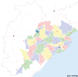
- Cuttack district
-
Cuttack Silver City — district — Coordinates 20°27′58″N 85°49′59″E / 20.466°N 85.833°ECoordinates: 20°27′58″N 85°49′59″E / 20.466°N 85.833°E Country India State Orissa Nearest city Bhubaneswar Parliamentary constituency Cuttack Assembly constituency 10 Population
• Density
2,618,708 (2nd) (2011[update])
• 666 /km2 (1,725 /sq mi)
Sex ratio 955 ♂/♀ Literacy
• Male
• Female84.20%
• 90.51%
• 77.64%Official languages Oriya, Hindi, English Time zone IST (UTC+05:30) Area 3,932 square kilometres (1,518 sq mi) Climate
• Precipitation
Temperature
• Summer
• WinterAw (Köppen)
• 1,501.3 mm (59.11 in)
• 40 °C (104 °F)
• 10 °C (50 °F)Distance(s)-
• From • 23 kilometres (14 mi) S (land)
Website Cuttack website Cuttack district is one of the 30 districts in Orissa state in eastern India. Its administrative headquarters is the city of Cuttack. As of 2011 it is the second most populous district of Orissa (out of 30), after Ganjam.[1]
Contents
Geography
The district covers an area of 3932 km². The district has a population of 2,341,984 (2001 Census).
Divisions
This district was subdivided into 15 Tehsils and 14 Revenue Blocks.
The Tehsils are Cuttack, Niali, Salipur, Tangi-Chowdwar, Mahanga, Kishannagar, Athgarh, Baramba, Narasinghpur, Tigiria, Banki, Baranga, Kantapada, Nischintakoili, Damapada. The last four are new Tehsils created in 2008.[2]
Demographics
According to the 2011 census Cuttack district has a population of 2,618,708,[1] roughly equal to the nation of Kuwait[3] or the US state of Nevada.[4] This gives it a ranking of 156th in India (out of a total of 640).[1] The district has a population density of 666 inhabitants per square kilometre (1,720 /sq mi) .[1] Its population growth rate over the decade 2001-2011 was 11.86 %.[1] Cuttack has a sex ratio of 955 females for every 1000 males,[1] and a literacy rate of 84.2 %.[1]
References
- ^ a b c d e f g "District Census 2011". Census2011.co.in. 2011. http://www.census2011.co.in/district.php. Retrieved 2011-09-30.
- ^ http://www.orissa.gov.in/revenue/ADMN_UNIT/adm_unit.htm
- ^ US Directorate of Intelligence. "Country Comparison:Population". https://www.cia.gov/library/publications/the-world-factbook/rankorder/2119rank.html. Retrieved 2011-10-01. "Kuwait 2,595,62"
- ^ "2010 Resident Population Data". U. S. Census Bureau. http://2010.census.gov/2010census/data/apportionment-pop-text.php. Retrieved 2011-09-30. "Nevada 2,700,551"
External links

Anugul district Dhenkanal district Jajapur district 

Kendrapara district  Cuttack district

Nayagarh district Khordha district Jagatsinghpur district
Puri districtState of Orissa · 
Capital 
Topics Districts Angul · Balasore · Bargarh · Bhadrak · Balangir · Boudh · Cuttack · Debagarh · Dhenkanal · Gajapati · Ganjam · Jagatsinghpur · Jajpur · Jharsuguda · Kalahandi · Kandhamal · Kendrapara · Kendujhar · Khordha · Koraput · Malkangiri · Mayurbhanj · Nabarangpur · Nayagarh · Nuapada · Puri · Rayagada · Sambalpur · Subarnapur · Sundargarh
Cities Cities and towns in Cuttack district Cuttack Athagad · Banki · Belagachhia · Charibatia · Choudwar · Cuttack · Dadhapatna · Nuapatna · Manapur
Cities and towns
in other districtsAngul · Balangir · Balasore · Bargarh · Bhadrak · Boudh · Debagarh · Dhenkanal · Gajapati · Ganjam · Jagatsinghpur · Jajpur · Jharsuguda · Kalahandi · Kandhamal · Kendrapara · Kendujhar · Khordha · Koraput · Malkangiri · Mayurbhanj · Nabarangpur · Nayagarh · Nuapada · Puri · Rayagada · Sambalpur · Subarnapur · Sundergarh
Districts of Orissa Angul · Balangir · Balasore · Bargarh · Bhadrak · Boudh · Cuttack · Debagarh · Dhenkanal · Gajapati · Ganjam · Jagatsinghpur · Jajpur · Jharsuguda · Kalahandi · Kandhamal · Kendrapara · Kendujhar · Khordha · Koraput · Malkangiri · Mayurbhanj · Nabarangpur · Nayagarh · Nuapada · Puri · Rayagada · Sambalpur · Subarnapur · SundergarhMahanadi-Brahmani-Baitarani Basin Rivers Dams, barrages Geographical features Dandakaranya • Dakshina Kosala Kingdom • Chota Nagpur Plateau • Western Orissa • Mahanadi River Delta • Bhitarkanika MangrovesRiparian districts Chhattisgarh Dhamtari • Kanker • Raipur • Janjgir-Champa • Raigarh • Jashpur • Korba • Koriya • Surguja Madhya Pradesh Anuppur Jharkhand Gumla • Khunti • Ranchi • West Singhbhum Orissa Jharsuguda • Kendujhar • Mayurbhanj • Sundergarh • Boudh • Angul • Jajpur • Cuttack • Kendrapara • Khordha • Jagatsinghpur • PuriLanguages/ people Coalfields Industries Korba Super Thermal Power PlantTransport Related topics Hydrology of Chhattisgarh • Hydrology of Jharkhand • Hydrology of OrissaCategories:- Cuttack district
- Orissa geography stubs
-
Wikimedia Foundation. 2010.


