- Mahanadi River Delta
-
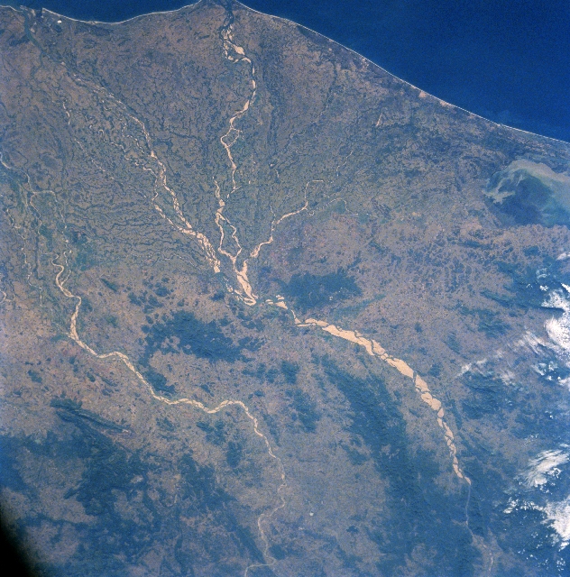
 Mahanadi River Delta - NASA satellite view
Mahanadi River Delta in India is a basin of deposit that drains a large land mass of the Indian subcontinent into the Bay of Bengal. The alluvial valley is wide and relatively flat with a meandering river channel that changes its course.[1]
The Mahanadi River flows slowly for 560 miles (900 km) and has an estimated drainage area of 51,000 square miles (132,100 square km). It deposits more silt than almost any other river in the Indian subcontinent.[2]
The area of the drainage basin is 141,464 km². The interior coastal plain has a relatively low elevation. The average elevation of the drainage basin is 426 m, with a maximum of 877 m and a minimum of 193 m.
Population density
The upper part of the delta plain is heavily populated. The population density exceeds 36 people per km², although moving toward the coast the population density falls.
Rainfall comes predominantly from the summer monsoon (June through September). The average annual rainfall in the basin is 1,463 mm. Rainfall is extremely low during the rest of the year, rarely exceeding 30 mm per month.[3]
Notes
- ^ "Mahanadi River Delta on East Coast of India". http://www.megadelta.ecnu.edu.cn/main/upload/mahanadi.pdf. Retrieved 2006-09-22.
- ^ "Mahanadi River". http://orissagov.nic.in/cmccuttack/mahanadi%20river.htm. Retrieved 2006-09-22.
- ^ "Mahanadi River Delta". http://www.geol.lsu.edu/WDD/ASIAN/Mahanadi/mahanadi.htm. Retrieved 2006-09-22.
External links
- Mahanadi River Delta on East Coast of India
- Flood Forecasting and Inundation Mapping in the Mahanadi River Basin: A Collaborative Effort between India and the United States
- Nasa view of Mahanadi River Delta
Mahanadi-Brahmani-Baitarani Basin Rivers Dams, barrages Geographical features Dandakaranya • Dakshina Kosala Kingdom • Chota Nagpur Plateau • Western Orissa • Mahanadi River Delta • Bhitarkanika MangrovesRiparian districts Chhattisgarh Dhamtari • Kanker • Raipur • Janjgir-Champa • Raigarh • Jashpur • Korba • Koriya • Surguja Madhya Pradesh Anuppur Jharkhand Gumla • Khunti • Ranchi • West Singhbhum Orissa Jharsuguda • Kendujhar • Mayurbhanj • Sundergarh • Boudh • Angul • Jajpur • Cuttack • Kendrapara • Khordha • Jagatsinghpur • PuriLanguages/ people Coalfields Industries Korba Super Thermal Power PlantTransport Related topics Hydrology of Chhattisgarh • Hydrology of Jharkhand • Hydrology of OrissaCategories:- Mahanadi River
- Landforms of India
- River deltas
- India geography stubs
Wikimedia Foundation. 2010.