- National Highway 60 (India)
-
National Highway 60

60
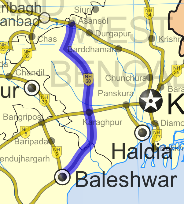
Road map of India with National Highway 60 highlighted in blueRoute information Length: 446 km (277 mi)
GQ: 119 km (74 mi) (Balasore - Kharagpur)Major junctions From: Balasore, Orissa at junction of NH 5 NH 6 at Kharagpur To: Raniganj at junction with NH 2 Location States: Orissa, West Bengal Primary
destinations:Jaleswar - Kharagpur - Bishnupur - Bankura Highway system Indian Road Network
National • Expressways • State
State Highways in ¬← NH 59A NH 60A → National Highway 60 or NH 60 is a National Highway of India that runs from the junction with NH 5 at Balasore to NH 2. It passes through Jaleswar, Dantan, Belda, Kharagpur, Salboni, Bishnupur, Bankura, Gangajalghati, Mejia and Raniganj.
Chandipur is 17 km (11 mi) from Balasore. The Sheoraphuli–Kamarkundu–Tarakeswar–Arambagh Road meets NH 60 at Bishnupur and the Durgapur–Bankura Road (State Highway 9) at Bankura. Total length of NH 60 is 305 km (190 mi) out of which 57 km (35 mi) is in Orissa and 248 km (154 mi) is in West Bengal.[1]
Contents
Floods
There is a feeling that the four-laning and updating of what was earlier known as Orissa Trunk Road is the cause of floods in Balasore district.[2]
References
- ^ "National Highways and their lengths". Ministry of Road Transport & Highways, Government of India. National Highways Authority of India. http://www.nhai.org/nh.asp. Retrieved 2009-02-12.
- ^ "NH-60, a road to disaster". welcomeorissa.com. http://www.welcomeorissa.com/orissa_news.php?opt=view&id=15364&ChosenDay=23&ChosenMonth=06&ChosenYear=2008. Retrieved 2009-02-13.
See also
- List of National Highways in India
- List of National Highways in India (by Highway Number)
- National Highways Development Project
External links
Indian Highways Network National Expressways NE 1 • NE 2


State Expressways Mumbai-Pune • Delhi-Gurgaon • DND Flyway • Bengaluru-Mysore • Chennai HSCTC • Hyderabad Elevated ExpresswaysNational Highways 1 • 1A • 1B • 1C • 1D • 2 • 2A • 3 • 4 • 4A • 4B • 5 • 5A • 6 • 7 • 7A • 8 • 8A • 8B • 8C • 8D • 8E • 9 • 10 • 11 • 11A • 11B • 12 • 12A • 13 • 14 • 15 • 16 • 17 • 17A • 17B • 18 • 19 • 20 • 21 • 21A • 22 • 23 • 24 • 24A • 24B • 25 • 25A • 26 • 26A • 27 • 28 • 28A • 28B • 28C • 29 • 30 • 30A • 31 • 31A • 31B • 31C • 31D • 32 • 33 • 34 • 35 • 36 • 37 • 37A • 38 • 39 • 40 • 41 • 42 • 43 • 44 • 44A • 45 • 45A • 45B • 45C • 46 • 47 • 47A • 47B • 47C • 48 • 49 • 50 • 51 • 52 • 52A • 52B • 53 • 54 • 54A • 55 • 56 • 57 • 57A • 58 • 59 • 59A • 60 • 60A • 61 • 62 • 63 • 64 • 65 • 66 • 67 • 68 • 69 • 70 • 71 • 71A • 71B • 72 • 72A • 73 • 73A • 74 • 75 • 76 • 77 • 78 • 79 • 79A • 80 • 81 • 82 • 83 • 84 • 85 • 86 • 86A • 87 • 88 • 89 • 90 • 91 • 91A • 92 • 93 • 94 • 95 • 96 • 97 • 98 • 99 • 100 • 101 • 102 • 103 • 104 • 105 • 106 • 107 • 108 • 109 • 110 • 111 • 112 • 113 • 114 • 116 • 117 • 119 • 121 • 123 • 125 • 126 • 127 • 128 • 129 • 150 • 151 • 152 • 153 • 154 • 155 • 200 • 201 • 202 • 203 • 203A • 204 • 205 • 206 • 207 • 208 • 209 • 210 • 211 • 212 • 213 • 214 • 214A • 215 • 216 • 217 • 218 • 219 • 220 • 221 • 222 • 223 • 224 • 226 • 227 • 228 • 229 • 234 • 235State Highways Andhra Pradesh • Arunachal Pradesh • Assam • Bihar • Chhattisgarh • Goa • Gujarat • Haryana • Himachal Pradesh • Jammu and Kashmir • Jharkhand • Karnataka • Kerala • Madhya Pradesh • Maharashtra • Manipur • Meghalaya • Mizoram • Nagaland • Orissa • Punjab • Rajasthan • Sikkim • Tamil Nadu • Tripura • Uttarakhand • Uttar Pradesh • West BengalNotable Categories:- National Highways in Orissa
- National Highways in West Bengal
- Golden Quadrilateral
- Indian National Highways
- India road stubs


Wikimedia Foundation. 2010.