- National Highway 79 (India)
-
National Highway 79

79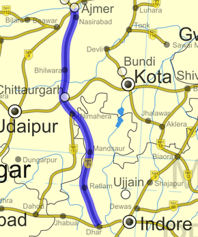
Road map of India with National Highway 79 highlighted in blueRoute information Length: 500 km (300 mi)
GQ: 172 km (107 mi) (Nasirabad - Chittaurgarh)Major junctions From: Ajmer, Rajasthan To: Dhar, Madhya Pradesh Location States: Rajasthan: 220 km (140 mi)
Madhya Pradesh: 280 km (170 mi)Primary
destinations:Nasirabad - Neemuch - Mandsaur Highway system Indian Road Network
National • Expressways • State
State Highways in ¬← NH 78 NH 79A → National Highway 79 (NH 79) is a National Highway that links Ajmer in Rajasthan and Dhar in Madhya Pradesh.[1] The highway is 500 km (310 mi) long, of which 220 km (140 mi) is in Rajasthan and 280 km (170 mi) is in Madhya Pradesh.
Contents
Route
It is very important route of Western Madhya Pradesh & life line of Western M.P. Ajmer is the one end of this national highway and other end is Ghatabillod Dist Dhar(M.P.) which is a small town 40 km (25 mi) away from Indore and aprox. 10 km (6.2 mi) from Mhow. It covers many important industrial, commercial & tourist places i.e. Ajmer(religious place), Nasirabad (Army cantt.), Bhilwara (known for industries), Chittorgarh (Famous tourist place & cement Industries), Nimbahera (cement industries & stone), Nimach (Cement Industries, Agriculture Business, Major Opium crop center & Govt. Opium Factory, Major CRPF Center), Mandsour(known for Pashupatinath temple), Ratlam (Division & Important center of Western Railway), Indore (Commercial Capital of M.P.) and Mhow (A major Army Head Quarter). Now Four Lane road construction is in full swing.
See also
- List of National Highways in India (by Highway Number)
- List of National Highways in India
- National Highways Development Project
References
External links
- [2] NH network map of India
Indian Highways Network National Expressways NE 1 • NE 2


State Expressways Mumbai-Pune • Delhi-Gurgaon • DND Flyway • Bengaluru-Mysore • Chennai HSCTC • Hyderabad Elevated ExpresswaysNational Highways 1 • 1A • 1B • 1C • 1D • 2 • 2A • 3 • 4 • 4A • 4B • 5 • 5A • 6 • 7 • 7A • 8 • 8A • 8B • 8C • 8D • 8E • 9 • 10 • 11 • 11A • 11B • 12 • 12A • 13 • 14 • 15 • 16 • 17 • 17A • 17B • 18 • 19 • 20 • 21 • 21A • 22 • 23 • 24 • 24A • 24B • 25 • 25A • 26 • 26A • 27 • 28 • 28A • 28B • 28C • 29 • 30 • 30A • 31 • 31A • 31B • 31C • 31D • 32 • 33 • 34 • 35 • 36 • 37 • 37A • 38 • 39 • 40 • 41 • 42 • 43 • 44 • 44A • 45 • 45A • 45B • 45C • 46 • 47 • 47A • 47B • 47C • 48 • 49 • 50 • 51 • 52 • 52A • 52B • 53 • 54 • 54A • 55 • 56 • 57 • 57A • 58 • 59 • 59A • 60 • 60A • 61 • 62 • 63 • 64 • 65 • 66 • 67 • 68 • 69 • 70 • 71 • 71A • 71B • 72 • 72A • 73 • 73A • 74 • 75 • 76 • 77 • 78 • 79 • 79A • 80 • 81 • 82 • 83 • 84 • 85 • 86 • 86A • 87 • 88 • 89 • 90 • 91 • 91A • 92 • 93 • 94 • 95 • 96 • 97 • 98 • 99 • 100 • 101 • 102 • 103 • 104 • 105 • 106 • 107 • 108 • 109 • 110 • 111 • 112 • 113 • 114 • 116 • 117 • 119 • 121 • 123 • 125 • 126 • 127 • 128 • 129 • 150 • 151 • 152 • 153 • 154 • 155 • 200 • 201 • 202 • 203 • 203A • 204 • 205 • 206 • 207 • 208 • 209 • 210 • 211 • 212 • 213 • 214 • 214A • 215 • 216 • 217 • 218 • 219 • 220 • 221 • 222 • 223 • 224 • 226 • 227 • 228 • 229 • 234 • 235State Highways Andhra Pradesh • Arunachal Pradesh • Assam • Bihar • Chhattisgarh • Goa • Gujarat • Haryana • Himachal Pradesh • Jammu and Kashmir • Jharkhand • Karnataka • Kerala • Madhya Pradesh • Maharashtra • Manipur • Meghalaya • Mizoram • Nagaland • Orissa • Punjab • Rajasthan • Sikkim • Tamil Nadu • Tripura • Uttarakhand • Uttar Pradesh • West BengalNotable Categories:- National Highways in Madhya Pradesh
- National Highways in Rajasthan
- Golden Quadrilateral
- Indian National Highways
- India road stubs


Wikimedia Foundation. 2010.