- Ajmer
-
This article is about the municipality in Rajasthan, India. For its namesake district, see Ajmer district. For the historical region, see Ajmer region.
Ajmer — city — Pushkar lake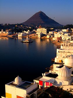
Coordinates 26°27′N 74°38′E / 26.45°N 74.64°ECoordinates: 26°27′N 74°38′E / 26.45°N 74.64°E Country India State Rajasthan District(s) Ajmer Nearest city Jaipur, Jodhpur, Udaipur, Delhi Population 485,197 (2001[update]) Time zone IST (UTC+05:30) Area
• 486 metres (1,594 ft)
Website www.ajmer.nic.in Ajmer (Rajasthani: अजमेर, Urdu: اجمیر) pronounced [ədʒmeːr] (
 listen), formerly written as Ajmere, is a city in Ajmer District in Rajasthan state in India. Ajmer has a population of around 800,000 (2011 census), and is located 135 kilometres (84 mi) west of the Rajasthan state capital Jaipur, 200 km from Jodhpur, 274 km from Udaipur, 439 km from Jaisalmer, and 391 km from Delhi.
Ajmer is surrounded by the Aravalli Mountains. It is a popular Muslim pilgrim city for the shrine or Dargah of the Sufi Saint Khwaja Moinuddin Chishti. It is also the base for visiting Pushkar (11 km), an ancient Hindu pilgrim town for the temple of Brahma. Ajmer is regarded as a center of education in Rajasthan. Ajmer was once known as Ajaymeru, the city ruled by Prithviraj Chauhan. The city has given its name to Ajmer district, and to a former region of British India called Ajmer-Merwara, and to the erstwhile state of Ajmer, which was formed after independence of India, and was incorporated into Rajasthan state on November 1, 1956.
Contents
History
Prithviraj Chauhan of Ajmer (Sanskrit Ajayameru)(It was called' Aj-meru'. Aj is a name synonym to lord Bramha, Meru means hills.Ajmeru means abode hills of lord Bramha) was found in the late seventh century by Dushyant Chauhan. He established the Chauhan dynasty, which continued to rule the country while repeated waves of Turkish invasions swept across India. Ajmer was conquered by Muhammad of Ghor, founder of the Delhi Sultanate, in 1193. Its internal government, however, was handed over to the Chauhan rulers upon the payment of a heavy tribute to the conquerors. Ajmer then remained feudatory to Delhi until 1365, when it was captured by the ruler of Mewar. In 1509 Ajmer became a source of contention between the Maharajas of Mewar and Marwar, and was ultimately conquered by the Marwar ruler in 1532. Ajmer was conquered by the Mughal emperor Akbar in 1559. In 18th century it continued to be in the hands of the Marathas. From that time up to 1818 Ajmer was the scene of an ongoing struggle, being seized at different times by the Mewar and the Marwar maharajas. Since then Ajmer has enjoyed stable governance, although during the 1857 War of Independence some Indian sepoys at the garrison in the nearby town of Nasirabad joined the revolt.
Under the British Raj, Ajmer was governed by an Agent to the Governor General overseeing Rajputana. After independence in 1947, Ajmer retained its position as a centrally administrated state under a Chief Commissioner for some time. Ajmer was eventually merged with the state of Rajasthan.
Geography
 Panoramic Tārāgaṛh Hill,view of Anasagar
 Overlooking beautiful Anasagar lake
The city is situated in on the lower slopes of Gunj Thana (Delhi gate) in the Aravalli Range. It is situated almost in the heart of the state of Rajasthan. To the north of the city is a large artificial lake, called Anasagar, adorned with a marble structure called Baradari. Ajmer is an ancient crowded city with modern developments in the outskirts.
Social Groups
According to Rajputana gazatters of 1879 there are 190 villages in Ajmer, 52 villages are held by Jats, Gujjars hold 51, RajputMers hold 111, 4 are held by other rajputs.Also there is one village of Ahirs.[1][2]
Transportation
Ajmer is well connected to the major cities of India by land, rail and air.
Air
An airport near Ajmer has been proposed by the Government of Rajasthan. It is expected to be operational in the year 2012. At present the nearest airport is the Jaipur International Airport, about 132 km away, with flights connecting several major cities in India.
Rail
Ajmer is at an important railway junction with Broad gauge lines to Jaipur and Marwar, Ahmedabad and Mumbai onwards to Banglaore and a Metre gauge line subject to conversion under Project Unigauge to Udaipur. The railway complex includes a major workshop. The railway has helped the city to connect it with major Indian cities like New Delhi, Mumbai, Kolkata, Chennai, Hydrabad, Bangalore, Ahemedabad, Indore, Bhopal, Gwalior, Jabalpur, Ujjain, Nagpur, Pune, Patna, Lucknow etc. The station is the origin for many far distance trains like Ajmer - Bhopal Express, Ajmer - Indore Link Express, Ajmer - Ratlam Express, Ajmer - Jammu Tawi Pooja Express, Ajmer- chandigarh(garib rath express) etc. Ajmer Railway Station has been identified for development into World Class Station through Public-Private Partnership(PPP) mode.
Road
 From Pushkar to Ajmer, Pushkar ghati
This beautiful city lies on the Golden Quadrilateral National Highway (NH) 8, midway between Delhi and Mumbai, located about 400 km from Delhi and 135 km from Jaipur. RSRTC provides air conditioned bus service from Delhi, Jaipur and other important cities to Ajmer. Both public transportation and private luxury road transport is available to reach the city. The road between Ajmer and Pushkar passes over the mountains and provides with picturesque view of the surroundings. Also the work of 6 lane Expressway between Ajmer Collectorate and Kishangarh is under work, which will reduce the time of 50 minutes to 15–20 minutes between the two. On an average around 7000 vehicles including the tourist buses daily passes through the highway out of which about 2000 are cars going to the Ajmer city.
Inter city transportation
High class comfortable low floor buses are available for inter city transportation and to the near by town including the holy city of Pushkar and the marble city Kishangarh. Unmetered taxis, auto rickshaws, tongas, and regular city bus services run through out the city.
Industries
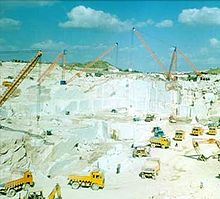 A marble factory in Kishangarh
Ajmer is now a trade center for manufactured goods including cotton, wool textiles, leather, hosiery, shoes, soap, and pharmaceuticals. Poultry farming is a major source of income for the urban farmers. At subdivisional level Ajmer casts engineering workshop, Bread & Biscuit, Flour Mill Parts, Re-rolling Mills, Electronic etc. The HMT Ltd. is a large scale, Enterprises situated at Beawer Road, Ajmer. Manufacturing leath Machine & Machine Tools, other one is Ajmer dairy Producing Milk, Ghee & Butter. The nearby town of Kishangarh is one of the largest markets for marble and marble products. The Investment in marble units is of Rs. 400 Crore. This sector employed 7 thousand direct & indirect persons. Ajmer is well connected with the national highway and is only 135 km (84 mi) from the Jaipur International Airport at Jaipur, which has daily flights to Delhi, Bombay, Chennai, Indore, Pune, etc.
Places of interest
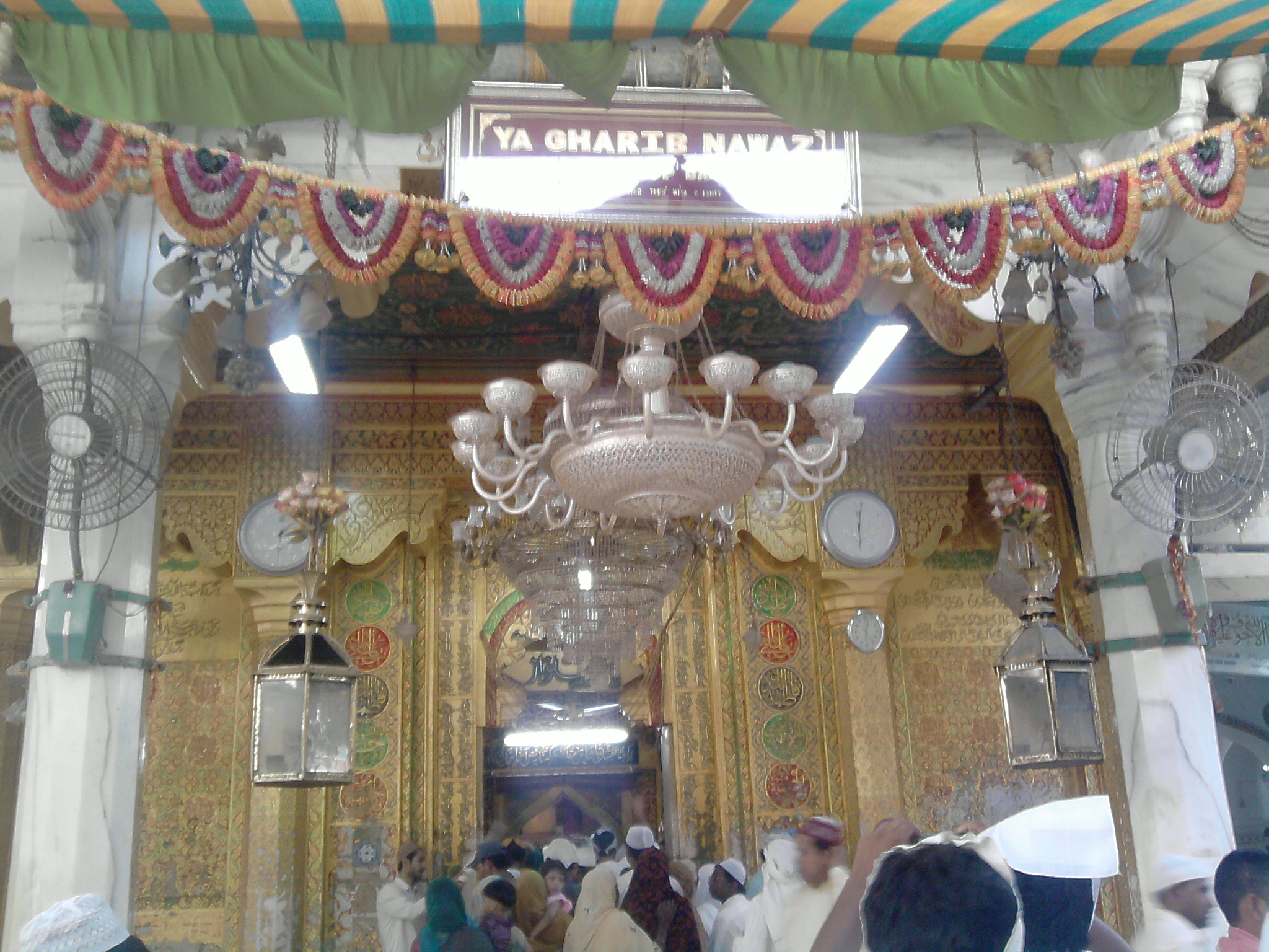
 Inside the Dargah Sharif
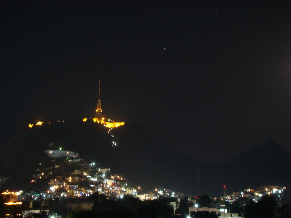
 Night view of Taragarh fort
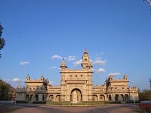 Mayo college in a sunny day
 Lake Foysagar on a Sunny Evening
 Picturesque Nareli
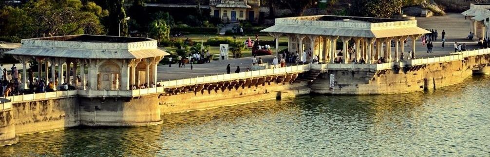
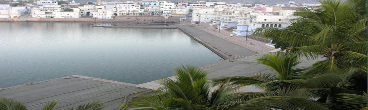
Pushkar is a town in the state of Rajasthan in India near Ajmer, about 11 Kilometers away, and is an important tourist destination. Pushkar is famous for the Pushkar Lake and the 14th century Brahma Temple at Pushkar, dedicated to Brahmā, the Hindu "Creator of the Universe". According to Padma Purāņa Pushkar is the only place where Brahmā may be worshipped.[3] There is general belief among Hindus that no pilgrimage to the four principal pilgrim centres (Char Dham) namely, Badrināth, Jagannāth, Rāmeshwaram and Dwarka, would bear fruit unless one bathes in the holy waters of Pushkar Lake. Pushkar has 52 bathing ghats and many temples, big and small; the most celebrated being that of Brahmā. Pushkar is also famous for its annual Pushkar Fair.
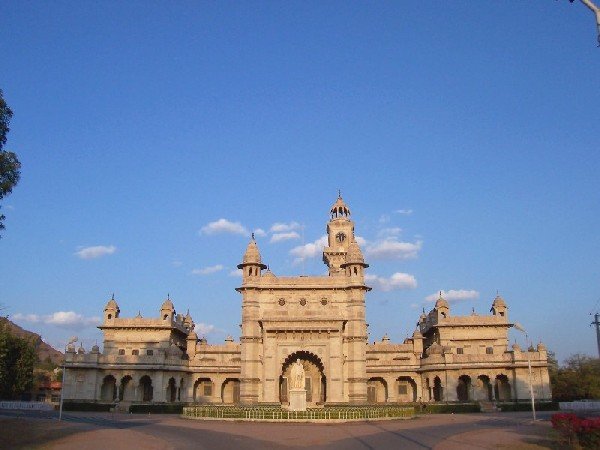
Dargāh Sharīf of Khwāja Mu'īnuddīn Chishtī is situated at the foot of the Tārāgaṛh hill, and consists of several white marble buildings arranged around two courtyards, including a massive gate donated by the Nizām of Hyderabad, a mosque donated by the Mughal emperor Shāh Jahān, the Akbarī Mosque, and the domed tomb of the saint. Akbar and his queen used to come here by foot on pilgrimage from Agra every year in observance of a vow he had made when praying for a son. The large pillars called "Kose ('Mile') Minar", erected at intervals of two miles (3 km) the whole way between Agra and Ajmer, marking the daily halting places of the royal pilgrim, are still extant. On an average 1.25 lac pilgrims visit the shrine daily.
Tārāgaṛh Fort, the fort of Ajmer, seat of the Chauhān rulers, is claimed to be the first hill fort of Asia, built at a time when the Aravalli mountain ranges were above the snowlines. This gives it the reputation of being one of the oldest hill forts of the world, and it is definitely the oldest among the hill forts in India. It was built by King Ajāypāl Chauhān on the summit of Tārāgaṛh Hill, overlooking Ajmer; its thick battlements run along its brow, completely enclosing the table-land. The walls are two miles (3 km) in circumference, and the fort can only be approached by steep and very roughly paved slopes. When it came into the hands of the British Raj, the fort was dismantled by order of Lord William Bentinck, and was converted into a sanatorium for the troops stationed at the British cantonment town of Nasirabad.
Adhāī Din Kā Jhonpdā, a Vaishnava Hindu temple constructed in 1153 and converted into a mosque by Quṭbuddīn Aybak after 1193, is situated on the lower slope of the Tārāgarh hill, additions were made to the mosque between 1220 and 1229 by Aikbak's successor, by Shams al-Din Iltutmish. It is also noted for its double-depth calligraphy inscriptions, in Naskh and Kufic scripts. With the exception of that part used as a mosque, called Jāma' Iltutmish (pronounced Altamish locally), nearly the whole of the ancient temple has fallen into ruins, but the relics are not excelled in beauty of architecture and sculpture by any remains of Hindu art. Forty columns support the roof, but no two are alike, and exceptional creativity is shown in the execution of the ornaments.[4]
Magazine, the city's Museum, was once the residence of Prince Salīm, son of the Emperor Akbar, and presently houses a collection of the Mughal and Rajput armour and sculpture. This residence of Salīm is significant from a historical point of view, because Salīm as Emperor Jahāngīr read out the firman for trade to India to the British East India Company from here, thus starting the chain of events that lead to India's colonisation by the British.
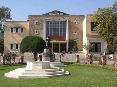
Mayo College was established in 1875 by Lord Mayo, Viceroy of India. The architecture of the school buildings evoke the grandeur of erstwhile princely Rajasthan. The main building of the school, in white marble, is a classic example of Indo-Saracenic architecture, and the design now lies in the archives of the British Museum in London.[5]
Anasāgar Lake. This historic man-made lake Ana Sagar lake was constructed by Maharaja Anaji (1135-1150 AD), the grandfather of Maharaja Prithvirāj Chauhān. By the lake is the Daulat Bāgh, a garden laid out by Emperor Jahāngīr. Emperor Shāh Jahān later added five pavilions, known as the Baradari, between the garden and the lake. A walk through the baradari and chaupati gives wonderful overlooking view of Anasagar lake.
Soniji Ki Nasiyan is an architecturally rich Digambara Jain temple. It was built in 1864-1895 by Gauravji, the Nagar Seth of Ajmer. The main chamber, known as the Swarna Nagari "City of Gold", has several gold-plated wooden figures, depicting characters in the Jain tradition, and was created in Jaipur.
Lake Foy sagar. Situated in the suburb of the city, Lake Foy Sagar is a picturesque artificial lake named after the engineer Mr Foy, an Englishman, who created it under a famine relief project. It is a masterpiece when it comes to artificial lakes. He created it to tackle with harshest conditions of famine under a famine relief project. This artificial lake was constructed in the year 1892. It appears as flat as a pancake, and offers the eye-catching sights of the neighboring Aravalli mountains, as well as evening flights of birds near the lake area.
Around Ajmer
- Kishangarh
- Pushkar
- Beawar
- Todgarh
Annual Fairs
The Pushkar Camel Fair is one of the largest in India and the only one of its kind in the entire world. Pushkar becomes a cultural phenomenon when colourfully dressed devotees, musicians, acrobats, folk dancers, traders, comedians, sadhus and tourists participate in the fair.
Held in solemn memory of the Gharib Nawaz Hazrat Khwaja Muinuddin Chishti, the Urs is a celebration which attracts devotees from all over the world. It is the largest Muslim fair in India. The city, referred to as Ajmer Shareef, stays agog day and night.
Hotels
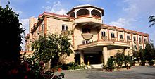 Mansingh palace
 Hotel Merwara estate
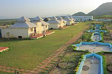 Tourist village, Pushkar
The hotels in Ajmer include
- Mansingh Palace
- Hotel Merwara State
- Hotel data inn
- Hotel Embassy
- Hotel Ambassador
- Hotel Prithviraj
- Hotel Heritage inn
- Hotel Omni Palace
- Hotel Sahil
- Regency Hotel and Restaurant
- Hotel Kanak Sagar
- RTDC Khadim Hotel (owned by Rajasthan government)
- Hotels in Pushkar include
- Pushkar Palace
- Jagat Singh Palace
- Gulaab Niwaas Palace
- Pushakar Bagh
- Green Park Resort
- Hotel Navaratan Palace
- RTDC Hotel Sarovar (owned by Rajasthan government)
- Teerth Palace
- Hotel Pushkar Lake Palace
Shopping and Eating
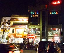 India motor circle
 Dominos pizza outlet
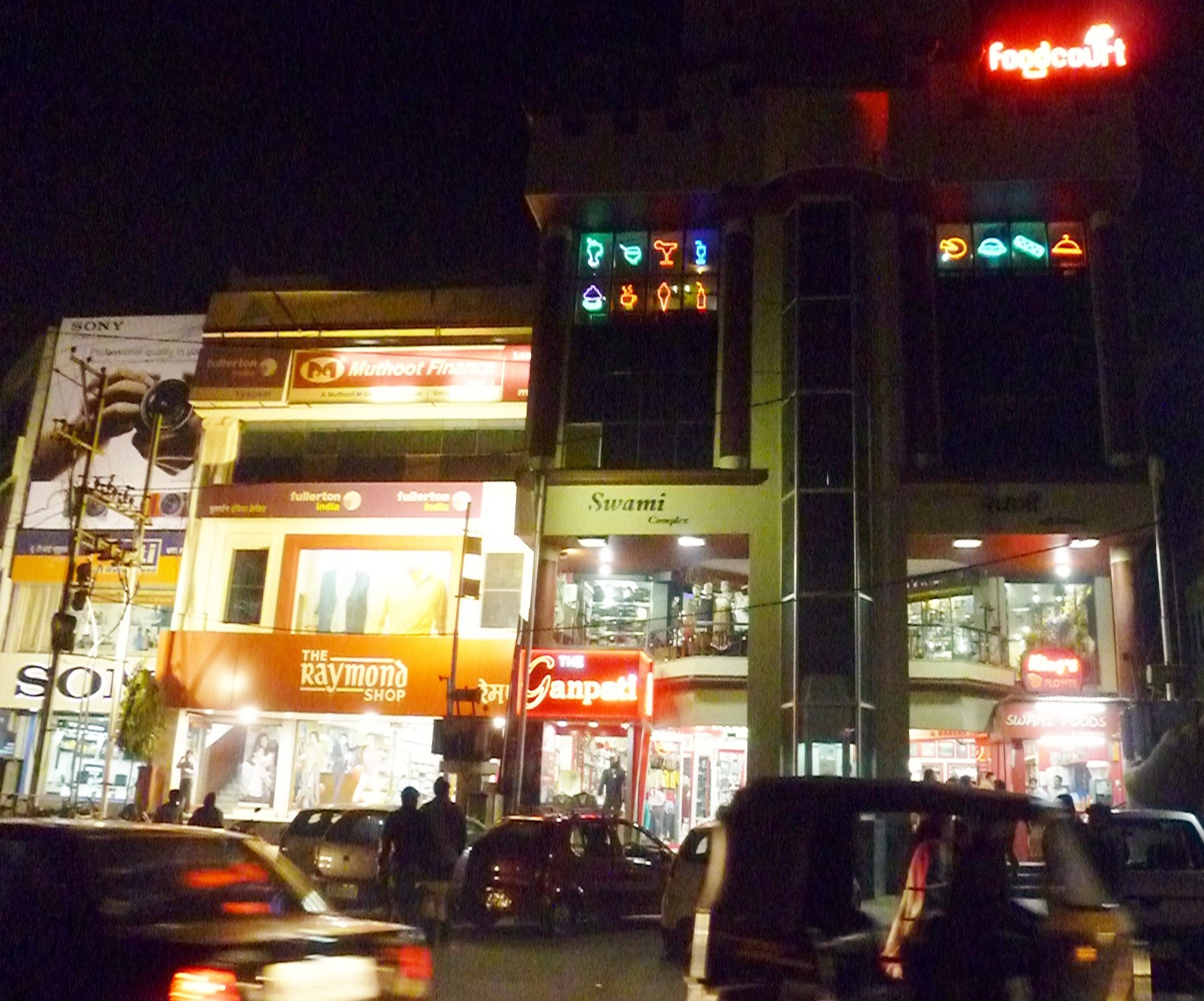
Madar Gate, Chudi Bazzar, Naya Bazzar, Dargah Bazzar, and Kesarganj are among the popular markets. Mahila Mandi (a women's market), closed on Tuesdays, carries Odnis (traditional veils, also used as light table covers), gorgeous saris, ornate Lehngas (skirts worn with blouses), Safas (hand tie-dyed turbans), and 9-metre long bands of local fabrics. Most of the malls and authorized retail outlets of leading brands are located on Jaipur Road, in Vaishali Nagar, and at India Motor Circle.
The city offers delectable sweets like Sohan Halwa and Jalebi, snacks (Chaat) like Aloo Tikki and Dahi Bada, and exotic sweets like Malpua of Pushkar, Kachoda of Nasirabad, Til Papdi of Beawar, and Makkhan Bada of Pahadia in Kishangarh. Ajmer also has fast food chains like Domino's and Pizza Hut.
Education
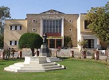 Government college Ajmer
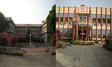 Sophia school and college
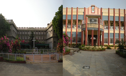
Ajmer is home to Mayo College, founded by the British Raj in 1875 to educate the children of Rajputana's nobles on the lines of an English public school. Ajmer is also home to the famous Sophia Girls' School (1918/1935) & College (1942), and the historic Ajmer Music College, founded in 1942, the first accredited institution in Rajputana for teaching Hindustani classical music. Other educational institutions that prominently shaped the academic environment of Ajmer before Independence are:[6]
- Govt. High School (1836/1861)
- Mission School (1862)
- Govt. College (1868)
- D.A.V. High School (1888/1918/1922)
- St. Mary's Convent (1896)
- Arya Putri Pathshala (1898)
- Chachiji's School (1898)
- Oswal Jain High School (1899/1929)
- Agrawal High School (1904/1932/1946)
- St. Anslem's High School (1904)
- Moinia Islamia High School (1910)
- Savitri High School (1914/1933)
- Saraswati Balika Vidyalaya (1924/1946)
- Govt. Central Girls' High School (1926/1945)
- Model School (1926)
- King George Royal Indian Military School (1930)
- School for the Blind (1935)
- Tikamchand School (1940)
- Virjanand School (1941)
- D.A.V. College (1942)
- Savitri College (1943)
The Board of Secondary Education for Rajasthan is located in Ajmer.
After 1947 some of the now famous schools were also established in Ajmer.
Demographics
 Panorama the Pushkar lake
 Ajmer as seen from Taragarh fort
As of 2011 India census,[7] Ajmer had population of 2,584,913 of which male and female were 1,325,911 and 1,259,002 respectively. In the education sector, Ajmer district have average literacy rate of 70.46 percent. Male literacy and female literacy were 83.93 and 56.42 percent respectively. In all, there were total 1,557,264 literates compared to 1,168,856 literates of 2001 census. Density of Ajmer district per square km is 305 compared to 257 per km2 of 2001. Sex ratio of girls in Ajmer per 1000 boys was recorded 950 i.e. an increase of 19 points from the figure of 2001 census, which puts it at 931. Population Growth for Ajmer district recorded in 2011 for the decade has remained 18.48 percent. Same figure for 1991-2001 decade was 20.93 percent.
See also
References
- ^ http://books.google.co.in/books?ei=npaJTf3XI4LTrQf8_9XNDg&ct=result&id=mqYIAAAAQAAJ&dq=ahirs+of+ajmer&q=52
- ^ The Rajputana gazetteers-page-34
- ^ News India Times, New York NY, USA, April 25, 2008.
- ^ Arhai-din-ka Jhompra Mosque archnet.org.
- ^ Main Building Architecture: Official website of Mayo College, Ajmer, India
- ^ Ajmer Itihas Aur Paryatan, Shiv Sharma, publisher: Shabda Sadhana, Ajmer, India, 2009, ISBN-81-89454-19-6.
- ^ "Census of India 2001: Data from the 2001 Census, including cities, villages and towns (Provisional)". Census Commission of India. Archived from the original on 2004-06-16. http://web.archive.org/web/20040616075334/http://www.censusindia.net/results/town.php?stad=A&state5=999. Retrieved 2008-11-01.
 This article incorporates text from a publication now in the public domain: Chisholm, Hugh, ed (1911). Encyclopædia Britannica (11th ed.). Cambridge University Press.
- W.D. Begg: The Holy Biography of Hazrat Khwaja Muinuddin Chishti (Millat Book Centre, Delhi, 1999).
- Ajmer The Imperial Gazetteer of India, 1909, v. 5, p. 137-146.
External links
Ajmer Ajmer · Kekri · Kiranipura · Kishangarh · Nasirabad · Pushkar · Sarwar · Vijainagar
Cities and towns
in other districtsAlwar · Banswara · Baran · Barmer · Beawar · Bharatpur · Bhilwara · Bikaner · Bundi · Chittorgarh · Churu · Dausa · Dholpur · Dungarpur · Hanumangarh · Jaipur · Jaisalmer · Jalore · Jhalawar · Jhunjhunu · Jodhpur · Karauli · Kota · Nagaur · Pali · Pratapgarh · Rajsamand · Sawai Madhopur · Sikar · Sirohi · Sri Ganganagar · Tonk · Udaipur
State of Rajasthan (India) Major cities 
Divisions Districts Ajmer · Alwar · Banswara · Baran · Barmer · Bharatpur · Bhilwara · Bikaner · Bundi · Chittorgarh · Churu · Dausa · Dholpur · Dungarpur · Hanumangarh · Jaipur · Jaisalmer · Jalore · Jhalawar · Jhunjhunu · Jodhpur · Karauli · Kota · Nagaur · Pali · Pratapgarh · Rajsamand · Sawai Madhopur · Sikar · Sirohi · Sri Ganganagar · Tonk · UdaipurCategories:- Ajmer
- Cities and towns in Ajmer district
- Railway stations in Rajasthan
- Ajmer railway division
- Divisions of Indian Railways
- North Western Railway Zone
- Holy cities


Wikimedia Foundation. 2010.