- Churu district
-
This article is about the district. For its eponymous headquarters, see Churu.
 Churu District in Rajasthan
Churu is a district of Rajasthan state of western India. The town of Churu is the administrative headquarters of the district.
Churu lies in the Jangladesh region of northern Rajasthan. Churu lies in 28° 18' N latitude and 74° 58' E longitude. It is bounded by Hanumangarh District to the north, Haryana state to the east, Jhunjhunun and Sikar districts to the southeast, Nagaur District to the south, and Bikaner District to the west.
The district has an area 16,830 km², with a road length of 1901 km. The population is 1,922,908. The sex ratio is 948 females per thousand males and literacy percentage is 66.97%. There are 6 tehsils in the district, namely - Churu, Ratangarh, Taranagar, Rajgarh, Sardarshahar, and Sujangarh. The major crops are bajra and gram. The major minerals found in the district are copper and gypsum.
 a view of desert of churu
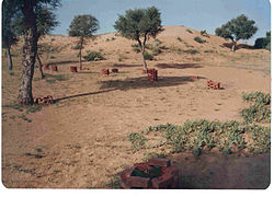 view of desert of churu
Contents
District Officials
Positions Name of official Service Serving since Police Superintendent Nisar Ahmed Faruki IPS March 2009 Collector/Magistrate Vikas Sitaram Bhale IAS (Indian Administrative Service) February 2009 Collector/Magistrate | KK Pathak | IAS (Indian Administrative Service) | October 2010
Visitor attractions
Sujangarh, Ratangarh, Sardarshahar, Tarangar, Rajgarh, Ratannagar, Chapper, Bidasar and Rajaldesar are the other major towns in the district. Tal Chhapar Sanctuary, blackbuck sanctuary, having more than 1680 black bucks and migratory birds, is the major attraction for wild life enthusiasts. The other attractions are grand palatial Havelies in Ratannagar, Ratangarh and Sardarshahar towns, the Hanuman temple at Salasar, the Venkateshwar temple at Sujangarh, the birth place of local deity Goga Pir in Dadrewa and the Gurudwara in Sahawa. a recently made Ichchhapurna Balaji Temple at Sardarshahar. Bhadrakali Temple at Rajaldesar is popular among Shakta Tantra followers of all over India, it is established by Anant Shri Vibhushit Dandi Swami Jogendrashram ji Maharaj.
Demographics
According to the 2011 census Churu district has a population of 2,041,172,[1] roughly equal to the nation of Botswana[2] or the US state of New Mexico.[3] This gives it a ranking of 224th in India (out of a total of 640).[1] The district has a population density of 148 inhabitants per square kilometre (380 /sq mi) .[1] Its population growth rate over the decade 2001-2011 was 6.1 %.[1] Churu has a sex ratio of 938 females for every 1000 males,[1] and a literacy rate of 67.46 %.[1]
Human Resources
- Population: 19,22,908
- Density of population (persons/km²): 114
- Literacy: 66.97%
- Working Population (per cent of total population): 29.50%
Percentage distribution of work force
- Cultivators: 73.17%
- Agricultural labourers: 3.16%
Household, Industry, and Manufacturing
- Processing, servicing, and repairs: 2.26%
- Other workers: 21.41%
Major Crops and their Production
1999-2000 (tonnes)
- Bajra: 27
- Wheat: 60,654
- Rapeseed and Mustard: 24,705
- Pulses: 9,594
- Gram: 316
- Moong
- Moth
- Guar
- Til
Communication Facilities
- Post offices: 392
- Telegraph offices: 89
- Telephone exchanges: 83
- Public call offices: 682
Educational Facilities/Institutions
- Primary and middle schools: 1472
- Secondary and higher secondary schools: 207
- ITIs: 3
- Post graduate and under graduate: 11
- 14 Private BED College & 01 Govt BED College
Industrial Scenario
- No. of Large and Medium Scale Units: 2
- No. of Small Scale Units: 3,963
- No. of Industrial Areas: 6
Infrastructure
Electricity
Power supply to the district is from Bhakra Hydel Complex through 132 kV lines coming via Hissar in Haryana. Of the total 926 villages in the district, 902 villages have been electrified.
Water
Water is available at the depth of 30 to 48 m except in some places viz. Sujangarh and taranagar tehsils.
Road Transport
The district has good connections within and outside the State. National Highway No.11 (Agra-Bikaner) passes through the district. The total length of roads in the district is 3,010 km and is in Delhi.
Rail transport
Churu district is served by meter gauge lines of the Northern Railway (India) and the Western Railway (India). Total length of rail line is 363 km.Now the broad gauge is also developing in some areas.
Air Transport
Nearest airport is at Jaipur (205 km).
Main Industries
Aluminium utensils, Blanket Weaving, Cement, Churan and Chatni, Guargum, Handicraft items on Sandal Wood, Handloom Cloth, Iron and Steel Fabrication, Oil Mills, Papad and Mangori, Polythene Films and Bags, Salt, Sand Lime bricks, Steel Furniture, Toilet and Washing Soap.
Famous Personalities of Churu District
- Lakshmi Mittal - the "Steel King" was born at Sadulpur in Churu District
- Gaurav Sharma- A world famous Mountaineer & Adventurist, who successfully climbed Mount Everest on 20 May 2009.
- Bimal Jain- Former RBI Governorn
- Bharat Vyas - He is the writer of the immortal prayer song, ‘Ae Malik Tere Bande Hum’ and 'ye kaun chitrakar hai'. He also directed a Bollywood film of Rangeela Rajasthani.
- Devendra Jhajharia - India's first ever gold medalist at the Paralympics
- Narendra Budania - Member of Parliament.
- Ram Singh Kaswan - Member of Parliament.
- Kanhaiya Lal Sethia- Eminent Rajasthani Writer.
- Arun Sharma- President of N.s.u.i Taranagar.
- Thakur Dal Singh - Eminent Administrator and Philanthropist.
- Hanuman Prasad Pooder - World Famous Geeta Prees
- Durga Prasad pandiya - social worker and Former Presidents of delhi pareek sabha was born at Pulsar near Sardarshahar in Churu District.
- Mangilal meghwal - from vill.sikarali(ratangarh)honoured vishav karma rashtriy puruskar 1998 & prime minister`s shram shri award 2003.
See also
- Churu (Lok Sabha constituency)
- Churu
- Ratangarh
- Ratannagar
- Sadulpur
- Sardarshahar
- Bidasar
- Sujangarh
- Sandwa
- Tal Chhapar Sanctuary
- Rajaldesar
References
- ^ a b c d e f "District Census 2011". Census2011.co.in. 2011. http://www.census2011.co.in/district.php. Retrieved 2011-09-30.
- ^ US Directorate of Intelligence. "Country Comparison:Population". https://www.cia.gov/library/publications/the-world-factbook/rankorder/2119rank.html. Retrieved 2011-10-01. "Botswana 2,065,398"
- ^ "2010 Resident Population Data". U. S. Census Bureau. http://2010.census.gov/2010census/data/apportionment-pop-text.php. Retrieved 2011-09-30. "New Mexico - 2,059,179"
External links

Hanumangarh district Bikaner district 
Bhiwani district, Haryana  Churu district

Nagaur district Sikar district Jhunjhunun district Cities and towns
in other districtsAjmer · Alwar · Banswara · Baran · Barmer · Bharatpur · Bhilwara · Bikaner · Bundi · Chittorgarh · Dausa · Dholpur · Dungarpur · Hanumangarh · Jaipur · Jaisalmer · Jalore · Jhalawar · Jhunjhunu · Jodhpur · Karauli · Kota · Nagaur · Pali · Pratapgarh · Rajsamand · Sawai Madhopur · Sikar · Sirohi · Sri Ganganagar · Tonk · Udaipur
State of Rajasthan (India) Rajasthan Topics Major cities 
Divisions Districts Ajmer · Alwar · Banswara · Baran · Barmer · Bharatpur · Bhilwara · Bikaner · Bundi · Chittorgarh · Churu · Dausa · Dholpur · Dungarpur · Hanumangarh · Jaipur · Jaisalmer · Jalore · Jhalawar · Jhunjhunu · Jodhpur · Karauli · Kota · Nagaur · Pali · Pratapgarh · Rajsamand · Sawai Madhopur · Sikar · Sirohi · Sri Ganganagar · Tonk · UdaipurHindu Temples in Rajasthan Ajmer Brahma Temple at Pushkar
Banswara Barmer Bikaner Bhilwara Chittorgarh Kalika Mata Temple, Chittorgarh Fort • Khudala Temple • Sanwaliaji Temple
Churu Dausa Hanumangarh Jaipur Birla Mandir, Jaipur • Galtaji • Govind Dev Ji Temple • Panchayati Hall • Shila Devi
Jaisalmer Jalor Jhunjhunu Rani Sati Temple
Jodhpur Latiyal Mata Temple
Karauli Nagaur Dadhimati Mata Temple • Kunjal Mata Temple
Pali Nimbo Ka Nath Mahadev Temple • Parshuram Mahadev Temple • Sai Dham Rani Rajasthan • Sonana Khetlaji
Rajsamand Sikar Jeenmata • Raghunathji
Tonk Shri Devnarayan temple
Categories:


Wikimedia Foundation. 2010.