- Mandsaur
-
This article is about the municipality in Madhya Pradesh, India. For its namesake district, see Mandsaur District.
Mandsaur — city — Coordinates 24°02′N 75°05′E / 24.03°N 75.08°ECoordinates: 24°02′N 75°05′E / 24.03°N 75.08°E Country India State Madhya Pradesh District(s) Mandsaur Mayor Time zone IST (UTC+05:30) Website www.mandsaur.nic.in Mandsaur or Mandsour (Hindi:मन्दसौर/मंदसौर) is a city in the Malwa region and district of Madhya Pradesh state of central India. It is the administrative headquarters of Mandsaur District.
Contents
Origin of name
The name Mandsaur evolved from Marhsaur, which originated from Marh and Saur (or Dasaur), two of the villages which merged in the town.[citation needed]The town was known as Dashapura in ancient times. The area was ruled by Dasharna people during Mahabharata period. It is probably Dasharna janapada which gave name Dashpur to the Mandsaur town.
History
Mahabharata period
The Mahabharata Book 2: Sabha Parva SECTION XXXI locates Trigartas along with Dasharnas, the Sivis, the Amvashtas, the Malavas, the five tribes of the Karnatas around Rohtak in Haryana as under:
- Vaisampayana said,--"I shall now recite to you the deeds and triumphs of Nakula, and how that exalted one conquered the direction that had once been subjugated by Vasudeva. The intelligent Nakula, surrounded by a large host, set out from Khandavaprastha for the west, making this earth tremble with the shouts and the leonine roars of the warriors and the deep rattle of chariot wheels. The hero first assailed the mountainous country called Rohitaka that was dear unto (the celestial generalissimo) Kartikeya and which was delightful and prosperous and full of kine and every kind of wealth and produce. The encounter the son of Pandu had with the Mattamyurakas of that country was fierce. And the illustrious Nakula after this, subjugated the whole of the desert country and the region known as Sairishaka full of plenty, as also that other one called Mahetta. And the hero had a fierce encounter with the royal sage Akrosa. The son of Pandu left that part of the country having subjugated the Dasarnas, the Sivis, the Trigartas, the Amvashtas, the Malavas, the five tribes of the Karnatas, and those twice born classes that were called the Madhyamakeyas and Vattadhanas. Making circuitous journey that bull among men then conquered the (Mlechcha) tribes called the Utsava-sanketas."
Aulikaras of Dashapura
Epigraphical discoveries have brought to light two ancient royal houses, who call themselves as Aulikaras and ruled from Dashapura (present-day Mandsaur). The first dynasty, who ruled from Dashapura from the beginning comprised the following kings in the order of succession: Jayavarma, Simhavarma, Naravarma, Vishvavarma and Bandhuvarma. Bandhuvarma was contemporary of Kumaragupta I. There is an inscription about Bandhuvarma at Mandsaur. The silk workers had constructed a Sun temple here which was repaired by Bandhuvarma in Samvat 493 (436 CE). This indicates that he was present there till 436 CE. The Risthal stone slab inscription discovered in 1983 has brought to light another Aulikara dynasty, which comprised the following kings in the order of succession: Drumavardhana, Jayavardhana Ajitavardhana, Vibhishanavardhana, Rajyavardhana and Prakashadharma. After Parakshadharma, the ruler of Mandsaur was Yashodharma, who is identified with Vishnuvardhana, who erected a pillar of victory at Bayana due to which Bayana’s name became Vijaygarh. In all probabilities, he was the son and immediate successor of Prakashadharma.[1] Yashodharma Vishnuvardhana assumed the title of Samrat after he occupied the territories of Bandhuvarma. It is also mentioned that Yashodharma Vishnuvardhana had assumed the title of ‘Maharajadhiraja’ or Emperor.[2]
Yashodharman rule
 Victory pillar of Yashodharman at Sondani, Mandsaur
 Info of Victory pillar of Yashodharman at Sondani, MandsaurMain article: Yashodharman
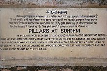
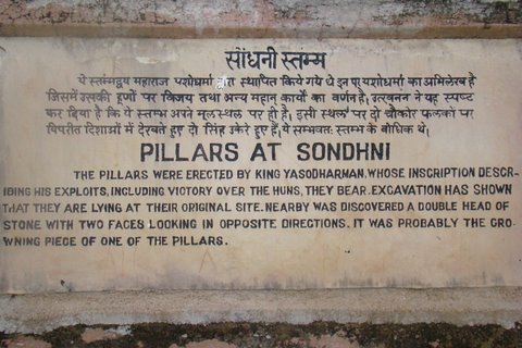
Sondani (सोंधनी) is a small village at a distance of about 4 km from Mandsaur situated on Mahu-Nimach National Highway towards Mahu. Two monolith pillars were erected here by King Yasodharman in 528 AD with inscription which describe his exploits including victory over Hunas.,[3][4] Excavations by the Indian Archaeology Department show that these pillars are lying at their original site. Nearby was discovered a double head of stone with two faces of lions looking in opposite directions. It was probably the crowning piece of one of the pillars.
Each pillar is of height 40 feet, girth 3.5 feet and weighs 200 ton.,[3][5] The inscription bears verses composed by the poet Vasula, the son of Kakka. This eulogy has been engraved by Govinda. The composition is in Sanskrit language and script is north Indian brahmi.,[6][7] Nagappa and Dasappa were two south Indian artisans who gave shape to these pillars. These pillars were discovered by British officer Sulvin in 1875. John F. Fleet discovered their other pieces. In 1921 Shri V.S. Garde, Director Archaeology Gwalior state, made a terrace and put these pillars over it.[6]
Gurjara-Pratihara Dynasty
Main article: Mahendrapala IIThe Gurjara Pratihara empire was extended up to Mandasor during the reign of Mahendrapala II.[8]
Dilawar Khan Ghauri
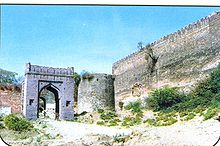
The Mandsaur city is situated on the border of Malwa and Mewar and as such is strategically very important. After the attack of Timur, the Delhi Sultanate became weak. Dilawar Khan Ghauri was governor of the Malwa province of central India during the decline of the Delhi Sultanate. Dilawar Khan declared himself Sultan of Malwa in 1401, and passed the kingdom to his son Hoshang Shah upon his death. Thus he had practically come to Mandu in 1401 as the first King of Malwa. Dilawar had also shifted the capital from Dhar to Mandu, renaming it Shadiabad, the city of joy. The successor of Dilawar Khan Gauri was Hushang Shah Gori (1405–1435), who constructed fort at strategically important Mandsaur city to strengthen his north-west boundary.[9]
In 1519 Rana Sanga occupied the fort and appointed Ashokmal Rajput as its Kiledar. In 1535 Humayun also stayed here for few months during his Malwa expedition. During Sher Shah period Sadar Khan was appointed its Kiledar.[10] During the reign of Akbar Mandsaur got the status of sarkar. In 1733 the Malwa subedar of Mughals Sawai Jaisingh attacked the fort but was defeated by Marathas and the fort went to Marathas.[11] The historically most important event in the fort was the treaty of 1818 between Tantiya Jog senapati of Malhar Rao Holkar II and Sir John Malcum under which Malwa came in occupation of British rule.[12][13] There are two gardens in which there is a pillar of torandwar. It is believed to be pillar of Surya Mandir of the inscription of Bandhu Varma. There is a Shiva statue also in the garden.[13]
Hinglajgarh Fort
Main article: Hinglajgarh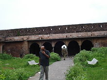 Hinglaj Fort Darbar Hall
Hinglajgarh (हिंगलाजगढ़) or Hinglaj Fort is an ancient fort situated near village Navali in Bhanpura tehsil of Mandsaur district in Madhya Pradesh. Its coordinates are Latitude 25°30' N and Longitude 65°31' E. It is situated at a distance of 165 km from Mandsaur town and 26 km from Bhanpura town in Madhya Pradesh.[14] This fort has been at its peak of grandeur during Parmara rule.[15] There are many artistic sculptures of various periods in this fort. The Nandi and Uma-Maheshwar sculptures were sent from here to France and Washington for display in India festivals and left a mark at International levels.[16] The Hinglajgarh had been centre of excellence in craftmanship of sculptures for about 800 years. The statues recovered from this fort are from Guptas period to Parmara period. The most ancient statues are from 4-5th century AD.[17]
Princely State
In 19th century before India's independence in 1947, Madsaur was part of the princely state of Gwalior. It gave its name to the treaty with the Holkar Maharaja of Indore, which concluded the Third Anglo-Maratha War and the Pindari War in 1818. At the turn of the 20th century it was a centre of the Malwa opium trade.
Geography
Mandsaur District forms the northern projection of Madhya Pradesh from its western Division, i.e.,Ujjain Commissioner's Division. It lies between the parallels of latitude 230 45' 50" North and 250 2' 55" North, and between the meridians of longitude 740 42' 30" East and 750 50' 20" East.
The District is an average size district of Madhya Pradesh. It extends for about 142 km. from north to south and 124 km. from east to west. The total area is 5521 km² with a population of 116483 in 2001.
Demographics
As of 2001[update] India census,[18] Mandsaur had a population of 116,483. Males constitute 52% of the population and females 48%. Mandsaur has an average literacy rate of 71%, higher than the national average of 59.5%: male literacy is 78%, and female literacy is 64%. In Mandsaur, 13% of the population is under 6 years of age.
Transport
- Road: Mandsaur is situated on Ajmer-Lebad(Indore) NH-79 as well as Mhow-Neemuch SH-31 (soon becoming 4 Lane).
- Rail: Mandsaur is situated on Ajmer-Akola track of Indian Railways and is under Ratlam rail division of WR. Currently there are 6 trains available from Mandsaur. Mandsaur has direct trains for Mumbai, Ajmer, Udaipur, Agra, Kota, Indore, Ujjain, Ratlam.
The major trains passing from Mandsaur are:-
- Ajmer/Udaipur-Bandra Terminus SF Express
- Indore-Udaipur Express
- Ratlam-Ajmer Express (Night)
- Ratlam-Ajmer Express
- Ratlam-Chittaurgarh Express
- Ratlam-Agra Fort Express
- Local: Auto and Tempo are main source of local transport in Mandsaur
Tourism
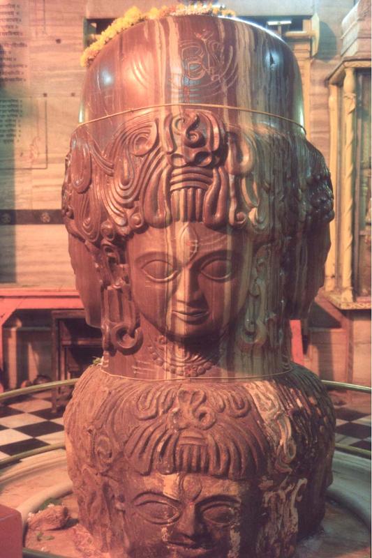
 Idol of Lord Pashupatinath in Mandsaur.
Mandsaur and its neighborhood are full of places of tourist interest. An inscription discovered near the town indicated the erection of a temple of the sun in 437, and at Sondani are two great monolith pillars recording a victory of Yasodharman, king of Malwa, in 528. The fort dates from the 14th and 15th centuries. Hindu and Jain remains are numerous, though the town is predominantly Muslim.
Mandsaur is also famous for Pashupatinath Temple, a Hindu temple situated on the banks of the Shivana river. Pashupatinath Temple is one of the prominent shrines in Mandsaur of Madhya Pradesh. Lord Shiva in the form of Lord Pashupatinath is the principal deity here. The highlight is a unique Shivling with eight faces of Lord Shiva[1]. The shrine has four doors in four directions.
Taxakeshwar temple
Main article: Taxakeshwar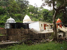 Taxakeshwar temple
Taxakeshawar (तक्षकेश्वर) or Takhaji (ताखाजी) is a place of religious and historical importance in Mandsaur district in Madhya Pradesh. It is situated at a distance of 22 km from Bhanpura town on Hinglajgarh road.[19] This is the site of serpent king taxak, where he is worshiped as Taxakeshawar but the local people call him Takhaji. Curiously enough he shares the worship of the country folk with Dhanvantri, the Indian Aesculapius.[20][21] The shrine in question stands on a most romantic spot from village Navali[22] situated on the table land at the foot of which Bhanpura lies.[20]
Gandhi Sagar Sanctuary
-
Main article: Gandhi Sagar Sanctuary
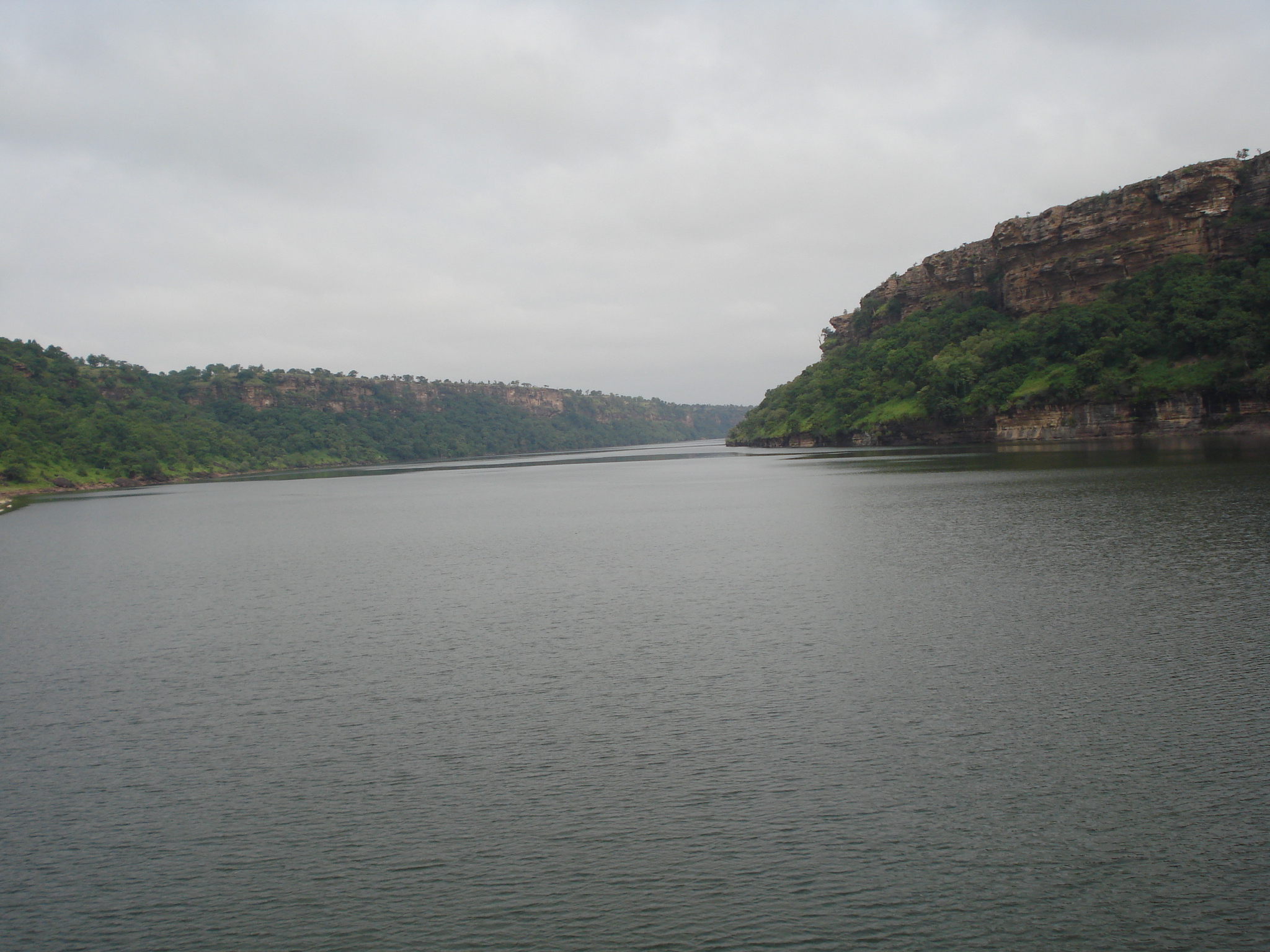
 River Chambal in Gandhi Sagar Sanctuary
Gandhi Sagar Sanctuary is wildlife sanctuary situated on the northern boundary of Mandsaur and Nimach districts in Madhya Pradesh, India. It is spread over an area of 368.62 km squire adjoining Rajasthan state in India. It was notified in 1974 and more area was added in 1983. The Chambal River passes through the sanctuary and divides into two parts. The western part is in Nimach district and eastern part is in Mandsaur district.
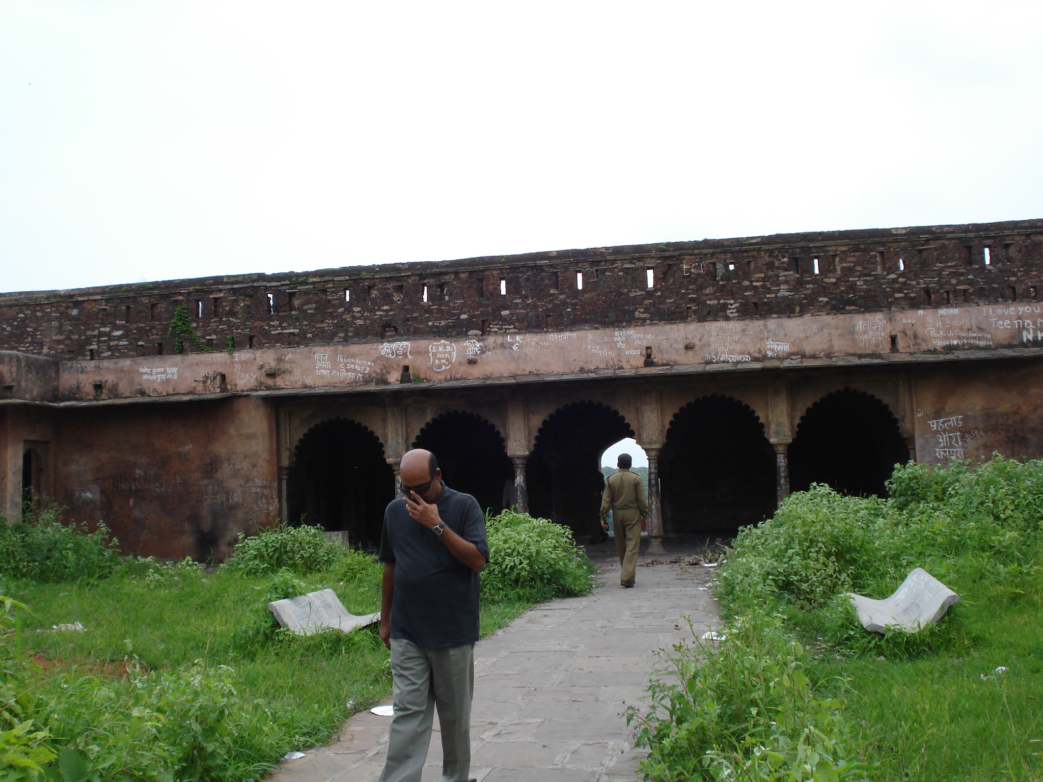
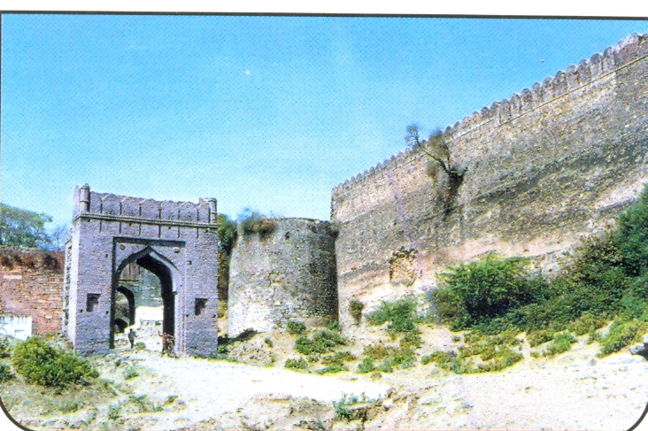
Mandsaur Fort
-
Main article: Mandsaur Fort
 Mandsaur or Dashpur Fort
Mandsaur Fort, also known as Dashpur Fort, is situated in Mandsaur city in Mandsaur district in Madhya Pradesh state of India.[23] The Mandsaur city is situated on the border of Malwa and Mewar and as such is strategically very important. After the attack of Timur, the Delhi Sultanate became weak. Dilawar Khan Ghauri was governor of the Malwa province of central India during the decline of the Delhi Sultanate. Dilawar Khan declared himself Sultan of Malwa in 1401, and passed the kingdom to his son Hoshang Shah upon his death. Thus he had practically come to Mandu in 1401 as the first King of Malwa. Dilawar had also shifted the capital from Dhar to Mandu, renaming it Shadiabad, the city of joy. The successor of Dilawar Khan Gauri was Hushang Shah Gori (1405–1435), who constructed fort at strategically important Mandsaur city to strengthen his north-west boundary.[9] He is also remembered for his wonderful taste in architecture.
Bandi Ji Ka Baag: A Temple with Glass interiors. Bandi Ji Ka Baag is a 120 Yrs old Jain temple with interiors done with Glass. A worth visit place. It is very near to Main Bus Stand. The temple currently has a "Maan Stambh", built when temple celebrated 100 years of establishment.
Important Institutions in Mandsaur
- School:
- Mandsaur International School
- St. Thomas Convent School (http://www.stthomasschool.co.in/)
- Dashpur Vidhya Mandir
- Vatsalya public School
- Central School
- Dashpur Vidyalaya
- Saraswati Shishu mandir,Keshav Nagar
- Saraswati Vidya Mandir,Sanjeet Marg
- National English School
- Subhash English school
- Bhartiya Vidhya Mandir, Choudhary Colony
- Jhalani Mahila Vidyapeeth.
- Engineering College: Mandsaur Institute of Technology
- Pharmacy Colleges:
- B.R.Nahata College of Pharmacy (http://www.brncop.org/).
- Mandsaur Institute of Pharmacy.
- Law college: JL Nehru Law College.
References
- ^ Agarwal, Ashvini (1989). Rise and Fall of the Imperial Guptas, Delhi:Motilal Banrasidass, ISBN 81-208-0592-5, pp.250-6
- ^ Thakur Deshraj: Jat Itihas (Hindi), Maharaja Suraj Mal Smarak Shiksha Sansthan, Delhi, 1934, p. 710
- ^ a b Usha Agarwal:Mandsaur Zile Ke Puratatvik samarakon ki paryatan ki drishti se sansadhaniyata - Ek Adhyayan, Chirag Prakashan Udaipur, 2007, p. 19
- ^ Mangal Mehta (Ed): Dashpur Janapada aur sanskriti, p. 142
- ^ H.Michael Brown (Ed): Gwalior Today, p. 180
- ^ a b Usha Agarwal:Mandsaur Zile Ke Puratatvik samarakon ki paryatan ki drishti se sansadhaniyata - Ek Adhyayan, Chirag Prakashan Udaipur, 2007, p. 20
- ^ Sriram Goyal:Guptakalin Abhilekh, p. 366
- ^ Rama Shankar Tripathi (1989). History of Kanauj: To the Moslem Conquest. Motilal Banarsidass Publ.. p. 269. ISBN 812080404X, ISBN 9788120804043. http://books.google.co.in/books?id=2Tnh2QjGhMQC&pg=PA269&dq.
- ^ a b Sikandar bin Mahmud:Mirat-e-Sikandar, p. 113
- ^ H.Mikal Brown (Ed): Gwalior Today, 180
- ^ Raghuvir Singh:Madhyakalin Mandsaur mien huee Bharatiy Itihas ki kuchh nirnayak ghatnaen, p. 12
- ^ Mandsaur district gazetteer, p. 42
- ^ a b Usha Agarwal:Mandsaur Zile ke Puratatvik samarakon ki paryatan ki drishti se sansadhaniyata - Ek Adhyayan, Chrag Prakashan Udaipur, 2007, p. 19
- ^ Rajendra Verma:Mandsaur District Gazetteer, p. 289
- ^ Ramlal Kanwal:Prachin Malwa mein Vastukala, p. 185
- ^ Usha Agarwal:Mandsaur Zile Ke Puratatvik samarakon ki paryatan ki drishti se sansadhaniyata - Ek Adhyayan, Chirag Prakashan Udaipur, 2007, p. 38
- ^ Usha Agarwal:Mandsaur Zile Ke Puratatvik samarakon ki paryatan ki drishti se sansadhaniyata - Ek Adhyayan, Chirag Prakashan Udaipur, 2007, p. 42
- ^ "Census of India 2001: Data from the 2001 Census, including cities, villages and towns (Provisional)". Census Commission of India. Archived from the original on 2004-06-16. http://web.archive.org/web/20040616075334/http://www.censusindia.net/results/town.php?stad=A&state5=999. Retrieved 2008-11-01.
- ^ Usha Agarwal:Mandsaur Zile Ke Puratatvik samarakon ki paryatan ki drishti se sansadhaniyata - Ek Adhyayan, Chirag Prakashan Udaipur, 2007, p. 35
- ^ J.P.H. Vogel:Indian Serpent lore, p.206
- ^ http://www.fallingrain.com/world/IN/0/Navali.html
- ^ Usha Agarwal:Mandsaur Zile ke Puratatvik samarakon ki paryatan ki drishti se sansadhaniyata - Ek Adhyayan, Chrag Prakashan Udaipur, 2007, p. 18
 This article incorporates text from a publication now in the public domain: Chisholm, Hugh, ed (1911). Encyclopædia Britannica (11th ed.). Cambridge University Press.
External links
Cities and towns in Ujjain Division Dewas district Mandsaur district Neemuch district Ratlam district Shajapur district Agar · Akodia · Badagoan · Badod · Kanad · Maksi · Polay Kalan · Shajapur · Shujalpur · Soyatkalan · SusnerUjjain district Related topics Cities and towns
in other DivisionsCategories:- Cities and towns in Mandi district
- Cities in Malwa
- Mandsaur
- Railway stations in Madhya Pradesh
- Former Indian capital cities


Wikimedia Foundation. 2010.