- National Highway 212 (India)
-
National Highway 212

212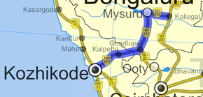
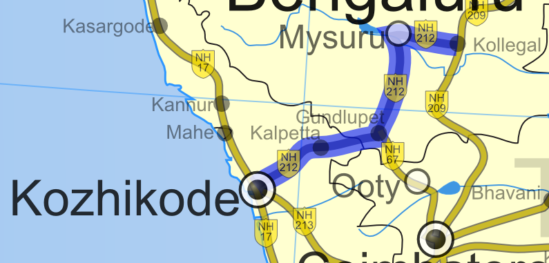
Route information Length: 272 km (169 mi) Major junctions From: Kozhikode To: Kollegal Location States: Karnataka: 155 km
Kerala:117 kmPrimary
destinations:Kozhikode - Kalpetta -Sultan Battery- Gundlupet - Mysore - Kollegal Highway system Indian Road Network
National • Expressways • State
State Highways in ¬← NH 211 NH 213 → National Highway 212 (NH 212) is a National Highway in Southern India. NH 212 connects Kozhikode in Kerala with Kollegal in Karnataka via Mysore. Of the total distance of 250 km, 90 km is in Kerala and 160 is in Karnataka. At Kollegala, it joins National Highway 209, which connects Bengaluru and Dindigal.[1] At Gundlupete in Chamarajanagar district of Karnataka, NH-67 also touches NH-212.
The highway passes through dense forests of Western ghats of India. The NH-212 passes through Bandipur National Park and other reserve forests. The rapid rise in traffic of vehicles (Automobiles) in this highway has led to deaths of wild animals due to the speeding traffic, even though vehicles are not allowed from 9 P.M to 6 A.M in some stretches.[2]
Contents
Route
In Kerala
- Junction in Malaparamb NH 17 bye pass
- kunnamangalam
- Koduvally
- Thamarassery
- Vythiri
- Kalpetta
- Sultan Battery
- Muthanga
In Karnataka
See also
References
External links
Indian Highways Network National Expressways 


State Expressways Mumbai-Pune • Delhi-Gurgaon • DND Flyway • Bengaluru-Mysore • Chennai HSCTC • Hyderabad Elevated ExpresswaysNational Highways 1 • 1A • 1B • 1C • 1D • 2 • 2A • 3 • 4 • 4A • 4B • 5 • 5A • 6 • 7 • 7A • 8 • 8A • 8B • 8C • 8D • 8E • 9 • 10 • 11 • 11A • 11B • 12 • 12A • 13 • 14 • 15 • 16 • 17 • 17A • 17B • 18 • 19 • 20 • 21 • 21A • 22 • 23 • 24 • 24A • 24B • 25 • 25A • 26 • 26A • 27 • 28 • 28A • 28B • 28C • 29 • 30 • 30A • 31 • 31A • 31B • 31C • 31D • 32 • 33 • 34 • 35 • 36 • 37 • 37A • 38 • 39 • 40 • 41 • 42 • 43 • 44 • 44A • 45 • 45A • 45B • 45C • 46 • 47 • 47A • 47B • 47C • 48 • 49 • 50 • 51 • 52 • 52A • 52B • 53 • 54 • 54A • 55 • 56 • 57 • 57A • 58 • 59 • 59A • 60 • 60A • 61 • 62 • 63 • 64 • 65 • 66 • 67 • 68 • 69 • 70 • 71 • 71A • 71B • 72 • 72A • 73 • 73A • 74 • 75 • 76 • 77 • 78 • 79 • 79A • 80 • 81 • 82 • 83 • 84 • 85 • 86 • 86A • 87 • 88 • 89 • 90 • 91 • 91A • 92 • 93 • 94 • 95 • 96 • 97 • 98 • 99 • 100 • 101 • 102 • 103 • 104 • 105 • 106 • 107 • 108 • 109 • 110 • 111 • 112 • 113 • 114 • 116 • 117 • 119 • 121 • 123 • 125 • 126 • 127 • 128 • 129 • 150 • 151 • 152 • 153 • 154 • 155 • 200 • 201 • 202 • 203 • 203A • 204 • 205 • 206 • 207 • 208 • 209 • 210 • 211 • 212 • 213 • 214 • 214A • 215 • 216 • 217 • 218 • 219 • 220 • 221 • 222 • 223 • 224 • 226 • 227 • 228 • 229 • 234 • 235State Highways Andhra Pradesh • Arunachal Pradesh • Assam • Bihar • Chhattisgarh • Goa • Gujarat • Haryana • Himachal Pradesh • Jammu and Kashmir • Jharkhand • Karnataka • Kerala • Madhya Pradesh • Maharashtra • Manipur • Meghalaya • Mizoram • Nagaland • Orissa • Punjab • Rajasthan • Sikkim • Tamil Nadu • Tripura • Uttarakhand • Uttar Pradesh • West BengalNotable Categories:- National Highways in Karnataka
- National Highways in Kerala
- Indian National Highways
- India road stubs


Wikimedia Foundation. 2010.