- National Highway 50 (India)
-
National Highway 50

50
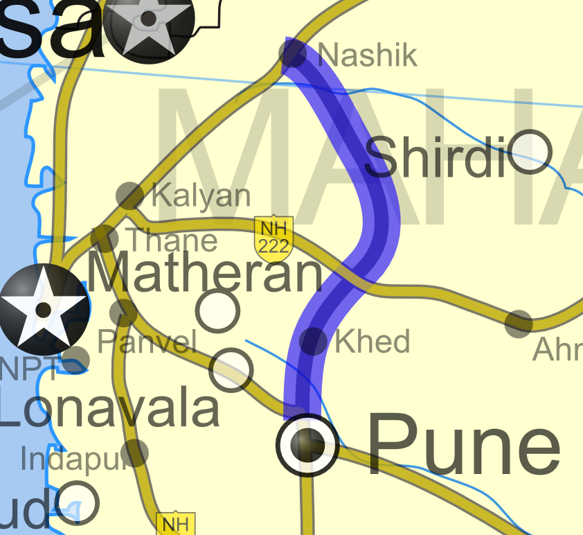
Road map of India with National Highway 50 highlighted in solid red colorRoute information Length: 192 km (119 mi) Major junctions North end: Nashik, Maharashtra NH 3 in Nashik
NH 9 near Pune (via NH 4)
NH 4 near Pune
NH 222 near AleSouth end: Pune, Maharashtra Location States: Maharashtra Primary
destinations:Nashik - Sangamner - Narayangaon - Pune Highway system Indian Road Network
National • Expressways • State
State Highways in ¬← NH 49 NH 51 → National Highway 50, or NH 50, is a National Highway in India that runs completely within the state of Maharashtra. The highway connects the cities of Nasik, Sangamner, Narayangaon, Khed and Pune. The road is part of the National Highway network of India, and it is officially listed as running over 192 km (119 mi) from Nasik to Pune. Along with the NH 3 and the NH 4 highways, this highway forms a triangular road network between the cities of Mumbai, Pune and Nasik. [1]
Contents
Districts, Cities, Towns & Villages connected
The highway passes through the state of Maharashtra only.
- Nashik District
- Sinnar - Nandur-Shingote
- Ahmadnagar District
- Pune District
- Alephata - Narayangaon - Manchar - Khed - Chakan - Bhosari
See also
- List of National Highways in India (by Highway Number)
- National Highways Development Project
References
External links
- [2] NH 50 map on MapsofIndia
Indian Highways Network National Expressways NE 1 • NE 2


State Expressways Mumbai-Pune • Delhi-Gurgaon • DND Flyway • Bengaluru-Mysore • Chennai HSCTC • Hyderabad Elevated ExpresswaysNational Highways 1 • 1A • 1B • 1C • 1D • 2 • 2A • 3 • 4 • 4A • 4B • 5 • 5A • 6 • 7 • 7A • 8 • 8A • 8B • 8C • 8D • 8E • 9 • 10 • 11 • 11A • 11B • 12 • 12A • 13 • 14 • 15 • 16 • 17 • 17A • 17B • 18 • 19 • 20 • 21 • 21A • 22 • 23 • 24 • 24A • 24B • 25 • 25A • 26 • 26A • 27 • 28 • 28A • 28B • 28C • 29 • 30 • 30A • 31 • 31A • 31B • 31C • 31D • 32 • 33 • 34 • 35 • 36 • 37 • 37A • 38 • 39 • 40 • 41 • 42 • 43 • 44 • 44A • 45 • 45A • 45B • 45C • 46 • 47 • 47A • 47B • 47C • 48 • 49 • 50 • 51 • 52 • 52A • 52B • 53 • 54 • 54A • 55 • 56 • 57 • 57A • 58 • 59 • 59A • 60 • 60A • 61 • 62 • 63 • 64 • 65 • 66 • 67 • 68 • 69 • 70 • 71 • 71A • 71B • 72 • 72A • 73 • 73A • 74 • 75 • 76 • 77 • 78 • 79 • 79A • 80 • 81 • 82 • 83 • 84 • 85 • 86 • 86A • 87 • 88 • 89 • 90 • 91 • 91A • 92 • 93 • 94 • 95 • 96 • 97 • 98 • 99 • 100 • 101 • 102 • 103 • 104 • 105 • 106 • 107 • 108 • 109 • 110 • 111 • 112 • 113 • 114 • 116 • 117 • 119 • 121 • 123 • 125 • 126 • 127 • 128 • 129 • 150 • 151 • 152 • 153 • 154 • 155 • 200 • 201 • 202 • 203 • 203A • 204 • 205 • 206 • 207 • 208 • 209 • 210 • 211 • 212 • 213 • 214 • 214A • 215 • 216 • 217 • 218 • 219 • 220 • 221 • 222 • 223 • 224 • 226 • 227 • 228 • 229 • 234 • 235State Highways Andhra Pradesh • Arunachal Pradesh • Assam • Bihar • Chhattisgarh • Goa • Gujarat • Haryana • Himachal Pradesh • Jammu and Kashmir • Jharkhand • Karnataka • Kerala • Madhya Pradesh • Maharashtra • Manipur • Meghalaya • Mizoram • Nagaland • Orissa • Punjab • Rajasthan • Sikkim • Tamil Nadu • Tripura • Uttarakhand • Uttar Pradesh • West BengalNotable Categories:- National Highways in Maharashtra
- Indian National Highways
- India road stubs
- Nashik District


Wikimedia Foundation. 2010.