- National Highway 7 (India)
-
National Highway 7

7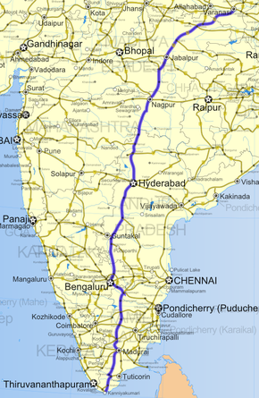
Road map of India with National Highway 7 highlighted in solid BLUE colorRoute information Length: 2,369 km (1,472 mi)
GQ: 94 km (58 mi) (Bengaluru - Krishnagiri)
NS: 1828 km (Lakhnadon - Kanyakumari)Major junctions North end: Varanasi, Uttar Pradesh List- NH 2 in Varanasi
- NH 29 in Varanasi
- NH 56 in Varanasi
- NH 27 in Mangawan
- NH 75 in Rewa
- NH 78 in Katni
- NH 12 in Jabalpur
- NH 26 in Lakhnadon
- NH 69 in Nagpur
- NH 6 in Nagpur
- NH 16 in Armoor
- NH 202 in Hyderabad
- NH 9 in Hyderabad
- NH 202 in Hyderabad
- NH 18 in Kurnool
- NH 63 in Gooty
- NH 206 in Anantpur
- NH 4 in Bangalore
- NH 209 in Bangalore
- NH 46 in Krishnagiri
- NH 66 in Krishnagiri
- NH 219 in Krishnagiri
- NH 68 in Salem
- NH 47 in Salem
- NH 67 in Karur
- NH 45 in Dindigul
- NH 209 in Dindigul
- NH 49 in Madurai
- NH 208 in Madurai
- NH 45B in Madurai
- NH 7A in Tirunelveli
- NH 47 in Kanyakumari
South end: Kanyakumari, Tamil Nadu Location States: Uttar Pradesh: 128 km (80 mi)
Madhya Pradesh: 504 km (313 mi)
Maharashtra: 232 km (144 mi)
Andhra Pradesh: 754 km (469 mi)
Karnataka: 125 km (78 mi)
Tamil Nadu: 627 km (390 mi)Primary
destinations:Varanasi - Rewa - Jabalpur - Nagpur - Hyderabad - Bangalore - Salem -Dindigul - Madurai - Virudhunagar - Tirunelveli - Kanyakumari Highway system Indian Road Network
National • Expressways • State
State Highways in ¬← NH 6 NH 7A → National Highway 7, commonly referred to as NH 7, is major North-South National Highway in India that runs through the states of Uttar Pradesh, Madhya Pradesh, Maharashtra, Andhra Pradesh, Karnataka, and Tamil Nadu. NH-7 was laid and is maintained by Central Public Works Department(CPWD).
The highway connects several important Indian cities such as Varanasi, Rewa, Jabalpur, Nagpur, Hyderabad, Bangalore, Salem, Virudhunagar, Tirunelveli, Dindigul, Madurai. A major part of NH 7 covers the North-South Corridor of NHDP and it is officially listed as running over 2,369 km (1,472 mi) from Varanasi to Kanyakumari. It is the longest national highway in India.
Contents
National Highway Development Project
-
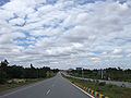
NH 7 in Karnataka, South Bound.
-
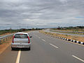
NH 7 at Nanguneri area in Tirunelveli district, Tamil Nadu
-

- A major stretch of NH 7 from Lakhnadon to Kanyakumari (1,828 km (1,136 mi)) has been selected as a part of the North-South Corridor by the National Highways Development Project.[1]
- Approximately 94 km (58 mi) stretch of NH 7 between Bengaluru and Krishnagiri has been selected as a part of the Golden Quadrilateral by the National Highways Development Project.[1]
References
- ^ a b "Highways Project". National Highways Authority of India. http://www.nhai.org/Doc/project-offer/Highways.pdf. Retrieved 2009-04-27.
External links
See also
- List of National Highways in India (by Highway Number)
- National Highways Development Project
- NH 7A
Indian Highways Network National Expressways NE 1 • NE 2


State Expressways Mumbai-Pune • Delhi-Gurgaon • DND Flyway • Bengaluru-Mysore • Chennai HSCTC • Hyderabad Elevated ExpresswaysNational Highways 1 • 1A • 1B • 1C • 1D • 2 • 2A • 3 • 4 • 4A • 4B • 5 • 5A • 6 • 7 • 7A • 8 • 8A • 8B • 8C • 8D • 8E • 9 • 10 • 11 • 11A • 11B • 12 • 12A • 13 • 14 • 15 • 16 • 17 • 17A • 17B • 18 • 19 • 20 • 21 • 21A • 22 • 23 • 24 • 24A • 24B • 25 • 25A • 26 • 26A • 27 • 28 • 28A • 28B • 28C • 29 • 30 • 30A • 31 • 31A • 31B • 31C • 31D • 32 • 33 • 34 • 35 • 36 • 37 • 37A • 38 • 39 • 40 • 41 • 42 • 43 • 44 • 44A • 45 • 45A • 45B • 45C • 46 • 47 • 47A • 47B • 47C • 48 • 49 • 50 • 51 • 52 • 52A • 52B • 53 • 54 • 54A • 55 • 56 • 57 • 57A • 58 • 59 • 59A • 60 • 60A • 61 • 62 • 63 • 64 • 65 • 66 • 67 • 68 • 69 • 70 • 71 • 71A • 71B • 72 • 72A • 73 • 73A • 74 • 75 • 76 • 77 • 78 • 79 • 79A • 80 • 81 • 82 • 83 • 84 • 85 • 86 • 86A • 87 • 88 • 89 • 90 • 91 • 91A • 92 • 93 • 94 • 95 • 96 • 97 • 98 • 99 • 100 • 101 • 102 • 103 • 104 • 105 • 106 • 107 • 108 • 109 • 110 • 111 • 112 • 113 • 114 • 116 • 117 • 119 • 121 • 123 • 125 • 126 • 127 • 128 • 129 • 150 • 151 • 152 • 153 • 154 • 155 • 200 • 201 • 202 • 203 • 203A • 204 • 205 • 206 • 207 • 208 • 209 • 210 • 211 • 212 • 213 • 214 • 214A • 215 • 216 • 217 • 218 • 219 • 220 • 221 • 222 • 223 • 224 • 226 • 227 • 228 • 229 • 234 • 235State Highways Andhra Pradesh • Arunachal Pradesh • Assam • Bihar • Chhattisgarh • Goa • Gujarat • Haryana • Himachal Pradesh • Jammu and Kashmir • Jharkhand • Karnataka • Kerala • Madhya Pradesh • Maharashtra • Manipur • Meghalaya • Mizoram • Nagaland • Orissa • Punjab • Rajasthan • Sikkim • Tamil Nadu • Tripura • Uttarakhand • Uttar Pradesh • West BengalNotable Categories:- National Highways in Uttar Pradesh
- National Highways in Madhya Pradesh
- National Highways in Maharashtra
- National Highways in Andhra Pradesh
- National Highways in Karnataka
- National Highways in Tamil Nadu
- Golden Quadrilateral
- Tirunelveli
- North–South and East–West Corridor
- Indian National Highways
- India road stubs


Wikimedia Foundation. 2010.