- National Highway 75 (India)
-
National Highway 75

75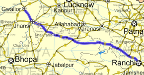
Road map of India with National Highway 75 highlighted in blueRoute information Length: 1,175 km (730 mi)
NS: 147 km (Gwalior - Jhansi)Major junctions From: Gwalior, Madhya Pradesh To: Parsora, Orissa Location States: Madhya Pradesh, Uttar Pradesh, Jharkhand, Orissa Primary
destinations:Jhansi - Rewa - Daltonganj - Ranchi Highway system Indian Road Network
National • Expressways • State
State Highways in ¬← NH 74 NH 76 →  NH75 India
National Highway 75 (NH 75 in short) is National Highway in India that links Gwalior in Madhya Pradesh to Parsora in Orissa. This 1,175 kilometres (730 mi) long highway passes through Datia, Jhansi, Chhatarpur, Panna, Satna, Rewa, Sidhi, Singrauli, Renukut, Garhwa, Daltonganj, Latehar, Chandwa, Ranchi, Khunti, Chakradharpur and Chaibasa[1] and is spread across Madhya Pradesh – 600 kilometres (370 mi), Uttar Pradesh – 110 kilometres (68 mi), Jharkhand – 447 kilometres (278 mi) and Orissa 18 kilometres (11 mi).
Contents
National Highway Development Project
- Approximately 147 km (91 mi) stretch of NH 75 between Gwalior and Jhansi has been selected as a part of the North-South Corridor by the National Highways Development Project.[2]
See also
- List of National Highways in India
- List of National Highways in India (by Highway Number)
- National Highways Development Project
References
- ^ "NH wise Details of NH in respect of Stretches entrusted to NHAI" (PDF). http://www.nhai.org/Doc/project-offer/Highways.pdf. Retrieved 2009-03-12.
- ^ [1] National Highways Authority of India (NHAI)
External links
- [2] NH 75 on MapsofIndia.com
Indian Highways Network National Expressways NE 1 • NE 2


State Expressways Mumbai-Pune • Delhi-Gurgaon • DND Flyway • Bengaluru-Mysore • Chennai HSCTC • Hyderabad Elevated ExpresswaysNational Highways 1 • 1A • 1B • 1C • 1D • 2 • 2A • 3 • 4 • 4A • 4B • 5 • 5A • 6 • 7 • 7A • 8 • 8A • 8B • 8C • 8D • 8E • 9 • 10 • 11 • 11A • 11B • 12 • 12A • 13 • 14 • 15 • 16 • 17 • 17A • 17B • 18 • 19 • 20 • 21 • 21A • 22 • 23 • 24 • 24A • 24B • 25 • 25A • 26 • 26A • 27 • 28 • 28A • 28B • 28C • 29 • 30 • 30A • 31 • 31A • 31B • 31C • 31D • 32 • 33 • 34 • 35 • 36 • 37 • 37A • 38 • 39 • 40 • 41 • 42 • 43 • 44 • 44A • 45 • 45A • 45B • 45C • 46 • 47 • 47A • 47B • 47C • 48 • 49 • 50 • 51 • 52 • 52A • 52B • 53 • 54 • 54A • 55 • 56 • 57 • 57A • 58 • 59 • 59A • 60 • 60A • 61 • 62 • 63 • 64 • 65 • 66 • 67 • 68 • 69 • 70 • 71 • 71A • 71B • 72 • 72A • 73 • 73A • 74 • 75 • 76 • 77 • 78 • 79 • 79A • 80 • 81 • 82 • 83 • 84 • 85 • 86 • 86A • 87 • 88 • 89 • 90 • 91 • 91A • 92 • 93 • 94 • 95 • 96 • 97 • 98 • 99 • 100 • 101 • 102 • 103 • 104 • 105 • 106 • 107 • 108 • 109 • 110 • 111 • 112 • 113 • 114 • 116 • 117 • 119 • 121 • 123 • 125 • 126 • 127 • 128 • 129 • 150 • 151 • 152 • 153 • 154 • 155 • 200 • 201 • 202 • 203 • 203A • 204 • 205 • 206 • 207 • 208 • 209 • 210 • 211 • 212 • 213 • 214 • 214A • 215 • 216 • 217 • 218 • 219 • 220 • 221 • 222 • 223 • 224 • 226 • 227 • 228 • 229 • 234 • 235State Highways Andhra Pradesh • Arunachal Pradesh • Assam • Bihar • Chhattisgarh • Goa • Gujarat • Haryana • Himachal Pradesh • Jammu and Kashmir • Jharkhand • Karnataka • Kerala • Madhya Pradesh • Maharashtra • Manipur • Meghalaya • Mizoram • Nagaland • Orissa • Punjab • Rajasthan • Sikkim • Tamil Nadu • Tripura • Uttarakhand • Uttar Pradesh • West BengalNotable Categories:- National Highways in Madhya Pradesh
- National Highways in Uttar Pradesh
- National Highways in Jharkhand
- National Highways in Orissa
- North–South and East–West Corridor
- Indian National Highways
- India road stubs


Wikimedia Foundation. 2010.