- Pamir Mountains
-
Coordinates: 39°N 72°E / 39°N 72°E
Pamir Mountains Range 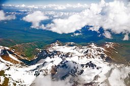 Pamir Mountains from an airplane, June 2008
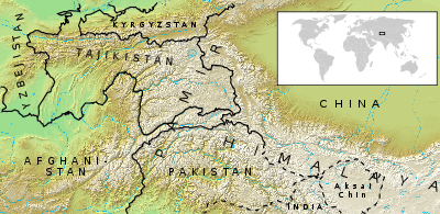
Countries Tajikistan, Kyrgyzstan, Afghanistan, Pakistan, China Regions Gorno-Badakhshan, Wakhan, North-West Frontier Province, Gilgit-Baltistan, Xinjiang of China Highest point Ismail Samani Peak - elevation 7,495 m (24,590 ft) - coordinates 38°55′N 72°01′E / 38.917°N 72.017°E  The Pamirs are situated in Afghanistan, China, Kyrgyzstan, Pakistan, Gilgit-Baltistan, and Tajikistan
Pamir Mountains Chinese name Simplified Chinese 帕米尔高原 Traditional Chinese 帕米爾高原 Transcriptions Mandarin - Hanyu Pinyin Pàmǐ'ěr Gāoyuán - Wade–Giles P'a4-mi3-erh3 Kao1-yüan2 Alternative Chinese name Simplified Chinese 葱嶺 Traditional Chinese 蔥嶺 Literal meaning Onion range[1][2] Transcriptions Mandarin - Hanyu Pinyin Cōnglǐng - Wade–Giles Ts'ung1-ling3 Hindi name Hindi पामीर पर्वतमाला Uyghur name Uyghur پامىر ئېگىزلىكىKyrgyz name Kyrgyz Памир тоолору Persian name Persian رشته کوه های پامیر
Reshte Kūh-hāye PāmīrTajik name Tajik Кӯҳҳои Помир Urdu name Urdu پامیر کوهستان The Pamir Mountains are a mountain range in Central Asia formed by the junction or knot of the Himalayas, Tian Shan, Karakoram, Kunlun, and Hindu Kush ranges. They are among the world’s highest mountains and since Victorian times they have been known as the "Roof of the World" a probable translation from the Persian.[3][4]
The precise extent of the Pamir Mountains is debatable.[5] They lie mostly in Gorno-Badakhshan province, Tajikistan and Badakshan Province, Afghanistan. To the north they join the Tian Shan mountains along the Alay Valley of Kyrgyzstan. To the south they join the Hindu Kush mountains along the Wakhan Corridor in Afghanistan/Pakistan, and also Gilgit-Baltistan in Pakistan. To the east they may end on the Chinese border or extend to the range that includes Kongur Tagh which is sometimes included in the Kunlun Mountains.
The Pamir Mountains were prominently featured in the 1985 film, Spies Like Us starring Chevy Chase and Dan Aykroyd. They were even described by Austin Milbarge (Aykroyd) as being "the roof of the world" and having "sub-Arctic temperatures".
Contents
Geography
Its three highest mountains are Ismoil Somoni Peak (known from 1932–1962 as Stalin Peak, and from 1962–1998 as Communism Peak), 7,495 m (24,590 ft); Ibn Sina Peak (still unofficially known as Lenin Peak), 7,134 m (23,406 ft); and Peak Korzhenevskaya (Russian: Пик Корженевской, Pik Korzhenevskoi), 7,105 m (23,310 ft).[6]
There are many glaciers in the Pamir Mountains, including the 77 km (48 mi) long Fedchenko Glacier, the longest in the former USSR and the longest glacier outside the Polar region.[7]
Climate
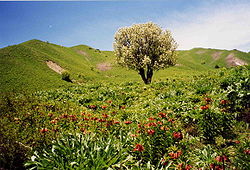 Part of the Pamir Mountain range in springtime.
Covered in snow throughout the year, the Pamirs have long and bitterly cold winters, and short, cool summers. Annual precipitation is about 130 mm (5 in), which supports grasslands but few trees.
Economy
Coal is mined in the west, though sheep herding in upper meadowlands are the primary source of income for the region.
Exploration
- This section is based on the book by R. Middleton and H. Thomas[8]
The lapis lazuli found in Egyptian tombs is thought to come from the Pamir area in Badakhshan province of Afghanistan. About 138 BC Zhang Qian reached the Fergana Valley northwest of the Pamirs. Ptolemy vaguely describes a trade route though the area. From about 600 AD, Buddhist pilgrims travelled on both sides of the Pamirs to reach India from China. In 747 a Tang army was on the Wakhan River. There are various Arab and Chinese reports. Marco Polo may have travelled along the Panj River. In 1602 Bento de Goes travelled from Kabul to Yarkand and left a meager report on the Pamirs. In 1838 Lieutenant John Wood reached the headwaters of the Pamir River. From about 1868 to 1880, a number of Indians in the British service secretly explored the Panj area. In 1873 the British and Russians agreed to an Afghan frontier along the Panj River. From 1871 to around 1893 several Russian military-scientific expeditions mapped out most of the Pamirs (Alexei Pavlovich Fedchenko, Nikolai Severtzov, Captain Putyata and others. Later came Nikolai Korzhenevskiy). Several local groups asked for Russian protection from Afghan raiders. The Russians were followed by a number of non-Russians including Ney Elias, George Littledale, the Earl of Dunmore, Wilhelm Filchner and Lord Curzon who was probably the first to reach the Wakhan source of the Oxus River. In 1891 the Russians informed Francis Younghusband that he was on their territory and later escorted a Lieutenant Davidson out of the area ('Pamir Incident'). In 1892 a battalion of Russians under Mikhail Ionov entered the area and camped near the present Murghab. In 1893 they built a proper fort there (Pamirskiy Post). In 1895 their base was moved to Khorog facing the Afghans.
In 1928 the last blank areas around the Fedchenko Glacier were mapped out by a German-Soviet expedition under Willi Rickmer Rickmers.
'A pamir'
According to Middleton and Thomas, 'pamir' is also a geological term.[8] A pamir is a flat plateau or U-shaped valley surrounded by mountains. It forms when a glacier or ice field melts leaving a rocky plain. A pamir lasts until erosion forms soil and cuts down normal valleys. This type of terrain is found in the east and north of the Wakhan,[9] and the east and south of Gorno-Badakhshan, as opposed to the valleys and gorges of the west. Pamirs are used for summer pasture.[8][9]
The Great Pamir is around Lake Zorkul. The Little Pamir is east of this in the far east of Wakhan.[9] The Taghdumbash Pamir is between Tashkurgan and the Wakhan west of the Karakoram Highway. The Alichur Pamir is around Yashil Kul on the Gunt River. The Sarez Pamir is around the town of Murghab. The Khargush Pamir is south of Lake Karakul. There are several others.
The Pamir River is in the south-west of the Pamirs.
Discoveries
In the early 1980s, a deposit of gemstone-quality clinohumite was discovered in the Pamir Mountains. It was the only such deposit known until the discovery of gem-quality material in the Taymyr region of Siberia, in 2000.[citation needed]
Transportation
The Pamir Highway, the world's second highest international road, runs from Dushanbe in Tajikistan to Osh in Kyrgyzstan through the Gorno-Badakhshan Autonomous Province, and is the isolated region's main supply route. The Great Silk Road crossed a number of Pamir Mountain ranges.[10]
Tourism
In December 2009, the New York Times featured articles on the possibilities for tourism in the Pamir area of Tajikistan.[11][12]
Strategic position
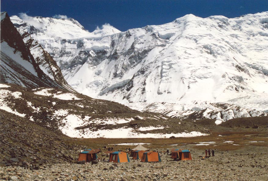
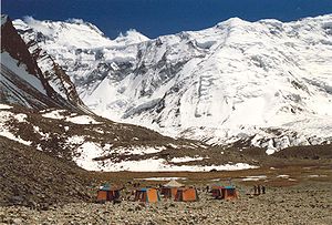 Ismoil Somoni Peak (then known as Peak Communism) taken in 1989
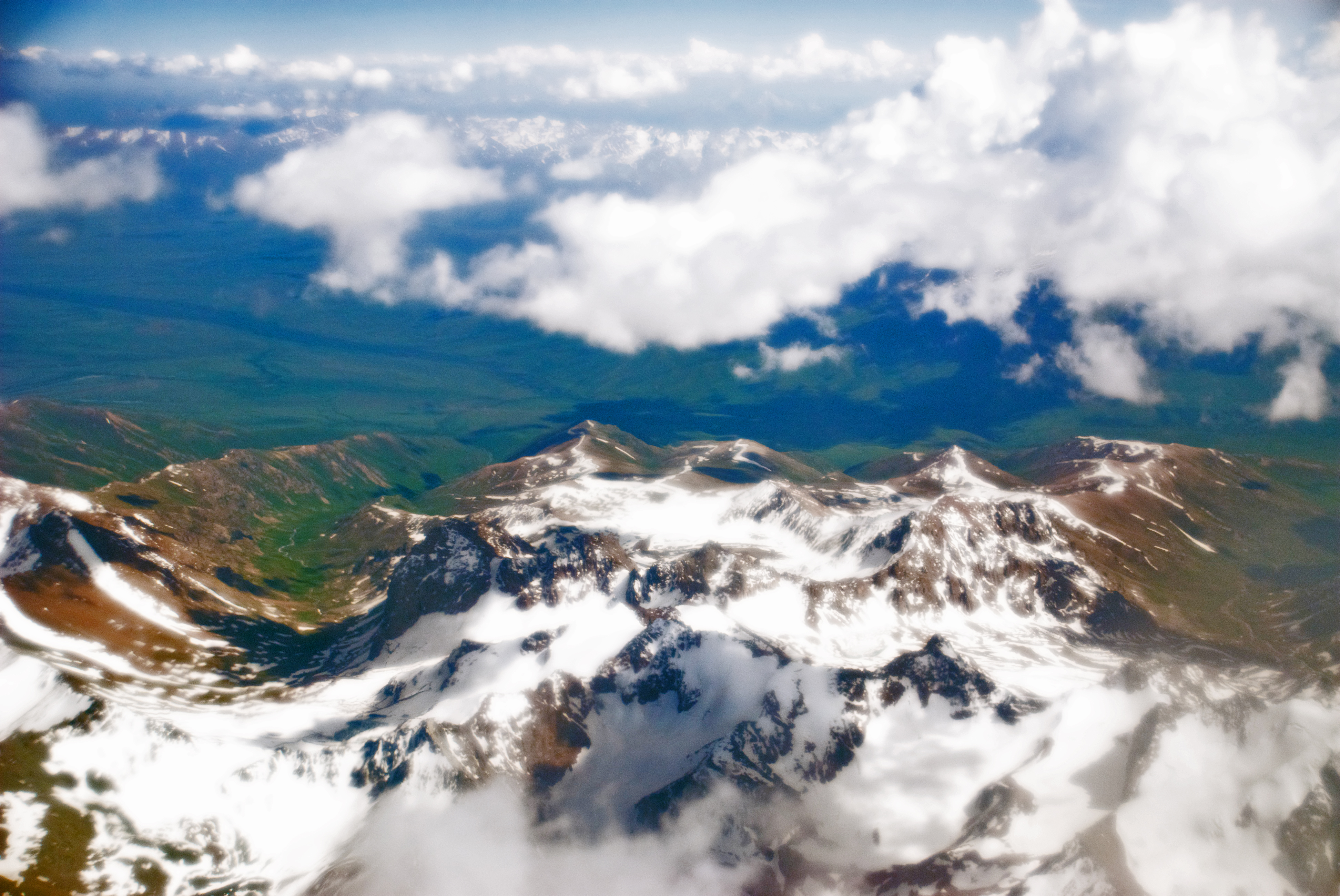
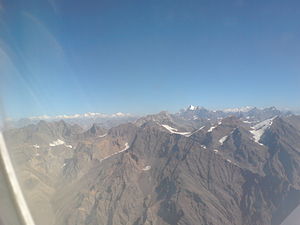 Flying over Pamir
 Climbers near "Peak Communism" in 1978
Historically, the Pamir Mountains were considered a strategic trade route between Kashgar and Kokand on the Northern Silk Road and have been subject to numerous territorial conquests. The Northern Silk Road (about 2,600 km (1,616 mi) in length) connected the ancient Chinese capital of Xian to the west over the Pamir Mountains to emerge in Kashgar before linking to ancient Parthia.[13] In the 20th century, they have been the setting for Tajikistan Civil War, border disputes between China and Soviet Union, establishment of US, Russian, and Indian military bases,[14] and renewed interest in trade development and resource exploration.[15][16]
See also
- Pamir National Park
- Pamir languages
- List of mountain ranges
- List of highest mountains
- Soviet Central Asia
- Central Asia
- Mount Imeon
References
- ^ 水經注 (quoting from the 西河舊事): ”蔥嶺在敦煌西八千里,其山高大,上生蔥,故曰蔥嶺也。“, in English: "The Onion Range is 8,000 Li west of Dunhuang. Its mountains are high and onions grow on them, therefore it is called Onion Range."
- ^ "The origin of the Chinese name "Onion Range" for Pamir". Depts.washington.edu. 2002-04-14. http://depts.washington.edu/silkroad/texts/weilue/notes1_3.html. Retrieved 2009-08-10.
- ^ Encyclopedia Britannica 11th ed. 1911: PAMIRS, a mountainous region of central Asia...the Bam-i-dunya ("The Roof of the World"); The Columbia Encyclopedia, 1942 ed., p.1335: "Pamir (Persian = roof of the world)";The Pamirs, a region known to the locals as Pomir – “the roof of the world".
- ^ Social and Economic Change in the Pamirs, pp. 13-14, by Frank Bliss, Routledge, 2005, ISBN 0415308062, ISBN 9780415308069: Pamir = a Persian compilation of pay-I-mehr, the "roof of the world".
- ^ According to the Big Soviet Encyclopedia "The question of the natural boundaries of Pamir is debatable. Normally Pamir is regarded as covering the territory from Trans-Alay Range to the North, Sarykol Range to the East, Lake Zorkul, Pamir River, and the upper reaches of Panj River to the South, and the meridional section of the Panj valley to the West; to the north-west Pamir includes the eastern parts of Peter the Great and Darvaz ranges."
- ^ Tajikistan: 15 Years of Independence, statistical yearbook, Dushanbe, 2006, p. 8, in Russian.
- ^ In the Karakoram Mountains, Siachen Glacier is 70 km long, Biafo Glacier is 63 km long, and Baltura and Baltoro are 57 km long. The Bruggen or Pio XI Glacier in southern Chile is 64 km long. Kyrgyzstan's South Inylchek (Enylchek) Glacier is 62 km in length. Measurements are from recent imagery, generally with Russian 1:200,000 scale topographic mapping for reference as well as the 1990 Orographic Sketch Map: Karakoram: Sheets 1 and 2, Swiss Foundation for Alpine Research, Zurich.
- ^ a b c Robert Middleton and Huw Thomas, 'Tajikistan and the High Pamirs',Odyssey Books, 2008
- ^ a b c Aga Khan Development Network (2010): Wakhan and the Afghan Pamir p.3
- ^ "Official Website of Pamir Travel". Pamir Travel. http://www.travel-pamir.com/gp3.html. Retrieved 2007-08-03.
- ^ "The Pamir Mountains of Tajikistan"
- ^ "Pamir Mountains, the Crossroads of History"
- ^ "''Silk Road, North China'', C.Michael Hogan, the Megalithic Portal, ed. A. Burnham". Megalithic.co.uk. http://www.megalithic.co.uk/article.php?sid=18006. Retrieved 2009-08-10.
- ^ "India's `Pamir Knot'". The Hindu. http://www.hinduonnet.com/thehindu/2003/11/11/stories/2003111101861200.htm. Retrieved 2007-08-03.
- ^ "The West Is Red". Time. http://www.time.com/time/magazine/article/0,9171,1218611-1,00.html. Retrieved 2007-08-26.
- ^ "Huge Market Potential at China-Pakistan Border". China Daily. http://www.china.org.cn/english/2005/Jun/132201.h. Retrieved 2007-08-26.[dead link]
Further reading
- Curzon, George Nathaniel. 1896. The Pamirs and the Source of the Oxus. Royal Geographical Society, London. Reprint: Elibron Classics Series, Adamant Media Corporation. 2005. ISBN 1-4021-5983-8 (pbk; ISBN 1-4021-3090-2 (hbk).
- Gordon, T. E. 1876. The Roof of the World: Being the Narrative of a Journey over the high plateau of Tibet to the Russian Frontier and the Oxus sources on Pamir. Edinburgh. Edmonston and Douglas. Reprint by Ch’eng Wen Publishing Company. Taipei. 1971.
- Toynbee, Arnold J. 1961. Between Oxus and Jumna. London. Oxford University Press.
- Wood, John, 1872. A Journey to the Source of the River Oxus. With an essay on the Geography of the Valley of the Oxus by Colonel Henry Yule. London: John Murray.
- Horsman, S. 2002. Peaks, Politics and Purges: the First Ascent of Pik Stalin in Douglas, E. (ed.) Alpine Journal 2002 (Volume 107), The Alpine Club & Ernest Press, London, pp 199–206.
- Leitner, G. W. 1890. Dardistan in 1866, 1886 and 1893: Being an Account of the History, Religions, Customs, Legends, Fables and Songs of Gilgit, Chilas, Kandia (Gabrial) Yasin, Chitral, Hunza, Nagyr and other parts of the Hindukush. With a supplement to the second edition of The Hunza and Nagyr Handbook. And an Epitome of Part III of the author’s “The Languages and Races of Dardistan”. First Reprint 1978. Manjusri Publishing House, New Delhi.
- Strong, Anna Louise. 1930. The Road to the Grey Pamir. Robert M. McBride & Co., New York.
- Slesser, Malcolm "Red Peak: A Personal Account of the British-Soviet Expedition" Coward McCann 1964
- Tilman, H. W. "Two Mountains and a River" part of "The Severn Mountain Travel Books". Diadem, London. 1983
- Waugh, Daniel C. 1999. "The ‘Mysterious and Terrible Karatash Gorges’: Notes and Documents on the Explorations by Stein and Skrine." The Geographical Journal, Vol. 165, No. 3. (Nov., 1999), pp. 306-320.
External links
- Photos of the Tajik Pamirs, with emphasis on Wakhan area
- Information and photos
- The Pamirs. 1:500.000 - A tourist map of Gorno-Badkshan-Tajikistan and background information on the region. Verlag „Gecko-Maps“, Switzerland 2004 (ISBN 3-906593-35-5)
- Tourist office in Khorog (Tajikistan) Pamirs Tourism Association
- Photos of the life of ethnic Kyrgyz in Afghan's Little Pamir
- Photos and Online Guide to Trekking in the Wakhan and Afghan Pamir Juldu.com
Mountain ranges of China Ailao Mountains · Altai Mountains · Argu Tagh · Changbai Mountains · Daba Mountains · Dabie Mountains · Dalou Mountains · Daxue Mountains · Dzungarian Alatau · Greater Khingan · Helan Mountains · Hengduan Mountains · Himalayas · Jiuling Mountains · Jiuyi Mountains · Karakoram · Kunlun Mountains · Lesser Khingan · Luoxiao Mountains · Lüliang Mountains · Huangshan · Jingshan Mountains · Mount Lang · Min Mountains · Mufu Mountains · Nanling Mountains · Pamir Mountains · Qian Mountains · Qin Mountains · Qionglai Mountains · Taihang Mountains · Tarbagatai Mountains · Tian Shan · Tanggula Mountains · Wanda Mountains · Wudang Mountains · Wuling Mountains · Wuyi Mountains · Xuefeng Mountains · Yengisogat · Yin Mountains · Yunling Mountains · Zhongtiao Mountains Landforms of China
Xinjiang topics General Geography Cities • Tian Shan • Dzungarian Basin • Tarim Basin • Gurbantünggüt Desert • Kumtag Desert • Taklimakan Desert • Turpan Depression • Karakoram Mountains • Altai Mountains • Tian Shan • Kunlun Shan • Pamir Mountains • Torugart Pass • Karakoram PassEducation Culture Cuisine Dapanji • Sangza • Samsa • Youtazi • Pamirdin • Xurpa • Tohax • Tunurkawab • Chinese Islamic cuisineVisitor attractions Apak Khoja and Xiang Fei Tomb • Flaming Mountains • Jiaohe Ruins • Gaochang • Grand Bazaar, Ürümqi • Id Kah Mosque • Karakul Lake • Kizil Caves • Ruins of NiyaCategories:- Geography of Central Asia
- Mountains of Asia
- Mountain ranges of Asia
- Mountain ranges of China
- Mountain ranges of Afghanistan
- Mountain ranges of Tajikistan
- Mountains of Afghanistan
- Mountain ranges of Kyrgyzstan
- Physiographic provinces


Wikimedia Foundation. 2010.