- Mount Imeon
-
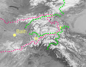 Mount Imeon area with the ancient Bulgar lands according to Acad. Suren T. Eremian’s reconstruction of the original ‘Ashharatsuyts’ map of Central Asia.
Mount Imeon is an ancient name for the Central Asian complex of mountain ranges comprising the present Hindu Kush, Pamir and Tian Shan, extending from the Zagros Mountains in the southwest to the Altay Mountains in the northeast, and linked to the Kunlun, Karakoram and Himalayas to the southeast. See also Roof of the World.
Contents
Geography
A detailed description of the mountainous territory and its people was given in the Armenian geography index Ashharatsuyts written by Anania Shirakatsi in the 7th century AD[1][2] (or possibly by Moses of Chorene in the 5th century.[3]) According to the original Ashharatsuyts mapping reconstructed by Acad. Suren T. Eremian, the mountain system was divided into four branches (green dots in the map) corresponding respectively to four present ranges:
- Southern Imeon (‘Emavon’ in Armenian): Hindu Kush;
- Southeastern Imeon: Badakhshan and Pamir;
- Northern Imeon: Alay Mountains and the Tian Shan ranges situated north of Fergana Valley;
- Northeastern Imeon: central and eastern part of Tian Shan
The mountains bordered the lands of China in the east, India in the south, Aria in the west (the region around modern Herat, marked as ‘Arya’ on Eremian's map[1]), and Khwarezm in the northwest.
The mountain system was crossed by a segment of the Silk Road leading westwards from Yarkand to the Stone Tower in eastern Pamir (mentioned by Ptolemy, and shown on the Ashharatsuyts map too), then through the Wakhan Corridor and Badakhshan to reach the ancient major city of Balh (Balkh). An alternative Northern Silk Road[4] went from Kashgar to upper Alay Valley, then crossed the Alay Mountains to enter Fergana Valley.
Mount Imeon was famous for its lapis lazuli deposits in western Badakhshan, indicated on Shirakatsi’s map. The mines at Sar-e-Sang have been producing lapis lazuli for one millennia now, supplying the ancient civilizations of Egypt, Mesopotamia, India, and Rome, and still yielding the world’s finest lapis. The Venetian adventurer Marco Polo visited the mines in 1271 during his famous journey to China, following the Silk Road to cross the mountains by way of Wakhan.[5]
Population
According to Ashharatsuyts[1][2] the Central Asian territory west of Imeon was inhabited in Antiquity by fifteen old artisan and trading nations: Massagetae, Bulgars (Bulhi in Armenian; Shirakatsi uses the same name for the Bulgars who inhabited the valleys of Northern Caucasus at his time, and according to Moses of Chorene had settled also the Bulgarian - Armenian principality of Vanand before that[6]), Khwarezmians (‘Horozmiki’) etc., and by forty-three nomadic tribes including the Hephthalites and Alchons.Apart from Anania Shirakatsi, other historiographers in late Antiquity and the Early Middle Ages such as Agathias of Myrina, Theophylact Simocatta, and Michael the Syrian also identify Mount Imeon as an early homeland of the ancient Bulgars - where the ancient Kingdom of Balhara was located[7][8][9]
Honour (Bulgarian)
Imeon Range on Smith Island in the South Shetland Islands, Antarctica is named after Mount Imeon - Bulgarian honour (from the links of the kingdom of Balhara to the Bulgars).
Notes
- ^ a b c Eremian, Suren. Reconstructed map of Central Asia from ‘Ashharatsuyts’.
- ^ a b Shirakatsi, Anania, The Geography of Ananias of Sirak (Asxarhacoyc): The Long and the Short Recensions. Introduction, Translation and Commentary by Robert H. Hewsen. Wiesbaden: Reichert Verlag, 1992. 467 pp. ISBN 9783882264852
- ^ Haroutunian, Babken. [http://www.matenadaran.org/en/articles/61/ Historical Geograpvan: Matenadaran, 2007.
- ^ Hogan, C. Michael. Silk Road, North China. The Megalithic Portal, edited by A. Burnham. 2007.
- ^ Polo, Marco and Rustichello of Pisa. The Travels of Marco Polo, Vol. 1. Ed. Henry Yule (1903), and Henry Cordier (1920). Gutenberg Project, 2004.
- ^ Khorenatsi, Moses. History of the Armenians. Translation and Commentary of the Literary Sources by Robert W. Thomson. Cambridge, Massachusetts: Harvard University Press, 1978. 400 pp. ISBN 9780674395718
- ^ http://www.state.gov/r/pa/ei/bgn/3236.htm
- ^ http://sitemaker.umich.edu/mladjov/files/bulgarian_rulers.pdf
- ^ http://en.academic.ru/dic.nsf/enwiki/8511032
References
- Bakalov, Georgi. Little known facts of the history of ancient Bulgarians. Science Magazine. Union of Scientists in Bulgaria. Vol. 15 (2005) Issue 1. (in Bulgarian)
- Dimitrov, Bozhidar. Bulgarians and Alexander of Macedon. Sofia: Tangra Publishers, 2001. 138 pp. (in Bulgarian) ISBN 9549942295
- Dobrev, Petar. Unknown Ancient Bulgaria. Sofia: Ivan Vazov Publishers, 2001. 158 pp. (in Bulgarian) ISBN 9546041211
- Shirakatsi, Anania. Geography Guide (VII Century AD). Russian version: Армянская География VII века по Р.Х. (Приписывавшаяся Моисею Хоренскому). Tекст и перевод с присовокуплением карт и объяснительных примечаний издал К.П. Патканов. Санктпетербург: Типография Императорской Академии Наук, 1877. (An early modern publication, less detailed than later ones.)
- US Department of State. Background Note: Bulgaria. Historical Highlights.
Categories:- Former place names
- Bulgars
- Geography of Central Asia
- History of Central Asia
- Mountain ranges of Asia

Wikimedia Foundation. 2010.