- Min Mountains
-
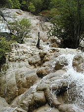 A waterfall at the Huanglong site
Min Mountains or Minshan (Chinese: 岷山; pinyin: Min Shan) are a mountain range in central China. It runs in the general north-south direction through northern Sichuan (the eastern part of the Ngawa Tibetan and Qiang Autonomous Prefecture and adjacent areas of Mianyang Prefecture-level city) and southernmost borderlands of Gansu. The highest elevation is Mt Xuebaoding ("Snow Treasure Peak"), 5588 m.
The Min mountain range separates the basins of two major rivers of Sichuan: the Min River (to the west) and the Jialing River (to the east). Both rivers flow in the general southern direction, and are tributaries of the Yangtze.
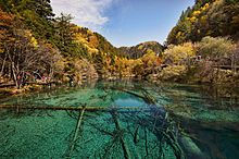 In the Jiuzhaigou Valley
The characteristic ecosystem of the Min Mountains and the Qionglai Mountains (which are located further west, separated from the Min Mountains by the Min River valley) has been described by the World Wildlife Fund as the Qionglai-Minshan conifer forests.[1]
Important tourism and nature conservation objects in the Min Mountains include the Jiuzhaigou Valley Nature Reserve (in Jiuzhaigou County) and the Huanglong Scenice and Historic Interest Area (in Songpan County); both are listed on the UNESCO World Heritage Sites list.
The Lazikou Pass, a site of strategical importance during the Long March, passes through the Min Mountains and connects northewestern Sichuan with southern Gansu.
References
Mountain ranges of China Geography of China Ailao Mountains · Altai Mountains · Argu Tagh · Changbai Mountains · Daba Mountains · Dabie Mountains · Dalou Mountains · Daxue Mountains · Dzungarian Alatau · Greater Khingan · Helan Mountains · Hengduan Mountains · Himalayas · Jiuling Mountains · Jiuyi Mountains · Karakoram · Kunlun Mountains · Lesser Khingan · Luoxiao Mountains · Lüliang Mountains · Huangshan · Jingshan Mountains · Mount Lang · Min Mountains · Mufu Mountains · Nanling Mountains · Pamir Mountains · Qian Mountains · Qin Mountains · Qionglai Mountains · Taihang Mountains · Tarbagatai Mountains · Tian Shan · Tanggula Mountains · Wanda Mountains · Wudang Mountains · Wuling Mountains · Wuyi Mountains · Xuefeng Mountains · Yengisogat · Yin Mountains · Yunling Mountains · Zhongtiao Mountains Landforms of ChinaCategories:
- Geography of Sichuan
- Geography of Gansu
- Mountain ranges of China
- Sichuan geography stubs


Wikimedia Foundation. 2010.