- Mianyang
-
Mianyang
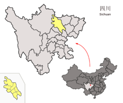
绵阳— Prefecture-level city — 绵阳市 Location of Mianyang City jurisdiction (yellow) within Sichuan Location in Sichuan Coordinates: 31°28′N 104°41′E / 31.467°N 104.683°ECoordinates: 31°28′N 104°41′E / 31.467°N 104.683°E Country People's Republic of China Province Sichuan City seat Fucheng (涪城区) Area – Prefecture-level city 20,281 km2 (7,830.5 sq mi) – Urban 1,570 km2 (606.2 sq mi) – Metro 1,570 km2 (606.2 sq mi) Elevation 473 m (1,552 ft) Highest elevation 5,588 m (18,333 ft) Lowest elevation 307 m (1,007 ft) Population (2010 census) – Prefecture-level city 4,613,862 – Density 227.5/km2 (589.2/sq mi) – Urban 985,586 – Urban density 627.8/km2 (1,625.9/sq mi) – Metro 985,586 – Metro density 627.8/km2 (1,625.9/sq mi) Time zone China Standard (UTC+8) Postal code 621000 Area code(s) 0816 Website http://www.mianyang.gov.cn/ Mianyang (simplified Chinese: 绵阳; traditional Chinese: 綿陽; pinyin: Miányáng) is the second largest prefecture-level city of Sichuan province in Southwest China. Its administrative area includes the city proper of Mianyang, with 985,586 inhabitants in the built up area (2 urban counties), the county-level city of Jiangyou, and six counties, covering an area of over {{convert/{{{2}}}|20281km²|0|||||||r=re|d=LoffAoffDbSoff|s=}} and a population of 4,613,862 at the 2010 census.
Contents
History
Mianyang, called Fujun in ancient times, had advanced in agriculture during the Qin (221–206 BCE) and Han (206 BCE–220 CE) dynasties. It has a history of over 2,200 years since the Emperor Gaozu of Han established the first county in this area in 201 BCE. Due to its advantageous geographic location, it had always been a town of great military importance and formed a natural defence for Chengdu. [1] Mianyang is home to the CAEP and Science City, an immense Military Research Complex which was the site of the development of China first nuclear bomb.
The city proper itself was only lightly damaged by the earthquake of 12 May 2008. However, Beichuan County, which is in the prefecture is among the most severely hit of all disaster regions following the earthquake, including the Beichuan High School campus, where more than 1,000 students lost their lives after two main buildings collapsed.[2] Around 80% of the county's buildings are said to have collapsed, including its main government building.[3] The casualty toll for the quake in Mianyang Prefecture as of 7 June 2008 was 21,963 people killed, 167,742 injured, and 8,744 people missing.[4][5]
Geography and climate
Mianyang is located at the northwestern end of the Sichuan Basin, on the upper to middle reaches of the Fu River. Its administrative area ranges in latitude from 30° 42' to 33° 03' N and in longitude from 103° 45' to 105° 43' E. Bordering prefectures are Guangyuan to the northeast, Nanchong to the east, Suining to the south, Deyang to the southwest, Ngawa Tibetan Autonomous Prefecture to the west. It also borders Gansu province for a small section in the north.
Mianyang has a monsoon-influenced humid subtropical climate (Köppen Cwa) and is largely mild and humid, with four distinct seasons. Winter is short, mild, and foggy, though actual precipitation is low. January averages 5.3 °C (41.5 °F), and while frost may occur, snow is rare. Summers are long, hot and humid, with highs often exceeding 30 °C (86 °F). The daily average in July, the warmest month, is 25.7 °C (78.3 °F). Rainfall is light in winter and can be heavy in summer, and more than 70% of the annual total occurs from May to September. The annual frost-free period across most of the prefecture lasts from 252 to 300 days, and there are only 1,100 hours of sunshine annually, which is not even 30% of the possible total.
Climate data for Mianyang (1971−2000) Month Jan Feb Mar Apr May Jun Jul Aug Sep Oct Nov Dec Year Average high °C (°F) 9.6
(49.3)11.6
(52.9)16.1
(61.0)22.3
(72.1)26.7
(80.1)28.7
(83.7)30.1
(86.2)30.5
(86.9)25.5
(77.9)21.0
(69.8)16.0
(60.8)10.9
(51.6)20.8 Average low °C (°F) 2.0
(35.6)4.1
(39.4)7.7
(45.9)12.5
(54.5)17.4
(63.3)20.9
(69.6)22.4
(72.3)21.9
(71.4)18.7
(65.7)14.3
(57.7)8.8
(47.8)3.6
(38.5)12.9 Precipitation mm (inches) 8.5
(0.335)11.7
(0.461)20.2
(0.795)46.7
(1.839)71.4
(2.811)107.0
(4.213)218.7
(8.61)192.2
(7.567)131.4
(5.173)38.7
(1.524)14.5
(0.571)4.5
(0.177)865.5
(34.075)Avg. precipitation days (≥ 0.1 mm) 5.6 7.0 9.5 11.2 13.4 14.3 15.4 13.1 14.9 12.7 6.6 4.0 127.7 Source: Weather China Transport
The city has both highway and railway connections to several major cities, and is situated on the road from Xi'an to the provincial capital of Chengdu as well as the Baocheng Railway running from Baoji in Shaanxi province to Chengdu.
Mianyang Airport has direct flights to Beijing, Shanghai, Guangzhou, Shenzhen, Kunming, and Hangzhou.
Economy
Mianyang is one of China's major centres for the electronics industry. It has many well-known research institutions, such as the China Academy of Engineering Physics and China Aerodynamics Research and Development Center. Many large-scale enterprises, such as Changhong Electronics Group Corporation, Sichuan DND Pharmaceutical Co.,Ltd., Jiuzhou Electronics Group, Shuangma Cement Group, and Changcheng Special Steel Company also have their home in Mianyang.
Mianyang is an important national defence, scientific research and production base, consisting of 18 institutes including the China Academy of Engineering Physics and the China Aerodynamics Research Institute. Moreover, it houses 50 large and medium size enterprises, and six science colleges.
The provincial government will hand over greater administrative powers of economic management at the provincial-level authority to propel the development of Mianyang. The new economy management authority will pay close attention to the construction of the scientific city. The provincial committee party and government are presently drafting the "Opinions on Propelling China Scientific City Construction" report which is expected to come out soon.
Development Zone
- Mianyang Hi-Tech Industrial Development Zone
Mianyang Hi-Tech Industrial Development Zone was established in 1992, with a planned area of 43 square kilometers. The zone is situated 96 kilometers away from Chengdu, and is 8 km away from Mianyang Airport. Since its establishment, the zone accumulated 177.4 billion yuan of industrial output, 46.2 billion yuan of gross domestic product, fiscal revenue 6.768 billion yuan. There are more than 136 high-tech enterprises in the zone and they accounted for more than 90% of the total industrial output. Zone is a leader in electronic information industry, biological medicine, new materials and production of motor vehicles and parts.[6]
Education
There are 6 universities and colleges in the city, and it is well known as a science and technology centre.
The most famous one is Southwest University of Science and Technology. SWUST is located in Mianyang City ---- the science and technology city of China, about 100 km away from Chengdu, the capital city of Sichuan Province, P. R. China. SWUST has a large, beautiful campus. The campus covers an area of 4000 mu (about 260 hectares). It is not only beautiful with green hills, clean rivers and luxuriant vegetation and but also equipped with advanced teaching facilitates. There is a wide-band multi-media campus network, which connected with Internet. The student dorm has an access of telephone, Internet and TV. There are over 900,000 copies of books and over 10,000 electronic books in the library. The studying and living facilities are all ready on the campus.
People
It is the hometown of the famous poet Li Bai, and boasts many historical relics of the Three Kingdoms period.
Several minorities live in Mianyang, such as the Tibetan and Qiang people.
Subdivisions
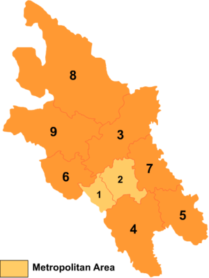
Map 
# Name Hanzi Hanyu Pinyin Population
(2004 est.)Area (km²) Density
(/km²)1 Fucheng District 涪城区 Fúchéng Qū 620,000 597 1,039 2 Youxian District 游仙区 Yóuxiān Qū 510,000 973 524 3 Jiangyou City 江油市 Jiāngyóu Shì 870,000 2,720 320 4 Santai County 三台县 Sāntái Xiàn 1,460,000 2,661 549 5 Yanting County 盐亭县 Yántíng Xiàn 590,000 1,645 359 6 An County 安县 Ān Xiàn 510,000 1,404 363 7 Zitong County 梓潼县 Zǐtóng Xiàn 380,000 1,438 264 8 Pingwu County 平武县 Píngwǔ Xiàn 190,000 5,974 32 9 Beichuan Qiang Autonomous County 北川羌族
自治县Běichuān Qiāngzú
Zìzhìxiàn160,000 2,869 56 References
- ^ "Mianyang Travel Guide". http://www.travelchinaguide.com/cityguides/sichuan/mianyang/.
- ^ "Eye witnesses of the earthquake disaster in Beichuan Middle School, Sichuan (Chinese: 四川北川中学震灾纪实)" (in Chinese). bczx.changhong.com. http://bczx.changhong.com/. Retrieved 2008-10-01.
- ^ Death toll in China earthquake rises to 7,600
- ^ "Casualties in Wenchuan Earthquake" (in Chinese). Sina.com. 2008-05-28. http://news.sina.com.cn/pc/2008-05-13/326/651.html. Retrieved 2008-05-28.
- ^ 21,963 deaths in Mianyang as of June 7, 18:00 CST,"Earthquake Information of Mianyang as of June 7" (in Chinese). Official website of Mianyang Government. 2008-06-08. http://www.mianyang.gov.cn/MYGOV/147211412819673088/20080608/301258.html. Retrieved 2008-06-08.
- ^ RightSite.asia | Mianyang Hi-Tech Industrial Development Zone
External links
Sichuan topics General History NationsBa & Shu · Chengjia · Shu Han · Cheng Han · Western Shu · Former Shu · Later Shu · Great Shu · Great Xia · Great XiEventsSichuan-Mongol War · Huguang Filling Sichuan · Railway Protection Movement · Home Front PeriodGeography Cities • Sichuan Basin • Chengdu Plain • Regions (West • East • North • South) • Rivers (Sichuan • Min • Jialing • Tuo • Yalong) • Mountain ranges (Daba • Longmen • Qionglai • Hengduan )Culture People Languages Visitor attractions see also: Greater Sichuan & ChongqingSichuan Province county-level divisions Chengdu: Qingyang District · Jinjiang District · Jinniu District · Wuhou District · Chenghua District · Longquanyi District · Qingbaijiang District · Xindu District · Wenjiang District · Dujiangyan City · Pengzhou City · Qionglai City · Chongzhou City · Jintang County · Shuangliu County · Pi County · Dayi County · Pujiang County · Xinjin County
Zigong: Ziliujing District · Da'an District · Gongjing District · Yantan District · Rong County · Fushun County
Panzhihua: Dongqu District · Xiqu District · Renhe District · Miyi County · Yanbian County
Luzhou: Jiangyang District · Naxi District · Longmatan District · Lu County · Hejiang County · Xuyong County · Gulin County
Deyang: Jingyang District · Shifang City · Guanghan City · Mianzhu City · Luojiang County · Zhongjiang County
Mianyang: Fucheng District · Youxian District · Jiangyou City · Santai County · Yanting County · An County · Zitong County · Pingwu County · Beichuan Autonomous County
Guangyuan: Lizhou District · Yuanba District · Chaotian District · Wangcang County · Qingchuan County · Jiange County · Cangxi County
Suining: Chuanshan District · Anju District · Pengxi County · Shehong County · Daying County
Neijiang: Shizhong District · Dongxing District · Weiyuan County · Zizhong County · Longchang County
Leshan: Shizhong District · Shawan District · Wutongqiao District · Jinkouhe District · Emeishan City · Qianwei County · Jingyan County · Jiajiang County · Muchuan County · Ebian Autonomous County · Mabian Autonomous County
Nanchong: Shunqing District · Gaoping District · Jialing District · Langzhong City · Nanbu County · Xichong County · Yingshan County · Yilong County · Peng'an County
Meishan: Dongpo District · Renshou County · Pengshan County · Hongya County · Danleng County · Qingshen County
Yibin: Cuiping District · Yibin County · Nanxi County · Jiang'an County · Changning County · Gao County · Junlian County · Gong County · Xingwen County · Pingshan County
Guang'an: Guang'an District · Huaying City · Yuechi County · Wusheng County · Linshui County
Dazhou: Tongchuan District · Wanyuan City · Da County · Xuanhan County · Kaijiang County · Dazhu County · Qu County
Ya'an: Yucheng District · Mingshan County · Yingjing County · Hanyuan County · Shimian County · Tianquan County · Lushan County · Baoxing County
Bazhong: Bazhou District · Tongjiang County · Nanjiang County · Pingchang County
Ziyang: Yanjiang District · Jianyang City · Lezhi County · Anyue County
Ngawa: Barkam County · Wenchuan County · Li County · Mao County · Songpan County · Jiuzhaigou County · Jinchuan County · Xiaojin County · Heishui County · Zamtang County · Ngawa County · Zoigê County · Hongyuan County
Garzê: Luding County · Danba County · Jiulong County · Yajiang County · Dawu County · Luhuo County · Garzê County · Xinlong County · Dêgê County · Baiyü County · Sêrxü County · Sêrtar County · Litang County · Batang County · Xiangcheng County · Daocheng County · Dêrong County
Liangshan: Xichang City · Yanyuan County · Dechang County · Huili County · Huidong County · Ningnan County · Puge County · Butuo County · Jinyang County · Zhaojue County · Xide County · Mianning County · Yuexi County · Ganluo County · Meigu County · Leibo County · Muli Autonomous CountyBaoji–Chengdu Railway (← Longhai Railway) · Baoji · Qinling · Honghuapu · Fengzhou · Feng County · Hongqing · Lijiahe · Liangdang · Hui County · Baishuijiang · Hongweiba · Matiwang · Xujiaping · Hengxianhe · Lueyang County · Lesuhe · Gaotanzi · Juting · Yangpingguang · Yanzibian · Datan · Chaotian District · Ranjiahe · Guangyuan · Zhuyuan · Jiangyou · Mianyang · Luojiang County · Deyang · Guanghan · Chengdu · (Chengdu–Kunming Railway →) Connecting Railways: Yangpingguang–Ankang Railway · Guangyuan–Wangcang Railway · Chengdu–Wenchuan Railway · Dazhou–Chengdu Railway · Chengdu–Pujiang RailwayCategories:
- Populated places in Sichuan
- Kham
Wikimedia Foundation. 2010.


