- Kham
-
- For other meanings, see Kham (disambiguation).
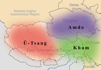
Kham (Tibetan: ཁམས, Wylie: khams, ZYPY: kam; Chinese: 康; pinyin: Kāng), is a historical region covering a land area largely divided between present-day Tibetan Autonomous Region and Sichuan province, with smaller portions located within Qinghai, Gansu and Yunnan provinces of China. During the Republic of China's rule over mainland China (1911–1949), most of the region was called Xikang Province (西康省). It held the status of "special administrative district" until 1939, when it became an official Chinese province. Its provincial status was nominal and without much cohesion, like most of China's territory during the time of Japanese invasion and civil war.
Kham is called by the natives of the region as: Tibetan: ཁམས་པ; Wylie: khams pa; Chinese: 康巴; pinyin: Kāngbā.
Contents
Geography
 Minya Konka range
Kham has a rugged terrain characterized by mountain ridges and gorges running from northwest to southeast, and collectively known as the Hengduan Mountains. Numerous rivers, including the Mekong, Yangtze, Yalong Jiang, and the Salween flow through Kham.
Under the modern administrative division of the People's Republic of China, Kham comprises a total of 50 contemporary counties, which have been incorporated into the Chinese provinces of Sichuan (16 counties), Yunnan (3 counties), and Qinghai (6 counties) as well as the eastern portion of the Tibet Autonomous Region (25 counties).
Ethnic groups
 Khampas - the inhabitants of Kham
Linguists and anthropologists refer to Kham as the 'Ethnic Corridor of Southwest China', as its vast and sparsely populated territories are inhabited by over 14 culturally and linguistically distinct ethnic groups. For reasons of simplicity, the Chinese government combines the various ethnic groups of Kham together with the Tibetans to form one big nationality, called the "Tibetan Nationality". There are, however, significant differences in traditions and beliefs—even physical appearance—between the peoples of Kham and Lhasa. At least one-third of Kham residents are speakers of Qiangic languages, a family of twelve distinct but interrelated languages that are not closely related to the Khams Tibetan language.
The people of Kham are reputed warriors.[citation needed]
History
Kham was traditionally referred to as Chushi Gangdruk, i.e. 'four rivers and six ranges'. The peoples of Kham have endured a tumultuous past, their sovereignty often encroached upon and marginalized by both Tibetans to the West and the Han Chinese to the East.
Kham was never controlled by a single king, but most of the chieftains revered the Dalai Lamas and often made contact with the Lhasa government. Kham was a patchwork of two dozen or more kingdoms, tribes, and chiefdoms that were constantly at war with each other. Since the collapse of the Tibetan Empire in the mid-9th century, the peoples of Kham had aggressively maintained their independence from invading nations. Local chieftains ruled their respective territories with hereditary titles bestowed by the Tibetan government. Chieftains were able to rule with a large degree of independence from both China and Tibet.[1]
In 1717, Dzungar tribes of Mongolia invaded Tibet, and a period of internal strife and civil war followed. The Kangxi emperor sent armies into the area for 20 years, and local leaders were forced to pledge their allegiance to the Qing Empire. In 1724, the regions of Amdo and Kham were made into the province of Kokonor, with parts of Eastern Kham incorporated into neighboring Chinese provinces.[2]
In the early 19th century, Gombo Namgye raised a rebellion in Nyarong, an area of Eastern Kham. He is reported to have taken control of Eastern Tibet, excepting Amdo. Residents of Derge and the Hor States appealed to both Lhasa and the Manchu government for help against Namgye. China was unable to take action, but Tibetan authorities sent an army in 1863, and defeated Namgye in 1865. Tibet then claimed Nyarong, Derge (or De-ge) and the Hor States north of Nyarong. This appears to have been accepted by the Manchu emperor.[3]
Tibetan control of the Batang region of Kham appears to have continued uncontested from an agreement made in 1726[4] until soon after the invasion of Tibet by Francis Younghusband in 1904, which alarmed the Qing rulers in China. They sent an imperial official to the region to begin reasserting Qing control, but the locals revolted and killed him. The Qing government in Beijing then appointed Zhao Erfeng, the Governor of Xining, "Army Commander of Tibet" to reintegrate Tibet into China. He was sent in 1905 (though other sources say this occurred in 1908)[5][6] on a punitive expedition and began destroying many monasteries in Kham and Amdo and implementing a process of sinification of the region:[7]
- "He abolished the powers of the Tibetan local leaders and appointed Chinese magistrates in their places. He introduced new laws that limited the number of lamas and deprived monasteries of their temporal power and inaugurated schemes for having the land cultivated by Chinese immigrants.
- Zhao's methods in eastern Tibet uncannily prefigured the Communist policies nearly half a century later. They were aimed at the extermination of the Tibetan clergy, the assimilation of territory and repopulation of the Tibetan plateaus with poor peasants from Sichuan. Like the later Chinese conquerors, Zhao's men looted and destroyed Tibetan monasteries, melted down religious images and tore up sacred texts to use to line the soles of their boots and, as the Communists were also to do later, Zhao Erfeng worked out a comprehensive scheme for the redevelopment of Tibet that covered military training reclamation work, secular education, trade and administration."[8]
In 1910, the Qing government sent a military expedition of its own to establish direct Chinese rule. They deposed the 13th Dalai Lama in an imperial edict and instigated a search for a new incarnation.[9] . The Dalai Lama then fled to British India in February 1910. While in India, the Dalai Lama became a close friend of Charles Alfred Bell, a British diplomatic officer stationed in Sikkim and a critic of Great Britain's policies in the region. "By going in and then coming out again, we knocked the Tibetans down and left them for the first comer to kick," wrote Bell later. The situation was soon to change, however, as, after the fall of the Qing dynasty in October 1911, Zhao's soldiers mutinied and beheaded him.[8]
The 13th Dalai Lama fled to British India in February 1910. The same month, the Chinese Qing government issued a proclamation deposing the Dalai Lama and instigating the search for a new incarnation.[10]
The official position of the British Government was it would not intervene between China and Tibet and would only recognize the de facto government of China within Tibet at this time.[11] Bell, in his history of Tibet, wrote of this time that "the Tibetans were abandoned to Chinese aggression, an aggression for which the British Military Expedition to Lhasa and subsequent retreat [and consequent power vacuum within Tibet) were primarily responsible".[11] Later, Britain defined the Indo-Tibetan border at the 1914 Simla Accord with the McMahon Line. China's delegation refused to agree to the line and still claims the land India received from Tibet as South Tibet, although the McMahon line remains the de facto border.
In 1932, an agreement signed between Chinese warlord Liu Wenhui and Tibetan forces formalized the partition of Kham into two regions: Eastern Kham, which was administered by Chinese forces, and Western Kham, which was administered by Tibet. Eastern Kham subsequently became the actual area of control of China's Xikang province. The border between eastern and western Kham is the Yangtze River - Dri Chu in Tibetan and Jinsha Jiang, or Chang Jiang respectively, in Chinese.
In 1950, following the defeat of the Kuomintang rulers of China by communist forces in the Chinese Civil War, the People's Liberation Army entered western Kham. Western Kham was then set up as a separate Qamdo Territory (昌都地区), then merged into Tibet Autonomous Region in 1965. Meanwhile, Xikang province, comprising eastern Kham, was merged into Sichuan province in 1955. The border between Sichuan and Tibet Autonomous Region has remained the Yangtze River. The northernmost region of Kham, Yushu, has been a part of Qinghai province since the 18th century.
See also
- Outline of Tibet
- Tibetan Resistance Since 1950
- Khams Tibetan language
- Xikang
- Kingdom of Derge
Footnotes
- ^ Richardson, Hugh E. (1984). Tibet and its History. Second Edition, Revised and Updated, pp. 28-68. Shambhala. Boston & London. ISBN 0-87773-376-7 (pbk)
- ^ Stein, R. A. (1972) Tibetan Civilization; translated by J. E. Stapleton Driver, p. 88. Stanford University Press, Stanford, California. ISBN 0-8047-0806-1 (cloth); ISBN 0-8047-0901-7 (paper).
- ^ "What is Tibet? Fact and Fancy". http://www.case.edu/affil/tibet/tibetanSociety/documents/What_is_Tibet_NEW.doc. Retrieved 2010-03-02.
- ^ Abbé Huc. The Land of the Lamas. Taken from: Travels in Tartary, Thibet and China, 1844-1846 by MM. Huc and Gabet, translated by William Hazlitt, p. 123.
- ^ "Ligne MacMahon."
- ^ FOSSIER Astrid, Paris, 2004 "L’Inde des britanniques à Nehru : un acteur clé du conflit sino-tibétain." [1]
- ^ "About Tibet: Later History"
- ^ a b Hilton, Isabel. (1999). The Search for the Panchen Lama. Viking. Reprint: Penguin Books. (2000), p. 115. ISBN 0-14-024670-3.
- ^ Smith (1996), p. 175
- ^ Smith (1996), p. 175
- ^ a b Bell (1924), p. 113
Further reading
- Thomas Laird: The Story of Tibet: Conversation With the Dalai Lama, Grove Press, New York, ISBN 978-0-8021-1827-1
- Andreas Gruschke: The Cultural Monuments of Tibet’s Outer Provinces: Kham, 3 vols. (2 published so far), White Lotus Press, Bangkok 2004. ISBN 974-480-049-6
- Tsering Shakya: The Dragon in the Land of Snows. A History of Modern Tibet Since 1947, London 1999, ISBN 0-14-019615-3
- Pamela Logan: Tibetan Rescue. The Extraordinary Quest to Save the Sacred Art Treasures of Tibet, Tuttle Publishing 2002, ISBN 0-8048-3421-0
External links
- Khampa Network
- Seven Days in Permitless Tibet Magazine article about traveling overland across Kham
Categories:
Wikimedia Foundation. 2010.


