- Ngari Prefecture
-
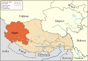
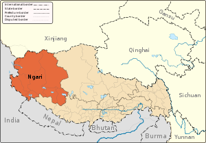 Ngari Prefecture in Tibet Autonomous Region
Ngari Prefecture (also: Ali Prefecture) (Tibetan: མངའ་རིས་ས་ཁུལ་, Wylie: mnga' ris sa khul; simplified Chinese: 阿里地区; traditional Chinese: 阿里地區; pinyin: Ālǐ Dìqū) is a prefecture of the Tibet Autonomous Region. Its capital is Gar County. Its regional headquarters is in the town of Purang. The biggest town is Ali. It includes part of the Aksai Chin area, a disputed region claimed by India but over which China exercises administrative control. The Xinjiang-Tibet Highway (新藏公路) passes through this area. There is a famous pre-historic culture site near the town of Rutog.
The heart of the ancient Tibetan Guge kingdom was once here. Later Ngari, along with Ü and Tsang composed Ü-Tsang, one of the traditional provinces of Tibet, the others being Amdo and Kham.
Ngari sits 4,500 meters above sea level in the northwest of Tibet, 1,600 kilometers from the regional capital Lhasa. The Gunsa Airport is expected to start operation on July 1, 2010, to become the fourth civil airport on the "Roof of the World". The other airports in Tibet are Gonggar Airport in Lhasa, Bamda Airport in Qamdo Prefecture and Nyingchi Airport. [1]
Contents
Subdivisions
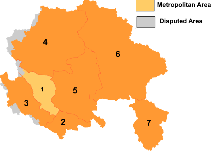
The prefecture is subdivided into seven county-level divisions: seven counties.
Map 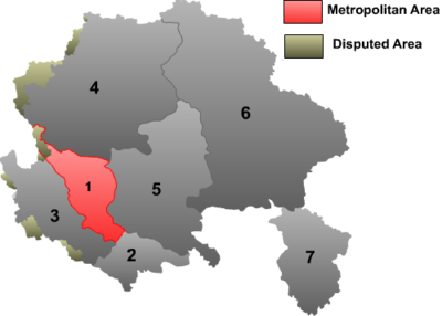
# Name Hanzi Hanyu Pinyin Tibetan Wylie Population (2003 est.) Area (km²) Density (/km²) 1 Gar County 噶尔县 Gá'ěr Xiàn སྒར་རྫོང་ sgar rdzong 10,000 13,179 1 2 Burang County 普兰县 Pǔlán Xiàn སྤུ་ཧྲེང་རྫོང་ spu hreng rdzong 10,000 24,602 0 3 Zanda County 札达县 Zhádá Xiàn རྩ་མདའ་རྫོང་ rtsa mda' rdzong 10,000 18,083 1 4 Rutog County 日土县 Rìtǔ Xiàn རུ་ཐོག་རྫོང་ ru thog rdzong 10,000 77,096 <1 5 Gê'gyai County 革吉县 Géjí Xiàn དགེ་རྒྱས་རྫོང་ dge rgyas rdzong 10,000 46,117 <1 6 Gêrzê County 改则县 Gǎizé Xiàn སྒེར་རྩེ་རྫོང་ sger rtse rdzong 20,000 135,025 <1 7 Coqên County 措勤县 Cuòqín Xiàn མཚོ་ཆེན་རྫོང་ mtsho chen rdzong 10,000 22,980 <1 Further reading
- Bellezza, John Vincent: Zhang Zhung. Foundations of Civilization in Tibet. A Historical and Ethnoarchaeological Study of the Monuments, Rock Art, Texts, and Oral Tradition of the Ancient Tibetan Upland. Denkschriften der phil.-hist. Klasse 368. Beitraege zur Kultur- und Geistesgeschichte Asiens 61, Verlag der Oesterreichischen Akademie der Wissenschaften, Wien 2008.
- Zeisler, Bettina. (2010). "East of the Moon and West of the Sun? Approaches to a Land with Many Names, North of Ancient India and South of Khotan." In: The Tibet Journal, Special issue. Autumn 2009 vol XXXIV n. 3-Summer 2010 vol XXXV n. 2. "The Earth Ox Papers", edited by Roberto Vitali, pp. 371-463.
See also
External links
Provincial level divisions of the People's Republic of China Provinces 
Autonomous regions Municipalities Special Administrative Regions Territorial disputes - Paracel, Spratly, Zhongsha Islands (see Paracels, Spratlys, & Zhongsha Iss. Authority)
- Pratas Islands
- Senkaku Islands
- South Tibet
- Taiwan, Kinmen & Matsu (see Legal status of Taiwan)
Towns and villages Categories:- Tibet
- Prefectures of Tibet
- Ngari Prefecture
- Himalayas
- Tibet geography stubs


Wikimedia Foundation. 2010.