- Nyingchi Prefecture
-
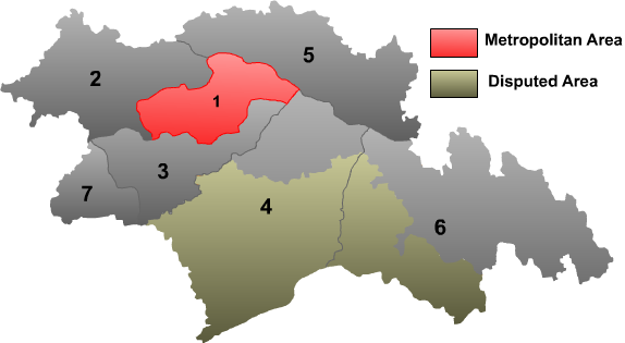
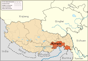 Nyingchi Prefecture in the Tibet Autonomous Region
Nyingchi Prefecture (also: Linzhi Prefecture) (Tibetan: ཉིང་ཁྲི་ས་ཁུལ་; Wylie: nying-khri sa khul; simplified Chinese: 林芝地区; traditional Chinese: 林芝地區; pinyin: Línzhī Dìqū) is a prefecture in southwestern Tibet Autonomous Region in western China. The Chinese government claims South Tibet, which is currently governed by India, as part of the prefecture.
Nyingchi Prefecture is the location of Buchasergyi Lakang Monastery.
Geography and landmarks
The prefecture contains the Namjagbarwa Peak, and the Yarlung Zangbo Great Canyon, located in Medog County, which attracts significant tourism and geoscientific and biological study to the area.
Approximately 90 kilometers west of Gongbo'gyamda County, is the alpine Basum Lake in the upper catchment area of the Ba River, the largest tributary of the Nyang River lying on average about 3,538 meters above sea level. The lake surface is on average about 3,538 meters above sea level. Covering an area of 25.9 square kilometers, the surrounding is populated by a diverse wildlife including leopards, Bears, goats, musk deer and Tibetan snow In 1997, the Basum Lake was listed by the World Tourist Organization as a top tourist attraction. The lake also contains an inlet with a Gelug monastery. East of Nyingchi County, is the Seche La Mountain, a mountain of the Nyainqentanglha Mountain Range, which forms part of the watershed of the Nyang River and the Polung Zangbo River. Benri La Mountain near the small town of Dagze is a known sacred site of the Tibetan Bon Sect. Considered by Tibetans as one of the four great holy mountains in Tibet, on every tenth day of the eighth month of the Tibetan calendar, a day of intense worshipping called "Nangbolhasoi," is performed (meaning "seeking for treasures from immortals.")
Bayi Town is the administrative seat of Nyingchi, located 406 kilometers east of Lhasa. The vicinity is known for its cypresses which can grow up to 30 meters.
The Nangpo Gully, located about 50 kilometers northwest from Gongbo'gyamda County, is one of the northern tributaries of the Nyang River and its upper stream is formed by the confluence of Yangwo, Gyixing and Boru streams. The area contains the hot springs the Nun's Hot Springs, the Lama's Hot Springs and the Boru Hot Springs and many old pine trees and cypresses, and caves. At the foot of the gully is the Yellow sect (Gelug) Bagar Monastery, which was built during the period of the Fifth Dalai Lama. The cave above the monastery contains murals of holy animals and Buddhist images, and below the cave is the famous Karst springs. show jade-red bear branches, forming a "Red Cloud Gully" of 5 kilometers. The cobbles in the bed of the stream look like scattered pearls, so this place is also called "Pearl Shoal." The scenes here are unique and beautiful.
Burqug Lamaling Monastery, located on the third terrace on the left bank of the lower reaches of the Nyang River.
Administrative Sub-divisions
The two counties of Zayü (察隅县) and Mêdog (墨脱县), collectively called South Tibet, are considered by the Chinese government to be under Chinese jurisdiction, however they are de facto under the control by India's state of Arunachal Pradesh.
Map 
# Name Hanzi Hanyu Pinyin Tibetan Wylie Population (2003 est.) Area (km²) Density (/km²) 1 Nyingchi County 林芝县 Línzhī Xiàn ཉིང་ཁྲི་ས་རྫོང་ nying khri rdzong 30,000 8,536 4 2 Gongbo'gyamda County 工布江达县 Gōngbùjiāngdá Xiàn ཀོང་པོ་རྒྱ་མདའ་རྫོང་ kong po rgya mda' rdzong 30,000 12,960 2 3 Mainling County 米林县 Mǐlín Xiàn སྨན་གླིང་རྫོང་ sman gling rdzong 20,000 9,507 2 4 Mêdog County 墨脱县 Mòtuō Xiàn མེ་ཏོག་རྫོང་ me tog rdzong 10,000 31,394 0 5 Bomê County 波密县 Bōmì Xiàn སྤོ་མེས་རྫོང་ spo mes rdzong 30,000 16,770 2 6 Zayü County 察隅县 Cháyú Xiàn རྫ་ཡུལ་རྫོང་ rdza yul rdzong 20,000 31,305 1 7 Nang County 朗县 Lǎng Xiàn སྣང་རྫོང་ snang rdzong 10,000 4,114 2 External links and sources
- Tibetinfor.com
- Nyingchi information and travel guides at Nyingchi.com
Provincial level divisions of the People's Republic of China Provinces 
Autonomous regions Municipalities Special Administrative Regions Territorial disputes - Paracel, Spratly, Zhongsha Islands (see Paracels, Spratlys, & Zhongsha Iss. Authority)
- Pratas Islands
- Senkaku Islands
- South Tibet
- Taiwan, Kinmen & Matsu (see Legal status of Taiwan)
Tibet Autonomous Region Topics Admin.
divisionsLhasa | Chengguan District · Lhünzhub County · Damxung County · Nyêmo County · Qüxü County · Doilungdêqên County · Dagzê County · Maizhokunggar County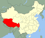 Tibet in China
Nagqu | Nagchu County · Lhari County · Biru County · Nyainrong County · Amdo County · Xainza County · Sog County · Baingoin County · Baqên County · Nyima County · Shuanghu Special District*
Qamdo | Qamdo County · Jomda County · Gonjo County · Riwoqê County · Dêngqên County · Zhag'yab County · Baxoi County · Zogang County · Markam County · Lhorong County · Banbar County
Nyingchi | Nyingchi County · Gongbo'gyamda County · Mainling County** · Mêdog County** · Bomê County · Zayü County** · Nang County**
Shannan | Nêdong County · Zhanang County · Gonggar County · Sangri County · Qonggyai County · Qusum County · Comai County · Lhozhag County · Gyaca County · Lhünzê County** · Cuona County** · Nagarzê County
Xigazê | Xigazê City · Namling County · Gyangzê County · Tingri County · Sa'gya County · Lhazê County · Ngamring County · Xaitongmoin County · Bainang County · Rinbung County · Kangmar County · Dinggyê County · Zhongba County · Yadong County · Gyirong County · Nyalam County · Saga County · Gamba County
Ngari | Gar County · Burang County · Zanda County · Rutog County · Gê'gyai County · Gêrzê County · Coqên County■ = Prefecture-level city ■ = Prefecture
* Not an official division ** Part of the South Tibet area, which is administered by India and claimed by the PRC.Nyingchi Prefecture, Tibet County-level divisions 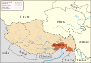
Geography Ba River · Nyang River · Pagsum Lake · Mount Nyainqentanglha
Towns and villages Coordinates: 29°34′37.20″N 94°29′02.40″E / 29.577°N 94.484°E
Categories:- Prefectures of Tibet
- Nyingchi Prefecture


Wikimedia Foundation. 2010.