- Cawarong
-
Cawarong (Chinese: 察瓦龙; Pinyin: Cháwǎlóng) is a village (村) in Zayü County, Tibet Autonomous Region of China.[1] It lies at an altitude of 2003 metres (6574 feet). Formerly known as Tsarung, it was traditionally a southern gateway and trade route into Tibet from Yunnan, forming part of the tea-horse road (Pinyin: Cha Ma Gu Dao 茶马古道). It is a very arid area with little rainfall. An unsealed road cut into the cliffs above the Nu River links it to Bingzhongluo in Yunnan. Cawarong is a major step on the Khora of the Khawa Karpo.
Coordinates: 28°30′N 98°24′E / 28.5°N 98.4°E
See also
- List of towns and villages in Tibet
Notes
- ^ (Chinese) Wu Zhenhua (武振华), Xizang Diming (西藏地名; Place Names in Tibet), p.65, Chinese Zangxue Press (中国藏学出版社) 1996, ISBN 7800572846
External links and references
Nyingchi Prefecture, Tibet County-level divisions 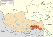
Geography Ba River · Nyang River · Pagsum Lake · Mount Nyainqentanglha
Towns and villages Categories:- Populated places in the Nyingchi Prefecture

Wikimedia Foundation. 2010.