- Matsu Islands
-
"Lienchiang County" redirects here. For the county of the People's Republic of China, see Lianjiang County.
Lienchiang County
連江縣
Abbreviation(s): Matsu (馬祖)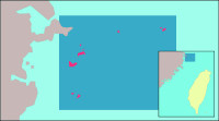
County seat Nangan Township Region Eastern Fujian County Magistrate Yang Suisheng (楊綏生) Cities 0 Townships 4 Area - Total 29.6055 km²
(25 of 25)- % water n/a % Population - Total 9,755 (December 2008)
(25 of 25)- Density 329.50/km² Symbols - County flower Hairy Bougainvillea (Bougainvillea glabra) - County tree none - County bird Chinese Crested Tern (Sterna bernsteini) Official websites wwww.matsu.gov.tw Matsu Islands Traditional Chinese 立祖列島 Simplified Chinese 马祖列岛 Transcriptions Mandarin - Hanyu Pinyin Mǎzǔ Lièdǎo - Tongyong Pinyin Mǎzǔ Lièdǎo - Wade–Giles Mat-su Lieh-tao - Yale Romanization Mǎdzǔ Lyèdǎu Lienchiang County Traditional Chinese 連江縣 Simplified Chinese 连江县 Transcriptions Mandarin - Hanyu Pinyin Liánjiāng Xiàn - Tongyong Pinyin Liánjiāng Siàn - Wade–Giles Lien-chiang Hsien - Yale Romanization Lyánjyāng Syàn Min - Hokkien POJ Lián-kang-kōan The Matsu Islands (simplified Chinese: 马祖列岛; traditional Chinese: 馬祖列島; pinyin: Mǎzǔ Lièdǎo; Fuzhou dialect: Mā-cū liĕk-dō̤ or less frequently, simplified Chinese: 马祖群岛; traditional Chinese: 馬祖群島; pinyin: Mǎzǔ Qúndǎo; Fuzhou dialect: 馬祖島 Mā-cū-dō̤) are a minor archipelago of 19 islands and islets in the Taiwan Strait administered as Lienchiang County (連江縣; Lièng-gŏng-gâing), Fujian Province of the Republic of China (ROC, commonly known as "Taiwan"). Only a small area of what is historically Lienchiang County is under the control of the ROC. The People's Republic of China (AKA "China") controls the part of the county on mainland China and has a separate administration for that jurisdiction, Lianjiang County (same name as Lienchiang in Chinese but romanized differently), which claims the entire archipelago to be its Mazu Township (媽祖鄉; Mā-cū-hiŏng).
They are named after the goddess Mazu. Kinmen is the other archipelago on the Fujian coast controlled by the ROC.
Contents
History
Fujianese Mainlanders started migrating to the islands during the Yuan Dynasty. Most people on Matsu came from Houguan (侯官) (today Changle County (長樂縣 Diòng-lŏ̤h-gâing), Fujian).
Some crewmen of Zheng He temporarily stayed on the islands. In early Qing Dynasty, pirates gathered here and residents temporarily left.
In contrast to Taiwan and Penghu, the Matsu Islands were not ceded to the Empire of Japan via the 1895 Treaty of Shimonoseki. Neither were they occupied by Japan as in the case of Kinmen during World War II.
After the Kuomintang (KMT) retreated to Taiwan in 1949, the ROC retained the part of Lienchiang County offshore (and the entire Kinmen County as well).
The phrase "Quemoy and Matsu" became part of U.S. political language in the 1960 U.S. presidential election. During the debates, both candidates, Richard Nixon and John F. Kennedy, pledged to use U.S. forces if necessary to protect the Republic of China from invasion by the People's Republic of China, the mainland, which the U.S. did not at that time recognize as a legitimate government. But the two candidates had different opinions about whether to use U.S. forces to protect the ROC's forward positions, Quemoy and Matsu, as well. In fact, Senator Kennedy stated that these islands - just a few miles off the coast of China and more than a hundred miles from Taiwan - were strategically indefensible and were not essential to the defense of Taiwan. On the contrary, Vice President Nixon maintained that, since Quemoy and Matsu were in the "area of freedom," they should not be surrendered to the Communists as a matter of "principle."[1]
In April 2003, the county government started considering changing the name to Matsu County to avoid confusion with the county of the same name on the mainland. Some locals opposed the name change because they felt it reflected a Democratic Progressive Party Taiwan Independence viewpoint.[2]
Townships
 Subdivision of Lienchiang county into townships
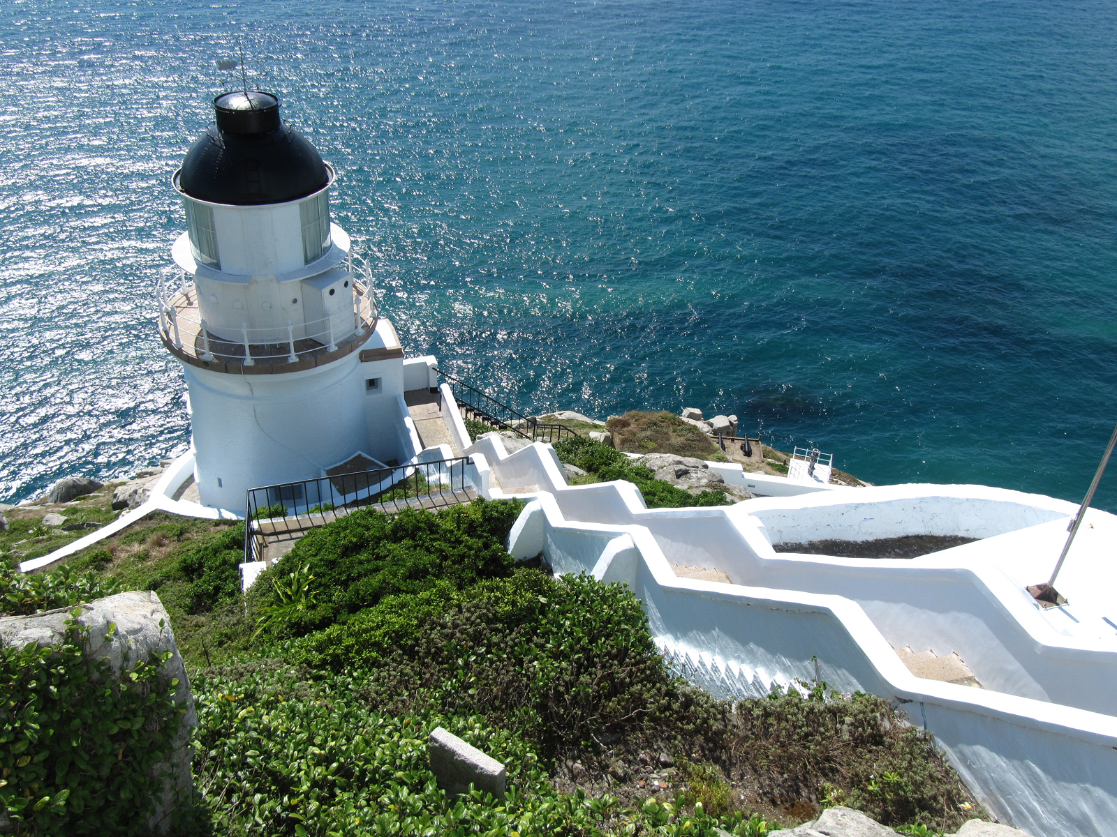
 Dongyong Lighthouse
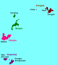
Lienchiang County (of the Republic of China) is currently divided into four townships:
- Nangan Township (南竿鄉; Nángān; literally "Southern Fishing Pole"; Fuzhou dialect: Nàng-găng-hiŏng)
- Beigan Township (北竿鄉; Běigān; literally "Northern Fishing Pole"; Fuzhou dialect: Báe̤k-găng-hiŏng)
- Juguang Township (莒光鄉; Jǔguāng; literally "Brilliance of the Ju Kingdom"; Fuzhou dialect: Gṳ̄-guŏng-hiŏng)
- Dongyin Township (東引鄉; Dōngyǐn; literally "Welcoming the East"; Fuzhou dialect: Dĕ̤ng-īng-hiŏng)
Altogether, there are 22 Lienchiang villages, which are further divided into 137 neighborhoods (鄰 lín).
All townships, except Juguang, are named after the largest island in its jurisdictional area, but most townships also include other islets.
Geography
The Matsu Islands include five major islands: Nangan, Dongju and Xiju (both in Juguang Township), Beigan, and Dongyin. Minor islands include Liang (亮島), Gaodeng (高登), Daqiu (大坵), and Xiaoqiu (小坵) - all belong to the Beigan Township.
- North: 26º18' N
- South: 25º56' N
- East: 120º1'20" E
- West: 119º51' E
Another set of coordinates: 119°51'-120°31' E, 25°55'-26°44' N.
Dongyin is the northernmost and Dongjyu is the southernmost.
- Dongyin is 100 nautical miles (190 km) from Keelung, Taiwan, 180 to the Penghu islands, and slightly over 10 nautical miles (19 km) from the Chinese Mainland.
- The soils are not ideal for farming.
- The highest point is on Beigan, 298 metres.
Areas:
- Nangan: 10.43 km²
- Beigan: 8.86 km²
- Dongyin: 4.35 km²
- Juguang islands: see Juguang
Average annual temperature is 18.6°C, with the lowest point being 1.3°.
The total number of islands and islets is 19.[2]
Demographics
The language spoken by Matsu residents is Fuzhou dialect (福州話), a dialect of Min Dong Language.
Chen (陳) is the most common surname, then Lin (林), Wang (王), Tsao (曹), and Liu (劉).
Several islands are not inhabited permanently, some of which are stationed by Republic of China soldiers.
Economy
Farm products include rice, sugar cane, tea plant, orange. Sea animals, such as fish, clams, and jellyfish, are also popular exports.
Tourism
One of the most promising resources for local economy is tourism. Lianjiang County Government is making great efforts to attract more visitors to the Matsu Islands, especially among foreigners.[3][4] In fact, Matsu islands are famous for their historical sites and beautiful scenery. Due to their size, traveling by motorized scooter is an ideal way to get around the main islands such as Nangan and Beigan. Both Islands have regular buses and taxis are also economical.
Both Nangan and Beigan have airports, but because the main airport is located in Nangan, travel between the islands is frequently done by boat. In fact, boats are the main form of transportation between the Matsu islands.
Nangan is the capital of Matsu and is famous for its mesmerizing granite tunnel as well as the Iron Fort. It has two interconnected main roads. Each road leads to different sites but because they are connected, it does not take long to visit all of the sites on the island.
The Bei-Hei tunnels are manmade granite tunnels that marvel visitors. One is located in Beigan while the other is located in Nangan. Both tunnels were amazing for their time, and took great effort to construct. The tunnel in Nangan was built in 1968. The completion of Bei-Hei tunnel took the effort of thousands of men. The 700 meter tunnel has a width of 10 meters and a height of 16 meters. It was completed in 820 days with shovels, spades and explosives; the tunnel also took the life of a platoon of soldiers. The tunnel was considered a military location and was not opened until 1990. The tunnel’s structure and precision still amazes visitors today and is a must see in Matsu.
The Iron Fort is located on the Southwest side of Nangan island. Located by a small cliff, it is a vulnerable spot for outside attacks or illegal smuggling of materials. With that in mind, the fort was built for defense. It is equipped with multiple machine-gun rooms and rudimentary living facilities. It is now open to the public, and although most of the equipment has been removed from the site, the site itself brings back a vivid image of what it was like for soldiers at that time.
Chin Be village is located in Beigan and was renowned for its style of architecture and history. Many of the buildings were built from the late 19th century to early 20th century. However the village, once occupied by over one hundred households, was abandoned by the fishermen due to hard living conditions; the village was reduced to less than 20 households. Luckily by the 1960s, it was restored by the local government. Chin Be is situated beside a beach, overlooking China. It is ideal for an early morning or late evening stroll.
Other famous sites include the 88 Tunnel distillery, Matsu temple, Fu-Au seaport, and many different kinds of monuments.[5][6]
Natural reserves
Since 1990, the county controls the Matsu Islands Bird Sanctuary (馬祖列島燕鷗保護區), which spreads across eight islands and islets in Nangan, Beigan and Tongyin Townships. It contains 30 species in 15 orders, mostly gulls and terns. In 2000, four pairs of the critically endangered Chinese Crested Tern, previously thought to be extinct, were discovered nesting on the Matsu Islands, giving them global conservation importance.
There are also mosses and ferns rare or absent elsewhere in the ROC.[7]
Connection to the goddess
Matsu, though named after the goddess Matsu, is written with a different character that has a different tone. But the Matsu Islands are not the birthplace of the goddess as the human Lin Muoniang - Meizhou Island is — but her death place (on a seaport named after her on Nangan Island).[8]
The Matsu Nangan Heavenly Empress Palace (馬祖南竿天后宮), a temple dedicated to the goddess, contains the sarcophagus of Lin Muoniang. It is, however, not as popular as the Meizhou temple.
Most Taiwanese pilgrims to Meizhou start off their journey in the Matsu Islands because they are the closest Taiwan-controlled base to Meizhou, which is controlled by the PRC.
See also
- Administrative divisions of the Republic of China
- Township (Republic of China)
- List of cities in the Republic of China (Republic of China)
- List of islands of the Republic of China
References
- ^ Norris, Robert B. (November 29, 2010). "Quemoy and Matsu: a historical footnote revisited". American Diplomacy. http://findarticles.com/p/articles/mi_7052/is_2010_Nov_29/ai_n56470328/?tag=content;col1. Retrieved 2011-02-08.
- ^ a b Sandy Huang (April 6, 2003). "Cases of mistaken identity perplexing Lienchiang County". Taipei Times. http://www.taipeitimes.com/News/front/archives/2003/04/06/201011. Retrieved January 14, 2009.
- ^ "Matsu Island opens doors to tourists". Taiwan Today. March 3, 2010. http://taiwantoday.tw/ct.asp?xItem=97102&ctNode=413. Retrieved February 8, 2011.
- ^ "Matsu islands aim to attract more overseas tourists". Taipei Times. August 29, 2010. http://www.taipeitimes.com/News/taiwan/archives/2010/08/29/2003481579. Retrieved February 8, 2011.
- ^ "Nangan". Matsu National Scenic Area. http://www.matsu-nsa.gov.tw/User/Article.aspx?a=29&lang=2. Retrieved February 8, 2011.
- ^ "Beigan". Matsu National Scenic Area. http://www.matsu-nsa.gov.tw/User/Article.aspx?a=28&lang=2. Retrieved February 8, 2011.
- ^ "Climate, Flora and fauna". Matsu National Scenic Area. http://www.matsu-nsa.gov.tw/User/Article.aspx?a=25&l=2. Retrieved February 8, 2011.
- ^ "History and customs". Matsu National Scenic Area. http://www.matsu-nsa.gov.tw/User/Article.aspx?a=22&l=2. Retrieved February 8, 2011.
External links
- Matsu travel guide from Wikitravel
- Lienchiang County Government Official Website
- Military importance from www.globalsecurity.org
- Smaller map (from CNN)
- Name change: Taipei Times article
- Matzu Scenic Area
- Satellite image of the Nangan and Beigan islands by Google Maps
 Administrative divisions of the Republic of China
(Otherwise known as Taiwan). Special municipalities 
Taiwan Province CitiesFujian Province Kinmen · LienchiangSee also: Free Area of the Republic of China. Cities and townships in the Taiwan strait islands of the Republic of China County seats are in Bold Taiwan 
Fukien Jinning · Lieyu · WuqiuLienchiangLanguage Chinese-speaking nations and regions Coordinates: 26°09′04″N 119°55′38″E / 26.15111°N 119.92722°E
Categories:- Ports and harbours of the Republic of China
- Territorial disputes of the People's Republic of China
- Territorial disputes of the Republic of China
- Matsu


Wikimedia Foundation. 2010.