- Liancourt Rocks
-
"Dokdo" redirects here. For other uses, see Dokdo (disambiguation)."Takeshima" redirects here. For other uses, see Takeshima (disambiguation).
Liancourt Rocks Disputed islands
Other names: Dokdo, Takeshima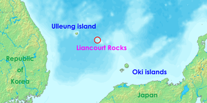
Location of the Liancourt Rocks in the Sea of Japan (East Sea) between South Korea and Japan Geography 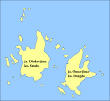
Location Sea of Japan (East Sea) Coordinates 37°14′30″N 131°52′0″E / 37.24167°N 131.866667°E Total islands 90 (37 permanent land) Major islands East Islet, West Islet Area 0.18745 square kilometres (46.32 acres)
East Islet: 0.0733 square kilometres (18.1 acres)
West Islet: 0.08864 square kilometres (21.90 acres)Highest point unnamed location on West Islet
169 metres (554 ft)Administered by  South Korea
County Ulleung County, North Gyeongsang Claimed by  Japan
JapanTown Okinoshima, Shimane South KoreaCounty Ulleung County, North Gyeongsang  North Korea
County Ullŭng County, North Kyŏngsang[citation needed] Demographics Population 2 + 43 support personnel (in rotation) Ethnic groups Korean The Liancourt Rocks, also known as Dokdo or Tokto (독도/獨島, literally "solitary island") in Korean or Takeshima (たけしま/竹島, literally "bamboo island") in Japanese,[1] are a group of small islets in the Sea of Japan (East Sea). Sovereignty over the islets is disputed between Japan and South Korea.[2] The islets are currently administered by South Korea, which has its Coast Guard stationed there.[3]
The Franco-English name of the islets derives from Le Liancourt, the name of a French whaling ship which came close to being wrecked on the rocks in 1849.[4] Both the Korean[3] and Japanese[5] names have changed over time, a testament to the historical confusion over the subject which led to today's heated dispute.
The Liancourt Rocks consist of two main islets and 35 smaller rocks. The total surface area of the islets is 0.18745 square kilometres (46.32 acres), with the highest elevation of 169 metres (554 ft) found at an unnamed location on the west islet.[6] Two Korean citizens—an octopus fisherman and his wife—are permanent residents on the islets. A small Korean police detachment, administrative personnel, and lighthouse staff are stationed in non-permanent supporting positions on the islets.[7]
South Korea administers the islets as Dokdo-ri,[8] Ulleung-eup, Ulleung County, North Gyeongsang Province. Japan classifies them as part of Okinoshima, Oki District, Shimane Prefecture.
The islets lie in rich fishing grounds which could also contain large gas deposits.[9]
Contents
Geography
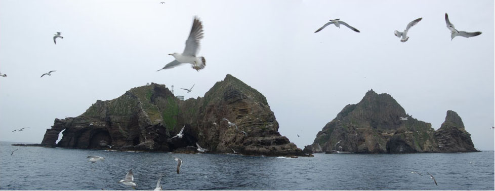
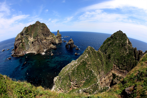
 A panorama image of the Liancourt Rocks,
Left side: Eastern Island (lighthouse located here);
Right side: Western Island.The Liancourt Rocks consist of two main islets and numerous surrounding rocks. The two main islets, called Seodo (서도/西島, "Western Island") and Dongdo (동도/東島, "Eastern Island") in Korean, and Otokojima (男島, "Male Island") Onnajima (女島, "Female Island") in Japanese, are 151 metres (495 ft) apart.[6] The Western Island is the larger of the two, with a wider base and higher peak, while the Eastern Island offers more usable surface area.
Altogether, there are about 90 islets and reefs,[10] volcanic rocks formed in the Cenozoic era, more specifically 4.6 to 2.0 million years ago. A total of 37 of these islets are recognized as permanent land.[10]
The total area of the islets is about 187,450 square metres (46.32 acres), with their highest point at 169 metres (554 ft) on the West Islet.[6] The West Islet is about 88,640 square metres (21.90 acres); the East Islet is about 73,300 square metres (18.1 acres).[10]
The West Islet consists of a single peak and features many caves along the coastline. The cliffs of the East Islet are about 10 to 20 metres (33 to 66 ft) high. There are two large caves giving access to the sea, as well as a crater.
In 2006, a geologist reported that the islets formed 4.5 million years ago and are quickly eroding.[11]
Distance, elevation, and visibility
Liancourt Rocks are located at about 131°52´ East longitude and about 37°14´ North latitude.[10] The West Islet is located at 37°14′31″N 131°51′55″E / 37.24194°N 131.86528°E and the East Islet is located at 37°14′27″N 131°52′10″E / 37.24083°N 131.86944°E.
Liancourt Rocks are 215 kilometres (134 mi) (117 nmi) from mainland Korea and 211 kilometres (131 mi) (114 nmi) from Japan proper.[12]
Distance, elevations, and weather conditions all affect visibility of the islets.
The nearest Korean island, Ulleung-do, is 87 kilometres (54 mi), 47 nmi, from which Liancourt Rocks are visible on a clear day in the absence of fog in the vicinity of Liancourt Rocks.[13][not in citation given] [14][15] The nearest Japanese island, Oki Islands, is 157 kilometres (98 mi), 85 nmi, from which Liancourt Rocks are not visible on any day of the year regardless of weather conditions.[16][17][18]
Climate
Due to their location and extremely small size, the Liancourt Rocks sometimes have harsh weather. At times, ships are unable to dock because of strong northwestern winds in winter.[6] Overall, the climate is warm and humid, and heavily influenced by warm sea currents. Precipitation is high throughout the year (annual average—1,324 millimetres or 52.1 inches), with occasional snowfall. Fog is also a common sight. In the summer, southerly winds dominate. The water around the islets is about 10 °C (50 °F) in spring, when the water is coolest. It warms to about 25 °C (77 °F) in August.
Ecology
 A view from one of the rocks on a calm day.
The islets are volcanic rocks, with only a thin layer of soil and moss.[10] About 49 plant species, 107 bird species, and 93 insect species have been found to inhabit the islets, in addition to local marine life with 160 algal and 368 invertebrate species identified.[19] Although between 1,100 and 1,200 litres of fresh water flow daily, desalinization plants have been installed on the islets for human consumption because existing spring water suffers from guano contamination.[20] Since the early 1970s trees and some types of flowers were planted.[6] According to historical records, there used to be trees indigenous to Liancourt Rocks, which have supposedly been wiped out by overharvesting and fires caused by bombing drills over the islets.[21][22] A recent investigation, however, identified ten spindle trees aged 100–120 years.[23][24] The presence of trees is required under international law for the islets to be recognized as natural islands rather than reefs.[7]
Demographics and economy
There are two permanent Korean citizens, Kim Sung-do (김성도) and Kim Shin-yeol (김신열), living on the islets, who make a living from fishing. In addition to these residents, there are 37 South Korean police officers (독도경비대/獨島警備隊) who take residence on guard duty. There are also three Ministry of Maritime Affairs and Fisheries personnel, and three lighthouse keepers living on the islets in rotation. In the past, several fishermen also lived on the islets temporarily.[25]
For many years, civilian travel was subject to Korean government approval because the islet group is designated as a nature reserve. Tourist boats carrying 1,597 visitors were allowed to land in 2004. Since mid-March 2005, more tourists have been allowed to land; up to 70 tourists are permitted at any one time. One ferry provides rides to the islets every day, and reportedly has a long waiting list.[26] Around 60% of visitors on the ferry are allowed to land in port on the East Islet while the rest are given a tour around the islets. En route to Liancourt Rocks, the ferry shows an animated film featuring a giant robot warding off Japanese invaders.[27] Tour companies charge around 350,000 Korean won per person (approx. 250 US dollars as of 2009[update]).[7]
Construction
Under South Korean administration, the Liancourt Rocks have undergone heavy construction. Today, the islands house a lighthouse, a helicopter pad, a large South Korean flag visible from the air, a post box,[28] a staircase, and police barracks.[27] In 2007, two desalinization plants were built capable of producing 28 tons of clean water every day.[20] Both of the major Korean telephone companies have installed cell phone towers on the islets.[29]
Pollution and environmental destruction
There is a serious concern for pollution in the seas surrounding Liancourt Rocks. The sewage water treatment system established on the islets has malfunctioned and sewage water produced by inhabitants of Liancourt Rocks such as South Korean Coast Guard and lighthouse staff is being dumped directly into the ocean. Significant water pollution has been observed; sea water has turned milky white, sea vegetation is progressively dying off, and calcification of coral reefs is spreading. The pollution is also causing loss of biodiversity in the surrounding seas. In November 2004, eight tons of malodorous sludge was being dumped into the ocean every day.[30] Efforts have since been made by both public[31] and private[32] organizations to help curb the level of pollution surrounding the Rocks.
Role in Japan–Korea relations
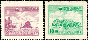
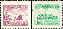 South Korea has issued stamps depicting the Liancourt Rocks since 1954.
The Liancourt Rocks are a point of heated contention, alongside other Japan–Korea disputes. The Japanese Ministry of Foreign Affairs considers its position "inalterable".[33][34] South Korea, for its part, maintains a nationwide educational program which sends the students 62 elementary, middle, and high schools on field trips to the rocks on a regular basis. The government has also written a textbook about the rocks, intended to be used in elementary schools across the country, and manages a year-round national educational tour.[35] When Japan's Shimane prefecture announced a "Takeshima Day" in 2005, Koreans reacted with demonstrations and protests throughout the country, extreme examples of which included a mother and son slicing off their own fingers, and a man who set himself on fire.[36] In 2006, five Korean "Dokdo Riders" embarked on a world tour to raise international awareness of the dispute.[36] Another notable protest featured South Koreans decapitating pheasants in front of the Japanese Embassy.[27]
Dispute
Main article: Liancourt Rocks disputeAlthough claimed by both Korea and Japan, Liancourt Rocks are currently administered by the Republic of Korea. Both nations' claims extend back at least several hundred years. Significant arguments supported by a variety of historical evidence have been presented by both parties, which have been challenged by counter-arguments with varying degrees of success.[37][38] North Korea supports South Korea's claim.[39][40]
References
- ^ Staff Seoul and Tokyo hold island talks BBC, 20 April 2006
- ^ Charles Scanlon "South Koreans vent fury at Japan" BBC Online, 18 March 2005
- ^ a b "Liancourt Rocks / Takeshima / Dokdo / Tokto", Globalsecurity
- ^ Kirk, Donald (2008-07-26). "Seoul has desert island dreams". Asia Times Online. http://www.atimes.com/atimes/Japan/JG26Dh01.html.
- ^ Shin, Yong-Ha. "Disputes over Ullungdo and Tokdo at the End of the 17th Century". http://www2.gol.com/users/hsmr/Content/East%20Asia/Korea/Dokto_Island/History/Shin_Yong-ha_3.html.
- ^ a b c d e Introducing Dokdo Cyber Dokdo
- ^ a b c Life in Dokdo Cyber Dokdo
- ^ "Act 1395 amending Chapter 14-2, Ri-Administration under Ulleung County, Local Autonomy Law, Ulleung County (울릉군리의명칭과구역에관한조례 [개정 2000. 4. 7 조례 제1395호)"]. http://www.elis.go.kr/newlaib/laibLaws/h1126/laws.jsp?regionId=47940. "Pursuant to Act 1395 amending Chapter 14-2, Ri-Administration under Ulleung County, Local Autonomy Law, Ulleung County, passed March 20, 2000, enacted April 7, 2000, the administrative designation of Dokdo addresses as 42 to 76, Dodong-ri, Ulleung-eup, Ulleung County, North Gyungsang Province, is changed to address 1 to 37, Dokdo-ri, Ulleung-eup, Ulleung County, North Gyungsang Province." "2000년 4월 7일 울릉군조례 제1395호로 독도리가 신설됨에 따라 독도의 행정구역이 종전의 경상북도 울릉군 울릉읍 도동리 산42~76번지에서 경상북도 울릉군 울릉읍 독도리 산1~37번지로 변경 됨."[1]
- ^ "Island row hits Japanese condoms", BBC News, 2008-07-27, http://news.bbc.co.uk/2/hi/asia-pacific/7511065.stm
- ^ a b c d e Gyongsangbuk-do (2001). Cyber Dokdo. Retrieved 9 January 2006.
- ^ "독도, 일본보다 빠른 속도로 침몰하고 있다", The Korea Times, 2006/12/01. 손영관교수 `독도ㆍ울릉도 `침몰하고 있다``, JoongAng Ilbo, 2006/12/01.
- ^ "The Issue of Takeshima". Ministry of Foreign Affairs of Japan. http://www.mofa.go.jp/region/asia-paci/takeshima/index.html. Retrieved 2011-04-01.
- ^ "울릉도 민가 지붕위로 ‘또렷한 독도’, photo included" (in Korean). 2009-03-25. http://news.naver.com/main/read.nhn?mode=LSD&mid=sec&sid1=103&oid=025&aid=0002002860.
- ^ BAEK In-ki, SHIM Mun-bo, Korea Maritime Institute. A study of Distance between Ulleungdo and Dokdo and Ocean Currents (울릉도와 독도의 거리와 해류에 관한 연구) Dec 2006,. ISBN 9788979983401. http://library.kmi.re.kr/w03_01e.asp?gs_DType=m&gs_DControlNo=52190. pp. 20-22: "Kawakami Kenzo presented a mathematical formula for calculating visible distance... with the highest elevation of Dokdo at 157 metres above sea level... supposing point of view at 4 metres above sea level (deck height on an common vessel being 2.5 metres and height of observer's eyes at 1.5 metres giving 4.0 metres), he obtained a visible distance of 30.305 nautical miles (56.124 km). Lee Han-key (1969), taking a more recent measurement of elevation of Dokdo ... at 174 metres above sea level, and elevation of Ulleung Is' Mt Seong'in at 985 metres above sea level, obtained a visible distance of 93.17 nautical miles (172.55 km)... demonstrated that any observer, facing Dokdo from Ulleung Is at an elevation greater than 120 metres, can sight Dokdo." (가와카미 겐조(川上健三; 1966)는 시달거리(視達距離, visible distance) 공식을 제시하고... 독도... 157m로 보고 眼高를 4m(높이 2.5m의 갑판 상에서 1.5m의 사람이 선 경우)로 가정하여, 독도를 볼 수 있는 범위를 약 30.305해리 (56.124km)로 계산하였다. 이에 따라 가와카미는 울릉도와 독도는 50해리 떨어져 있으므로 울릉도에서는 독도를 볼 수 없다고 주장하였다. 이에 대해 이한기(1969)는 서도... 174m로 하고, 울릉도... 985m를 적용하여 93.17해리라는 시달거리를 계산하였다... 울릉도에서 120 m 만 올라가면 독도를 볼 수 있다는 것을 보였다.)
- ^ ibid. pp. 43-44: "It is not any clear day that Dokdo is visible from Ulleung Is; local weather around the Dokdo area must not be foggy... The minor islets in the immediate neighborhood of Ulleung proper are visible on any day of the year provided the fog is not overly dense to be impenetrable. Dokdo, in contrast, is just so far that it is only visible on 'a clear day, and when any fog is absent near Dokdo." (오늘날 울릉도에서 독도를 볼 수 있는 날은 그냥 맑은 날이 아니라 '독도 부근에 해무가 없는 맑은 날'이다... 울릉도 주위의 섬들은 해무가 아주 짙게 낀 날을 제외하고 일년 중 대부분 볼 수 있다. 그러나 독도는 '독도 주변에 해무가 없는 맑은 날'에만 보일 만큼 떨어져 있다.)
- ^ National Geographic Atlas of the World, 7th edition. pp. 103-104. This map of Japan and Korea shows the highest point of all islands of the Oki Archipelago on Dogo (島後) Island with peak at 608 metres (1,995 ft) above sea level.
- ^ At 377 metres (1,237 ft) lower than Ulleung Is' highest peak, the visible distance from the highest peak of Oki's Dogo Island towards an island of height 174 metres (571 ft) (Lee Han-key's figure for the West Islet of Liancourt Rocks) is considerably less than 93.17 nautical miles (172.55 km). The actual distance from Oki Iss to Liancourt Rocks is 85 nautical miles (157 km). Kawakami's visible distance formula requires minimum elevation of observer on top of Dogo Is at 755 metres (2,477 ft); observer must be standing at 147 metres (482 ft) above the highest Dogo peak to make a sighting of Liancourt Rocks.
- ^ Joong'ang Daily. "A 1454 Dokdo Description Confirmed (옛 문헌에 나온 독도기록은 사실이었다)". http://article.joins.com/article/article.asp?Total_ID=3231930. "Japanese [historical] records .... are devoid of any instance of sighting Dokdo (Liancourt Rocks) with the eye [from a Japanese territory]." (일본 측 문헌에는 ... 독도를 눈으로 확인했다는 기록조차 없다.)
- ^ "A comprehensive survey of the natural ecosystems of Liancourt Rocks (synopsys) 독도 자연생태계 정밀조사결과(요약)". http://epic.kdi.re.kr/epic/epic_view.jsp?num=81035&menu=1.
- ^ a b Korea.net. "Doosan pours big drink for Dokdo residents" June 12, 2007.
- ^ BAEK In-ki, SHIM Mun-bo, Korea Maritime Institute. "op. cit.". http://library.kmi.re.kr/w03_01e.asp?gs_DType=m&gs_DControlNo=52190. p. 48: There are records attesting to the existence of trees [on Liancourt Rocks] in the past. (과거에는 독도에도 수목이 있었다는 기록이 있기는 하다.)
- ^ LEE Kyu Tae, Chosun Daily (June 27, 2003). "(pseud.)The Trees of Liancourt Rocks". http://www.dokdomuseum.go.kr/board/gongi4/view.php?tbname=gongi4&number=1050&page=46&xxnum=685.독도의 나무는 본래 무쇠처럼 단단했던 것으로 알려지고 있다. 오랫동안 나무 하나 자라기 힘든 돌섬으로 알려져 있었지만 독도에도 나무가 자라고 있었던 것이다. 〈조선일보〉 이규태 씨에 따르면 남해의 거문도에는 독도에서 꺾어온 나무로 만들었다는 가지 방망이며 가지홍두깨가 있었다고 한다. 또한 배를 만들 때 이 독도에서 꺾어온 나무로 나무못을 만들어 박았다 한다. 이규태 씨는 그의 칼럼에서 다음과 같이 적고 있다. '30여 년 전 거문도에서 80대의 노 어부 박운학 옹을 만난 적이 있는데, 그에 의하면 구한말 당시 거문도 어부들은 울릉도에 가서 아름드리 거목을 베어 배를 만들고, 또 그 재목을 뗏목으로 만들어 끌고 온다고 했다. 해변에 움막을 치고 배를 만드는데 쇠못을 구할 수가 없어 독도까지 가서 나무를 베어와 그 나무못으로 조립을 했다한다. 왜냐하면 이 바위섬에서 자란 나무는 왜소하지만 몇 백 년 몇 천 년 풍운에 시달려 목질이 쇠만큼 단단해져 있기 때문이라 했다. 독도나무를 베어오면서 물개 한 마리를 잡아와 기름을 짜고 그 기름으로 밤을 밝혔다.' 그렇다면 독도에서 이 나무가 없어진 이유는 무엇일까? 이규태 씨는 '문경새재 박달나무가 방망이 홍두깨로 다 나갔듯이 독도 나무도 나무못이나 방망이 홍두깨로 모조리 베어져 나갔을 것'이라고 추정한다. 그런데 울릉도 주민들의 생각은 조금 다르다. 그들은 독도의 나무가 없어진 주범으로 미 공군의 독도폭격을 들고 있다. '엄청난 폭탄을 퍼부었는데 독도에 풀 한포기 살아있겠어요? 폭격당시 울릉도에서도 보일 정도로 독도 쪽에서 불꽃과 연기가 피어올랐으니까요. 나무는 그 때 모조리 타버렸죠.
- ^ "Indigenous Spindle Tree Colony Found on Liancourt Rocks 독도 자생 사철나무 군락 첫 발견". http://www.korean.net/blog/main/index.jsp?blID=leehayo&ccID=260&SN=22.
- ^ "Liancourt Rock Spindle Trees Over 100 Year Olds 독도 자생 사철나무 100년 이상 된 자생식물". http://www.dokdocenter.org/dokdo_news/index.cgi?action=detail&number=7489&thread=19r02.
- ^ Dokdo in History Dokdo Research Institute
- ^ Michael Ha. "A Unique Trip to Dokdo — Islets in the News". The Korea Times. August 26, 2008.
- ^ a b c Choe Sang-Hun. " A fierce Korean pride in a lonely group of islets". International Herald Tribune. August 28, 2008
- ^ Vladivostok News report
- ^ Korea.net
- ^ "독도 오수정화시설이 동해바다 오염 주범?". Imaeil. http://www.imaeil.com/sub_news/sub_news_view.php?news_id=42521&yy=2007.
- ^ "Three-Month Cleanup for Dokdo's Marine Garbage Starts from June 2 독도 바다쓰레기 청소 6월2일부터 석달간". http://news.naver.com/main/read.nhn?mode=LSD&mid=sec&sid1=102&oid=003&aid=0002703591.
- ^ "나무 심고 오물 줍고…아름다운 ‘독도 사랑’". http://www.imaeil.com/sub_news/sub_news_view.php?news_id=27210&yy=2010.
- ^ The Issue of Takeshima, Ministry of Foreign Affairs of Japan
- ^ The Truth Is... Dokdo is Korean Territory 2009-03-10, Dokdo Research Institute
- ^ Kuminilbo. "The current state of Dokdo education" (日 독도 침탈 점점 노골화 되는데 우리는 우리 땅 제대로 가르치나). August 2011.
- ^ a b Charles Burress. "'Dokdo Riders' on world tour for rocks". San Francisco Chronicle. April 1, 2006.
- ^ Fahim, Kareem (20 March 2009). "On Plastic Bags, an Old and Distant Dispute". New York Times. http://www.nytimes.com/2009/03/21/nyregion/21islands.html?_r=1&hp. Retrieved 21 March 2009.
- ^ McCurry, Justin (18 August 2010). "Rocky relations between Japan and South Korea over disputed islands". The Guardian. http://www.guardian.co.uk/world/2010/aug/18/japan-south-korea-disputed-islands.
- ^ http://www.dokdo-takeshima.com/
- ^ North Korea actually sides with South Korea over something
External links
 Media related to Liancourt Rocks at Wikimedia Commons
- Takeshima (Shimane Prefectural Government, Japan)
- Dokdo Research Institute (Korea)
- Mark Selden, Small Islets, Enduring Conflict: Dokdo, Korea-Japan Colonial Legacy and the United States, The Asia-Pacific Journal Vol 9, Issue 17, No 2, April 25, 2011.
Coordinates: 37°14′30″N 131°52′00″E / 37.24167°N 131.8666667°E
Categories:- Anti-Japanese sentiment in Korea
- Anti-Korean sentiment in Japan
- Disputed islands
- Disputed territories in Asia
- Islands of the Sea of Japan
- Japan–South Korea border
- Liancourt Rocks
- Territorial disputes of Japan
- Territorial disputes of South Korea


Wikimedia Foundation. 2010.