- Oki Islands
-
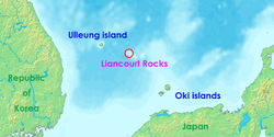 Location map
 Oki Islands
Oki Islands (隠岐諸島 Oki-shotō, or 隠岐群島 Oki-guntō) are a group of islands in the southwestern part of the Sea of Japan and belong to Japan.
Contents
Geography
The Oki Islands are situated between 40 to 80 kilometers north of the coast of Honshū.
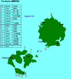
The islands are of volcanic origin and have a total area of 346,1 km2. The group consists of 16 islands and the highest elevation is Mount Damanji-San at about 608 meters[1] on Dōgo.
The largest and inhabited islands are:
- Dōgo (島後), main island, about 243 km2, northeast off the subgroup of the so-called Dōuzen Islands[2](島前) with
- Chiburi-shima (知夫里島), about 14 km2
- Nakano-shima (中ノ島), about 33 km2
- Nishino-shima (西ノ島), about 56 km2
The population is about 24,500 inhabitants spread over the four administrative areas of:
- Okinoshima-chō (Okinoshima-town), includes all of Dōgo Island and close by islets as Okina-shima, Obana-shima, Tsuname-shima, Shijiki-jima and Ombe-shima, population about 17.000, Japan considers the disputed Liancourt Rocks to be a part of Okinoshima.
- Chibu-mura (Chibu-village), includes all of Chiburi-shima and close by islets as Okaga-shima, Shimazu-jima, Asa-shima and Kami-shima, population about 800.
- Ama-chō (Ama-town), includes all of Nakano-shima and close-by islets as Omori-jima and Matsu-shima, population about 2,600.
- Nishinoshima-chō (Nishinoshima-town), includes all of Nishino-shima and close-by islets as Hoshikami-jima, Futamata-jima and O-kazuro-shima, population about 3,900.[3]
The islands make up the Oki-shichō (Oki District) and are part of Shimane Prefecture. The island group is also part of the"Daisen Oki Kokuritsu Kōen (Daisen-Oki National Park).[4]
Transportation
The airport Oki Kūkō (Oki Airport, airport code "OKI") lies on the southeastern part of Dōgo[5] and provides air service to Osaka International Airport (Itami, "ITM") and Izumo Airport ("IZO").
The islands can be reached by ferries from harbours like Sakaiminato, Shichirui and Kaga on the mainland.[6]
Weather
- Summers (June–August) average around 30 degrees Celsius plus humidity. There usually is a strong sea breeze. The sea waves during the summer rarely exceed 2 meters.
- Autumn (September–November) is temperate. It begins to rain more often and the waves begin to grow. The Rainbow ferry stops operating in November.
- Winters (December to the end of February) are relatively mild. Temperatures rarely drop below freezing. Also, due to the warming influence of the sea, Oki does not get much snow. What snow there is does not lie for long because the ground is not cold enough. The ferry is more likely to be canceled due to high waves, but it is still possible to leave the island.
- Spring (March–May) is generally regarded as the best season. There are many opportunities for viewing cherry blossoms on Oki during the spring. The Rainbow starts running in March.
History
It is uncertain as to when the islands were discovered; they are mentioned in the Kojiki and the Nihon Shoki.[7]
Already under the Nara period the islands were used as an exile for persons from the mainland.[8]
From the Kamakura period the islands were administrated as "Oki no kuni" (Oki Province) and primarily governed by the shugo (governor) from Izumo Province.
In 1198 Emperor Go-Toba (tennō) was sent to exile to Dōgo where he stayed until his death in 1239.[9] Between 1331 and 1333 tennō Go-Daigo was exiled to Nishino-shima.[10]
From the Muromachi period the islands were ruled successively by the Sasaki clan, the Yamana clan and the Kyogoku clan until the Amago clan to the Sengoku period.
Under the Edo period the Tokugawa family took control over the islands and they were put under the direct control of the Shogun through a governor. Later they became part of the Matsue Domain. During that time the islands were a stopover point for trading boats traveling to and from Asia.[11]
After the Meiji Restoration which introduced a succession of reforms to restructure the Japanese state, the islands first became part of the Tottori Prefecture in 1871 and were transferred to the Shimane Prefecture in 1881.[12]
On October 1, 2004, the town of Saigō and the villages of Fuse, Goka and Tsuma were administratively merged into the town of Okinoshima even though the townships still exist as separate towns.
References
External links
- The Oki Islands
- Map of the Oki Islands
- View of the Oki Islands
- Japan National Tourist Organization site
- The National Park
Coordinates: 36°09′17″N 133°09′09″E / 36.15472°N 133.1525°E
Categories:- Islands of Japan
- Islands of the Sea of Japan
- Visitor attractions in Shimane Prefecture
- Archipelagoes of Japan


Wikimedia Foundation. 2010.