- Daitō Islands
-
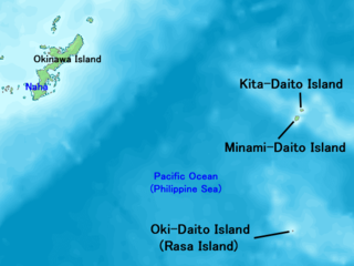 Map of Daito Islands
Daitō Islands (大東諸島 Daitō Shotō, Okinawan: Ufuagari; formerly the Borodino Islands) are three islands that lie about 217 miles (349 km) east of Okinawa. From north to south, the islands are:
Island name Kanji Romaji Area Population Kitadaitō 北大東島 Kita Daitō-jima 12.71 km² 700 Minami Daitō 南大東島 Minami Daitō-jima 30.57 km² 1,400 Oki Daitō 沖大東島 Oki Daitō-jima 1.147 km² 0 44.427 km² 2,100 - Data from 2004 Nov 20, 08:55 version of Japanese Wikipedia
All of the islands were uninhabited until the Meiji period, when people from other parts of Japan arrived. [1][2]
Contents
Islands grouping
- Ryūkyū/Nansei Islands
- Ryūkyū Shotō (Okinawa Prefecture)
- Daitō Islands
- Ryūkyū Shotō (Okinawa Prefecture)
Kita, minami, and oki means, respectively, "north," "south," and "offshore" while daitō means "great east."
Administration
The Daitō Islands form two municipalities of the Shimajiri District (島尻郡; -gun) of Okinawa Prefecture:
Uninhabited Oki Daitō island is part of Kitadaitō municipality, although located closer to Minami Daitō island.
History of the European sightings of the Daitō Islands
- There can be little doubt that the two small ‘Islas sin Probecho’, sighted by the Spanish navigator Pedro de Unamuno on 28 July 1587, are the Borodinos.
- The island of Amsterdam, which can be found to the west of Malabrigo on the maps of Quast, Martini, Sanson, and Nolin, according to Dahlgren, appears for the first time on a map of 1635. It was still searched for unsuccessfully by Beechey in 1827 and is clearly a longitudinal misplacement of Rasa, i.e., Oki Daitō-jima.
- Doubtless the ‘Breskens-Eylant’ discovered on the Dutch expedition of Maarten Gerritszoon Vries (in the Castricum) and Hendrik Corneliszoon Schaep (in the Breskens) on 8 May 1643 at 24°43 'N and 151°31' 30" E of Teneriffa ( 135°01 '30" E of Gr.), a low lying little island about c. 1.5 mylen (scarcely 2.8 km) long, is likewise identical with Isla Rasa, now Oki Daitō-jima (24°28' N; 131°11 'E). On Quast’s chart, which was also used on the Vries expedition, the island of ‘Malabrigo’ is situated 21 mylen to the west of ‘Breskens-Eylant’. In the ‘Daghregister’ of the Batavia port authority for 14 December 1643, on Vries’s voyage back, this discovery is called ‘Malabriga.’
- On an 1817 London chart, at c. 24°45 N; 134°10 E, is the entry ‘I. Dolores 1773’, which doubtless goes back to a sighting from a Spanish Manila galleon on her way from the Philippines to New Spain. We know that in 1773 the Spanish vessel Nuestra Señora de Consolación with Felipe Tompson as pilot sailed from Manila to California via New Guinea. On that voyage Helen Reef, Ngatik, and Oroluk in the Caroline Islands were sighted. Tompson’s southern route may not go against a sighting of the Daitos in the same year, but indicates that he initially tried to pursue the same course as his compatriot Francisco Antonio Maurelle seven years later, in 1780/81,77 a course which eventually was abandoned in favour of the traditional route.
- On a trading voyage aboard the Felice from Whampoa (Canton) to the northwest coast of America, the British captain John Meares on 4 and 5 April 1788 sighted three islands, which were believed to be a new discovery and called the ‘Grampus Isles’. Notwithstanding the considerable longitudinal difference of 14°30 and 14°55 30 , respectively, these Grampus Islands were Rasa (Oki Daitō-jima) and the Borodinos (Minami Daitō-jima and Kita Daitō-jima).
- Kendrick Island (24°35 N; 134°00 E) is a further longitudinal misplacement of Rasa. The earliest chart on which to find it dates from 1805. The name probably refers to either John Kendrick senior, who from the second half of 1789 until his death in December 1794 was busy in the maritime regions in question (further trading voyages of his vessel Lady Washington continued until 1796) or John Kendrick junior, who in July 1789 entered the Spanish service in Nootka Sound and as ‘Don Juan Kendrick’ ‘was sent to Spain in 1796 … had been a skillful pilot in the galleon service’. As John Kendrick junior was on the Northwest Coast for the fur trade (as a supercargo on the Eliza) in 1799, his active time in Spanish service, during which he could have encountered Kendrick Island, is between 1789 and 1796. A contingent sighting must have taken place between the second half of 1789 and 1796, either on a trading voyage to or from East Asia or on the Manila galleon route from the Philippines to New Spain (Mexico).
- According to Krusenstern, who refers to an Arrowsmith chart, the Bishop Rocks, lying at 25°20 N; 131°15 E, were discovered in 1796 or 1799 (the data are inconsistent) by Captain Bishop in the Nautilus. However, 1797 was the only year the Nautilus was east of the Ryukyu Islands, on her way from Macao to Kamchatka (16 June — 25 August 1797). It must have been during that voyage — any time between 6 and 31 July — that these rocks, presumably from afar, were sighted, which can be identified from their position with Minami Daitō-jima, if not both Minami Daitō-jima and Kita Daitō-jima (the Borodino Islands) as a whole were perceived as ‘rocks’.
- Another sighting of Rasa Island occurred on 8 May 1807, by Joseph-Ce´sar de Bourayne, commander of the French frigate La Canonnie're, on the way from Cavite to Acapulco. The supposed discovery, whose position was fixed at 24°30 N; 130°18 30 E, was christened ‘Ile de la Canonnière’.
- The Western names that stuck to the Daito Islands for more than 150 years were given in 1815 and in 1820: in 1815 Oki Daitō-jima was re-sighted by the last Manila galleon, the Spanish frigate San Fernando de Magallanes, and was called ‘Isla Rasa’, i.e. flat island; the position was fixed at 24°26 '40" N; 131°03' 46" E of Gr; and on 20 June 1820 (st. v.; 2 July 1820 st. n.) Minami Daitō-jima and Kita Daitō-jima were re-sighted by the Russian Navy’s Lieutenant Sachar Ivanovič Ponafidin, who called them (Ostrova Borodino, Borodino Islands) after his ship of the Russian-American Company. The positions fixed by him were 25°50'N; 131°12 E for the southern and 26°02 N; 131°15 E for the northern island respectively.
- ‘The brig Nile, of Boston, Captain Robert Bennet Forbes, in her passage from Canton to the Sandwich Islands, in August, 1825, passed two islands, the southernmost in lat. 25°42 N.; long. 131°13 E.; and the northern one in lat. 25°53 N.; long. 131°17 E. by good observations, and two chronometers’, clearly a re-sighting of the Borodinos.
Bibliography
- Welsch, Bernhard: Was Marcus Island discovered by Bernardo de la Torre in 1543?; in: Journal of Pacific history, Vol. 39, No. 1; 2004, pp. 109-122
References
- ^ 島の歴史 (History of the island) from Minamidaito village official website. Retrieved on 2007-01-15.
- ^ 島の歴史 - 無人島時代 - (History of the island - Desert island times) from Kitadaito village official website. Retrieved on 2007-01-15.
Coordinates: 25°50′34″N 131°14′26″E / 25.84278°N 131.24056°E
Categories:- Islands of Okinawa Prefecture
- Archipelagoes of Japan
Wikimedia Foundation. 2010.