- Siachen Glacier
"see
Siachen conflict for the military conflict over this area" Infobox Glacier | glacier_name = Siachen Glacier
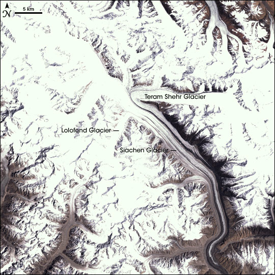
caption = Satellite imagery of the Siachen Glacier
type = Mountain glacier
location =Ladakh ,Kashmir ,India /Pakistan
coordinates =
area =
length = 70 km (43 mi)
thickness =
terminus =
status = Disputed. India currently controls the Siachen Glacier (since 1984)The Siachen Glacier is located in the eastern
Karakoram range in theHimalaya Mountains along the disputedIndia -Pakistan border at approximately coord|35.5|N|77.0|E|type:glacier. It is the longestglacier in the Karakoram and second longest in the world's non-polar areas. [ Siachen Glacier is 70 km long; Tajikistan'sFedchenko Glacier is 77 km long. The second longest in the Karakoram Mountains is the Biafo Glacier at 63 km. Measurements are from recent imagery, supplemented with Russian 1:200,000 scale topographic mapping as well as the 1990 "Orographic Sketch] It ranges from an altitude of 5,753 m (18,875 ft) above
sea level at its source at Indira Col (pass) on the China border to its snout at 3,620 m (11,875 ft)The Siachen Glacier lies south of the great watershed that separates
China from theIndian subcontinent in the extensively glaciated portion of theKarakoram that is sometimes called the "Third Pole." The 70 km (43.5 mile) long Siachen glacier lies between theSaltoro Ridge line immediately to the west and the mainKarakoram range to the east. TheSaltoro Ridge originates in the north from the Sia Kangri peak on the China border in the Karakoram range. The crest of the Saltoro Ridge's altitudes range from 5,450 to 7,720 m (17,880 to 25,330 feet). The major passes on this ridge are, from north to south, Sia La at 5,589 m (18,336 ft), Bilafond La at 5,450 m (17,880 ft), and Gyong La at 5,689 m (18,665 ft) The average wintersnowfall is 10.5 m (35 ft) and temperatures can dip to -50 degreesCelsius (-58 degreesFahrenheit ).Geography
Naming
In spite of the severe climate, the word 'Siachen' ironically means 'the place of wild
rose s', a reference some people attribute to the abundance of Himalayanwildflower s found in the valleys below the glacier, but which specifically refers to the thorny wild plants which grow on the rocky outcrops. The naming of the glacier, or at least its currency, is due toTom Longstaff .Rivers
The glacier's melting waters are the main source of the
Nubra River , which drains into theShyok River . The Shyok in turn joins theIndus River , thus the glacier is a major source of the river Indus.Global warming has had one of its worst impacts here in the Himalayas with the glaciers melting at an unprecedented rate and monsoon rains now appearing north of the mountains. The volume of the glacier has been reduced by 35 percent over the last twenty years and military activity since 1984 has also been blamed for much of the degradation of the glacier. [ [http://www.zeenews.com/articles.asp?aid=345084&sid=ENV&ssid=26 Zee News - Siachen glacier melting fast due to military activity: study ] ]Conflict Zone
The glacier is the highest battleground on earth, where
India andPakistan have fought intermittently sinceApril 13 ,1984 . Both countries maintain permanent military personnel in the region at a height of over convert|6000|m. The site is a prime example ofmountain warfare .Both sides have been wishing to disengage from the costly military outposts but after the
Kargil War in 1999, India has backed off from withdrawing in Siachen, wary that the Kargil scenario could play out again if they vacate their Siachen Glacier posts without any official confirmation of their positions.During her tenure as
Prime Minister of Pakistan , MsBenazir Bhutto , visited the area west of Gyong La, making her the first premier from either side to get to the Siachen region. OnJune 12 ,2005 ,Prime Minister Manmohan Singh became the first Indian Prime Minister to visit the area, calling for a peaceful resolution of the problem. In the previous year, thePresident of India ,Abdul Kalam became the firsthead of state to visit the area.India based
Jet Airways plans to open a chartered service to the glacier's nearest airlink, theThoise airbase , mainly for military purposes. Pakistan's PIA flies tourists andtrekkers daily toSkardu , which is the jumping off point forK2 , the world's second highest point just 33 kilometers (20.5 miles) northwest of the Siachen area, although bad weather frequently grounds these scheduled flights.Since September 2007, India has opened up mountaineering and trekking expeditions to the forbidding glacial heights. The expeditions are also meant to show to the international audience that Indian troops hold "almost all dominating heights" on the important Saltoro Ridge and, to show that Pakistani troops are not within convert|15|mi|km of the convert|43.5|mi|km|-1|adj=on Siachen Glacier. [ [http://timesofindia.indiatimes.com/India_opens_Siachen_to_trekkers/articleshow/2363583.cms India opens Siachen to trekkers]
Times of India 13 Sep 2007] Despite protests from Pakistan, India maintains that it doesn't need Pakistan's approval to send trekkers to Siachen, in what it says is essentially an Indian territory. [ [http://timesofindia.indiatimes.com/India_hits_back_at_Pak_over_Siachen_issue/articleshow/2376852.cms India hits back at Pak over Siachen issue]Times of India 17 Sep 2007]See also
*
List of glaciers Notes
References
*
V.R. Raghavan , "Siachen: Conflict Without End", Viking, New Delhi, 2002
* [http://washtimes.com/upi-breaking/20050418-071954-5399r.htm Analysis: Peace may return to Siachen] -The Washington Times
* [http://www.time.com/time/asia/covers/501050711/story.html TIME Asia's cover story on Siachen Glacier (July 11 , 2005)]
* "Heights of Madness: One Woman's Journey in Pursuit of a Secret War" by Myra MacDonald, published by Rupa. The first full account of the Siachen war to be told from the Indian and Pakistani sides.External links
* [http://www.youtube.com/watch?v=2NPANLHtQGE Video about the Conflict in the Siachen area and its consequences]
* [http://www.uvm.edu/~envprog/k2peacepark.htm Siachen Peace Park Initiative]
* [http://blankonthemap.free.fr Blankonthemap] The Northern Kashmir WebSite
* [http://outside.away.com/outside/features/200302/200302_siachen_1.html Outside magazine article about Siachen battleground]
*BBC News report: [http://news.bbc.co.uk/1/hi/world/south_asia/4581615.stm Nuclear rivals in Siachen talks] ;May 26 , 2005
* [http://www.siachen.ch Siachen - A War for ice - An awarded documentary on the Siachen War]
* [http://www.rediff.com/news/2005/jun/16athale.htm Why Siachen Matters?]
Wikimedia Foundation. 2010.