- Mudanjiang
-
Mudanjiang
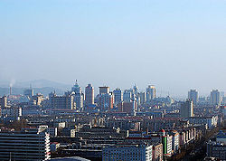
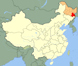
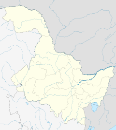
牡丹江— Prefecture-level city — 牡丹江市 Mudanjiang City (red) in Heilongjiang province (orange) and China Location of the city centre in Heilongjiang Coordinates: 44°33′N 129°38′E / 44.55°N 129.633°ECoordinates: 44°33′N 129°38′E / 44.55°N 129.633°E Country People's Republic of China Province Heilongjiang Area – Prefecture-level city 40,435 km2 (15,612 sq mi) – Urban 1,608 km2 (620.9 sq mi) – Metro 1,608 km2 (620.9 sq mi) Elevation 233 m (764 ft) Population (2010 census) – Prefecture-level city 2,798,723 – Density 69.2/km2 (179.3/sq mi) – Urban 805,584 – Urban density 501/km2 (1,297.5/sq mi) – Metro 805,584 Time zone China standard time (UTC+8) Licence plates 黑C Mudanjiang (Chinese: 牡丹江; pinyin: Mǔdānjiāng; Manchu: Mudan bira ᠮᡠᡩ᠋ᠠᠨ ᠪᡳᡵᠠ) is a prefecture-level city in Heilongjiang province of the People's Republic of China. The administrative seat of the prefecture resides in Mudanjiang City. It was called Botankou when it was under Japanese occuption. It serves as a regional communications hub with a railway junction and an international airport connecting with several major Chinese cities as well as Seoul, Korea. Mudanjiang is also an important border city, located only 248 km from Vladivostok, Russia. In 2007 Mudanjiang had a GDP of RMB 42.1 billion with a 13.3% growth rate.
Its population is 2,798,723 at the 2010 census whom 805,584 live in the built up area made of 4 urban districts.
Contents
Administrative divisions

# Name Hanzi Hanyu Pinyin Population (2003 est.) Area (km²) Density (/km²) 1 Aimin District 爱民区 Àimín Qū 230,000 359 641 2 Dong'an District 东安区 Dōng'ān Qū 180,000 566 318 3 Yangming District 阳明区 Yángmíng Qū 160,000 358 447 4 Xi'an District 西安区 Xī'ān Qū 210,000 325 646 5 Muling City 穆棱市 Mùlíng Shì 330,000 6,094 54 6 Suifenhe City 绥芬河市 Suífēnhé Shi 60,000 427 141 7 Hailin City 海林市 Hǎilín Shì 440,000 9,877 45 8 Ning'an City 宁安市 Níng'ān Shì 440,000 7,870 56 9 Dongning County 东宁县 Dōngníng Xiàn 210,000 7,368 29 10 Linkou County 林口县 Línkǒu Xiàn 450,000 7,191 63 Geography
Mudanjiang Climate chart (explanation) J F M A M J J A S O N D 4.7−11−235.5−5−18113−92614054217912514121281810927176021935130131−107.9−8−19Average max. and min. temperatures in °C Precipitation totals in mm Source: CMA [1] Imperial conversion J F M A M J J A S O N D 0.213−90.222−10.43816157332.170453.677564.882644.380622.470481.455320.534150.318−2Average max. and min. temperatures in °F Precipitation totals in inches Mudanjiang is located in southeastern Heilongjiang province, and is also the province's southernmost prefecture. Neighbouring prefectures are:
It also borders Russia's Primorsky Krai to the east. The average elevation in the prefecture is 230 metres (755 ft), with the terrain primarily consisting of mountains and hills. The east of the prefecture begins to ascend to the Changbai Mountains, while the central parts belong to the Hegu Basin. The lowest part of the prefecture is Suifenhe City, bordering Russia, at a minimum elevation of 86.5 metres (283.8 ft), while the highest point is Zhangguangcai, at 1,686.9 metres (5,534 ft).
Under the Köppen climate classification, Mudanjiang features a monsoon-influenced, humid continental climate (Dwa) with hot, humid summers and very cold winters. Its winters are dry and bitterly cold, with a 24-hour average in January of only −17.3 °C (0.9 °F), yet the city see little precipitation during this season and is often sunny. Moreover, winter temperatures are far warmer than much of the rest of the province, and the city's basin location helps protect it from biting winds. Summers can be hot, with a July mean temperature of 22.3 °C (72.1 °F). Summer is also when most of the year's rainfall occurs. Spring and autumn constitute brief transition periods with variable wind directions.
Climate data for Mudanjiang City (1971−2000) Month Jan Feb Mar Apr May Jun Jul Aug Sep Oct Nov Dec Year Average high °C (°F) −10.5
(13.1)−5.4
(22.3)3.2
(37.8)13.7
(56.7)20.9
(69.6)25.2
(77.4)27.9
(82.2)26.6
(79.9)21.0
(69.8)12.6
(54.7)1.1
(34.0)−8
(18)10.7 Average low °C (°F) −22.6
(−8.7)−18.4
(−1.1)−9
(16)0.4
(32.7)7.3
(45.1)13.6
(56.5)17.6
(63.7)16.5
(61.7)8.7
(47.7)0.0
(32.0)−9.7
(14.5)−18.8
(−1.8)−1.2 Precipitation mm (inches) 4.7
(0.185)5.5
(0.217)10.5
(0.413)25.6
(1.008)53.8
(2.118)90.6
(3.567)121.4
(4.78)108.9
(4.287)59.7
(2.35)35.2
(1.386)13.2
(0.52)7.9
(0.311)537.0
(21.142)% humidity 69 64 55 53 56 69 75 77 73 65 65 70 65.9 Avg. precipitation days (≥ 0.1 mm) 5.0 5.5 6.5 8.5 12.9 15.9 14.8 13.9 11.0 8.5 6.8 5.8 115.1 Sunshine hours 162.4 180.2 228.4 218.2 237.3 221.1 215.8 208.3 206.6 195.6 156.8 136.8 2,367.5 Source: China Meteorological Administration [1] Tourism
Named after the Mudan River, the region's premier tourist attraction is Jingpo Lake famous for its craggy limestone cliffs (similar to those of Guilin) and its turquoise waters containing Ericton fish and fresh water coral. Jingbo Lake is the only lava-dammed lake caused by volcanic eruption in China. Other sites include the National Forest Park and the Skee Field by Mudan Mountain, and the Breeding Center for the Siberian Tiger. Besides lamb hotpot, fish feast and gluten cake, the best local dishes also include hazel mushrooms and venison. Most of them are derived from Northeast China or Korean culinary styles. The fish feast and the stewed dishes are among the most famous delights.[2]
References
- ^ a b "中国地面国际交换站气候标准值月值数据集(1971-2000年)" (in Simplified Chinese). China Meteorological Administration. http://cdc.cma.gov.cn/shuju/index3.jsp?tpcat=SURF&dsid=SURF_CLI_CHN_MUL_MMON_19712000_CES&pageid=3. Retrieved 2010-11-20.
- ^ Profiles of China Provinces, Cities and Industrial Parks
External links
- http://ch-info.erina.or.jp/English/He/Mudan/mudanjiang.htm
- http://www.china.org.cn/english/travel/50995.htm
- http://wikitravel.org/en/Mudanjiang
Heilongjiang topics General Geography Cities • Greater Khingan mountain range • Lesser Khingan mountain range • Wanda Mountains • Huma River • Muling River • Naoli River • Songhua River • Nen River • Mudan River • Amur RiverEducation Visitor attractions Heilongjiang Province county-level divisions Harbin: Daoli District · Nangang District · Daowai District · Xiangfang District · Pingfang District · Songbei District · Hulan District · Acheng District · Shuangcheng City · Shangzhi City · Wuchang City · Yilan County · Fangzheng County · Bin County · Bayan County · Mulan County · Yanshou County · Tonghe County
Qiqihar: Longsha District · Jianhua District · Tiefeng District · Ang'angxi District · Fularji District · Nianzishan District · Meilisi Daur District · Nehe City · Longjiang County · Yi'an County · Tailai County · Gannan County · Fuyu County · Keshan County · Kedong County · Baiquan County
Hegang: Xingshan District · Xiangyang District · Gongnong District · Nanshan District · Xing'an District · Dongshan District · Luobei County · Suibin County
Shuangyashan: Jianshan District · Lingdong District · Sifangtai District · Baoshan District · Jixian County · Youyi County · Baoqing County · Raohe County
Jixi: Jiguan District · Hengshan District · Didao District · Lishu District · Chengzihe District · Mashan District · Hulin City · Mishan City · Jidong County
Daqing: Sartu District · Longfeng District · Ranghulu District · Datong District · Honggang District · Zhaozhou County · Zhaoyuan County · Lindian County · Dorbod Mongol Autonomous County
Yichun: Yichun District · Nancha District · Youhao District · Xilin District · Cuiluan District · Xinqing District · Meixi District · Jinshantun District · Wuying District · Wumahe District · Tangwanghe District · Dailing District · Wuyiling District · Hongxing District · Shangganling District · Tieli City · Jiayin County
Mudanjiang: Aimin District · Dong'an District · Yangming District · Xi'an District · Muling City · Suifenhe City · Hailin City · Ning'an City · Dongning County · Linkou County
Jiamusi: Qianjin District · Xiangyang District · Dongfeng District · Jiaoqu District · Tongjiang City · Fujin City · Huanan County · Huachuan County · Tangyuan County · Fuyuan County
Qitaihe: Taoshan District · Xinxing District · Qiezihe District · Boli County
Heihe: Aihui District · Bei'an City · Wudalianchi City · Nenjiang County · Xunke County · Sunwu County
Suihua: Beilin District · Anda City · Zhaodong City · Hailun City · Wangkui County · Lanxi County · Qinggang County · Qing'an County · Mingshui County · Suileng County
Da Hinggan Ling: Jiagedaqi District · Songling District · Huzhong District · Xinlin District · Huma County · Tahe County · Mohe CountyCategories:- Cities in Heilongjiang
Wikimedia Foundation. 2010.


