- Nikolayevsk-on-Amur
-
Nikolayevsk-on-Amur (English)
Николаевск-на-Амуре (Russian)- Inhabited locality - 
 Nikolayevsk-on-Amur
Coordinates: 53°08′N 140°44′E / 53.133°N 140.733°ECoordinates: 53°08′N 140°44′E / 53.133°N 140.733°E 
Coat of arms Administrative status Country Russia Federal subject Khabarovsk Krai Administrative center of Nikolayevsky District[citation needed] Municipal status Urban okrug Nikolayevsk-on-Amur Urban Okrug[citation needed] Mayor[citation needed] Alexander Kosinov[citation needed] Statistics Population (2002 Census) 28,492 inhabitants[1] Time zone VLAST (UTC+11:00)[2] Founded 1850[citation needed] Postal code(s) 682460[citation needed] Dialing code(s) +7 42135[citation needed] Official website Nikolayevsk-on-Amur (Russian: Никола́евск-на-Аму́ре; simplified Chinese: 庙街; traditional Chinese: 廟街; pinyin: Miàojiē) often romanized as Nikolayevsk-na-Amure, is a town and the administrative center of Nikolayevsky District of Khabarovsk Krai, Russia located on the Amur River close to its liman in the Pacific Ocean. Population: 28,492 (2002 Census);[1]
Contents
Geography and climate
The town is situated on the left bank of the Amur, 80 km from where it flows into the Amur estuary, 977 km north of the regional capital Khabarovsk, and 582 km from the Komsomolsk-on-Amur railway station. It is the closest significant settlement to the Tatar Strait separating the mainland from Sakhalin.
Nikolayevsk-on-Amur has a borderline humid continental climate (Köppen Dfb), almost cold enough to be a subarctic climate (Dfc). Precipitation is not as low in the winter as over most of Siberia since the coast in on the fringe of influence from the Aleutian Low. The near-maritime location only marginally (5˚C or 9˚F) moderates the winters compared to interior Siberia, but makes the summers noticeably cool (especially in May and June) though the Oyashio fogs are less prevalent than on Sakhalin itself and sunshine hours therefore rather longer.
Climate data for Nikolayevsk-on-Amur Month Jan Feb Mar Apr May Jun Jul Aug Sep Oct Nov Dec Year Record high °C (°F) 0.3
(32.5)5.7
(42.3)12.6
(54.7)19.6
(67.3)30.2
(86.4)34.3
(93.7)34.1
(93.4)35.3
(95.5)28.9
(84.0)22.5
(72.5)11.4
(52.5)2.8
(37.0)35.3
(95.5)Average high °C (°F) −18.2
(−0.8)−13.6
(7.5)−5.9
(21.4)2.8
(37.0)10.4
(50.7)19.2
(66.6)22.0
(71.6)21.3
(70.3)16.0
(60.8)6.5
(43.7)−6.4
(20.5)−15.9
(3.4)3.3 Daily mean °C (°F) −22.5
(−8.5)−18.8
(−1.8)−11.9
(10.6)−2.2
(28.0)4.7
(40.5)13.0
(55.4)16.7
(62.1)15.8
(60.4)10.5
(50.9)1.8
(35.2)−10.5
(13.1)−19.8
(−3.6)−1.8 Average low °C (°F) −26.1
(−15.0)−23
(−9.4)−17.2
(1.0)−6.4
(20.5)0.6
(33.1)7.7
(45.9)12.3
(54.1)11.5
(52.7)6.2
(43.2)−1.8
(28.8)−14.1
(6.6)−23.2
(−9.8)−6 Record low °C (°F) −47.2
(−53.0)−45.9
(−50.6)−37.6
(−35.7)−8.8
(16.2)−11.9
(10.6)−3.8
(25.2)1.3
(34.3)0.6
(33.1)−6
(21.2)−25.1
(−13.2)−34
(−29.2)−44.2
(−47.6)−47.2
(−53.0)Precipitation mm (inches) 31.1
(1.224)31.3
(1.232)32.6
(1.283)37.9
(1.492)49.9
(1.965)39.7
(1.563)72.2
(2.843)82.0
(3.228)88.2
(3.472)79.7
(3.138)50.6
(1.992)45.7
(1.799)640.9
(25.232)Avg. precipitation days 5.8 6.2 5.9 7.1 7.9 5.7 8.1 10.0 10.8 10.0 8.2 7.6 93.3 Sunshine hours 130.2 161.0 232.5 210.0 232.5 234.0 238.7 204.6 183.0 142.6 132.0 93.0 2,194.1 Source no. 1: pogoda.ru.net[3] Source no. 2: Hong Kong Observatory[4] History
Medieval and early-modern history
In the late Middle Ages, the people living along the lower course of the Amur (Nivkh, Oroch, Evenki) were collectively known in China as the "wild Jurchen". The Yuan Dynasty Mongols sent expeditions to this area with an eye toward using the region as a base for attack on Japan, or for defending against the Sakhalin Ainus. According to the History of Yuan, in 1264 the Nivkhs recognized the Mongol suzerainty. In 1263, the Mongols set up the "Command Post of the Marshal of the Eastern Campaign" (Chinese: 東征元帥府, Dongzheng Yuanshuai Fu) near the modern village of Tyr, some 100 km upstream from today's Nikolayevsk. At roughly the same time a shrine was built on the Tyr Rock (Тырская скала).[5][6]
From 1411 to 1433, the Ming eunuch Yishiha (亦失哈), a man of Haixi Jurchen origin, led four large missions to win over the allegiance of the "Jurchen" tribes along the Sunggari and Amur rivers. During this time, the Yongning Temple (永宁寺, Yongning Si) was constructed at Tyr, and stelae with inscriptions erected.[5]
The Russian city
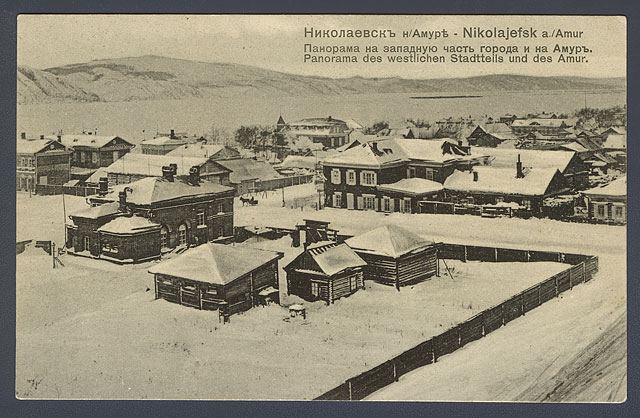
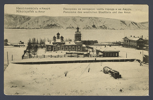
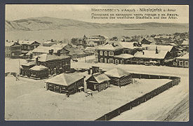 View of Nikolayevsk, ca. 1900.
 View of Nikolayevsk, ca. 1900.
The Russian settlement, likely preceded by the Manchu village of Fuyori,[7] was founded as Nikolayevsky Post by Gennady Nevelskoy on August 13, 1850, named for Nicholas I of Russia.
The settlement quickly became one of the main economic centers on the Pacific coast of the Russian Empire. The main Russian Pacific harbour was moved from Petropavlovsk-Kamchatsky to Nikolayevsk in 1855 after the Siege of Petropavlovsk. It was granted town status and renamed Nikolayevsk-on-Amur in 1856, when Primorskaya Oblast was established. Admiral Vasily Zavoyko supervised the construction of a naval base in Nikolayevsk.
The town emerged as an important commercial harbour, however due to navigational difficulties caused by the sand banks in the Amur estuary and sea ice making the harbour unusable for five months each year, the main centre for Russian shipping transferred to the better situated Vladivostok in the early 1870s. The city remained the administrative centre of this region until 1880, when the governor relocated to Khabarovsk. Anton Chekhov, visiting the town on his journey to the Sakhalin in 1890, noted its rapid depopulation, although this trend was slowed somewhat in the late 1890s by the discovery of gold and establishment of salmon fisheries.
During the Russian Civil War, the town's population plummeted from 15,000 to 2,000, as a local partisan leader, later executed by the same Bolsheviks he was supposed to be aligned to, razed the entire city to the ground and massacred the minority Japanese population along with most of the Russian population.
Around 1940, a prison camp of the gulag system was located in the town.[8]
Like many other cities in the Russian far east, the town has seen a drop in population since the dissolution of the Soviet Union, dropping from 36,296 inhabitants recorded in the (1989 Census) to around 28,000 today.
Economy and Infrastructure
Fishing and fish processing are the main industries of the town, along with ship maintenance and some agricultural production in the surrounding area.
Nikolayevsk has no land transport connections. Traffic to and from the town enters via the port on the Amur, or the small airport, which is home to Nikolaevsk-Na-Amure Air Enterprise.
External links
- Official website of the town (Russian)
References
- ^ a b Федеральная служба государственной статистики (Federal State Statistics Service) (2004-05-21). "Численность населения России, субъектов Российской Федерации в составе федеральных округов, районов, городских поселений, сельских населённых пунктов – районных центров и сельских населённых пунктов с населением 3 тысячи и более человек (Population of Russia, its federal districts, federal subjects, districts, urban localities, rural localities—administrative centers, and rural localities with population of over 3,000)" (in Russian). Всероссийская перепись населения 2002 года (All-Russia Population Census of 2002). Federal State Statistics Service. http://www.perepis2002.ru/ct/doc/1_TOM_01_04.xls. Retrieved 2010-03-23.
- ^ Правительство Российской Федерации. Постановление №725 от 31 августа 2011 г. «О составе территорий, образующих каждую часовую зону, и порядке исчисления времени в часовых зонах, а также о признании утратившими силу отдельных Постановлений Правительства Российской Федерации». Вступил в силу по истечении 7 дней после дня официального опубликования. Опубликован: "Российская Газета", №197, 6 сентября 2011 г. (Government of the Russian Federation. Resolution #725 of August 31, 2011 On the Composition of the Territories Included into Each Time Zone and on the Procedures of Timekeeping in the Time Zones, as Well as on Abrogation of Several Resolutions of the Government of the Russian Federation. Effective as of after 7 days following the day of the official publication).
- ^ "КЛИМАТ НИКОЛАЕВСКА-НА-АМУРЕ". Погода и климат. http://pogoda.ru.net/climate/31369.htm. Retrieved 2011-09-17.
- ^ "Climatological Normals of Nikolayevsk-on-Amur". Hong Kong SAR Government. http://www.hko.gov.hk/wxinfo/climat/world/eng/europe/russia/nikolaevsk_e.htm. Retrieved 2011-09-17.
- ^ a b Головачев В.Ц. (V.Ts. Golovachev), "Тырские стелы и храм «Юн Нин» в свете китайско-чжурчжэньских отношений XIV-XV вв." (The Tyr stelae and the Yongning Temple viewed in as an aspect of Sino-Jurchen relations), Etno-zhurnal, 2008-11-14. (If the web site is not available, the article can be found with Google caching.
- ^ Объекты туризма — Археологические. Тырские храмы (Regional government site explaining the location of the Tyr (Telin) temples: just south of the Tyr village)
- ^ [1]
- ^ Nikolayevsky-ITL on the website of Memorial (German)

Cities and towns 
Administrative districts Amursky · Ayano-Maysky · Bikinsky · Khabarovsky · Komsomolsky · imeni Lazo · Nanaysky · Nikolayevsky · Okhotsky · imeni Poliny Osipenko · Solnechny · Sovetsko-Gavansky · Tuguro-Chumikansky · Ulchsky · Vaninsky · Verkhnebureinsky · VyazemskyCategories:- Cities and towns in Khabarovsk Krai
- Populated places established in 1850


Wikimedia Foundation. 2010.