- Chaunsky District
-
Chaunsky District (English)
Чаунский район (Russian)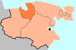
Chaunsky Administrative District is highlighted in orange. Anadyr is marked as a black dot.Coordinates: 68°52′06″N 170°36′29″E / 68.86833°N 170.60806°ECoordinates: 68°52′06″N 170°36′29″E / 68.86833°N 170.60806°E 
Coat of arms Administrative status (as of 2009) Country Russia Federal subject Chukotka Autonomous Okrug[1] Administrative center town of Pevek[2] # of cities/towns 1[citation needed] # of urban-type settlements 6[citation needed] # of rural localities 4[citation needed] Municipal status (as of October 2010) Municipally incorporated as Chaunsky Municipal District[3] - Head of the Administration[4] Yelena Kompaniyets[4] - # of urban settlements 1[3] - # of rural settlements 3[3] Statistics Area (municipal district) (2010) 58,091.41 km2 (22,429.22 sq mi)[4] Population (2002 Census) 6,962 inhabitants[5] - Urban population 83.8% - Rural population 16.2% Population (2010 est.) 5,341 inhabitants[6] Density 0 /km2 (0 /sq mi)[7] Time zone MAGST (UTC+12:00)[8] Established 1933[9] Official website Chaunsky District (Russian: Чаунский район) is an administrative and municipal district (raion), one of the six in Chukotka Autonomous Okrug, Russia.[1] It is located on the northern shore of the autonomous okrug and in terms of the administrative divisions borders Shmidtovsky District in the northeast, Anadyrsky District in the southeast, and Bilibinsky District in the south and west. The area of the district is 58,091.41 square kilometers (22,429.22 sq mi).[4] Its administrative center is the town of Pevek.[2] District's population: 5,341 (2010 est.);[6] 6,962 (2002 Census);[5] 32,167 (1989 Census).[10] Population of Pevek accounts for 74.8% of the district's population.[5]
Chaunsky District is comparatively flat compared to other districts in the autonomous okrug. The land within the current boundaries was first discovered by non-indigenous people in the 18th century, and now the indigenous people of the district are a minority as ethnic Russians came to the area following a growth in mining.
Contents
Geography
The district is centered around Chaunskaya Bay, on the shores of which Pevek, the district administrative center, is situated. The district's territory also includes Ayon Island, found at the entrance to Chaunskaya Bay. There is an eponymous settlement on the island.
The district's territory stretches for 330 kilometers (210 mi) from north to south and for 290 kilometers (180 mi) from east to west.[11] Chaunsky District is significantly flatter than Bilibinsky District located to the west and contains large areas devoted to reindeer pasture.
Approximately 350 kilometers (220 mi) long, the Chaun River, which flows into Chaunskaya Bay, is the longest river in the whole autonomous okrug.[12]
There are a number of wetland areas of significance within the district. The most westerly of these is situated on the Kyttyk Peninsula and the mouth of the Rauchua River.[13] This area is dominated by the Lower Rauchua delta and the alluvial plains of the Kyttyk Peninsula, from which Ayon Island is separated by the Maly Chaunsky Strait.[13] The peninsula is almost completely covered in a complex system of lakes, ranging in size from small saline pools lying on a recently exposed marine terrace 1 to 2 m above sea level, near the coast,[13] to lakes up to 1 km wide and 12 m deep on high level surfaces 10–15 m above sea level.[13] In addition, the peninsula is scored by a number of rivers, the Eyukuul, Koz'mina, Rakvezan and Emykkyvian among the most significant.[13]
The Ust-Chaun area of the district also contains significant wetlands at the south end of Chaunskaya Bay, consisting mainly of an alluvial plain approximately 100 km wide and 60 km north to south.[14] The wetlands at Ust-Chaun are similar in structure to those at the Rauchua / Kyttyk wetland, consisting of a landscape almost entirely filled with small lakes,[14] those nearest Chaunskaya Bay are the smallest and shallowest (less than 70 cm deep)[14] and those on more elevated ground being deeper at 1.5–3 m deep[15] The Ust-Chaun region serves a fishing centre for the inhabitants of Rytkuchi,[16] although this has lost its importance in recent years as stocks of Char have diminished,[16] as a result of overfishing both for sale to the local Sovkhoz and as bait for trapping foxes.[17]
Flora
There are approximately 200 different species of plant within the Rauchua / Kyttyk wetland area comprising a variety of steppe, boreal and arctic species, a number of which occur at the eastern limit of their natural habitat.[18] In the Ust-Chaun area, there are even more recorded plant species, at 252.,[18] including a number of rare species.[19]
Fauna
Humpback and Chum Salmon enter the lower reaches of the Rauchua.[20] Several species of Whitefish, Grayling and Smelt also live in the river or in the many surrounding lakes.[20] Sticklebacks also live in the lakes[21] along with Arctic Char, although the community of Char is infested with Acanthocephala.[13] Similar fish exist in the Ust-Chaun region,[22] and in addition to fish, the wetland is also home to the Siberian Newt, which lives in the shrub-covered tundra near the delta.[22]
The Rauchua / Kyttyk wetland area is considered to be the easternmost extent of so-called "Kolyma fauna", such as the Terek Sandpiper, Brown Shrike and Scarlet Rosefinch.[20] The most common bird species in the Rauchua / Kyttyk wetland are the Yellow-Billed, Black-Throated and Pacific Divers. One of the main reasons for the importance of the Rauchua / Kyttyk is the breeding population (figures as of 1994) of Bewick's Swan (approximately 300 birds), the Pacific Eider (approximately 3,000 birds) and the Spectacled Eider (approximately 2,000 birds).[23] Spectacled and Pacific Eider as well as Black-throated and Pacific Divers are also found in the Ust-Chaun region, though trhe Pacific Eider is much more common on the Kyttyl Peninsula and near Apapelgino.[22]
Birds of prey are found in the Ust-Chaun area, with the Rough-legged Buzzard nesting in the area and species such as the Goshawk and Peregrine Falcon visiting the area regularly.[16] Their prey consists of a wide variety of small mammals and almost all mammels found in the tundra regions of the Russian Far East are found in the Ust-Chaun area, including a number of species of Shrew, Vole and Lemming.[16] Larger mammels include wild Reindeer, wolves and Brown Bear.[16]
Demographics
Approximately 85% of the district's population in 2003 were non-indigenous peoples.[12] As with most of the districts in Chukotka, indigenous peoples are more often found in the scattered rural localities, while ethnic Russians are more often found in the urban areas. These people either migrated to the Far East, or are the descendants of those who did, enticed by the higher pay, large pensions, and more generous allowances permitted to those prepared to endure the cold and the isolation, or, more likely, were exiled here as a result of one of Stalin's purges, or were exiled here having been released from the Gulag. The existence of the port of Pevek in the district is a major reason for the presence of ethnic Russians.[12]
The indigenous people present in the district are almost exclusively Chukchi.[24] An environmental impact study produced by Bema Gold for the Kupol gold project states that at the start of 2004, 846 of the districts inhabitants were of indigenous origin.[25] Of these people, 841 were Chukchi,[25] with 2 reported as Yupik, 2 Mansi and 1 Even comprising the remaining five indigenous individuals.[25] The indigenous people of Chaunsky District reside mainly in Rytkuchi, Ayon and Yanranay.[25]
History
18th and 19th centuries
The area of what is now Chaunsky District was first visited by non-indigenous people, when Karl Merk came across the Chaun River, as part of the overland element of the Billings Expedition—the expedition ordered by Catherine the Great and led by Englishman Joseph Billings in an attempt to find a true Northeast Passage. Prior to the river's discovery by Merk, the Chaun River represented the westernmost boundary of the Chukchi land. Merk named the river Chavaveyam after Mount Chaun, from where the river springs.[12]
The Rauchua River was a place inhabited by mammoths in prehistoric times and was also the scene of a bloody battle between Chukchi herders and a combination of Yukaghirs and Evens during the 19th century. The name Rauchua comes from the Chukchi word "Ravchyvan", meaning place of a victory over a camp.[12]
20th century
The district in its present form was founded in 1933.[9] Gold and tin were discovered in the 1940s, which led to the first occurrences of industrial mining in the district in the 1950s. The effect of this growth in industry was that Chaunsky District became the first district in the region to have a road network constructed as well as an electricity grid.[12] During the Second World War, the Chaunskaya Bay area of Chaunsky District was the most important tin producing area in the whole of the Soviet Union.[26]
Transportation
The district has a developed transport infrastructure compared to the rest of Chukotka; in part helped by the presence of Pevek. Pevek itself has the second largest airport in Chukotka after Ugolny Airport and offers one of the few means of direct air travel to Moscow. Pevek is also the naval headquarters of the East Arctic during the short summer.
Economy
Industrial and administrative
Many of the populated places throughout Chukotka owe their existence to tin and gold mines, and deposits of these metals were first discovered in Chukotka in Chaunsky District in 1941. In 2002, the average monthly salary was just over 11,000 rubles per month,[25] although agricultural wages were on average only around half that per month.[25] Mining and ancillary services still form the major elements of the economy of Chaunsky District. There are two large mines and a number of small mines in the district,[25] supported by a large trucking company.[25]
Traditional and cultural
Compared to other districts in Chukotka, agricultural enterprise is not particularly well developed.[25] There is only one farming brigade, Chaunskoye, employing just under 200 people.[25] The brigade herds around 15,000 reindeer and is also involved in fishing.[25]
Transport
As a result of the development of the mining industry, Chaunsky District also has the most developed road transport network in Chukotka, with paved, unpaved, or snow roads leading from Pevek to all major population hubs.[12] Pevek Airport, located about 14 km from Pevek provides a link for the region to Moscow.[25] Pevek's port is the largest in Chukotka and is generally open for about two and a half months a year from mid-July to September.[25]
Divisions
Administrative divisions
Chaunsky Administrative District has administrative jurisdiction over one town, six urban-type settlements, and four rural localities, consisting of all the inhabited localities listed below in the "Municipal divisions" section, except for Billings, which is administratively subordinated to Shmidtovsky District.
Municipal divisions
Chaunsky Municipal District is divided into one urban settlement and three rural settlements:
Municipal composition Urban settlements Inhabited localities in jurisdiction Pevek
(Певек)Rural settlements Rural localities in jurisdiction* Ayon
(Айон)- selo of Ayon
Billings
(Биллингс)- selo of Billings
Rytkuchi
(Рыткучи)- selo of Rytkuchi
Inhabited localities being liquidated - urban-type settlement of Baranikha
- urban-type settlement of Bystry
- urban-type settlement of Komsomolsky
- urban-type settlement of Krasnoarmeysky
- urban-type settlement of Valkumey
- urban-type settlement of Yuzhny
Source:[3]
*Administrative centers are shown in boldReferences
Notes
- ^ a b Law #33-OZ, Article 9.2
- ^ a b Law #33-OZ, Article 16.2
- ^ a b c Law #46-OZ
- ^ a b c d Official website of Chukotka Autonomous Okrug. Chaunsky District
- ^ a b c Федеральная служба государственной статистики (Federal State Statistics Service) (2004-05-21). "Численность населения России, субъектов Российской Федерации в составе федеральных округов, районов, городских поселений, сельских населённых пунктов – районных центров и сельских населённых пунктов с населением 3 тысячи и более человек (Population of Russia, its federal districts, federal subjects, districts, urban localities, rural localities—administrative centers, and rural localities with population of over 3,000)" (in Russian). Всероссийская перепись населения 2002 года (All-Russia Population Census of 2002). Federal State Statistics Service. http://www.perepis2002.ru/ct/doc/1_TOM_01_04.xls. Retrieved 2010-03-23.
- ^ a b Федеральная служба государственной статистики (Federal State Statistics Service). Численность постоянного населения Российской Федерации по городам, посёлкам городского типа и районам на 1 января 2010 г. (Permanent Population of the Russian Federation by Cities/Towns, Urban-Type Settlements, and Districts as of January 1, 2010) (Russian)
- ^ The value of density was calculated automatically by dividing the 2002 Census population by the area specified in the infobox. Please note that this value may not be accurate as the area specified in the infobox does not necessarily correspond to the area of the entity proper or is reported for the same year as the population.
- ^ Правительство Российской Федерации. Постановление №725 от 31 августа 2011 г. «О составе территорий, образующих каждую часовую зону, и порядке исчисления времени в часовых зонах, а также о признании утратившими силу отдельных Постановлений Правительства Российской Федерации». Вступил в силу по истечении 7 дней после дня официального опубликования. Опубликован: "Российская Газета", №197, 6 сентября 2011 г. (Government of the Russian Federation. Resolution #725 of August 31, 2011 On the Composition of the Territories Included into Each Time Zone and on the Procedures of Timekeeping in the Time Zones, as Well as on Abrogation of Several Resolutions of the Government of the Russian Federation. Effective as of after 7 days following the day of the official publication).
- ^ a b Charter of Chaunsky District (2002), Article 2.1
- ^ "Всесоюзная перепись населения 1989 г. Численность наличного населения союзных и автономных республик, автономных областей и округов, краёв, областей, районов, городских поселений и сёл-райцентров. (All Union Population Census of 1989. Present population of union and autonomous republics, autonomous oblasts and okrugs, krais, oblasts, districts, urban settlements, and villages serving as district administrative centers.)" (in Russian). Всесоюзная перепись населения 1989 года (All-Union Population Census of 1989). Demoscope Weekly (website of the Institute of Demographics of the State University—Higher School of Economics. 1989. http://demoscope.ru/weekly/ssp/rus89_reg.php. Retrieved 2010-03-23.
- ^ Law #46-OZ, Appendix 2.1
- ^ a b c d e f g Futé, p. 106f
- ^ a b c d e f Andreev, p.41
- ^ a b c Andreev, A.V. p.43
- ^ Andreev, A.V. p.44
- ^ a b c d e Andreev, A.V. p.47
- ^ Andreev, A.V. p.48
- ^ a b Yurtsev B.A., Problemy Botanicheskoy Geografii Severovostochnoy Azii (Problems of Botanical Geography of Northeastern Asia). Leningrad: Nauka, 1974, p. 159. (Russian)
- ^ Berkutenko A.N. (1987) Redkiye Rasteniya Magadanskoy Oblasti (Rare Plants of Magadan Region). Preprint. Magadan, p.74. (Russian)
- ^ a b c Andreev, p.42
- ^ Chereshnev I.A. Origin of Beringian Freshwater Ichthyofauna. Biogeografiya Beringiyskogo Sektora Subarktiki (Biogeography of the Beringian sector of the Subarctic). Vladivostok: Izd-co DVNTs, 1986, pp. 122-145. (Russian)
- ^ a b c Andreev, A.V. p.46
- ^ Hodges J.I. and Eldridge W.D. (1994).Aerial Waterfowl Surveys on the Arctic coast of Eastern Russia. Unpublished USFWS report. Anchorage, p. 20.
- ^ Norwegian Polar Institute. Indigenous Peoples of the north of the Russian Federation, Map 3.6, Chukotskiy Avtonomyy Okrug
- ^ a b c d e f g h i j k l m Environmental Impact Assessment, Kupol Gold Project, Far East Russia June 2005, prepared by Bema Gold Corporation, p.89.
- ^ Some Notes on the Soviet Arctic During the Past Decade, WIlliam Mandel, Arctic, Vol. 3, No. 1 (1950).
Sources
- Дума Чукотского автономного округа. Закон №33-ОЗ от 30 июня 1998 г. «Об административно-территориальном устройстве Чукотского автономного округа», в ред. Закона №73-ОЗ от 24 июня 2009 г. «О внесении изменений в Закон Чукотского автономного округа "Об административно-территориальном устройстве Чукотского автономного округа"». Вступил в силу по истечении десяти дней со дня его официального опубликования. Опубликован: "Ведомости", №7 (28), 14 мая 1999 г. (Duma of Chukotka Autonomous Okrug. Law #33-OZ of June 30, 1998 On the Administrative and Territorial Structure of Chukotka Autonomous Okrug, as amended by the Law #73-OZ of June 24, 2009 On Amending the Law of Chukotka Autonomous Okrug "On the Administrative and Territorial Structure of Chukotka Autonomous Okrug". Effective as of after ten days from the day of the official publication).
- Дума Чукотского автономного округа. Закон №46-ОЗ от 29 ноября 2004 г. «О статусе, границах и административных центрах муниципальных образований на территории Чаунского района Чукотского автономного округа», в ред. Закона №87-ОЗ от 20 октября 2010 г «О преобразовании путём объединения поселений на территории Чаунского муниципального района и внесении изменений в Закон Чукотского автономного округа "О статусе, границах и административных центрах муниципальных образований на территории Чаунского района Чукотского автономного округа"». Вступил в силу через десять дней со дня официального опубликования. Опубликован: "Ведомости", №31/1 (178/1), 10 декабря 2004 г. (Duma of Chukotka Autonomous Okrug. Law #46-OZ of November 29, 2004 On the Status, Borders, and Administrative Centers of the Municipal Formations on the Territory of Chaunsky District of Chukotka Autonomous Okrug, as amended by the Law #87-OZ of October 20, 2010 On the Transformation via Merger of the Settlements on the Territory of Chaunsky Municipal District and on Amending the Law of Chukotka Autonomous Okrug "On the Status, Borders, and Administrative Centers of the Municipal Formations on the Territory of Chaunsky District of Chukotka Autonomous Okrug". Effective as of the day which is ten days after the official publication date).
- Wetlands in Russia, Vol. 4 Wetlands in Northeastern Russia, Andreev, A.V. (2004). Wetlands International, Moscow.
- Petit Futé, Chukotka
Administrative divisions of Chukotka Autonomous Okrug Administrative center: AnadyrCities and towns 
Urban-type settlements Aliskerovo · Baranikha · Beringovsky · Bystry · Dalny · Egvekinot · Komsomolsky · Krasnoarmeysky · Leningradsky · Mys Shmidta · Otrozhny · Provideniya · Shakhtyorsky · Ugolnye Kopi · Valkumey · Vesenny · Vstrechny · YuzhnyAdministrative districts (raions) Categories:- Districts of Chukotka Autonomous Okrug


Wikimedia Foundation. 2010.