- Mys Shmidta
-
Mys Shmidta (English)
Мыс Шмидта (Russian)- Urban-type settlement[1] -
Work settlement[1]
Location of Chukotka Autonomous Okrug in Russia
 Mys ShmidtaLocation of Mys Shmidta in Chukotka Autonomous Okrug
Coordinates: 68°52′06″N 179°22′24″W / 68.86833°N 179.37333°WCoordinates: 68°52′06″N 179°22′24″W / 68.86833°N 179.37333°W Administrative status (as of June 2011) Country Russia Federal subject Chukotka Autonomous Okrug[1] Administrative district Iultinsky District[citation needed] Municipal status (as of June 2009) Municipal district Iultinsky Municipal District[2] Urban settlement Mys Shmidta Urban Settlement[2] Statistics Area (urban settlement) (June 2009) 137.81 km2 (53.21 sq mi)[3] Population (2002 Census) 705 inhabitants[4] Population (2006 est.) 760 inhabitants[5] Density 5 /km2 (13 /sq mi)[6] Time zone MAGST (UTC+12:00)[7] Founded 1931[8] Urban-type settlement status since 1962[8] Postal code(s) 689350[9] Dialing code(s) +7 42739[10] Mys Shmidta (Russian: Мыс Шми́дта, lit. Cape Schmidt) is an urban-type settlement (a work settlement)[1] in Iultinsky District of Chukotka Autonomous Okrug, Russia. The settlement is located about 5 kilometres (3 mi) southeast of the cape of the same name. The cape, but not the settlement, was formerly known as North Cape or Cape North. Cape Billings is located to the west of it and Cape Vankarem is located to the east. Population: 705 (2002 Census);[4] 4,587 (1989 Census).[11] Municipally, Mys Shmidta is incorporated as Mys Shmidta Urban Settlement.[2]
The settlement was founded in 1931[8] as a part of the Soviet Union's development of its Arctic air defences. Changes in the manner in which national defences are constructed in recent decades has led to a decline in Mys Shmidta's importance, though the settlement remains one of the main northern sea ports for Chukotka after Pevek.
Contents
Geography
The settlement is located on the shore of the Chukchi Sea (part of the Arctic Ocean), south of Wrangel Island and about 650 kilometres (400 mi) from Anadyr, the administrative centre of the autonomous okrug. The settlement itself is positioned on a spit which separates the Akatan Lagoon from the open sea and protects the airport from the full effects of the Arctic Ocean. A little distance to the north-west of the settlement is the cape from which the settlement gets its name and just beyond this lies the Chukchi village of Ryrkaypiy.
Administrative vs. municipal jurisdiction
Until July 2008, Mys Shmidta was a part of both Shmidtovsky Municipal and Shmidtovsky Administrative District and served as the administrative centre of both. In May 2008, Shmidtovsky Municipal District was merged into Iultinsky Municipal District[12] (the administrative centre of which is Egvekinot); however, this change did not affect the borders of Shmidtovsky Administrative District. Mys Shmidta continued to serve as the administrative centre of the latter until June 2011, when Shmidtovsky Administrative District was merged into Iultinsky Administrative District and ceased to exist.
History
Cape North, as Cape Schmidt was then called,[13] was first reached by James Cook in 1778 when he sailed through the Bering Strait and into the Chukchi Sea, demonstrating to people in Europe and North America that Russia and Alaska were separated.[14]
The modern settlement was founded in 1931[8] as part of the Soviet Union's attempts to develop the extreme north-east of the country. The settlement itself, its airport, and the nearby cape were all named after Otto Schmidt, with Mys Shmidta forming the central base for the enterprises involved in the mining of tin and gold. The surrounding area from Tiksi and Pevek to Nordvik and Maria Pronchishcheva Bay experienced a comparative boom as the first icebreakers began carrying goods and people along the Northern Sea Route.
In 1954, the airfield was developed as part of the Soviet Air Force's plan to create a ring of air bases around the arctic for the use of its strategic bomber fleet during the Cold War. During the Cold War, this airfield formed a network of forward staging bases inside the Arctic Circle. The use of strategic bomber forward staging bases was dictated by geography and weather. The northern parts of the Soviet Union closest to the United States are in the Arctic, with hostile weather conditions. Consequently, Soviet strategic bombers were normally stationed at bases in more temperate parts of the Soviet Union, flying training missions from these forward staging bases.[15]
In 1962, the settlement was granted urban-type settlement status.[8]
However, the focus on intercontinental ballistic missiles as opposed to bombers meant that the airfield became less important and eventually closed for military use in the early 1990s. Around the same time, mining on an industrial scale also ceased. These two events caused a major outflow of people, leaving only around 15% of the 1990 population still in the settlement in 2008.
Demographic Evolution 1970 1979 1989 2002 2006 1,818 3,307 4,587 [11] 705 [4] 760 [10] Climate
 Otto Schmidt, the Soviet scientist for whom the settlement was named
The overall climate of Shmidtovsky District is more severe than in neighbouring Alaska and varies significantly throughout the year. By the very nature of the position of the settlement, it is at the mercy of Arctic conditions, that leave it stranded throughout the winter and can pose a danger to shipping during the brief summer as supply ships try to make their delivery. The importance attached to the summer months from a logistical standpoint was well illustrated in 1983, when winter set in earlier than predicted and resulted in Mys Shmidta and a number of other coastal ports in the Russian Far East to shut early due to ice, leaving Pevek as the only open port in the region and leaving dozens of ships stuck in the ice of the Chukchi Sea.[16] Although unloading was delayed due to ice for a fortnight, the first supply ship convoy to Mys Shmidta arrived as planned.[17] However, a severe drop in temperature through August, much earlier than usual, caused a significantly greater concentration of ice in the De Long Strait and strong northerly winds forcing the semi-permanent Ayon ice sheet onto the northern coast of Chukotka.[16]
By October, the ice had thickened to such a degree that a convoy of ships, including the freighter Nina Sagaydak, Kamensk-Uralsky, together with the nuclear icebreakers Kapitan Sorokin and Vladivostok, was held fast by October in sea ice about half way between Mys Shmidta and Vankarem.[17] This proved chaotic with several ships drifting freely in the ice, hulls grinding against one another. Although the ships eventually separated, the damage cause to the Nina Sagaydak proved too severe and she sank; the first ship to be sunk by ice in Soviet waters since the Vitimles in 1963.[16] The remaining ships were freed by icebreakers and towed to the edge of the sea ice.
This extreme weather, even for this area forced the closure of all Arctic ports except Pevek. This situation placed great strain on the town's resources as it struggled to deal with such a large amount of shipping and the associated problem of how to store a much larger than usual quantity of cargo, much of which was not intended to be frozen, while authorities readied the winter snow roads.[16] These events highlight how dangerous the climate in Mys Shmidta and the surrounding area can be, particularly if winter closes in earlier than expected, creating additional danger for the settlement and any shipping in the vicinity, as well as placing considerable additional pressure on Pevek's already decaying infrastructure.
Climate data for Mys Shmidta Month Jan Feb Mar Apr May Jun Jul Aug Sep Oct Nov Dec Year Record high °C (°F) −1
(30)1
(34)1
(34)6
(43)11
(51)24
(75)29
(84)26
(78)18
(64)5
(41)3
(37)5
(41)29
(84)Average high °C (°F) −22
(−7)−23
(−9)−22
(−7)−15
(5)−4
(24)3
(37)7
(44)6
(42)1
(34)−7
(19)−14
(6)−21
(−5){{{year high C}}}
(15)Average low °C (°F) −27
(−16)−28
(−18)−27
(−16)−21
(−5)−9
(16)0
(32)2
(36)2
(36)−2
(28)−11
(12)−18
(0)−26
(−14){{{year low C}}}
(6)Record low °C (°F) −44
(−47)−46
(−50)−42
(−43)−38
(−36)−30
(−22)−8
(17)−4
(24)−4
(24)−14
(6)−28
(−18)−37
(−34)−41
(−41)−46
(−50)Rainfall mm (inches) 22.9
(0.902)15.2
(0.598)12.7
(0.5)10.2
(0.402)12.7
(0.5)15.2
(0.598)33
(1.3)43.2
(1.701)35.6
(1.402)15.2
(0.598)35.6
(1.402)17.8
(0.701)287
(11.3)Source: Weather Reports[18] Culture and sights
Mys Shmidta is the starting point for any tourist wishing to explore the Wrangel Island UNESCO World Heritage Site. The nature reserve's headquarters are based in Mys Shmidta.[19]
Unlike the majority of other inhabited localities in Chukotka, Mys Shmidta is one of the few settlements without a local cultural museum.
Economy
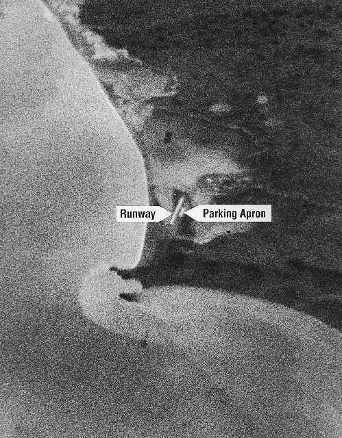
 Mys Shmidta, 1961. The first recovered image from the Corona spy satellite (Note that in the image, North is roughly toward the bottom of the picture).
Port
The port at Mys Shmidta is generally open between July and September, although the waters surrounding the port are shallow which limits the type of ships that can serve the area. The port is operated by the Russian firm Almazzoloto.[20]
Though it has shrunk since the days of the Cold War, Mys Shmidta is still the main northern sea port in Chukotka along with Pevek.[20] Following the collapse of the Soviet Union, imports all but ceased in the early to mid-1990s, although in 1991 Mys Shmidta, importing nearly 30,000 tons of mainly American fuel, dealt with significantly more cargo than ports such as Pevek. For comparison, a port such as Mys Shmidta was handling several hundred thousand tons of cargo a year during the 1980s.[20] The decline in the overall volume of cargo passing through Mys Shmidta continued throughout the 1990s, with less than 50,000 tons being handled in 1997 and just over 1,000 tons the following year,[20] This is in part due to the declining economy of the region, which has caused a fall in investment in the port infrastructure. This in turn limits the maximum potential turnover of the port.
It is difficult to see where future cargo exports would come from. While gold is mined in Bilibino with lower-level mining at Iultin and Polyarny, these concerns do not produce significant cargo volumes for the northern sea route, and nor does the extraction of any other minerals in the area, from which Mys Shmidta could benefit.[20] Although part of the Northern Sea Route's series of ports, Mys Shmidta, as a port, will be dominated by imports of food and coal for the settlement and the surrounding villages.
A federal government decision in 1997 led to the establishment of an emergency radio station in Mys Shmidta as well as other northern Sea route ports to specifically monitor distress and salvage frequencies.[21]
Other infrastructure
The settlement is populated now mostly by indigenous people, whose economy is driven mainly by reindeer herding and low level gold mining. However, there is little mining done in the vicinity of Mys Shmidta, with the three main prospecting teams in the region: Polyarnaya, Arktikaand, and Shakhtar being based in Leningradsky.[10]
There remains a meteorological station in the settlement.[22]
Immediately to the south-west of the settlement is Mys Shmidta Airport. The airport is now employed solely for civilian usage providing flights to Anadyr. Flights are provided by Chukotavia.
As with all areas of Siberia and the Russian Far East, there is very limited road transport. There is a road, however, linking Mys Shmidta with Egvekinot.[10] There is also a 435 kilometres (270 mi) unpaved road between Mys Shmidta and Komsomolsky, of which 235 kilometres (146 mi) is unpaved road and the remaining 199 kilometres (124 mi) is a snow road.[10]
References
Notes
- ^ a b c d Law #33, Article 12.2
- ^ a b c Law #149, Article 8
- ^ Law #149, Appendix 16
- ^ a b c Федеральная служба государственной статистики (Federal State Statistics Service) (2004-05-21). "Численность населения России, субъектов Российской Федерации в составе федеральных округов, районов, городских поселений, сельских населённых пунктов – районных центров и сельских населённых пунктов с населением 3 тысячи и более человек (Population of Russia, its federal districts, federal subjects, districts, urban localities, rural localities—administrative centers, and rural localities with population of over 3,000)" (in Russian). Всероссийская перепись населения 2002 года (All-Russia Population Census of 2002). Federal State Statistics Service. http://www.perepis2002.ru/ct/doc/1_TOM_01_04.xls. Retrieved 2010-03-23.
- ^ Fute, p. 2
- ^ The value of density was calculated automatically by dividing the 2002 Census population by the area specified in the infobox. Please note that this value may not be accurate as the area specified in the infobox does not necessarily correspond to the area of the entity proper or is reported for the same year as the population.
- ^ Правительство Российской Федерации. Постановление №725 от 31 августа 2011 г. «О составе территорий, образующих каждую часовую зону, и порядке исчисления времени в часовых зонах, а также о признании утратившими силу отдельных Постановлений Правительства Российской Федерации». Вступил в силу по истечении 7 дней после дня официального опубликования. Опубликован: "Российская Газета", №197, 6 сентября 2011 г. (Government of the Russian Federation. Resolution #725 of August 31, 2011 On the Composition of the Territories Included into Each Time Zone and on the Procedures of Timekeeping in the Time Zones, as Well as on Abrogation of Several Resolutions of the Government of the Russian Federation. Effective as of after 7 days following the day of the official publication).
- ^ a b c d e Russian Academy of Sciences. Institute of Geography. Information about Mys Shmidta (Russian)
- ^ Russian Post. Mys Shmidta (Russian)
- ^ a b c d e Fute, p. 139ff
- ^ a b "Всесоюзная перепись населения 1989 г. Численность наличного населения союзных и автономных республик, автономных областей и округов, краёв, областей, районов, городских поселений и сёл-райцентров. (All Union Population Census of 1989. Present population of union and autonomous republics, autonomous oblasts and okrugs, krais, oblasts, districts, urban settlements, and villages serving as district administrative centers.)" (in Russian). Всесоюзная перепись населения 1989 года (All-Union Population Census of 1989). Demoscope Weekly (website of the Institute of Demographics of the State University—Higher School of Economics. 1989. http://demoscope.ru/weekly/ssp/rus89_reg.php. Retrieved 2010-03-23.
- ^ Law #40, Article 1.4
- ^ J. C. Beaglehole. The Life of Captain James Cook, p. 621
- ^ M. C. Serreze and R. G. Barry. The Arctic Climate System, p. 5
- ^ Globalsecurity.org
- ^ a b c d W. Barr and E. A. Wilson. The Shipping Crisis in the Soviet Eastern Arctic at the Close of the 1983 Navigation Season
- ^ a b V. Martyshin. On the Route from Pevek, Vodny Transport
- ^ "Weather Reports — Weather Averages for Mys Shmidta". http://www.weatherreports.com/Russia/Mys_Shmidta/averages.html?n=1. Retrieved May 1, 2010.
- ^ United Nations Environment Programme. Natural System Of Wrangel Island Reserve, Chukotka, Russian Federation, p. 7
- ^ a b c d e C. L. Ragner. Northern Sea Route Cargo Flows and Infrastructure – Present State and Future Potential
- ^ Y. M. Ivanov, A. P. Ushakov, and A. N. Yakovlov. Russian Administration of the Northern Sea Route, Central INSROP Working Paper, #106.
- ^ Nsidc.org. Precipitation Station Analysis
Sources
- Дума Чукотского автономного округа. Закон №33-ОЗ от 30 июня 1998 г. «Об административно-территориальном устройстве Чукотского автономного округа», в ред. Закона №73-ОЗ от 24 июня 2009 г. «О внесении изменений в Закон Чукотского автономного округа "Об административно-территориальном устройстве Чукотского автономного округа"». Вступил в силу по истечении десяти дней со дня его официального опубликования. Опубликован: "Ведомости", №7 (28), 14 мая 1999 г. (Duma of Chukotka Autonomous Okrug. Law #33-OZ of June 30, 1998 On the Administrative and Territorial Structure of Chukotka Autonomous Okrug, as amended by the Law #73-OZ of June 24, 2009 On Amending the Law of Chukotka Autonomous Okrug "On the Administrative and Territorial Structure of Chukotka Autonomous Okrug". Effective as of after ten days from the day of the official publication).
- Дума Чукотского автономного округа. Закон №40-ОЗ от 30 мая 2008 г. «О преобразовании муниципальных образований Иультинский муниципальный район и Шмидтовский муниципальный район и о внесении изменений в отдельные законодательные акты Чукотского автономного округа», в ред. Закона №79-ОЗ от 25 июня 2009 г «О внесении изменения в Закон Чукотского автономного округа "О преобразовании муниципальных образований Иультинский муниципальный район и Шмидтовский муниципальный район и о внесении изменений в отдельные законодательные акты Чукотского автономного округа"». Вступил в силу через десять дней со дня официального опубликования. Опубликован: "Ведомости", №22/1 (349/1), 6 июня 2008 г. (Duma of Chukotka Autonomous Okrug. Law #40-OZ of May 30, 2008 On the Transformation of the Municipal Formations of Iultinsky Municipal District and Shmidtovsky Municipal District an on Amending Certain Legislative Acts of Chukotka Autonomous Okrug, as amended by the Law #79-OZ of June 25, 2009 On Amending the Law of Chukotka Autonomous Okrug "On the Transformation of the Municipal Formations of Iultinsky Municipal District and Shmidtovsky Municipal District an on Amending Certain Legislative Acts of Chukotka Autonomous Okrug". Effective as of the day ten days after the official publication date).
- Petit Fute. Chukotka.
- Дума Чукотского автономного округа. Закон №149-ОЗ от 24 ноября 2008 г. «О статусе, границах и административных центрах муниципальных образований на территории Иультинского муниципального района Чукотского автономного округа», в ред. Закона №85-ОЗ от 20 октября 2010 г «Об упразднении сельского поселения Нутэпэльмен Иультинского муниципального района Чукотского автономного округа и о внесении изменений в отдельные законодательные акты Чукотского автономного округа». Вступил в силу через десять дней со дня официального опубликования. Опубликован: "Ведомости", №46/1 (373/1), 28 ноября 2008 г. (Duma of Chukotka Autonomous Okrug. Law #149-OZ of November 24, 2008 On the Status, Borders, and Administrative Centers of the Municipal Formations on the Territory of Iultinsky Municipal District of Chukotka Autonomous Okrug, as amended by the Law #85-OZ of October 20, 2010 On the Abolition of Nutepelmen Rural Settlement of Iultinsky Municipal District of Chukotka Autonomous Okrug and on Amending Several Legislative Acts of Chukotka Autonomous Okrug. Effective as of the day ten days after the official publication date).
External links
Administrative divisions of Chukotka Autonomous Okrug Administrative center: AnadyrCities and towns 
Urban-type settlements Aliskerovo · Baranikha · Beringovsky · Bystry · Dalny · Egvekinot · Komsomolsky · Krasnoarmeysky · Leningradsky · Mys Shmidta · Otrozhny · Provideniya · Shakhtyorsky · Ugolnye Kopi · Valkumey · Vesenny · Vstrechny · YuzhnyAdministrative districts (raions) Categories:- Populated places of Arctic Russia
- Chukchi Sea
- Urban-type settlements in Chukotka Autonomous Okrug


Wikimedia Foundation. 2010.